

klw
-
Posts
5,007 -
Joined
-
Last visited
Content Type
Profiles
Blogs
Forums
American Weather
Media Demo
Store
Gallery
Everything posted by klw
-
2.25 at home in past hour or so. 7.28 in August and over 30 inches since June started. https://www.wunderground.com/dashboard/pws/KVTNORWI24
-
DETOUR LARGE TRUCKS - RUTLAND TOWN/RUTLAND CITY http://vtstatepolice.blogspot.com/2023/08/detour-large-trucks-rutland-townrutland.html State of Vermont Department of Public Safety Vermont State Police Rutland Barracks News Release - Highway / Traffic Notification All large trucks whose destination is north of Rutland City via US 7 are asked to detour via US 4 West and then 22A or RT 30 NB to access destinations north of Rutland City. US 7 NB through Rutland City is not suitable for any large vehicles at this time. This is due to flooding and road closures in the area. Updates will be provided as details are available. Motorists should expect delays in the area or seek alternate routes. Please drive carefully.
-
To think I only had 5 inches of rain in May. The 27 inches since June 1st have wiped away that abnormal dryness.
-
This Mendon station shows 4.31 so far https://www.wunderground.com/dashboard/pws/KVTRUTLA25 This one east of Clarendon is next highest I have found in that area at 2.44 https://www.wunderground.com/dashboard/pws/KVTCUTTI1 2.49 at the one by my house.
-
Rate is now over 3/hr.
-
Up over 2 inches at the house now, 1.72 hr/rate https://www.wunderground.com/dashboard/pws/KVTNORWI24
-
Close call for Amtrak in VT last night: https://www.wunderground.com/dashboard/pws/KVTNORWI24
-
House got some more, up to 1.32 on the day now. https://www.wunderground.com/dashboard/pws/KVTNORWI24
-
.86 at home so far today after just under half an inch last night. (.46 IIRC)
-
https://www.wcax.com/2023/08/04/flash-flooding-washes-out-roads-addison-county/ https://www.wcax.com/2023/08/04/three-people-rescued-car-trapped-middlebury-flooding/ It looks like another round in NYS may be heading towards Middlebury.
-
46 here
-
Use your Illusion.
-

July has arrived ... the Meteorologically defined mid summer month
klw replied to Typhoon Tip's topic in New England
13.48 for July to date here after 8.46 in June 21.94 in 7 weeks. On the plus side was last night's rainbow: Yes Hyde Park Vermont is hopping at 7:30 on a Friday night. (I stood and lingered in the middle of the road to look)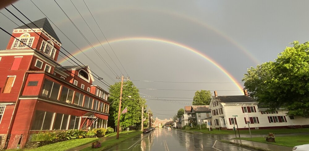
-
July has arrived ... the Meteorologically defined mid summer month
klw replied to Typhoon Tip's topic in New England
This was invaluable up here of late. I don't know if it as thorough down in Mass. https://newengland511.org/ -
July has arrived ... the Meteorologically defined mid summer month
klw replied to Typhoon Tip's topic in New England
Plus they live in Arizona and its the summer. -
July has arrived ... the Meteorologically defined mid summer month
klw replied to Typhoon Tip's topic in New England
I missed them. They finished up (at least their original run) before I got old enough to go to shows. -
July has arrived ... the Meteorologically defined mid summer month
klw replied to Typhoon Tip's topic in New England
They were the band I always wanted to see live when I was young but never was able. My only complaint about current country music that I run across on the radio is the amount of autotuning is odd to me for that genre in particular. -
I'll take ""Rejected TV pilot shows" for 100 Alex
-
July has arrived ... the Meteorologically defined mid summer month
klw replied to Typhoon Tip's topic in New England
I manged to make it home, some light rain now. 2.41 so far. No issues around the house. -
July has arrived ... the Meteorologically defined mid summer month
klw replied to Typhoon Tip's topic in New England
Big Country was better -
July has arrived ... the Meteorologically defined mid summer month
klw replied to Typhoon Tip's topic in New England
T/he 2.31 so far today takes us to 12.15 so far in July after 8.46" in June. 20.61 inches in 48 days, -
July has arrived ... the Meteorologically defined mid summer month
klw replied to Typhoon Tip's topic in New England
But have they installed? -
Looks like the sun is out at home. Worst of the 3rd storm missed from the looks of it. 2.31 total. NWS issued a Flash Flood Warning. https://forecast.weather.gov/showsigwx.php?warnzone=VTZ021&warncounty=VTC027&firewxzone=VTZ035&local_place1=West Norwich VT&product1=Flash+Flood+Warning&lat=43.7543&lon=-72.3728
-
Wife reports backyard is series of waterfalls again with the flat area having more water than last Monday. Town (4 miles away) is dry. Now at 2.02 inches and another cell has formed behind the first 2.
-
1.5"+ in past 45 minutes at our house. https://www.wunderground.com/dashboard/pws/KVTNORWI24


