Newman
-
Posts
2,479 -
Joined
-
Last visited
Content Type
Profiles
Blogs
Forums
American Weather
Media Demo
Store
Gallery
Everything posted by Newman
-
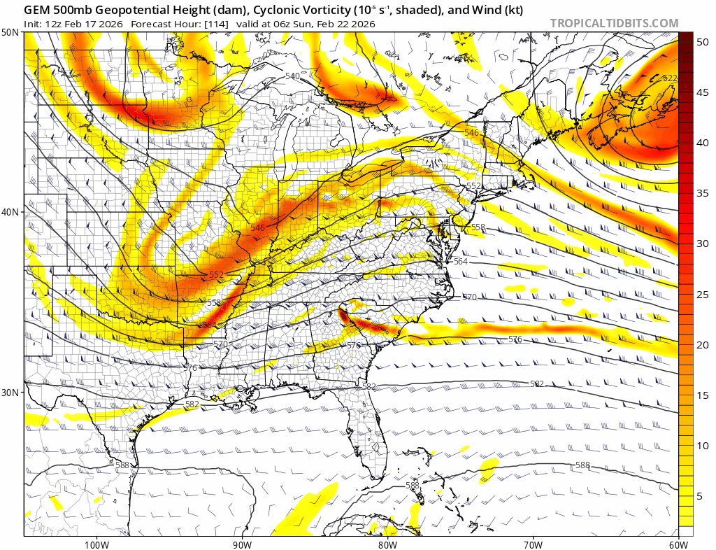
Let's get these 12z runs rocking and rolling. Just a few more ticks with the Euro trough consolidation/orientation and the coastal folks are happy. Just something to work with is what I'd hope for. I think the AIFS is a happy medium and reasonable solution right now. A plowable snow along the coast is looking more likely now, at the least. My family is flying down to see me in Tallahassee tomorrow morning, supposed to fly back Monday morning back into Philly... We'll see if that ends up happening but I'm leaning towards a day cancellation
-

E PA/NJ/DE Winter 2025-26 Obs/Discussion
Newman replied to LVblizzard's topic in Philadelphia Region
It was definitely improved though. I think we'll ultimately end up meeting in the middle between the GFS and Euro with a modest coastal scraper. Maybe the IVT gives some surprises for those inland. -
E PA/NJ/DE Winter 2025-26 Obs/Discussion
Newman replied to LVblizzard's topic in Philadelphia Region
At the upper levels, the 6z Euro continues to make big leaps towards a more consolidated trough like the GFS. I know the surface may not reflect these changes yet (outside of the IVT), but it's getting there. The difference between the GFS and Euro right now is the GFS tilts that trough neutral through the Ohio Valley and the Euro keeps it positive 6-12 hours longer.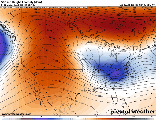
-
E PA/NJ/DE Winter 2025-26 Obs/Discussion
Newman replied to LVblizzard's topic in Philadelphia Region
That's also just a product of the poor airmass we have ahead of the system. It wouldn't shock me if places started as rain, especially along the coast, before the system gets wound up. Assuming this system does impact, of course. -
E PA/NJ/DE Winter 2025-26 Obs/Discussion
Newman replied to LVblizzard's topic in Philadelphia Region
GEFS continues to tick better. Gets the 0.5" QPF line just SE of Philly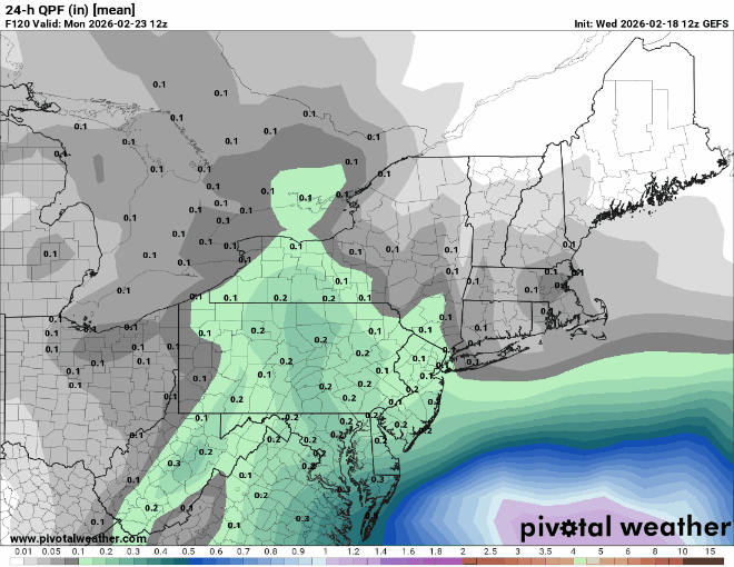
-
E PA/NJ/DE Winter 2025-26 Obs/Discussion
Newman replied to LVblizzard's topic in Philadelphia Region
Just for fun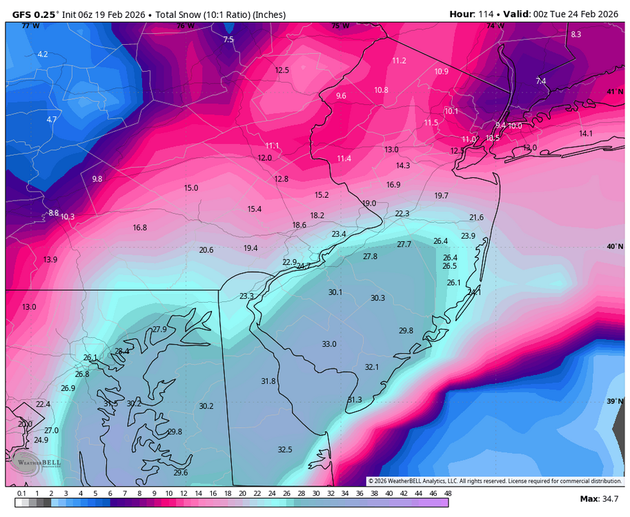
-
E PA/NJ/DE Winter 2025-26 Obs/Discussion
Newman replied to LVblizzard's topic in Philadelphia Region
6z GFS is the best run since the Canadian a few days ago. Wow! Tucks it right into the delmarva -
E PA/NJ/DE Winter 2025-26 Obs/Discussion
Newman replied to LVblizzard's topic in Philadelphia Region
These are excellent trends on the last 4 GEFS runs. We need to continue to see these ticks or at least a hold over the next day or two. A big thing is that ULL off the West Coast which needs to keep backing up off the coast to allow the downstream ridge to back west as well. More spacing between our 50/50 and East Coast trough too is a good look.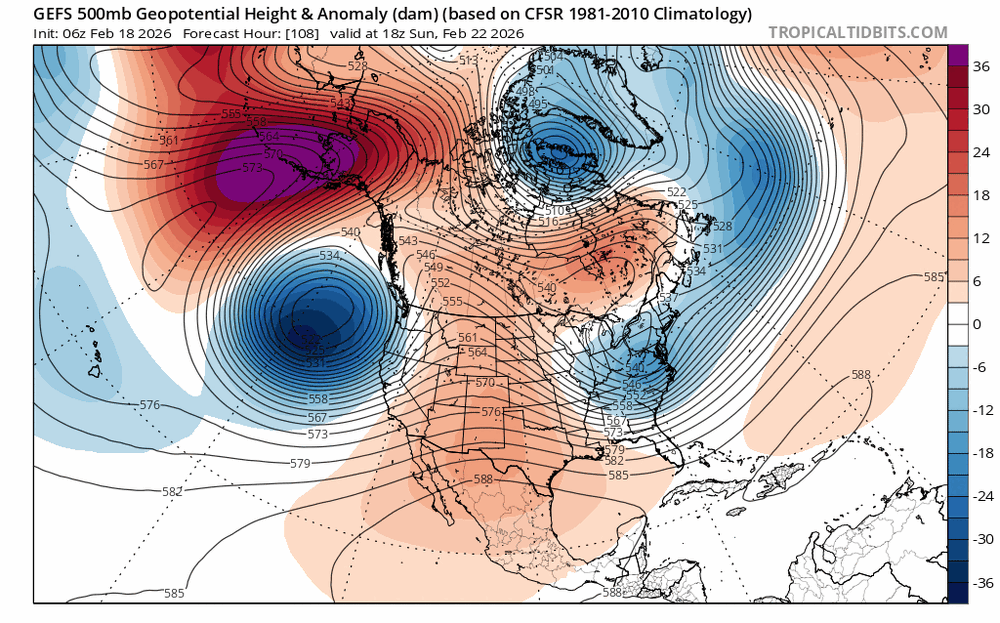
-
E PA/NJ/DE Winter 2025-26 Obs/Discussion
Newman replied to LVblizzard's topic in Philadelphia Region
I mean, even as is, much of SE PA gets a light 1-3" snow from the H5 pass on the Euro. I don't think there's a single model that is a complete whiff. -
E PA/NJ/DE Winter 2025-26 Obs/Discussion
Newman replied to LVblizzard's topic in Philadelphia Region
Last 4 run trend of the GEFS. Look at the western ridge, it continues to get more stout and back up further west. That'll allow our energy to dive into the country further west and allow more time for amplification. There's also more separation in general between the 50/50 and our coastal system.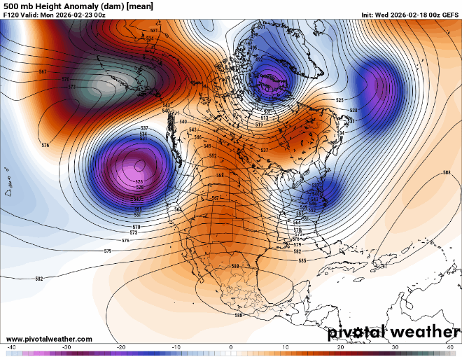
-
E PA/NJ/DE Winter 2025-26 Obs/Discussion
Newman replied to LVblizzard's topic in Philadelphia Region
The RGEM (and therefore the CMC) at 18z, and the GFS at 18z, both made additional improvements at H5. I swear the Euro will probably be down in the Bahamas in about an hour -
E PA/NJ/DE Winter 2025-26 Obs/Discussion
Newman replied to LVblizzard's topic in Philadelphia Region
Wow GFS much better, continues to bring better ticks on almost all facets for this storm. And "much better" is probably an understatement, ha. The Delmarva/Jersey coast gets absolutely destroyed on this run! -
E PA/NJ/DE Winter 2025-26 Obs/Discussion
Newman replied to LVblizzard's topic in Philadelphia Region
The 18z ICON is actually much better than 12z wrt the actual upper level low/vort closed off over the Ohio Valley. But what do you know... There's a confluent vorticity streamer trailing the 50/50 low, lingering over New England and keeping heights suppressed. Feel like we've heard that story before this winter one too many times. If we got that out of the way (i.e. improved wave spacing) that thing was coming up the coast. 18z RGEM, if extrapolated, would've been a banger -
E PA/NJ/DE Winter 2025-26 Obs/Discussion
Newman replied to LVblizzard's topic in Philadelphia Region
All it takes is toggling through the GFS, CMC, and Euro to see they all look wildly different. The Euro even looks different from the AIFS. There's just so much energy flying around, it'll take at least a day or two more to gain any sort of confidence. The GFS and CMC improved, the Euro got worse. We just need to see which way models trend. Any slight ticks towards the Euro is no good.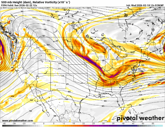
-
E PA/NJ/DE Winter 2025-26 Obs/Discussion
Newman replied to LVblizzard's topic in Philadelphia Region
Yep, the Euro went the wrong way with this and heights don't respond at all -
E PA/NJ/DE Winter 2025-26 Obs/Discussion
Newman replied to LVblizzard's topic in Philadelphia Region
Yeah Canadian is also much better. I don't like this setup because it's inherently volatile and dependent on getting the trough to tilt negative at just the right time. The ridge being through Montana and not Idaho could be the difference between a NW of I-95 storm or a SE of I-95 storm. Obviously lots of time to track and I think the entire subforum is still well in the game! -
E PA/NJ/DE Winter 2025-26 Obs/Discussion
Newman replied to LVblizzard's topic in Philadelphia Region
GFS is going to be significantly improved -
E PA/NJ/DE Winter 2025-26 Obs/Discussion
Newman replied to LVblizzard's topic in Philadelphia Region
I know models all shifted east overnight, which remains the fail mode, but we're not out of this by any means with lots of time left. We need to see improvements in the wave spacing between that system that exits CNE Friday/Saturday and our NS wave diving out of the Dakotas/MN. Pump the ridge more, inch it further west, and I think we can get that shortwave energy to round the trough enough for at least coastal areas. I'll be honest though, this setup now reminds me of last February's fail which ended up way suppressed and OTS. It has powder keg potential, but probably a lot lower probability from what we saw in previous days -
E PA/NJ/DE Winter 2025-26 Obs/Discussion
Newman replied to LVblizzard's topic in Philadelphia Region
I was literally going back in my images to look for that exact run What a fun storm that one was. For me personally down in Fleetwood, I enjoyed it more than 2016. We got more snow and, although rates never exceeded 2" an hour at peak, it snowed literally for days. -
E PA/NJ/DE Winter 2025-26 Obs/Discussion
Newman replied to LVblizzard's topic in Philadelphia Region
It reminds me of some of the wild RGEM/CMC OP runs from 2021 ha -
E PA/NJ/DE Winter 2025-26 Obs/Discussion
Newman replied to LVblizzard's topic in Philadelphia Region
This 96-132 hour range is where we've been at on a few occasions this winter, and ever since the beginning of weather tracking itself, that models begin to trend towards less favorable outcomes. I'd say 8 or even 9 times out of 10 when a MECS/HECS is seemingly looking likely, it falls apart in this specific hour range. It's all fun and games until the NAM is in range. There is no such thing as a rug pull at this point, we have so long to go. One of the more discouraging shifts in NWP in recent years has been the lack of confidence gained from some ensemble guidance. And what I mean is the EPS and GEFS tend to follow the OP or be incredibly underdispersive. Despite some gripes with them, the ensembles are truly our best form of guidance at this range if you know how to use them. These pretty snow maps from the deterministic models are fun to look at, but they're purely entertainment at this range. With that in mind, if you blend the EPS, Euro AIFS ENS, GEFS, and CMC Ens... You find that you're basically split 50/50 on a hit or miss. The good news? The EPS has been trending towards the big solutions. And the GEFS is just a bad model, so who cares lol. -
E PA/NJ/DE Winter 2025-26 Obs/Discussion
Newman replied to LVblizzard's topic in Philadelphia Region
Euro AI is east of 6z but still not bad for much of SE PA at all, widespread 6-12" with more along the Jersey coast. Well within the ensemble envelope at this range. -
E PA/NJ/DE Winter 2025-26 Obs/Discussion
Newman replied to LVblizzard's topic in Philadelphia Region
A pretty much perfect progression. Capture and stall off the Jersey coast, it occludes so you get snow right down to the LP center
-
E PA/NJ/DE Winter 2025-26 Obs/Discussion
Newman replied to LVblizzard's topic in Philadelphia Region
Holy shit CMC! -
E PA/NJ/DE Winter 2025-26 Obs/Discussion
Newman replied to LVblizzard's topic in Philadelphia Region
GFS just a bit too disjointed with phasing in that NS vort, verbatim it's still a huge hit for coastal Jersey. This 12z run is also completely different with how it handles that southern vort, it's amplitude, speed, etc. But I guess it goes to show that it's not a thread the needle scenario, we can score in different ways, though some locations will be favored depending on the final evolution. GFS being SE at this time though is classic, you wouldn't expect anything less. Actually looking at the final GFS solution, it's just a tad too late with fully phasing hence the strongest PVA is offshore and into Jersey -> NYC -> SNE