MAG5035
-
Posts
6,078 -
Joined
-
Last visited
Content Type
Profiles
Blogs
Forums
American Weather
Media Demo
Store
Gallery
Everything posted by MAG5035
-
Central PA Winter 25/26 Discussion and Obs
MAG5035 replied to MAG5035's topic in Upstate New York/Pennsylvania
Surprised no one posted this earlier, CTP bumped up amounts areawide. My point and click is up to 13-21 inches now.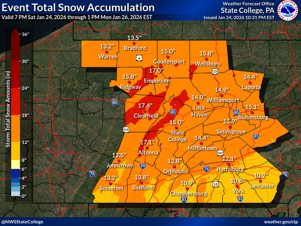
-
Central PA Winter 25/26 Discussion and Obs
MAG5035 replied to MAG5035's topic in Upstate New York/Pennsylvania
Snow began here just a bit after midnight, light for now. Temp 10ºF, Dewpoint 2ºF. Its happening! -
Central PA Winter 25/26 Discussion and Obs
MAG5035 replied to MAG5035's topic in Upstate New York/Pennsylvania
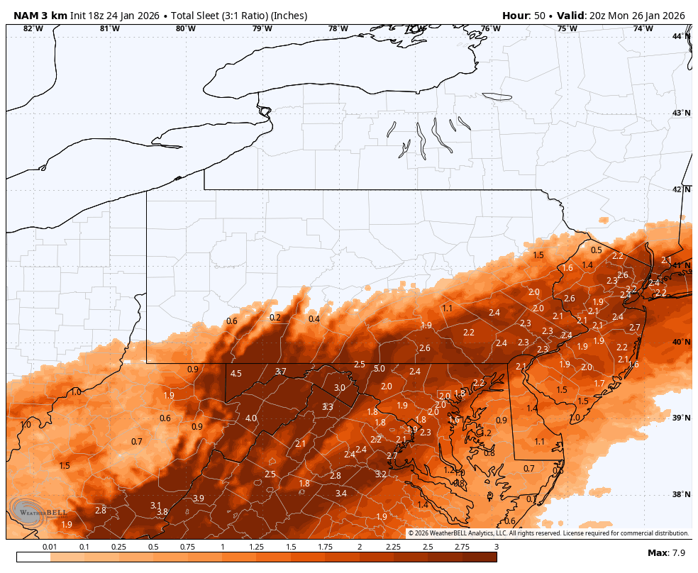
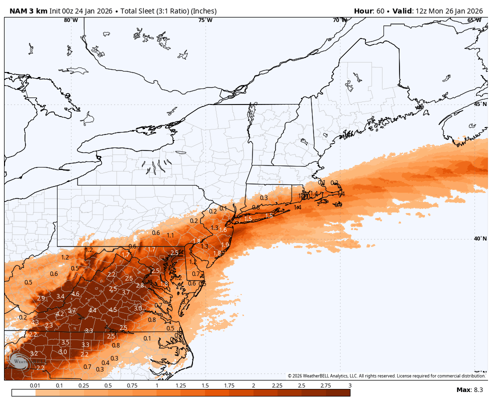
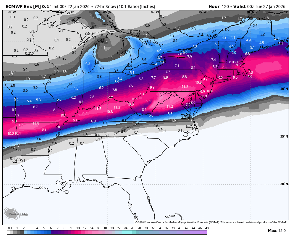
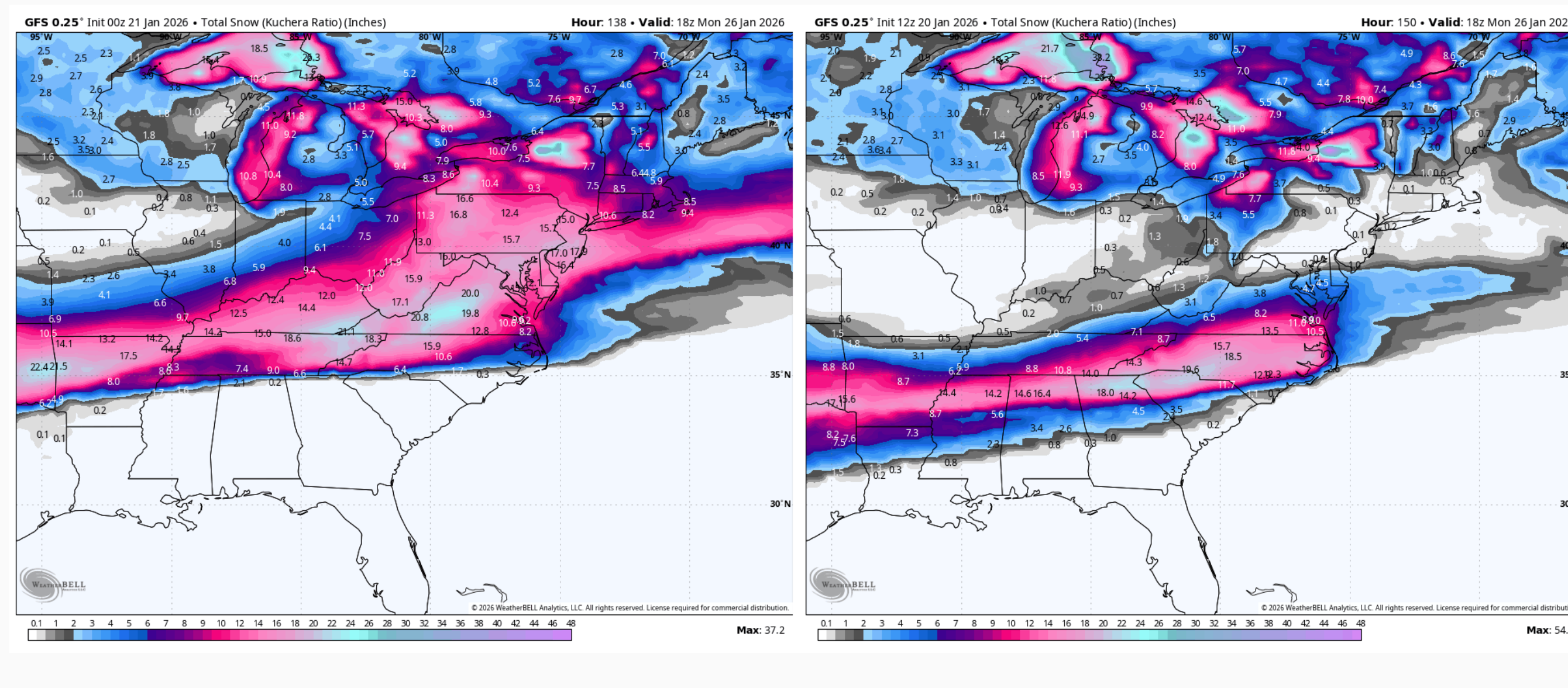
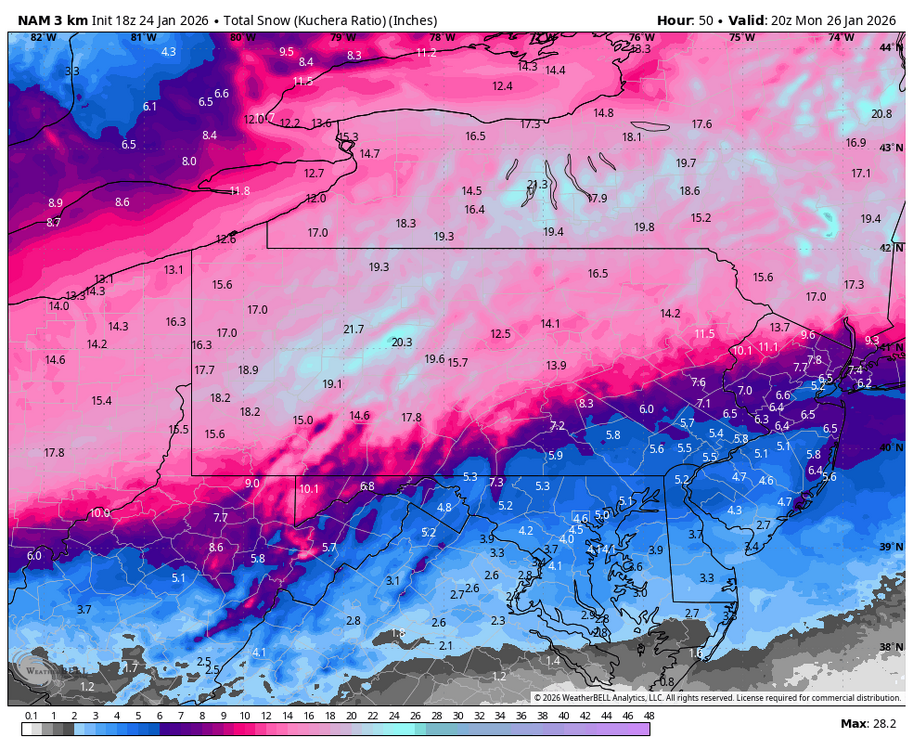
3k NAM does try to bring the snow line back down as the secondary starts to take over, which keeps places like JST and AOO pretty much mostly or all snow but it slots before it really drops back into the Sus Valley. At the same time this model is showing the best comma head over western and northern PA and is probably the snowiest run yet for the max snows, which is exceeding 20” on Kuchera in west central PA. Sleet is prolific in the far PA southern tier/LSV and well, just about everywhere else south of there. This is the kind of setup I feel there’s going to be a zone of multiple inches of sleet somewhere given the depth of the arctic air mass. That widespread? We’ll see. But that’s 2-3” of sleet on top of the 5-7” of snow it puts out in the LSV. Snowfall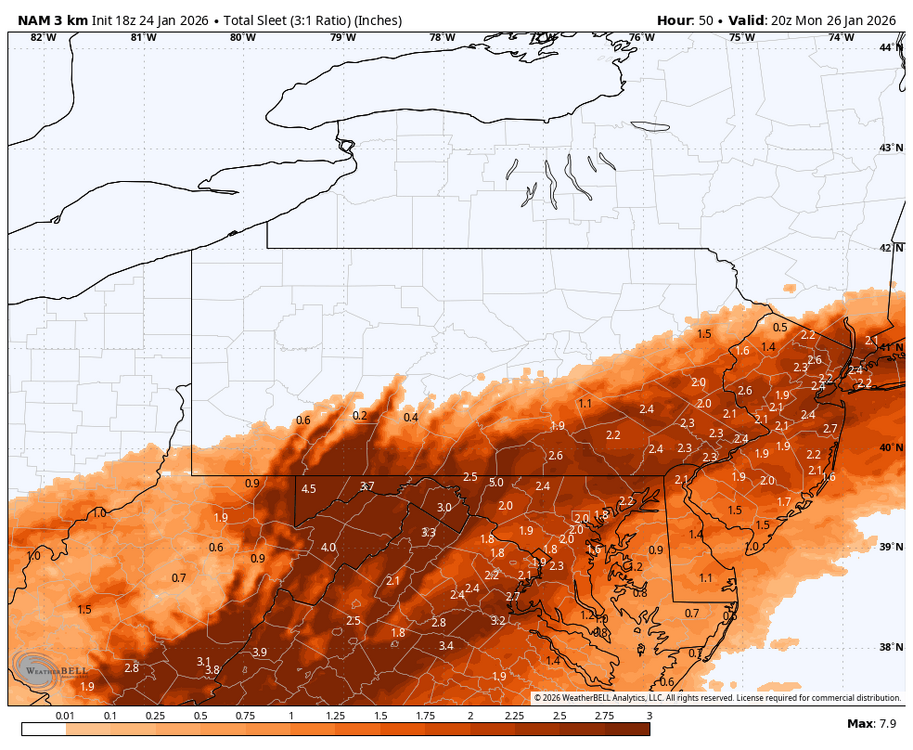
-
Central PA Winter 25/26 Discussion and Obs
MAG5035 replied to MAG5035's topic in Upstate New York/Pennsylvania
1st and probably only call I’m gonna do with this. I could’ve just put a text box that said 10-18” on it and called it a day and would’ve had the model support to defend it. But I am hedging some on the NAM thermals being at least partly right and a bit more sleet intrusion. Not full NAM, but somewhere in between that and the general consensus. These are purely snow numbers, obviously the reduced zones in the southern tier are for sleet mixing, but if that were to occur than sleet accumulations would be fairly notable as well (perhaps an inch or so). The only reason I’m giving the NAM a bit more weight in what is mainly a snowier consensus is strictly its handling of mid-level features and the warm nose. If the snowier consensus wins out, then the whole subforum simply sees 12-18”. Impact wise, that really isn’t that much of a difference.. this is going to be disruptive. I also think top end will be tempered a bit, mainly for speed of the system. Mostly I think there will be a lot of 14s and 15s with some 16-18” reports sprinkled in. It doesn’t look like any kind of a comma head lingers in C-PA to drive widespread amounts toward the 20” mark. What could overcome that is a fast start to the heavier snows when the best snow ratios will be before the mid-levels of the column start to warm later in the event. Both of these points were mentioned in CTP’s disco from yesterday.. which was a good informative discussion.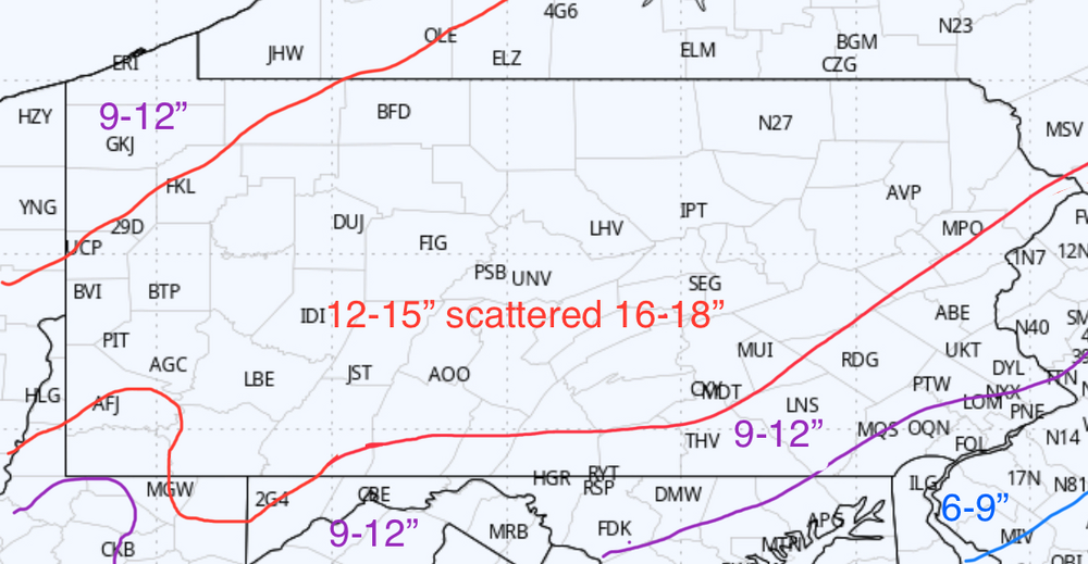
-
Central PA Winter 25/26 Discussion and Obs
MAG5035 replied to MAG5035's topic in Upstate New York/Pennsylvania
Oh yea here’s some current obs, it’s half a degree here right now. -
Central PA Winter 25/26 Discussion and Obs
MAG5035 replied to MAG5035's topic in Upstate New York/Pennsylvania
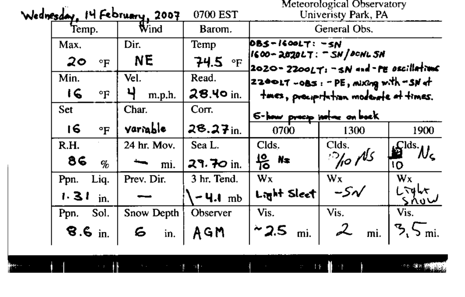
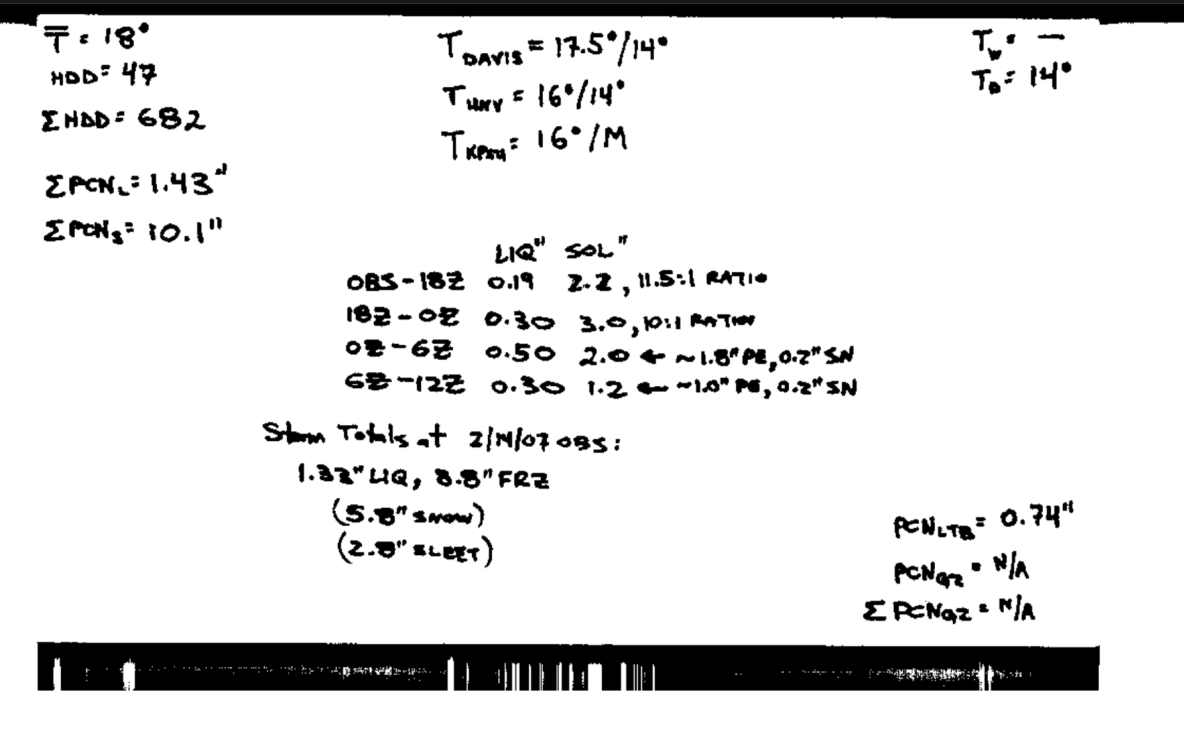
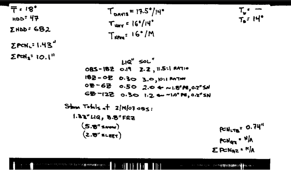
Back this way the PSU Walker Building noted 5.8” of snow and 2.8” of sleet on the observation card from that event, and then a further 1.8” of snow on the next day’s observation card. I do remember this storm made quite the glacier pack.
-
Central PA Winter 25/26 Discussion and Obs
MAG5035 replied to MAG5035's topic in Upstate New York/Pennsylvania
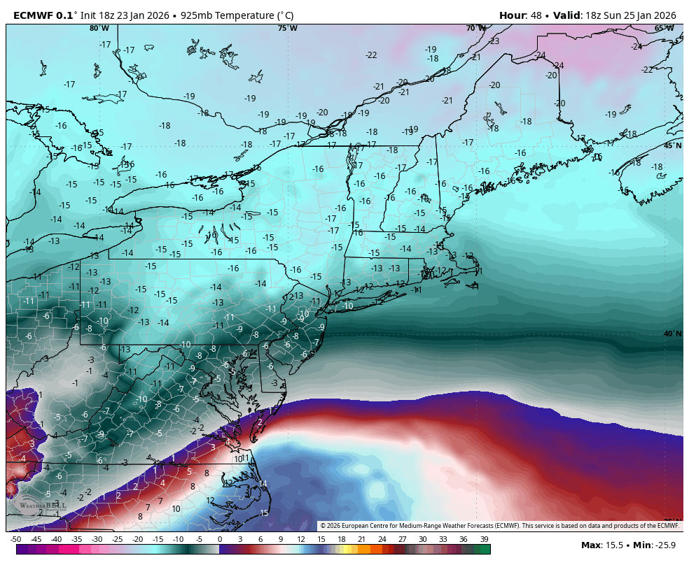
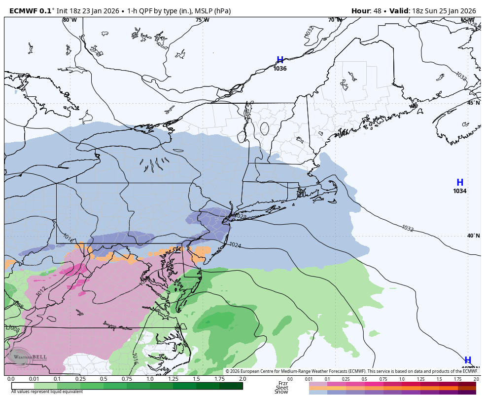
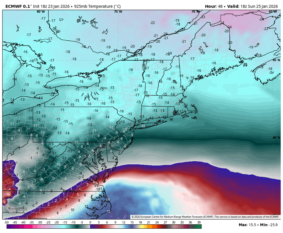
That’s about what the 3k NAM puts out for a large chunk of Virginia into the western Carolinas. Despite getting the mixing further north, it is by no means warm outside of that region near the 800mb level where above freezing air manages to advect in. Which actually brings up the haggling over details that I’m usually trying to sort out for our area, ice impacts. Let’s look down in the Mid-Atlantic region…I’m no fan of whatever algorithm the Euro uses to generate its p-types when it comes to sleet vs freezing rain. Instead of a sleet bomb, it pretty much encases the entire state of Virginia in about .75-1.00” of freezing rain. These two models have a pretty similar column thermally. Here’s Euro’s 925mb (3000 ft temps) Euro 1hr precip/ptype at the same frame That’s with surface temps in the low to mid 20s all the way down thru western NC and 850mb (5000ft) temps below zero in northern VA. No way am I buying that big of an expanse of crippling freezing rain on CAD of that strength and depth there outside of the Apps in the far western part of the state. A much more sleet heavy scenario, with an eventual transition to freezing rain late in the event seems more plausible. But yea those are two models with radically different ice scenarios despite similar column thermals. Applying this to our area, any mix type during the main part of this is going to be sleet. There’s just too much depth to the cold for anything appreciable freezing rain wise.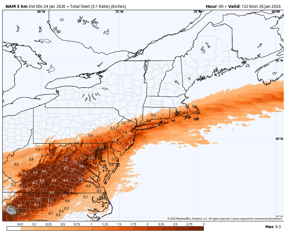

-
Central PA Winter 25/26 Discussion and Obs
MAG5035 replied to MAG5035's topic in Upstate New York/Pennsylvania
This storm has definitely sped up a bit both in onset time and ending time now that we’re getting into the near term forecasting of it, which is pretty common with these type of storms. It looks like the business end of this occurs in a bit under 24 hours now, arriving in the LSV approx 2-3am Sunday and starting to shut off midnight-1am or so Monday. -
Central PA Winter 25/26 Discussion and Obs
MAG5035 replied to MAG5035's topic in Upstate New York/Pennsylvania
I might do one. Think I at least want to see what the 0z suite offers up first. -
Central PA Winter 25/26 Discussion and Obs
MAG5035 replied to MAG5035's topic in Upstate New York/Pennsylvania
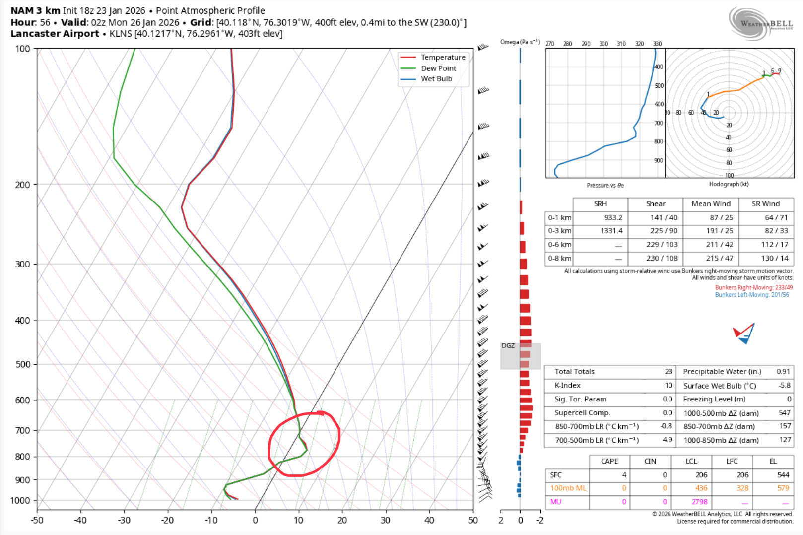
Now that this is finally into 3k NAM range we can have a look at the sounding to see what we’re dealing with in terms of warm air intrusion aloft. Sounding for LNS (Lancaster) at hour 56 As you can see, the warm air intrusion is pretty high, situated between the 850mb and 700mb layer. That’s why at first glance the 850 and 700 mb temp maps might look okay for an all snow column. Could it be too aggressive with the WAA at that level? Sure, but I’ll forewarn that this was the exact situation that sunk the significant snow in a lot of NE PA back on 12/26. NAM was about the only thing that caught that. And it doesn’t matter how cold it is at the surface. When you melt a falling a snowflake it doesn’t turn back into a snowflake when it refreezes. This is a different storm setup to be sure, and again.. there will be significant snows before any mixing where it happens. And sleet will be the predominant mix type given strength and depth of the arctic air mass.
-
Central PA Winter 25/26 Discussion and Obs
MAG5035 replied to MAG5035's topic in Upstate New York/Pennsylvania
Lol, certainly not in the 20”+ inch snowstorm department. It’s been since probably 1994 that one of those has happened here in the city itself. ‘96, ‘03, and ‘10 were all 16-18” events and Jan 2016, Dec 2020, and Feb 2021 were about a foot. -
Central PA Winter 25/26 Discussion and Obs
MAG5035 replied to MAG5035's topic in Upstate New York/Pennsylvania
GFS did get a tad NW with the snow/sleet line compared to its 18z run, getting into a portion of Lancaster and maybe extreme southern York. Still a plenty big enough hit for everyone. Top end down a slight bit area-wide, basically 18-19” (Kuchera) for everyone. -
Central PA Winter 25/26 Discussion and Obs
MAG5035 replied to MAG5035's topic in Upstate New York/Pennsylvania
I’m really torn between going with what I think or going low because it hasn’t been an official winter in here yet without the annual hotly debated lowball snow total measured at MDT. I’ll go 15.0” -
Central PA Winter 25/26 Discussion and Obs
MAG5035 replied to MAG5035's topic in Upstate New York/Pennsylvania
It has deeper mid level features that are further NW, particularly at 700mb..which is why the WAA at/near that level is so strong. It’s a viable scenario, the 12/26 storm is definitely on my mind here when it comes to the NAM but we’re not yet at the range that it even covers the whole storm so I’m not going to get wound up about it but I’m certainly going to see what other guidance does in the meantime. For all of us here this is likely a sleet vs snow scenario if there ends up being a mix type. Column probably holds the whole way up to about 800mb in a mixing scenario and the frigid surface temps probably aren’t going anywhere. Another thing to consider is if we hold all or mostly snow in the southern half of the state, there is still gonna be a good bit of WAA in the mid levels. If we end up somewhere in the spectrum between the GFS and the NAM that could eventually affect snow growth later in the event at the levels where some of the best lift will be and hence you end up with worse snow ratios even with how cold the surface will be. Kuchera only calculates off of the coldest temp in the layer and not the combo of where the best lift vs temp of that level is. So a 17-18:1 fluff bomb could turn into more of a standard climo 12-14:1 during some of the best part of the storm. Just laying out thoughts here, I’m pretty highly confident everyone easily gets warning snow in here and impacts are going to be major regardless. I feel like a 10-16” type snowfall area wide is a fairly prudent call right now with the acknowledgment that this could trend a little bit worse (more sleet) in the southern tier or better for everyone if something like the colder GFS came to fruition. -
Central PA Winter 25/26 Discussion and Obs
MAG5035 replied to MAG5035's topic in Upstate New York/Pennsylvania
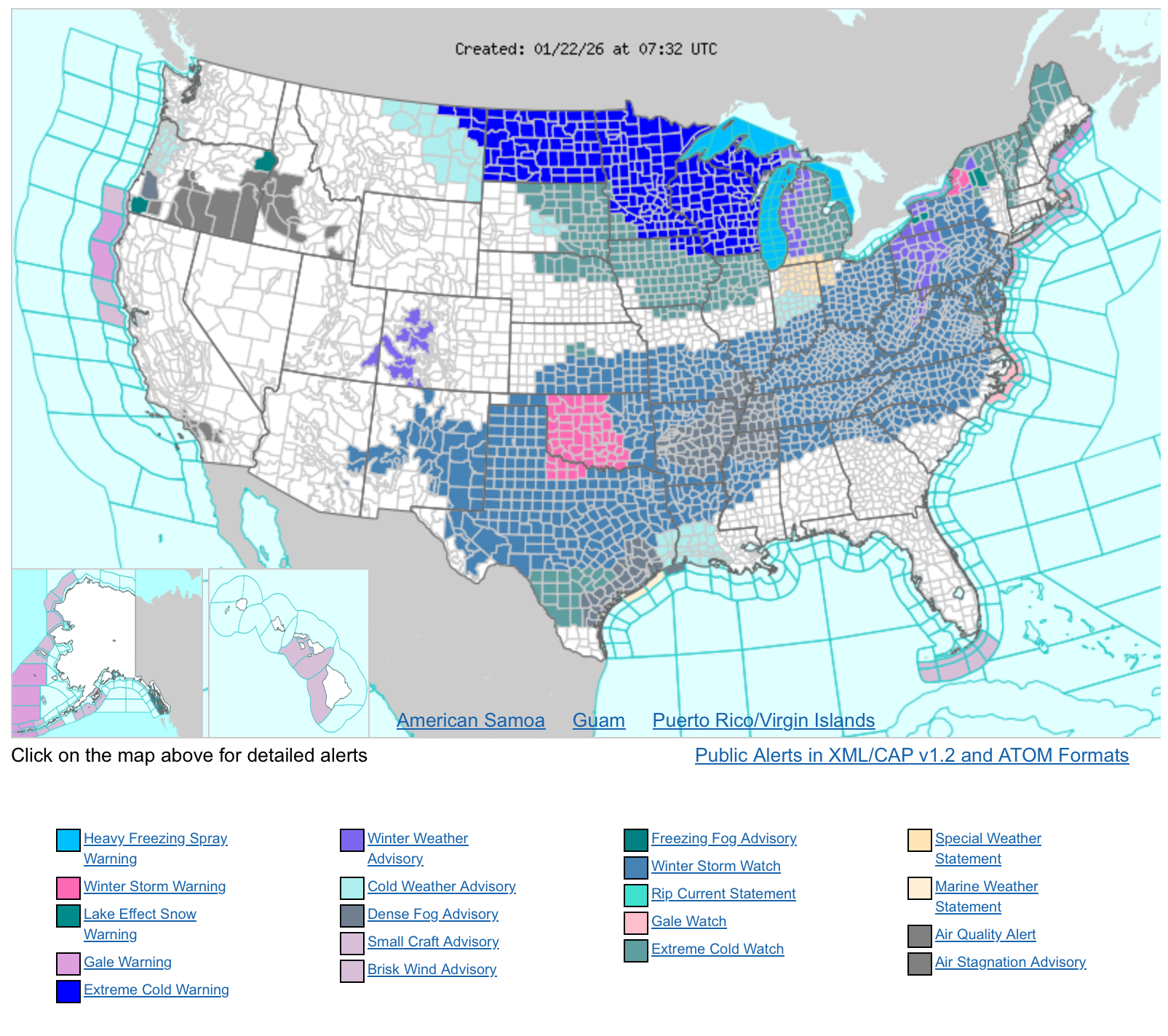
And wow, Winter storm watches up already for everywhere, literally. I don’t think I ever saw such a large expanse of watches.
-
Central PA Winter 25/26 Discussion and Obs
MAG5035 replied to MAG5035's topic in Upstate New York/Pennsylvania
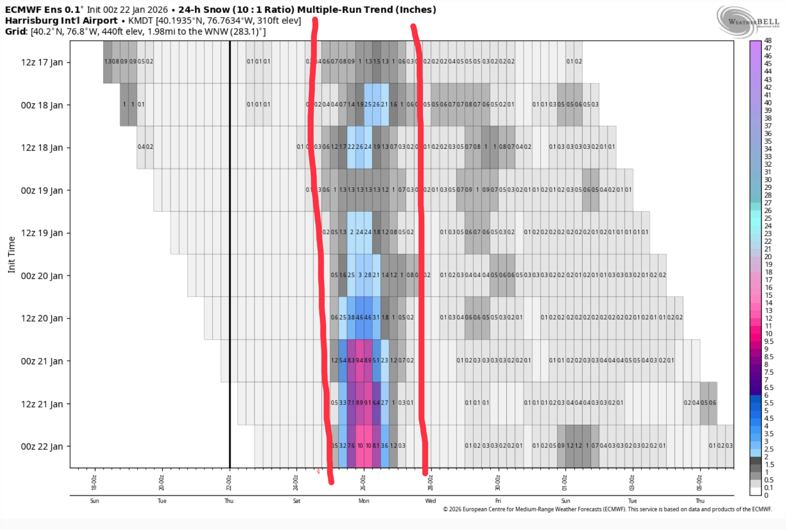
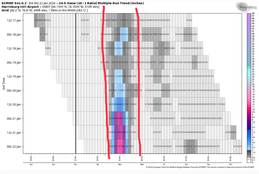
Looking over the 0z ensembles, they continue to be more supportive of an all snow outcome in all of C-PA despite the Euro and especially Canadian op creeping that mix line into southern PA. Here’s the Canadian ensemble members and p-type. Note that none of the members really intrude into PA with the mix line. A couple get close, but snow is predominant regardless. That factors pretty heavily into what your seeing on the NBM maps, as it blends all these ensembles. 0z Euro ensemble is fantastic Here’s the multi-run trend for MDT (Euro ensemble), you can see how this has really escalated the last couple days.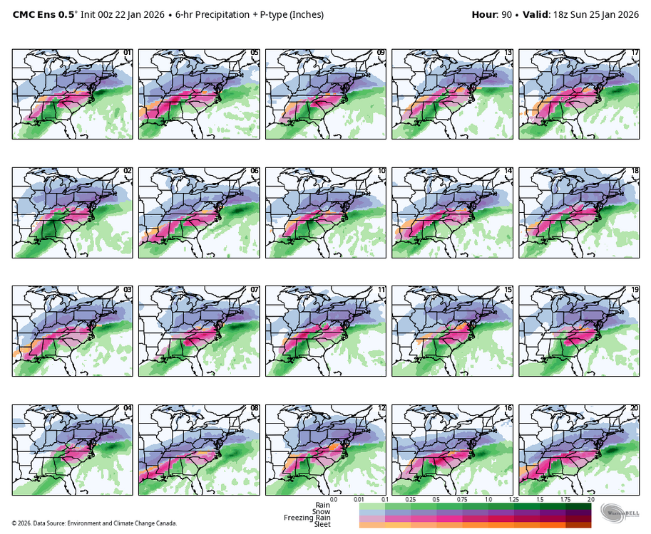

-
Central PA Winter 25/26 Discussion and Obs
MAG5035 replied to MAG5035's topic in Upstate New York/Pennsylvania
They can keep that data coming haha. It doesn’t get much better than that for a well timed and positioned handoff to the coastal low to put PA in the best snows. -
Central PA Winter 25/26 Discussion and Obs
MAG5035 replied to MAG5035's topic in Upstate New York/Pennsylvania
It does, I know reading into the updates of the new version that it mainly applies the Cobb method for snow ratios. I think the current version does to a degree as well, not sure. But the NBM snow maps do factor in variable ratios. -
Central PA Winter 25/26 Discussion and Obs
MAG5035 replied to MAG5035's topic in Upstate New York/Pennsylvania
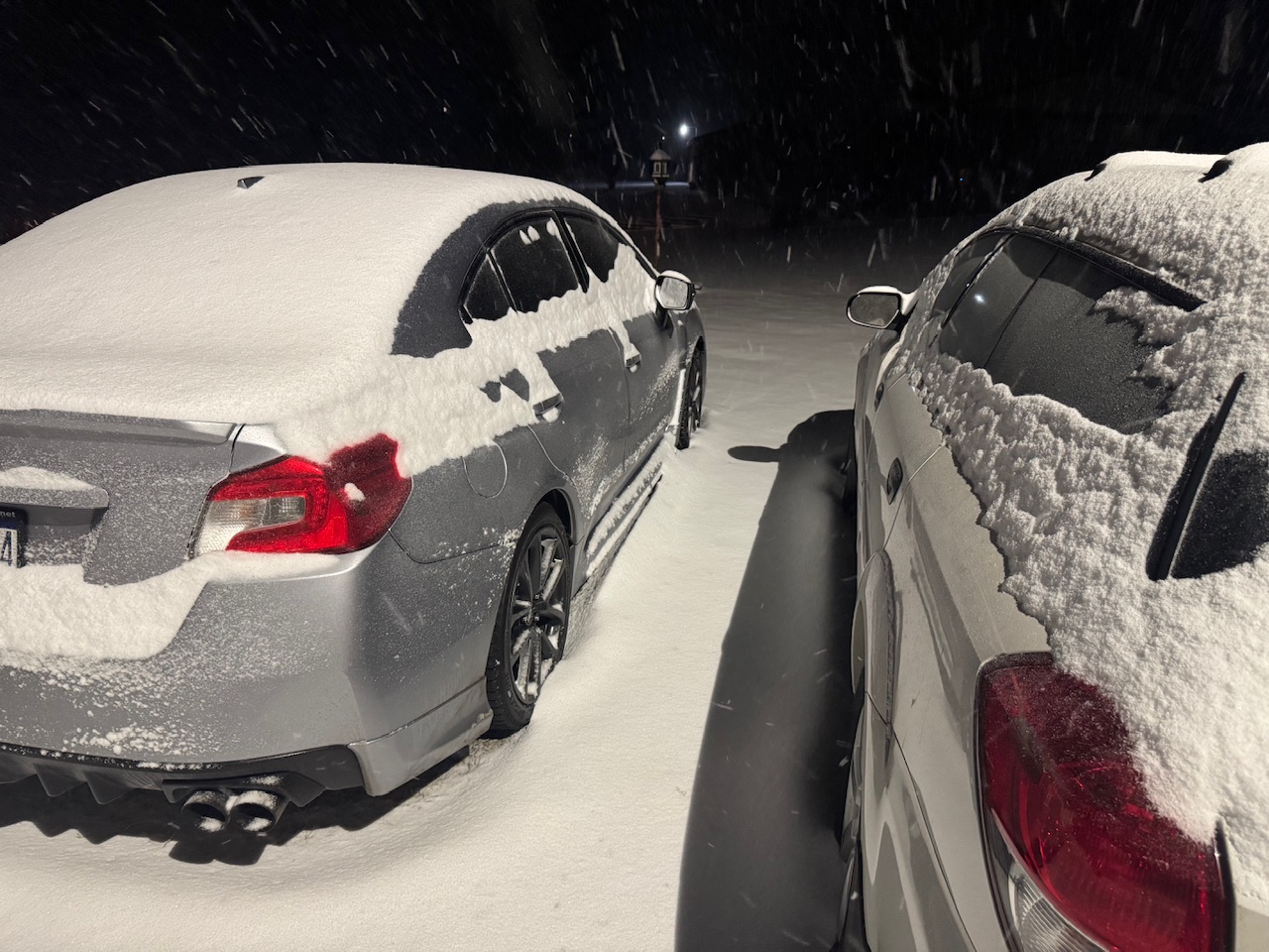
2.5” so far this evening here, what a nice surprise. Was down at our camp in NW Huntingdon Co earlier and about the same there as well. Roads are a mess.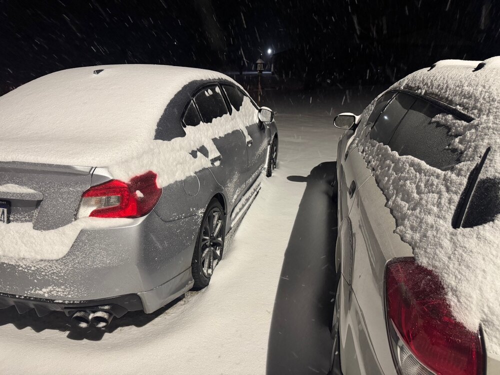
-
Central PA Winter 25/26 Discussion and Obs
MAG5035 replied to MAG5035's topic in Upstate New York/Pennsylvania
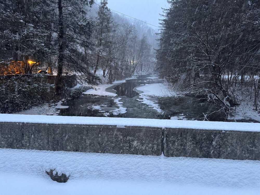
I’ve been busy enough watching the weekend that I missed being advised for 1-3” earlier this afternoon for tonight. Snowing sideways and 26ºF currently. -
Central PA Winter 25/26 Discussion and Obs
MAG5035 replied to MAG5035's topic in Upstate New York/Pennsylvania
Yea I mean I’m not going to argue his points, they’re valid. I’ve posted a couple times about his point #2 (western ridge alignment) the last couple days, why not air the skepticism he had when some guidance had this buried in the Carolinas as recently as yesterday at 12z? With that said, there’s only so much this storm is going to punch up into that cold air mass. It’s still fairly progressive in nature. Any PA mixing issues would likely be relegated to mainly sleet and not after a pretty large amount of snowfall. That strong of CAD isn’t going to get dislodged below 850mb by this. MDT is in the low teens for most of this event. -
Central PA Winter 25/26 Discussion and Obs
MAG5035 replied to MAG5035's topic in Upstate New York/Pennsylvania
Is he bailing on the first sign of a mix? haha -
Central PA Winter 25/26 Discussion and Obs
MAG5035 replied to MAG5035's topic in Upstate New York/Pennsylvania
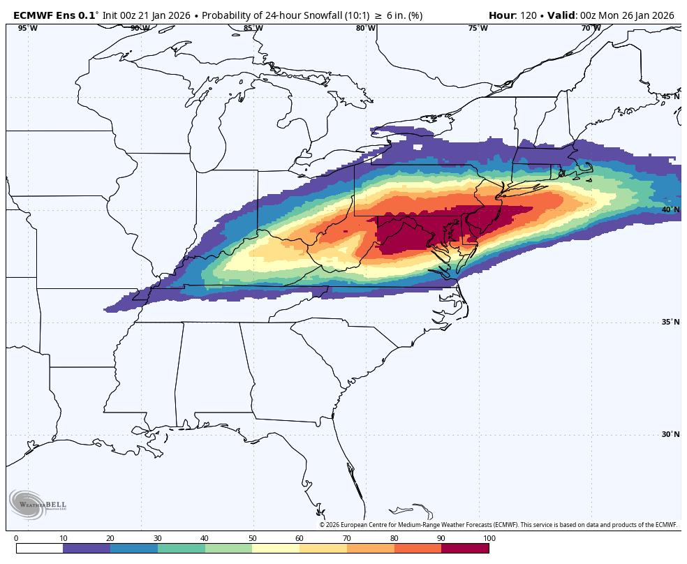
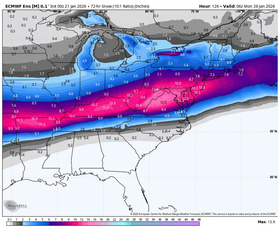
0z Euro ensembles continue to look better for heavier snows in PA, probs for 6”+ in a 24 hour period (at just the 10:1) are 80% or higher for about the southern third of the state now. 0z Euro ensemble snowfall mean
-
Central PA Winter 25/26 Discussion and Obs
MAG5035 replied to MAG5035's topic in Upstate New York/Pennsylvania
Possibly, I certainly think further down in VA may mix with this. I’ve not really sweated us missing out if the phasing scenario came to fruition, because of the pattern setup as I alluded to yesterday. 500mb ridge axis is west along the Pac Coast (classic for C-PA is Boise, ID ridge axis), height’s build in the SE US ahead of this system. Still relatively progressive though even with the phase, so I think that and the very anomalous cold air mass in place are what make this potential event go. A more typical cold airmass in place probably would have us under the gun for yet another messy winter storm that we’ve had too many of the last several years. Models have been more consistently showing some surface low reflection west of the Apps as well, which given the depth of the cold air mass and strong high pressure in place should be a good thing for us in terms of enhancing the snowfall across all of PA. Most of our classic big ones (96, 03, etc) have that signature. Comparison wise it’s tough, no storm is ever the same. Some shades of 2003, but that one didn’t have the prolific ice/snow zone the whole way back to Texas that this one’s forecast to have. The Baja low component of this reminds me of 2010, but this is a way colder setup and probably a weaker low that will keep moving. Antecedent cold air mass comparable to 1996 or even colder, but that was a much more amplified 500mb setup in the classic positioning. I personally don’t think the top end accum potential is going to get near any of those 3 in the Mid-Atlantic/PA but we’re not in NAM range yet haha. The overall impact and the sheer area of the US that is going to get significant snow/ice out of this though, is going to be biggest story with this. -
Central PA Winter 25/26 Discussion and Obs
MAG5035 replied to MAG5035's topic in Upstate New York/Pennsylvania
Crushed.. the difference between this run and the 12z today is hilarious.