MAG5035
-
Posts
6,078 -
Joined
-
Last visited
Content Type
Profiles
Blogs
Forums
American Weather
Media Demo
Store
Gallery
Everything posted by MAG5035
-
Central PA Winter 25/26 Discussion and Obs
MAG5035 replied to MAG5035's topic in Upstate New York/Pennsylvania
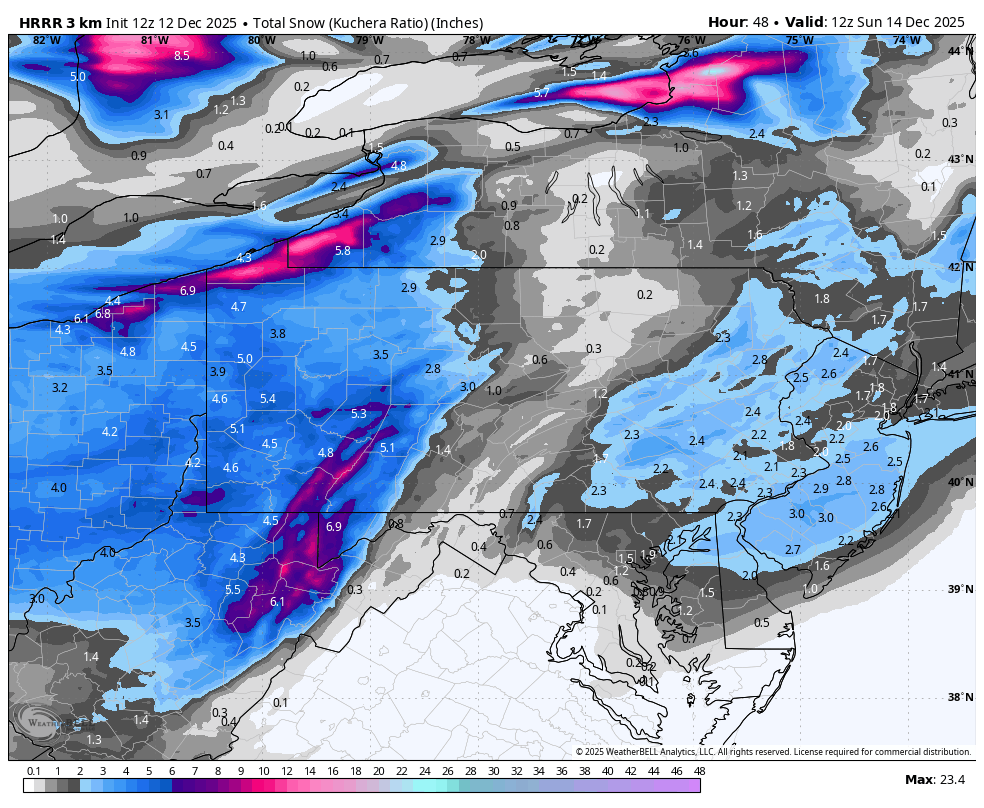
Might as well throw some accums out since this event is pretty close to starting in western PA. This is going to be a pretty big event in the western mountains. The western ridgelines of the Laurels may near double digits just from the event itself with the upslope flow and cold column (high ratios). Still going to be that corridor of reduced accums in the Ridge and Valley, although this has looked somewhat better as this has gotten into the realm of the near term guidance. I think most everyone will see at least an inch. That narrow corridor between the Allegheny front and I-99 may manage low end advisory amounts. Along with the somewhat better carry-over where the downsloping occurs, near term has also looked better in the Sus Valley for the precip shield reorganizing as the system gets to the coast and the column/surface cools further. Ratios won’t be as high as the Laurels, but it’ll still be pretty decent (perhaps as good as 14-15:1). The best precip coincides roughly with the -8ºC 850mb isotherm as it tracks across PA. It wouldn’t take much more QPF to make for a low end warning event in the Sus Valley. Western PA Pittsburgh metro and surrounding: 4-6” Washington: 5-7” Butler/Indiana: 3-5” Seven Springs: 6-10” (+ additional with LES and upslope after) Central PA Johnstown/Somerset: 4-7” (+ additional with LES and upslope after) Clearfield: 2-4” Altoona: 2-3” Bedford/State College: 1-2” Huntingdon/Lewistown/Williamsport: An inch or so Sus Valley Selinsgrove: 1-2” Gettysburg: 2-3” Harrisburg area/Tamaqua: 2-4” York/Lancaster: 2-4” (possibility of some 5”+ amounts) -
Central PA Winter 25/26 Discussion and Obs
MAG5035 replied to MAG5035's topic in Upstate New York/Pennsylvania
The HRRR is suggesting that right at the very beginning when it precip arrives into the LSV. I would think it would be brief if it happens. Surface starts above freezing but 850mb and 925mb level are plenty cold to start the event and cool further as the event progresses. I think this event should get the rest of the LSV solidly on the board in terms of first synoptic snowfall. -
Central PA Winter 25/26 Discussion and Obs
MAG5035 replied to MAG5035's topic in Upstate New York/Pennsylvania
Here was latest extended run of the HRRR (12z) this morning The biggest thing to resolve in C-PA with this system is the extent of the snow shadow east of the Alleghenies. Pretty much all modelling shows this now to varying degrees basically in between the I-99/US220 corridor and the I-81 corridor. Models like the GFS or the 3k NAM don’t even give much snow to a large portions of the Sus Valley. The wave itself is fast moving and very weak with not a lot of moisture to work with. The mean flow in the low levels remains westerly, which is why you see such a pronounced downsloping shadow off the Alleghenies on modelling. So unfortunately I expect this feature to show up with likely a corridor of T-1” snows in the ridge and valley. How fast that precip shield reenhances as the weak system reaches to the coast will dictate how much of the Sus Valley can reach at least a low end advisory type snowfall. I think York/Lancaster probably does okay, not sure about the Harrisburg area (right now I’m thinking about an inch maybe two in that area). Obviously western PA doesn’t have to worry about the downsloping component and that coupled with this being plenty cold with pretty high ratios it should be a pretty nice event over there. Given the aforementioned low level westerly flow, that will act as an upslope component on the western leading ridges of the Laurels, which is why you see those higher warning totals show up there.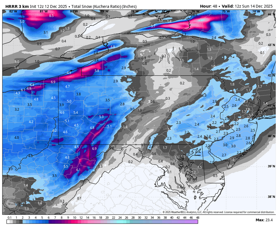
-
Central PA Winter 25/26 Discussion and Obs
MAG5035 replied to MAG5035's topic in Upstate New York/Pennsylvania
Thats quite a snow band, it’s actually reaching the whole way over through Lower Manhattan and Brooklyn in NYC where OKX has a special weather statement out for a dusting to an inch. -
Central PA Winter 25/26 Discussion and Obs
MAG5035 replied to MAG5035's topic in Upstate New York/Pennsylvania
It’s even more pronounced on the other globals. Especially on the GFS, which doesn’t have a snowflake make it east of I-99. GFS is probably on the far end of that side of the spectrum (and a bit further south with the wave as well), but that shadow off the Alleghenies is probably going to be a thing with this setup. The wave isn’t all that strong and doesn’t have much moisture to work with. Most modeling doesn’t have a closed surface low until this hits the coast, which is why the second snow swath shows up in SE PA and the DC to NYC 95 corridor. Otherwise the wave is running on a westerly flow, which downslopes off the east side of the Alleghenies. The 0z NAM had a more pronounced shortwave as it passes under PA, which made that about the only model to not have the shadow. Other modelling tonight 3z NBM (National Blend of Models) vs NBM v5. The v5 is an updated version of the NBM being tested ahead of being deployed April 2026. 0z Euro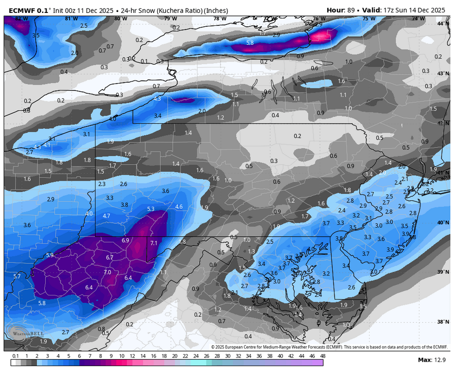
-
Central PA Winter 25/26 Discussion and Obs
MAG5035 replied to MAG5035's topic in Upstate New York/Pennsylvania
The EPO plays pretty big factor in this as well, surprised he doesn’t mention it. After it takes a major dip the rest of this week behind tomorrow’s system all ensembles have it reversing to a pretty positive regime by later next week getting into Christmas week, setting up the period where we may moderate. Ensembles do show the very persistent -WPO regime in a pretty classic representation of such with major ridging centered on the Bering Sea throughout. This helps establish cold continental source region of the airmass into Canada. In combo with a -EPO that’s a good recipe for dumping cold over most of the eastern 2/3s of the lower 48.. which is what we see coming up the next 6-10 days. EPO in its negative phase promotes more ridging into the west coast of the US up into Canada and Alaska, and a stronger jet/lower heights into the western US in its positive phase. It has high correlation to anomolous temps cold (negative) and warm (positive) in our neck of the woods. A split in the teleconnections with a -WPO/+EPO makes for a bit less certainty. If teleconnection forecasts are right with the switch to a solid +EPO we’ll have a good bit of Pac modified air injected into the pattern but also still plenty of cold in Canada. Another factor to pair with +EPO here is AO/NAO also being forecast to be positive, which implies lower heights nearer to the pole and a contraction of cold air press into the CONUS. So there is a pretty solid case for moderation here because while there is plenty of cold available in Canada this combo probably sets up a high zonal flow across the US. I don’t necessarily see us torching but I see it more as a detriment in terms of storm track (low track running north of PA) since we have had a northern branch dominated regime and next to no southern stream influence so far in the early going. It might still roughly reflect a P8 MJO regime in the temp department, but that alone doesn’t put the white gold on the ground. So we’ll see how that evolves, in the meantime we will continue to be cold for the next week or so with the opportunity for at least another light snow event or two, with the Saturday night/Sun wave showing the best promise. There won’t be much moisture associated but that particular wave will have pretty cold air set in place, and a couple of tenths of QPF could easily turn into a 2-5” type event. -
Central PA Winter 25/26 Discussion and Obs
MAG5035 replied to MAG5035's topic in Upstate New York/Pennsylvania
Temps have fallen all the way back to 9ºF here so far tonight, with some more room to fall further with a 5ºF dewpoint. KBFD already has another below zero night (-4ºF) currently, which makes two of those within only the first 8 days of December there. Even being generally the coldest official station in PA that’s still pretty impressive. -
Central PA Fall Discussions and Obs
MAG5035 replied to ChescoWx's topic in Upstate New York/Pennsylvania
I can’t believe no one’s made a winter thread yet, we’re 8 days into meteorological winter and we had a day last week where CONUS snow coverage for this time in December was the highest (45%) since 2005 plus our snow event last Tuesday and now the second snow event for VA going on today. So I’m going for it https://www.americanwx.com/bb/topic/62436-central-pa-winter-2526-discussion-and-obs/ -
We have a couple potential events this week. A potent shortwave traversing the Great Lakes Wednesday and another potential wave(s) over the weekend. The low on Wednesday passes north of PA, which will likely focus snow potential in northern PA and the Laurels with downsloping off of the mountains and probably surface temp issues. Another period of significant LES/upslope likely ensues in the aforementioned focus area of snow potential after the passage of the low. More pieces of energy along this fast northern branch dominated flow are in the pipeline behind this, with all major models at 12z today focusing more towards Sunday for a more notable wave traversing PA with a widespread snowfall. Much colder air looks to be in PA for this weekend vs Wednesday. Still some potential light snowfall Friday night as well showing on the Euro. All these waves will be enforcing a continued regime of much below normal temperatures.
-
Central PA Fall Discussions and Obs
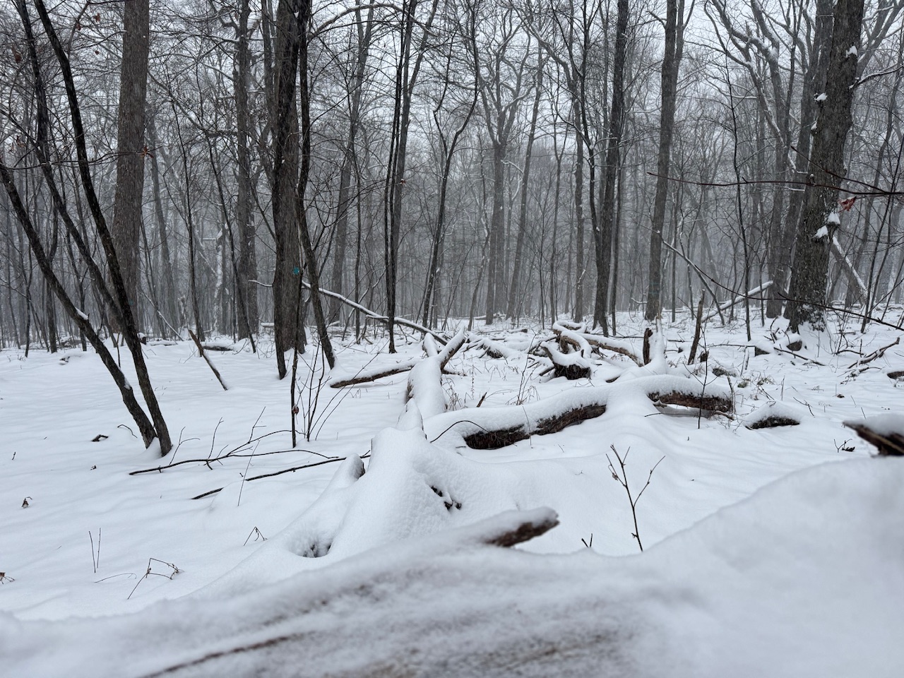
MAG5035 replied to ChescoWx's topic in Upstate New York/Pennsylvania
Probably at least 4” up on Tussey Mountain (approx 10 miles south of State College), although not completely sure since i didn’t bring anything with me to measure. Right at the 3” mark at home, and similar here at camp off the mountain. Almost at the end of the precip, definitely a nice morning overall. Now to get a system that does this for another 18 hours or so haha.

-
Central PA Fall Discussions and Obs
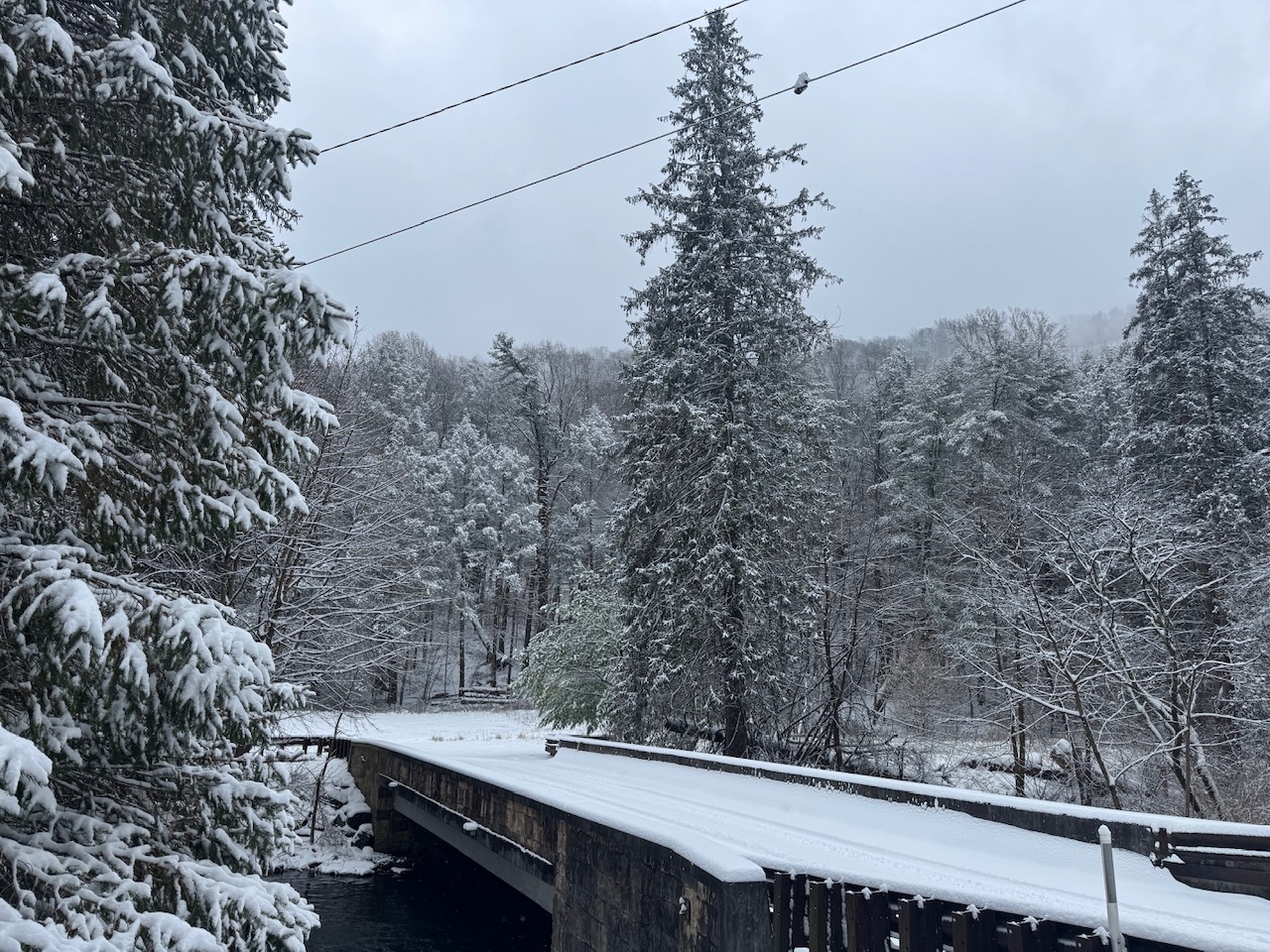
MAG5035 replied to ChescoWx's topic in Upstate New York/Pennsylvania
Already looks to be about 1.5” here and snowing pretty good. I’m at hunting camp over in Spruce Creek (NW Huntingdon Co). Looks similar at home, temp is 28ºF. -
Central PA Fall Discussions and Obs
MAG5035 replied to ChescoWx's topic in Upstate New York/Pennsylvania
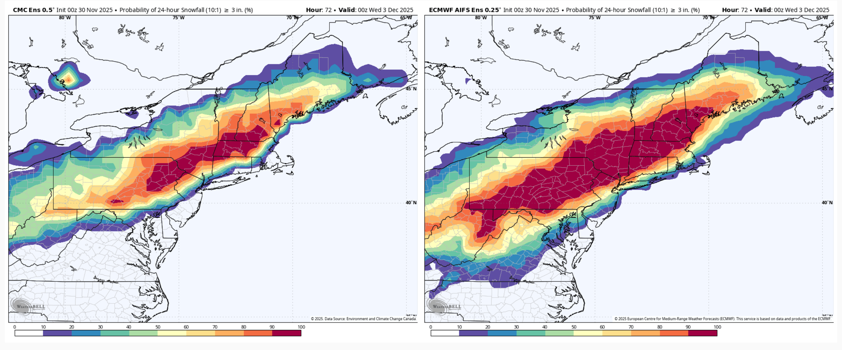
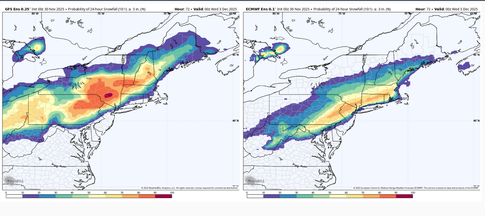
Overviewing all the model/ensemble stuff the last few runs I would think most if not all the subforum is looking good for the first widespread synoptic snowfall of the early winter season. I’m not really concerned about any P-type issues except for the LSV near the MD line, and even there I think there’s a good chance of advisory type snowfall or even a mostly snow event presuming we don’t trend the surface low NW much in the next 36 hrs. Think the ceiling in our area is likely to be 5-6” but mostly a 3-5” type event. Main issues I see to sort out at the moment is axis and width of the swath of heaviest snowfall. The regular Euro suite has been a bit more disjointed upstream developing the shield of precip. It seems to be the most progressive of the major stuff to include the GFS and Canadian suites, as well as the AI Euro. This makes for a late blossom of the precip shield over the majority of C-PA and a more focused swath as the coastal low deepens and moves NE. Basically everyone still sees snow but it’s a lot more 1-2” or so with a tighter swath of 3-5” type amounts… which is the furthest SE with that getting a couple inches all the way into DC. It’s reflective in the associated ensembles too. Might as well show them all. 0z GEFS vs Euro EPS 24hr probs of 3”+ 0z Canadian ensemble vs Euro AI ensemble for 24hr 3”+ probs, actually a pretty good match on swath axis The other end of the spectrum is the 3 and 12km NAM being the furthest NW, most wound up solution (no surprise) still as of 6z this morning. I’m sure thats the type of solution the MU guy is envisioning as the end game of what this system does in terms of the boundary being north. Which is certainly possible but I don’t see the amp in the pattern to bend this up in a Chesapeake Bay to NYC to Southern New England trajectory as deep as it has the low developing. And honestly that’s about the only kind of track I would entertain detrimental p-type issues reaching far up into southern PA and the Sus Valley. Otherwise I think this pattern setup we’re in is plenty cold enough to overcome early season climo. Yea the ridge axis is just off the Pacific Coast, but the PV is also anchored over Hudson Bay. Look at the 500mb anomalies for storm time. The only detriment of a +NAO in this setup would be a progessive pattern.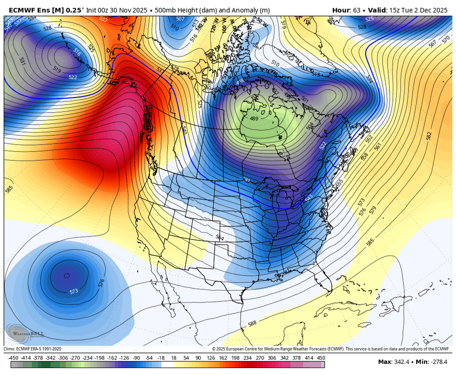

-
Central PA Fall Discussions and Obs
MAG5035 replied to ChescoWx's topic in Upstate New York/Pennsylvania
OK, I’m in. That pattern next week has evolved into something much more favorable on modelling the last few days since my last post. Gone is dumping the trough in the west and building southeast ridging. Instead, we’re bringing the energy for what is now Sunday’s system out quicker. While that low still cuts, the faster timing and fairly weak low invites a potential light snowfall/mix event in at least interior C-PA with some cold air still in place. So that’s actually the first thing I’m looking at with this period. That system resets the boundary, and we have a nice placement of the PV over Hudson Bay to help push down any semblance of SE ridging and we’re set for this Tues-Wed system that is looking way more wintry than it did several days ago. GFS is obviously a big and widespread snowstorm for a lot of folks. The Euro and Euro Ensemble are in fact showing this system as well. 0z Euro had the widespread precip but a more confined snow area, 6z Euro was shaping to look pretty decent but ran out of hours. Euro GPT doesn’t have it at all and those ensembles are weakly hinting at the system. Key will be a balance of amping this system up enough and placing/strength of the high to the north to set up cold and a more widespread snow swath. The feature itself looks progressive (no closed 500mb low or neg tilted trough) but low originates in the Gulf, so moisture source is there. -
Central PA Fall Discussions and Obs
MAG5035 replied to ChescoWx's topic in Upstate New York/Pennsylvania
Think there’s still a bit of work to be done for setting us up for the first widespread winter event of the early season. Cold shot Thanksgiving into the weekend has looked more transient with troughing dumping into the western US to set up the first half of the week following Thanksgiving. Allows for heights to more quickly rebuild in the eastern US with moderating temps by the time Sun/Mon roll around. Think any system in that timeframe of the first half of the week opening up December probably cuts. Teleconnection situation on models/ensembles shows developing -WPO/-EPO, good for sending cold air down thru Canada into the US. Countering is a generally +NAO and eventually -PNA, which will allow for SE ridging to try to edge up in the eastern US, at least initially. The -EPO/-WPO regime looks to have some staying power, so I think as long as we maintain that we can eventually work more consistent cold eastward and press the storm boundary down. Just looks like this is initially going to start in the west. Obviously still a pretty long lead time right now. Overall I’m pretty optimistic for things in December right now. At any rate, the Thanksgiving cold shot is still fairly potent. Perhaps not anything historic by any means, but definitely cold with temp departures of -8 to -10ºF looking like a pretty good bet area-wide Thanksgiving thru about Saturday or so. LES potential in PA doesn’t look as significant as the previous couple bouts of it we’ve had the last couple weeks that reached deeper into C-PA. Flow in the wake of the system that ushers the cold looks generally more WNW, which would keep more persistent LES more bottled up in the favored NW PA snow belt with focus being there and in western NY below Buffalo. Could be more of an opportunity of the usual snow showers reaching further into PA on Black Friday as the flow veers more NW briefly before heights start to build and shut off the flow. -
Central PA Fall Discussions and Obs
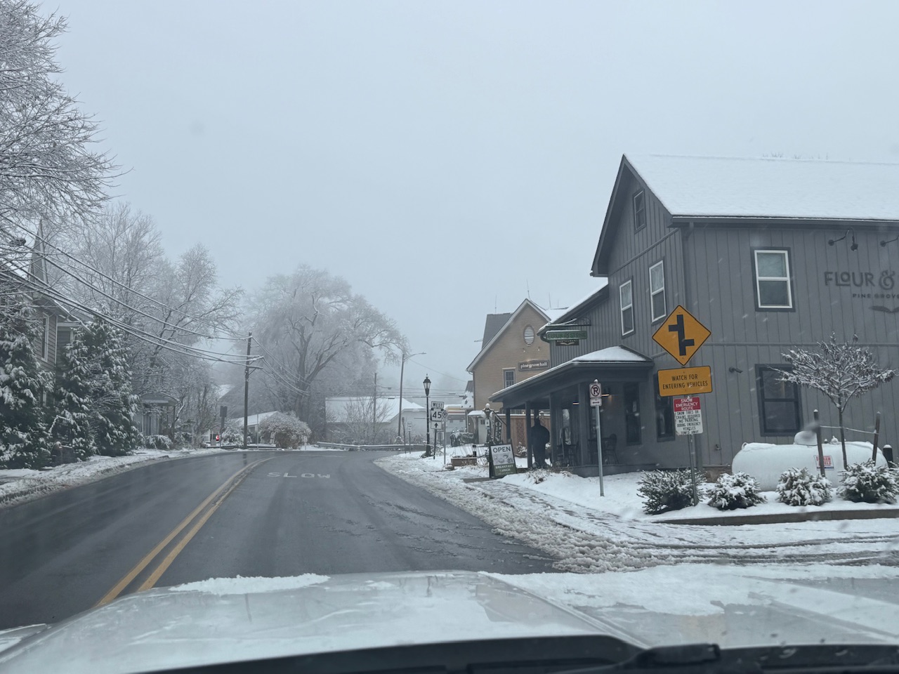
MAG5035 replied to ChescoWx's topic in Upstate New York/Pennsylvania
I was up in State College early this morning, and it was a general 1-2” or so up there. A legitimate plowable snowfall in some parts of town and the surrounding area up there. Good thing this didn’t occur a few hours later than it did, as P-Dot was able to get on it before the morning rush. Pine Grove Mills a few miles from State College
-
Central PA Fall Discussions and Obs
MAG5035 replied to ChescoWx's topic in Upstate New York/Pennsylvania
I just woke up right as this was ending here and have a half inch on the ground and slushy roads. Def a bit of a surprise as it was only supposed to be maybe a rain/snow mix here at best. Can see snow or snowing on the 511 cams down to at least Mifflintown. At any rate on the board with the first measurable of the new season here. -
Central PA Fall Discussions and Obs
MAG5035 replied to ChescoWx's topic in Upstate New York/Pennsylvania
I figure this is a good time to post for the first time in a good while. I’ve been very busy all summer and fall, but I’ll be getting back to posting regularly again now that we’re heading into the winter. At any rate first flakes of the season arrived here today. Nothing on the ground though here at the house, at least so far. Very potent snowband has been working the I-80 corridor from about Dubois to Clearfield and now stretching into Centre County and the Bellefonte/State College area. Of particular note is the stretch of I-80 from Dubois (Exit 97) to about the Penfield exit (Exit 111). Looks to be traffic issues there, especially east bound. This band is Huron connected as well, which is enhancing it further. I’ll bet some spots end up with up to 3”, perhaps even a bit more where the heaviest part of the band has trained the most.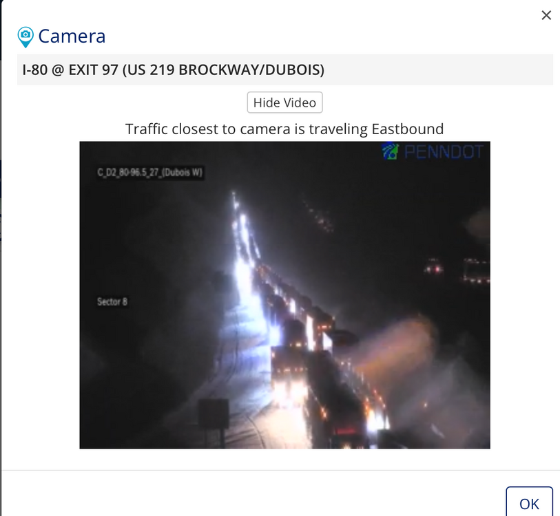
-
Stayed in it and finished the full mow of my house and the neighbors with this bearing down. Worst of this missed here to the west as this is riding up through Cambria and Clearfield with yet another tornado warning in Clearfield. Likely to cause more issues there I’m sure for the many folks in and around there that still don’t have power from Tuesday.
-
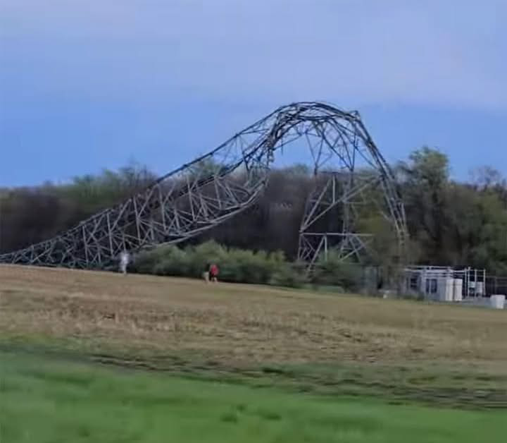
There hasn’t been much major severe to write home about in this part of Central PA for what seems like the last several years but this year has definitely been off to a wild start. Prior to yesterday there was a widespread severe event on 3/16 that really impacted some of the same areas with a few NWS confirmed tornadoes and lots of straight line wind damage in the I-80 corridor as well as the 99 corridor too. That one really hit Bellefonte and surrounding hard. Last nights line really hit a bit further south.. getting Cambria/Blair/southern Centre/Huntingdon coming in from western PA where it had its largest impacts in and around Pittsburgh. Carrolltown in Cambria County had the most notable damage report, with a cell phone tower being destroyed by the winds. Something you don’t see often outside hurricanes or maybe direct hits from tornadoes. The NWS reportedly surveyed this today and reported that to be straight line wind damage of 110-120mph winds. https://www.wtaj.com/weather/nws-survey-confirms-straight-line-wind-damage-in-cambria-county/ There was other widespread issues around here and tens of thousands of folks without power. I was out here for a couple hours and my parents up the road didn’t get theirs back until earlier today. No damage here at home fortunately.
-
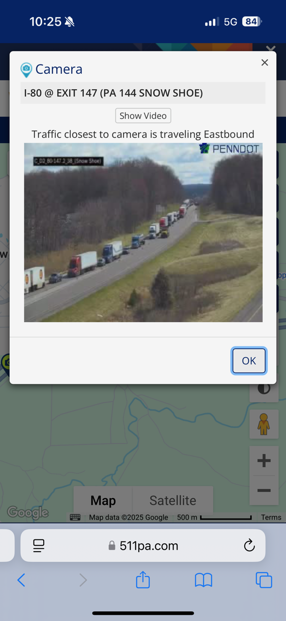
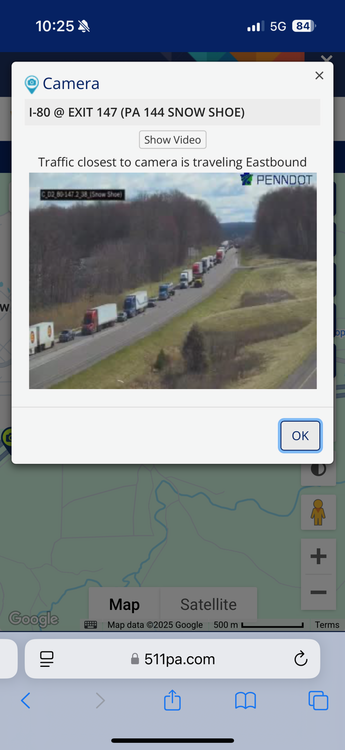
I-80 closed this morning between Kylertown (132) and Snow Shoe (147) from the snow squalls earlier this morning. Reportedly a 30+ pileup.
-
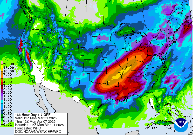
Pretty active pattern setting up this week in terms of multiple opportunities for rainfall, so hopefully can start chipping away at the established drought conditions in the SE part of the state. Despite that, the focus of the heaviest QPF is squared in the Ohio and Mid Mississippi Valley. Significant flooding appears a pretty good possibility there. Those are some pretty prolific QPF numbers in the bullseye, even over a 7 day period.
-
If I’m being honest the politics getting into the discussion was about the only thing in here that really made me feel any kind of way as far as getting heated. Not because it was brought up or necessarily from the differences in opinion but simply because the topic was beyond having a reasonable discussion, which obviously is a thing that goes way beyond the small confines of our subforum. I’ll refrain from rehashing further on that. Otherwise I feel the “discourse” in here is fairly tame compared to some of the stuff that occasionally flares up in the bigger subforums IMO. It’s obviously anyone’s choice whether they want or need to step aside and take a break and such, but I certainly don’t feel it’s necessary for anyone in here to do so from anything that’s been said recently. Hope everything works out for you.
-
KUNV had a peak gust of 64 mph, KJST 63mph.
-
Power has now gone out after the fact. At least a couple trees came down in the woods around my parents house up the road in Bellwood.
-
The wind part was quick but it was legit. Power flashed off at the height of the winds so unsure of the gusts, but definitely was easily of the severe variety. Had some pea sized hail as well.