MAG5035
Meteorologist-
Posts
6,078 -
Joined
-
Last visited
Content Type
Profiles
Blogs
Forums
American Weather
Media Demo
Store
Gallery
Everything posted by MAG5035
-
Central PA Winter 25/26 Discussion and Obs
MAG5035 replied to MAG5035's topic in Upstate New York/Pennsylvania
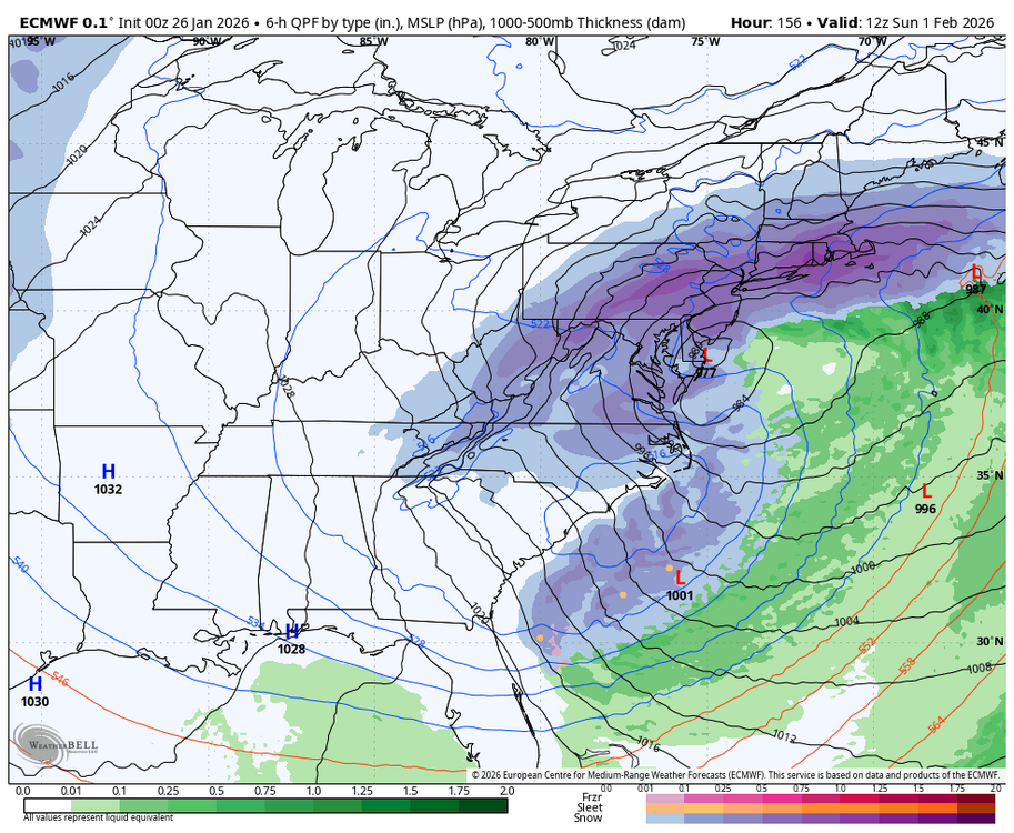
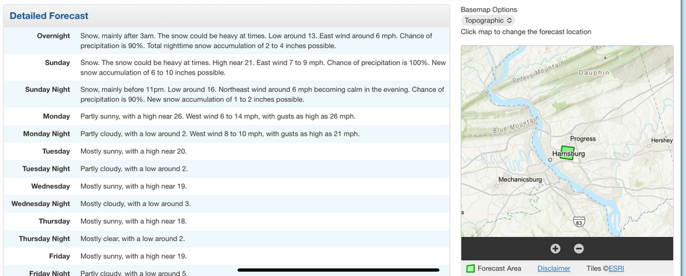
I mean I’ll gladly be wrong haha, though I didn’t completely shut the door on precip making it into southern PA. The 0z GFS is going harder than the 18z did, with a warning event in the Sus Valley and advisory all the way up through the C-PA I-80 counties. The northern feature is notably sharper and more involved than the 12z and 18z run. 0z vs 12z Models like the NAM and RGEM which hadn’t been anywhere near getting anything into PA now have lighter precip into the southern third of PA on the 0z run, although p-type is mainly rain with those models. 18z Euro, which was one of the few that got precip into PA was the same as well being similar in precip coverage to 12z but more rain. So temps are still a potential issue as they will be fairly mild Sunday. The GFS’s stronger solution would likely take care of that problem as that solution obviously has the heavier rates. You can see how a lighter event might still have issues though with the marginal surface temps. We’ll see what happens the next couple runs. -
Central PA Winter 25/26 Discussion and Obs
MAG5035 replied to MAG5035's topic in Upstate New York/Pennsylvania
I’ve given it a couple days but I do believe this Sunday storm possibility is pretty much cooked for us. The streams look to stay separate and this southern stream wave looks to shoot straight out under us. Still a possibility precip gets into the southern tier below the turnpike, as the op Euro and GFS still suggest but other guidance doesn’t get anything into PA. Some EPS support for the Euro op with measureable snow into PA while the NBM has virtually no swath of snow now.. as GEFS, Canadian ensemble and short term guidance like the NAM et al don’t get precip into PA. AI Euro an outlier showing a more substantial snowfall in the Sus Valley and warning amounts in Philly/NJ. Overall, it’s something I’d put at like 20-30% for a chance of a period of lighter snow in places like Gettysburg-York-Lancaster. Other issue in the event we get precip into southern PA could be temps. They look to top out near 40 Sunday and then likely only cool to around freezing during the timeframe of any impacts of the storm. P-type should be snow as I think the column would cool enough but I think surface temps would make any impacts (roads, non snow surfaces) minor. -
Central PA Winter 25/26 Discussion and Obs
MAG5035 replied to MAG5035's topic in Upstate New York/Pennsylvania
Nice day with 48ºF here currently. Some melting but dewpoint’s around 30 and it’s not all that windy today. Eastern PA holding onto chillier temps as progged, while temps did overachieve in the central and western parts of the state today. SW PA is way into the 50s. I see a lot of guidance the last couple runs are killing the storm threat for the weekend taking it way south, but I’m gonna remain indifferent to that prospect for now. Sure it could happen, but we’re also currently in that time range where models like to do such things for whatever reason. We went through a good bit of this with the 1/25 storm as well. So I’m not writing anything off yet. -
Central PA Winter 25/26 Discussion and Obs
MAG5035 replied to MAG5035's topic in Upstate New York/Pennsylvania
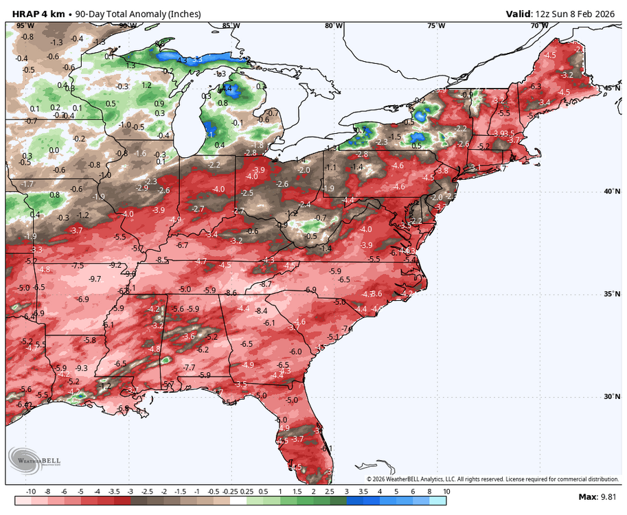
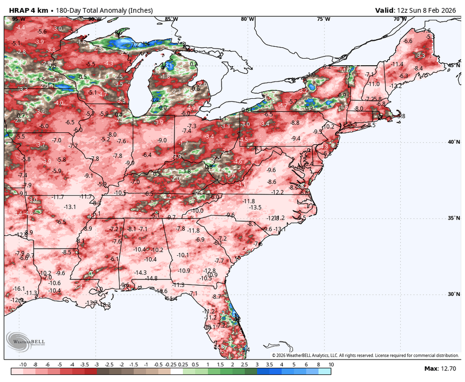
It’ll def be warmer this week overall and much more comfortable compared to what we’ve been dealing with, though the only “warm” day with respect to average looks to come tomorrow. If temps manage into the 40s that’ll make for daytime highs that aren’t much more than a few degrees above average. Western and actual central probably get there but a lot of guidance suggests the Sus Valley doesn’t even get out of the 30s. Tuesday night temps will stay up and probably have more of a + departure but we’re already bleeding cold air back in by that point behind what is now mostly a dry frontal passage. Rest of the week looks like a continuation of below average temps, although much closer to normal. Then we’ll see what this weekend system does. Snow prospects look to hinge on degree of secondary development to the Mid-Atlantic coast as we will likely have a more marginal cold airmass to work with. Overnight Euro was more of a cutter hence the brief mix to rain solution. GFS and Canadian further south with the primary and has the defined secondary low (esp Canadian solution). I’m thinking high probability this isn’t a clean system (strictly snow), but also good possibility of at least front end snows. Immediately beyond that potential system this weekend we look to more significantly moderate temp-wise for a time next week. WPO is forecast to head significantly negative again in the longer term, reloading Canadian cold. Continued +EPO/-PNA in the progs may mean that focuses out west at first, I think we’ll continue to be more vulnerable to cutting systems in that timeframe (next week). We should welcome precip in any form and any kind of a more active storm pattern, because we’ve been building a pretty sizeable negative departure the last 6 months in basically the entire East. If we get this weekends system, that would make 3 full weeks since the last significant precip maker. 90 day precip departures 180 day departures -
Central PA Winter 25/26 Discussion and Obs
MAG5035 replied to MAG5035's topic in Upstate New York/Pennsylvania
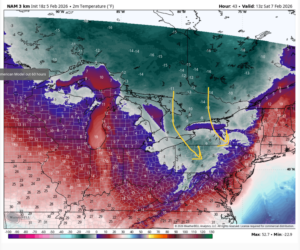
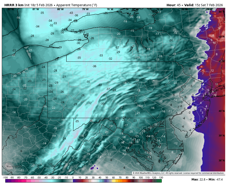
Geesh, I guess not. I’m probably in the minority here but I’m not really all that impressed with the wind threat if we’re talking strictly from a mph standpoint. Most guidance and that includes the high res stuff like the HRRR that normally ramps up surface winds barely support advisory winds much less anything of the variety that would cause widespread power outages. But I could get on board with a wind advisory for 45-50mph I suppose. Basically a typical wind event in other words, it gusts to 60mph at @canderson’s house in those anyways haha. This event also has a more northerly trajectory to the wind as well being more NW or even NNW.. less of a direct downslope component to enhance wind gusts IMO. What I am impressed with is the COMBO of the winds and cold temperatures. Dynamically this will be the coldest shot of the winter to date. The more northerly component to the wind minimizes modification of the airmass source travelling over the Lakes, which already have a good bit of ice with Erie >95% covered. Non-diurnal “High” temps for Saturday will occur before about 3-4am Sat morning. Sat daytime temps will struggle to get out of the single digits in most of the area. Laurels and some north-central might not crack zero. You can see how there’s an appendage of non-modified Arctic air that reaches PA. I drew the rough surface wind direction. It mostly goes over the frozen portion of Huron and Erie. Saturday morning will probably be the worst for wind chills, though it won’t be good all day. I think most of that extreme cold watch has a good chance of being upgraded to the full blown warning. Here’s the kind of wind chills the 18z HRRR put out after daybreak Saturday morning. I haven’t really seen those kind of wind chills since the Christmas 2022 cold shot. -
Central PA Winter 25/26 Discussion and Obs
MAG5035 replied to MAG5035's topic in Upstate New York/Pennsylvania
UNV got to 25ºF today, with similar temps around town up there. So it stayed at 7 days, which is still tied for the 2nd longest streak to that 1893 streak of 10 days. AOO broke their longest yesterday (that station only goes back to 1950) and added another day today only reaching 18ºF. That’s interesting that for the month as a whole, last January was actually colder. -
Central PA Winter 25/26 Discussion and Obs
MAG5035 replied to MAG5035's topic in Upstate New York/Pennsylvania
This winter has been tracking similarly to the last real consistently cold winters that we had back in 13/14 and 14/15, especially the latter. Main drivers then were heavily Pac influenced with a strong and persistently negative EPO and WPO much like we’ve had most of this winter so far other than when we warmed up for a couple weeks in early January. That alignment directs a continental source of cold air from Canada with no Pacific modification. The 13-15 winters achieved that without much help from any -NAO/AO, something we actually have had a good bit of this winter, and currently. The result has been a lot of cold in the east, and a historicially bad winter snow-wise in some parts of the west to date. So with that said, I’ll offer at least a little bit of hope. Starting to eye the following week after this week for some kind of period of modification after we probably get whacked with a couple days of arctic air comparable to what we just had next weekend. Looking at teleconnection forecasts right now, there’s a pretty sizeable shift progged to occur in the Pac realm occurring around the timeframe of that clipper and ensuing arctic shot. EPO and WPO both reverse to positive, and the monster +PNA we have reverses to negative. That combo will almost certainly inject Pacific modified air into the CONUS to some degree. How much negative NAO holds will probably have a hand in how that works into our part of the country. Nothing really reverses the -NAO/AO but some ensembles neutralize a bit more than others. So there could be some resistance here, especially with a solid snowpack in the Northeast. Resistance could in fact end up breeding more snow/mix events in our neck of the woods. But I’m currently thinking we’re looking at a milder pattern overall during that timeframe either way. And you can see the op runs of the GFS/Euro in the longer range sort of reflecting that shift. This week prior to the clipper won’t be all that bad temp-wise either, at least during the day. We will continue to have very cold nighttime lows with a deep snowpack and mostly fair weather (other than maybe Wed for some). -
Central PA Winter 25/26 Discussion and Obs
MAG5035 replied to MAG5035's topic in Upstate New York/Pennsylvania
System wise this coming week I don’t think we’re dead in the water yet for the Wednesday system, especially in the southern half of PA. NBM guidance has measurable from roughly the turnpike south and GFS generally in that ballpark. This certainly has time to trend back our way, though I think it would just be a lighter snowfall on the table. Solid agreement beyond that for a strong clipper tracking SE thru the lakes around the Fri-Sat timeframe. While staying plenty cold, low track north of PA might have the typical downsloping issues east of the mountains we’ve dealt with a lot this winter.. so we’ll see. As progged it’s a pretty strong system for a clipper, and it looks to usher in another reinforcing shot of arctic air. -
Central PA Winter 25/26 Discussion and Obs
MAG5035 replied to MAG5035's topic in Upstate New York/Pennsylvania
Friday morning was the only morning I ended up below zero here (-3 or -4ºF), I got to exactly 0.0ºF last night. Light influences from the developing coastal in the form of light wind and cloudcover as you mentioned likely kept things from fully decoupling. Still been a heck of a cold stretch, when the temps likely fail to reach 20ºF again here today that will break the longest streak of days under 20ºF for KAOO that goes back to 1948 for that station. That was 7 consecutive days set in Feb 1979, and today will make the 8th day. The lows in western PA the last few nights have been wild where there has been ideal radiational cooling conditions. For official ASOS stations, the coldest I saw for last night was -20ºF north of Pittsburgh at Zelionople Municipal Airport (KPJC). -
Central PA Winter 25/26 Discussion and Obs
MAG5035 replied to MAG5035's topic in Upstate New York/Pennsylvania
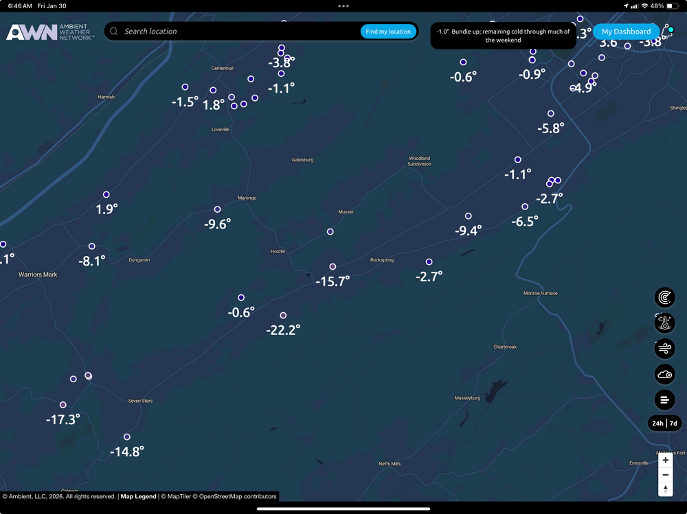
Been bouncing between -2 and -3ºF this morning here. Temperatures especially in the west and central this morning have ended up pretty close to the modeled temps of the coldest models (Euro/GFS). On the Mesowest network there’s several stations reporting -20 or colder, with a -28 near Slippery Rock. On the Ambient network there’s a -22ºF in the Barrens region SW of State College, a typical optimal radiational cooling spot. Temperatures tonight will likely be even colder overall with more widespread below zero lows. -
Central PA Winter 25/26 Discussion and Obs
MAG5035 replied to MAG5035's topic in Upstate New York/Pennsylvania
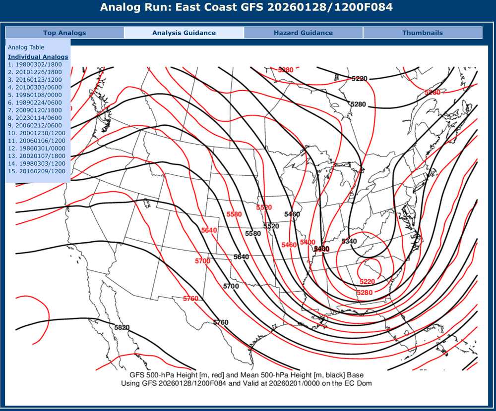
I just think the phase happens too late, its hard to bring a later developing coastal low off the Carolina coast back in close enough to affect central PA without some kind of a situation where its completely cut off/blocked downstream.. which doesn’t look to be the situation here. The storm deepens rapidly and may retro a bit but then it shoots NE. New Euros doing some kind of dumbbelling type action with the low, which acts to really drive up its snow solution in southern New England. Cold’s probably playing a hand in it too, we’re in a frigid pattern. We’re looking at the potential for some record lows Saturday morning as this storm is just beginning to take shape. The center of the closed 500mb low is all way down over Savannah, GA as the trough rotates negative. That’s a bit too far down for us, the surface low explodes on the Gulf Stream and will likely run up along it. -
Central PA Winter 25/26 Discussion and Obs
MAG5035 replied to MAG5035's topic in Upstate New York/Pennsylvania
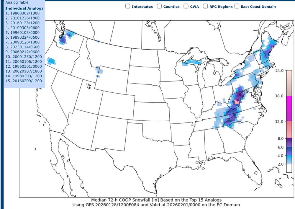
The only thing really keeping me into this threat to any degree is the 500mb ridge axis in great positioning for C-PA. Otherwise it just looks like the trough is going to swing negative too late and system stays relatively progressive. Looked a little bit further into the CIPS analog stuff and off GFS guidance one of the top analogs for the Northeast/East Coast domain that come up is the Boxing Day 2010 storm, which I think is most the representative analog vs forecast setup of a top 5 that consisted of Jan 2016 and even Jan 1996. That’s why the 90th percentile is off the hook on that analysis. Statistically, those accumulations represent amounts that are higher than 90%+ of the dataset.. the highest outliers in other words. Having those big hitters in the mix also skews the mean as well. Here’s the median snowfall, which indicates a lot of these analogs didn’t produce much of anything. Here’s the mean 500mb vs GFS The mean western ridge axis on the analogs is actually a tad east of what the GFS has, and it’s definitely west of the alignment for the Boxing Day 2010 storm. That storm actually tracked up from the Carolina coast and inside of the benchmark while the general consensus of guidance right now is to take the surface low up from Hatteras outside (southeast) of the benchmark. So I think this certainly has room to trend snowfall back our direction, but I’m fairly doubtful it’ll be enough for C-PA due to the reasons mentioned at the top of the post. The storm gets going too late. -
Central PA Winter 25/26 Discussion and Obs
MAG5035 replied to MAG5035's topic in Upstate New York/Pennsylvania
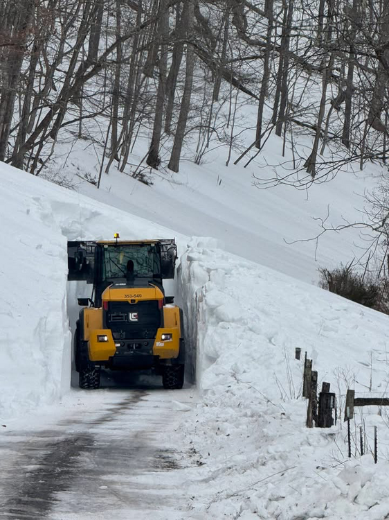
At least we didn’t see this kind of crazy sleet. https://www.wboy.com/pendleton/watch-crews-use-excavators-to-clear-sleet-slides-in-west-virginia-mountains/ Pendleton County, WV -
Central PA Winter 25/26 Discussion and Obs
MAG5035 replied to MAG5035's topic in Upstate New York/Pennsylvania
Looks like focus could be starting again on about this time next weekend once everyone rests up haha. The 0z Euro op blasted central and eastern PA tonight. This amplifcation and major, highly anomalous closed 500mb low is notable on all the major ops, but the Euro’s the only one that had this kind of storm solution tonight. 500mb ridge axis out west is lining up in the spot favorable for a coastal to strike C-PA if we can time a phase. So we’ll see what happens with this, plenty of time to reel it in. -
Central PA Winter 25/26 Discussion and Obs
MAG5035 replied to MAG5035's topic in Upstate New York/Pennsylvania
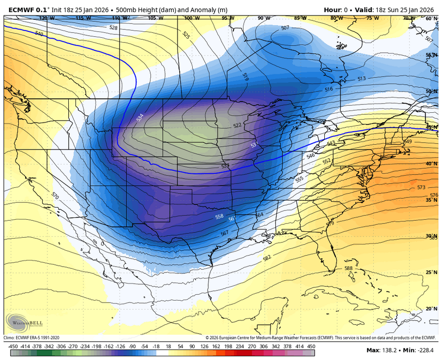
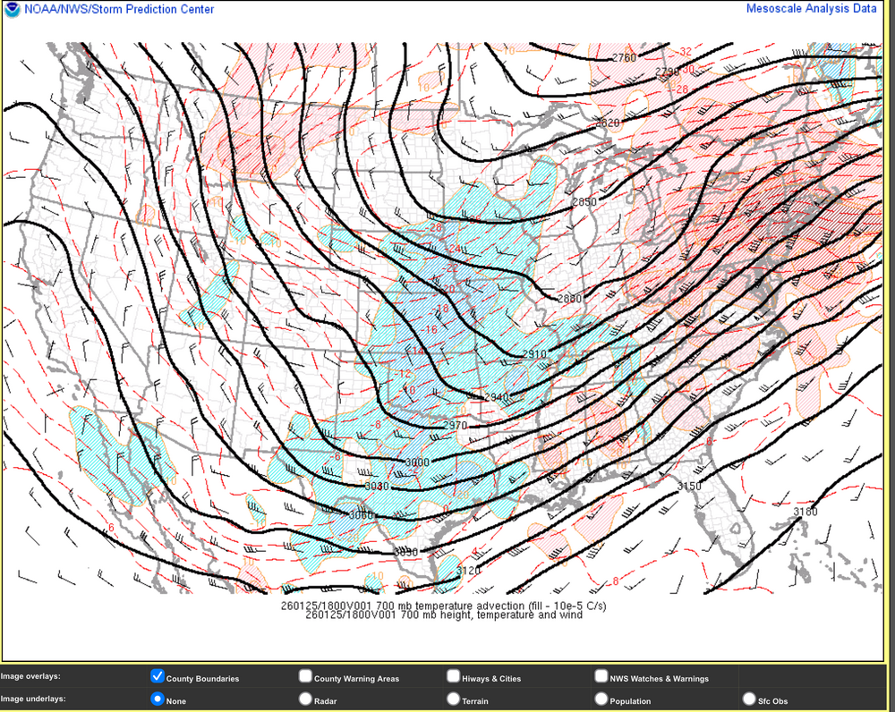
Considering we had the kind of mid-level pattern that we did for this storm, I’d say we did extremely well. Here’s 500mb heights and anomalies during the height of the storm today at the 18z initialization of the Euro. And Mesowest 700mb heights and temp advection at 18z today. This drove the mix line and the NAM ended up handling that the best. No closed 700mb low and the 700mb trough was aligned way west. Weaker secondary surface development to the coast wasn’t going to affect this issue. The fact that we had a forum wide warning event with widespread double digits while also being about as cold as you get at the surface for a synoptic event out of the Gulf is pretty remarkable with an alignment like that. At the end of the day this storm was mostly a moisture charged overrunning event with a very strong arctic air mass in place. -
Central PA Winter 25/26 Discussion and Obs
MAG5035 replied to MAG5035's topic in Upstate New York/Pennsylvania
I think you’ll see some of it up that way, perhaps an inch or so if the stuff in western PA holds together good. Less sure once south of about Harrisburg, might not see much additional down there. This kind of skirts ENE, and then westerly flow kicks in eventually and that will relegate what’s left to western PA and the Laurels most likely. -
Central PA Winter 25/26 Discussion and Obs
MAG5035 replied to MAG5035's topic in Upstate New York/Pennsylvania
Got out and did some measurements with the lull in the action, I’m at 11.6” right now. The comma head stuff is on the doorstep so we’ll see how much additional I can muster. Temp is still only 10ºF. This snow is very powdery but it is also dense, which is typical of Gulf storms. Never mixed but I do think the ratios suffered a bit due to the warm nose. Being so high up that would have affected growth in the 700mb layer which was likely where the best lift was. Given the heavy rates basically all day today this could have easily been more. I did see a couple 13 and 14” totals reported elsewhere in Blair. -
Central PA Winter 25/26 Discussion and Obs
MAG5035 replied to MAG5035's topic in Upstate New York/Pennsylvania
Exactly one week ago, haha. -
Central PA Winter 25/26 Discussion and Obs
MAG5035 replied to MAG5035's topic in Upstate New York/Pennsylvania
-
Central PA Winter 25/26 Discussion and Obs
MAG5035 replied to MAG5035's topic in Upstate New York/Pennsylvania
Back in western PA the mix line is remaining well south of Pittsburgh, generally near the Mason-Dixon line. That then cuts up NE thru Bedford/Fulton to where it’s pressed up into the Sus Valley. The next couple hours are going to be where the max WAA occurs to drive the sleet up into the Sus Valley. I would expect a changeover back to snow to try to work back down thru the LSV eventually as that intense WAA passes and the column starts cooling at that level. However, the big thing by that point is going to be the race between that and the main precip shutting off. Models seem to be timing a mid-evening shutoff (10pm ish). There’s a lot of storm to go. -
Central PA Winter 25/26 Discussion and Obs
MAG5035 replied to MAG5035's topic in Upstate New York/Pennsylvania
Thats certainly possible, That 700-800mb area is the only part of the column that warms to the point of mixing and that’s quite high up. We never lose 850mb on down, and there’s plenty of lift at that level as well. -
Central PA Winter 25/26 Discussion and Obs
MAG5035 replied to MAG5035's topic in Upstate New York/Pennsylvania
Heaviest snow of the event so far, working on 7”. Temp 9ºF -
Central PA Winter 25/26 Discussion and Obs
MAG5035 replied to MAG5035's topic in Upstate New York/Pennsylvania
Past the 4” mark here with moderate to heavy rates. Temp 8ºF -
Central PA Winter 25/26 Discussion and Obs
MAG5035 replied to MAG5035's topic in Upstate New York/Pennsylvania
The first heavier band has arrived and it is ripping here..probably working on an inch or so already. Decent flake size and it’s fluff. Temp is down to 9ºF, which is nuts for an event like this. -
Central PA Winter 25/26 Discussion and Obs
MAG5035 replied to MAG5035's topic in Upstate New York/Pennsylvania


