MAG5035
-
Posts
6,078 -
Joined
-
Last visited
Content Type
Profiles
Blogs
Forums
American Weather
Media Demo
Store
Gallery
Everything posted by MAG5035
-
Central PA Spring 2026 Discussion/Obs Thread
MAG5035 replied to Voyager's topic in Upstate New York/Pennsylvania
I busted out of the clouds here, was as high as 63ºF earlier. Still around 61ºF -
Central PA Spring 2026 Discussion/Obs Thread
MAG5035 replied to Voyager's topic in Upstate New York/Pennsylvania
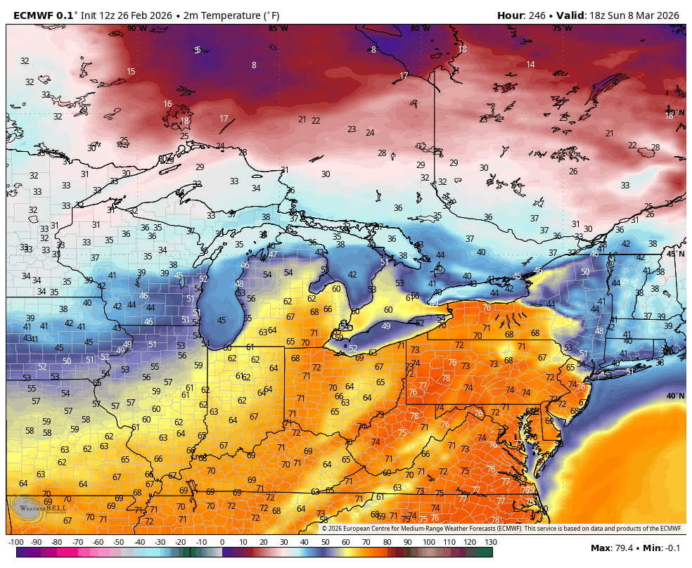
0.65” of rain here yesterday. Eastern PA definitely looks to be denied a full torch this weekend as cool air damming, cloud cover and maritime flow off the Atlantic have a firm hold east of the mountains. Meanwhile from the Laurels westward, increasing breezy southwest flow is going to make for much warmer temps, likely making a run at 65-70 or so on Saturday. Sus Valley may eventually mix down 50s to near 60 later Saturday/Sat night as a weak frontal passage approaches. Mon-Wed is the real time frame where it looks quite warm, as it has looked consistently on models for like the last week. Tuesday is the best chance for at least the southern half of PA to make a run at 70ºF ahead of the next system. Some difference between Euro and GFS with the Euro being much more expansive in PA with the very warm temps and GFS more confined to southern PA. Much more uncertainty abound beyond that, big differences between the Euro and GFS. Euro has been way colder around the St Patty’s day timeframe and also has a storm on tonight’s 0z run. GFS bottles up cold air more in Canada and runs a further north storm track. Both models and ensembles develop the really negative WPO, which should put a lot more cold back in Canada. They’re also pretty firm on a pretty positive AO and NAO though, which would suggest cold intrusions into the US are limited and brief. Difference area is the PNA, where the Euro/ensembles (and Canadian) reverses a pretty negative PNA to positive to set up western ridging and a chance at the kind of storm it puts out at 0z tonight and holding a cold pattern more. The GFS op just keeps the PNA solidly negative and its ensembles do reflect the other models more with the reversal but is more neutral. I’m fairly pessimistic overall on any decent snow chances in that timeframe mainly due to the +NAO/AO, but building a western ridge even briefly would at least allow for a window to try to line something up. -
Central PA Spring 2026 Discussion/Obs Thread
MAG5035 replied to Voyager's topic in Upstate New York/Pennsylvania
Freezing rain has arrived here and quickly glazing. 29/27ºF -
Central PA Winter 25/26 Discussion and Obs
MAG5035 replied to MAG5035's topic in Upstate New York/Pennsylvania
BGM’s take, since they have been updating CTP’s AFD since yesterday morning. -
Central PA Winter 25/26 Discussion and Obs
MAG5035 replied to MAG5035's topic in Upstate New York/Pennsylvania
This one’s for you @Voyagerhaha. Once we route out the lingering cold later next week after whatever happens Monday, guidance shifts high pressure to a Bermuda high positioning and that would likely usher in the warmest air we’ve seen since about October. Euro/GFS both have multiple days in the 70s late next week into next weekend. Given setup and teleconnections (+AO/NAO, +EPO, -PNA) I don’t think this one get’s muted.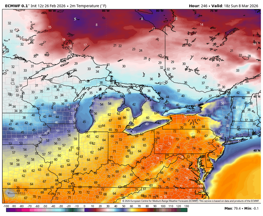
-
Central PA Winter 25/26 Discussion and Obs
MAG5035 replied to MAG5035's topic in Upstate New York/Pennsylvania
The NBM looks quite good with it as well at the moment. Hopefully we don’t lose it like the system that originally looked like it was going to impact tomorrow or this thing edges north more and we end up with a messier outcome I do believe this potential event might be the last good shot at something decent for awhile as the signals for a more persistent and significant warm up in the East beginning later next week are looking pretty strong.
-
Central PA Winter 25/26 Discussion and Obs
MAG5035 replied to MAG5035's topic in Upstate New York/Pennsylvania
Probably the Horseshoe Curve, which would make sense given such high seasonal totals and also being that timeframe was Altoona’s Pennsylvania RR heyday where a lot of that kind of reporting was likely done along the mainline. That’s close to halfway up the Allegheny Front (leading ridge of the Laurels) between the city itself and the top at Gallitzin/Cresson. It’s hard to find much reliable data for the city itself. KAOO is more than 15 miles and one ridgeline over SE of the city. The airport doesn’t get as much snow, esp in upslope/LES and clipper situations being just that much further away from the Laurels with downsloping. Then of course, the really high variance from the city to the top of the Laurels in just a 5-10 mile drive. I consider roughly 40-50” an average season here, using the much more reliable snow data up in State College as a general baseline (45.9 since 1893 and 43.8 on the 1991-2020 avg). It’s not perfect but I am averaging 35.7” since the 17-18 winter with some pretty lousy winters the last 4 years. On the other hand, what will be the new 30 year avg (2001-2030) is currently running around 38” a season for State College right now barring some big winters the next 4 years. -
Central PA Winter 25/26 Discussion and Obs
MAG5035 replied to MAG5035's topic in Upstate New York/Pennsylvania
I had a light coating first thing this morning but that is long gone as well as some of other snow that is on the ground. Despite getting the first double digit storm in 5 years and the prolonged cold and pack, I’d probably rate my winter a C if not much else happened next month. The only other snowfall that even got to the 3” mark this winter here was all the way back on Dec 2nd. -
Central PA Winter 25/26 Discussion and Obs
MAG5035 replied to MAG5035's topic in Upstate New York/Pennsylvania
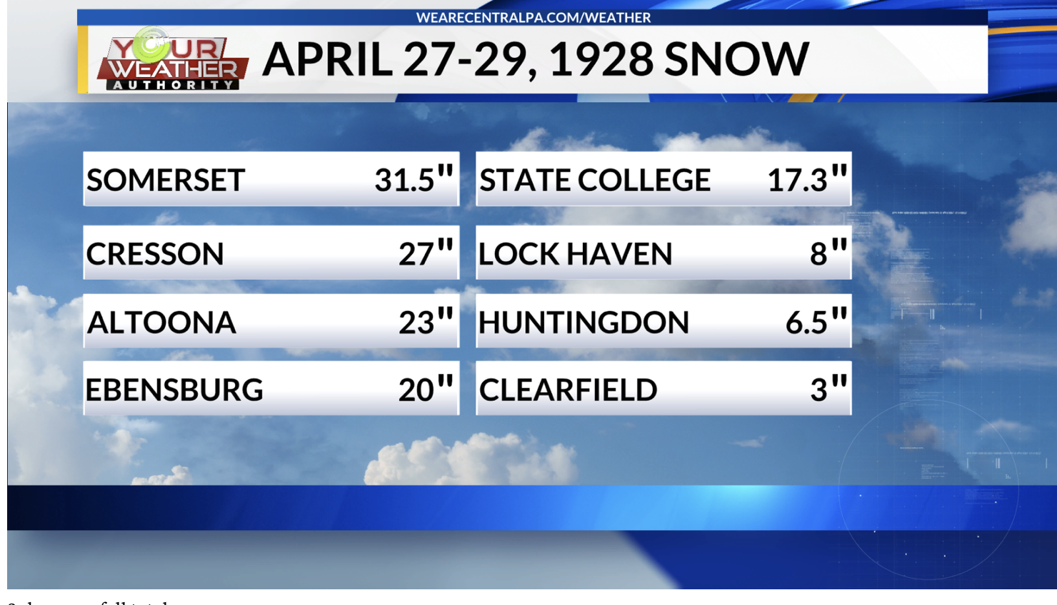
I’ve mentioned it somewhere in one of these threads in the past. I don’t believe that event dumped anywhere near that much snow in Harrisburg though. The NOAA NOWdata at Harrisburg/Middletown for those two days has over 3” of precip but only 2.4” of snow. It did dump those kinds of amounts back this way and on down the Apps thru WV and KY though. The local station here had something on it a few years ago. https://www.wtaj.com/weather/the-late-april-snowstorm-of-1928/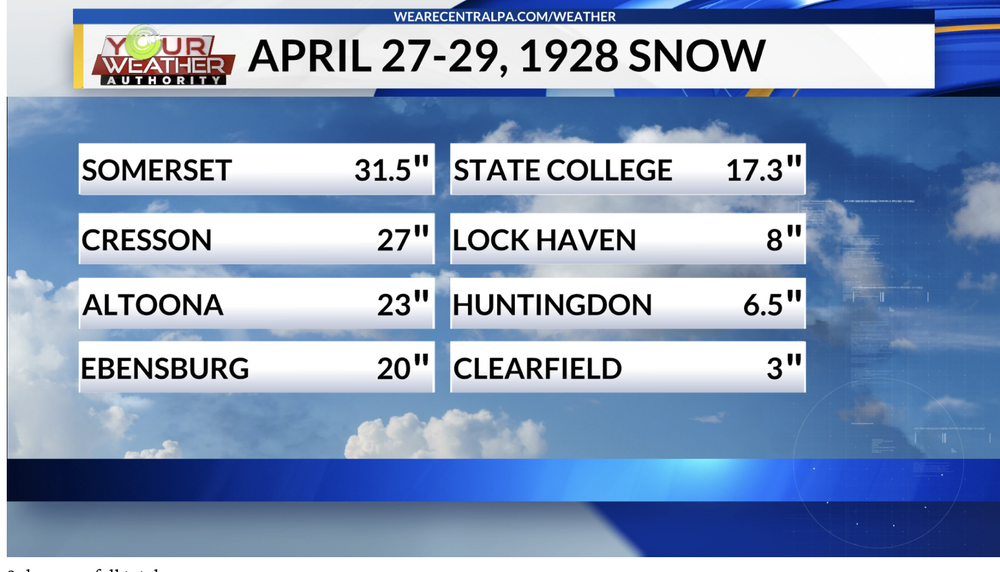
-
Central PA Winter 25/26 Discussion and Obs
MAG5035 replied to MAG5035's topic in Upstate New York/Pennsylvania
That makes me wonder about the statistical anomaly of the stretch of winters from 92-96 (sans 94/95), which in additional to being 3 of State College’s top 5 snowiest winters (93/94 #1 with 109.3”) was the heyday of really big snowstorms back this way. 12/10/92, 93 Superstorm, and the 3/3/94 nor’easter were three events in basically two winters that delivered that kind of snow in this part of central PA. -
Central PA Winter 25/26 Discussion and Obs
MAG5035 replied to MAG5035's topic in Upstate New York/Pennsylvania
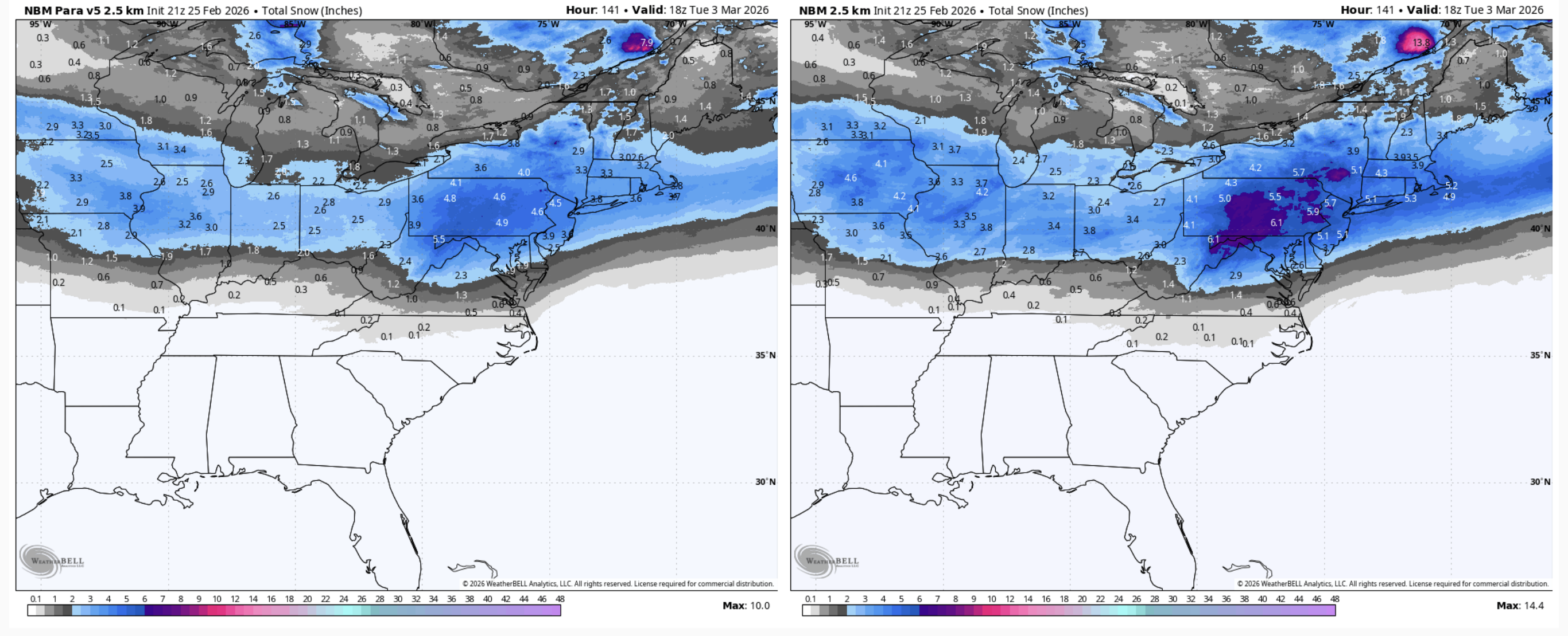
2.9” was what ended up calling the snow total here, about 1.3” from approx midnight to 8am Sunday morning and then another 1.6” from mid Sunday evening thru mid morning today. Some upslope stuff trying to set up so maybe can sneak a little bit more. This brings my season total to a fairly meh 28.7”, generally on par with the last 4 winters if winter ended today. Plenty of time obviously but it’s starting to get late. Clipper tomorrow night will likely favor NW PA, Laurels and perhaps down I-80 over to the Poconos. Track of the low staying in the lakes doesn’t bode well for much making it into the Sus Valley (downsloping). Then we’ll see what we have to work with for Thursday’s wave. Today’s suite has GFS/Euro ops skirting most precip south, Canadian half decent, and NAM/RRFS more mix/rain confining snows to northern PA. GFS/Euro ensembles look a little more amped on average vs their ops. I think most of us should see precip from this wave, my main concern is p-type issues. -
Central PA Winter 25/26 Discussion and Obs
MAG5035 replied to MAG5035's topic in Upstate New York/Pennsylvania
Somebody in SE Mass is gonna end up with over 3 feet with that band sitting over them right now. Most reports around there are already nearly 2 feet. -
Central PA Winter 25/26 Discussion and Obs
MAG5035 replied to MAG5035's topic in Upstate New York/Pennsylvania
I could be wrong but it sounds like everyone at work just wanted the extra day off, sound reasoning be darned. Which would make that really unfair for you to take that kind of flak. You certainly made a better forecast call than I did there. The other part of your post is a really good example of why I personally don’t do the YouTube/F-Book/Twitter Met stuff. I’d much rather discuss in a place like this forum where enough of the regulars (certainly not all haha) for the most part understand the difficulty in nailing this stuff down. Don’t ever be discouraged making your forecast calls in here. -
Central PA Winter 25/26 Discussion and Obs
MAG5035 replied to MAG5035's topic in Upstate New York/Pennsylvania
Speaking of egos, I wonder how DT’s doing today haha. I mean yea DC wasn’t the epicenter, but let’s not forget where the Euro was with the coastal aspect of this thing as recently as like Friday. -
Central PA Winter 25/26 Discussion and Obs
MAG5035 replied to MAG5035's topic in Upstate New York/Pennsylvania
There was also a corridor of heavier snow reports along the Franklin/Adams border that translated to that same band that’s produced a couple 6”+ reports east of State College and continued down thru northern MD. That 12.3” is a Cocorahs report. -
Central PA Winter 25/26 Discussion and Obs
MAG5035 replied to MAG5035's topic in Upstate New York/Pennsylvania
29ºF and snowing decently at the moment with the band that just dropped in from the north. This stuff looks like it has some enhancement from Ontario with the due northerly fetch so maybe it’ll actually do something this morning. For now 1.2” fell overnight to bring storm total to 2.5”. Been pretty breezy with a high gust overnight of 35.6 mph on the station. Gonna have a look at totals vs the map I put out when this thing completely wraps up. Did not expect the York/Lancaster realm to do as bad as it did. I knew it was boom or bust potential there but I expected at least warning criteria to be met there fairly easily. The temps were an absolute killer yesterday with the lighter precip phase of the storm. IVT set up further east as noted and I think the storm really exploded just a hair late. It is living up to its billing in NJ/NYC/LI and beyond. There’s already scattered 20”+ reports in NJ and LI, as well as a 71mph gust on the tip of LI. Official obs in Central Park, La Guardia, and JFK all reported 15” or so around 7am with a good bit of snow to go. -
Central PA Winter 25/26 Discussion and Obs
MAG5035 replied to MAG5035's topic in Upstate New York/Pennsylvania
It’s been a much more powdery snow with this 2nd wave that made it back here a few hours ago. The streets and stuff have caved with temps now back to 28ºF but the rates just aren’t doing it here. I only have about 0.7” new in all that time. Combined with the initial snow that came through overnight last night into first thing Sun morning that brings me right around 2” total for the storm so far. -
Central PA Winter 25/26 Discussion and Obs
MAG5035 replied to MAG5035's topic in Upstate New York/Pennsylvania
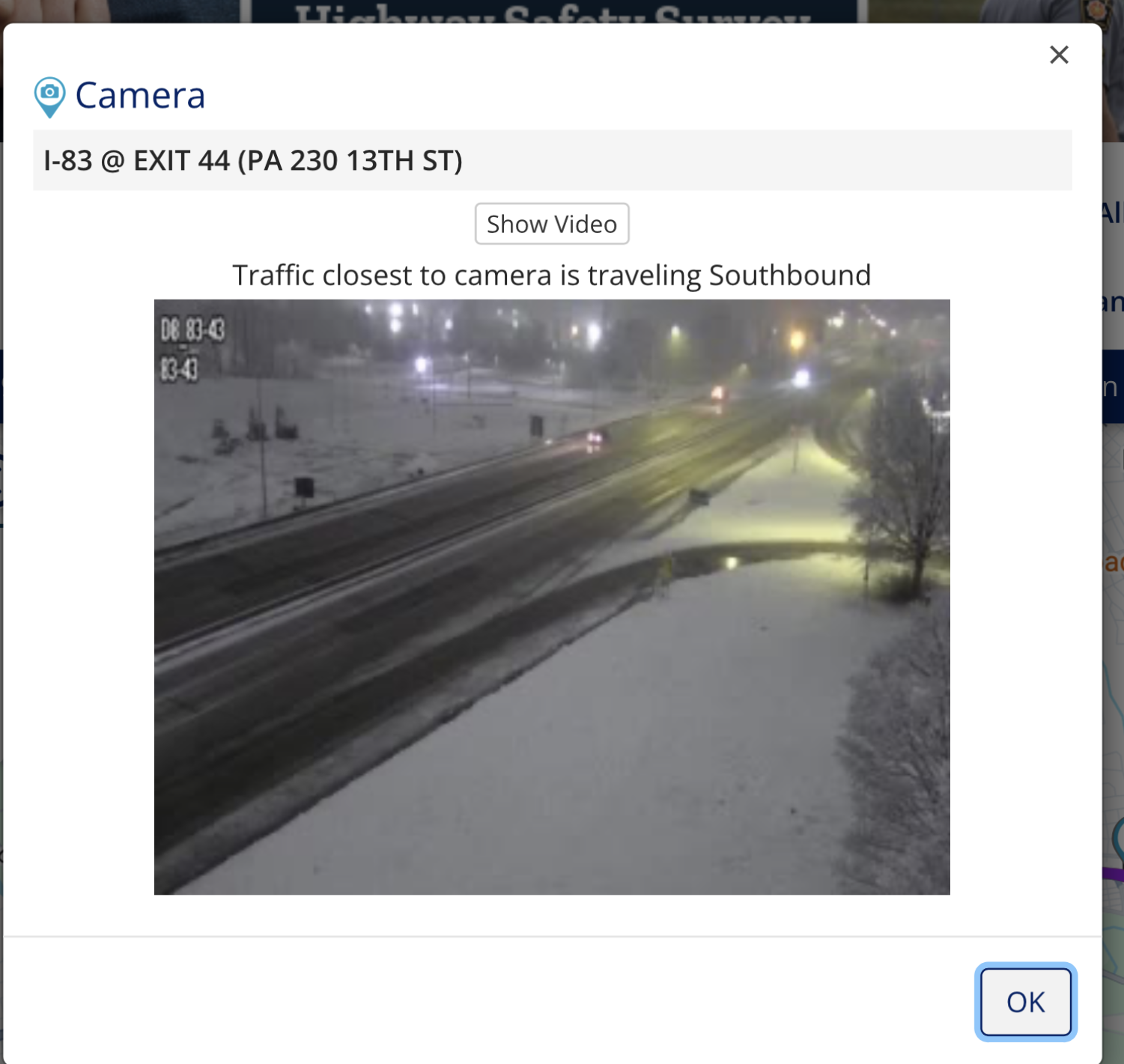
This is one of those situations I wish there was a radar located somewhere in the middle of the Sus Valley to see the banding better, as there are clearly some haves and have nots when it comes to where there are more significant accumulating snow areas. 511 cameras in and around the Harrisburg area look half decent though, showing some of the primary roads caving.
-
Central PA Winter 25/26 Discussion and Obs
MAG5035 replied to MAG5035's topic in Upstate New York/Pennsylvania
Nice placement of the comma head on central/eastern PA. So far the coastal low is still pretty close to the Delmarva coastline and hasn’t started to fade east yet. -
Central PA Winter 25/26 Discussion and Obs
MAG5035 replied to MAG5035's topic in Upstate New York/Pennsylvania
Accumulating snow has finally resumed here for the first time in the last like 10-12 hours as that renewed surge of steady precip backing west has reached the I-99 corridor. Winds are up too, with a high gust of 26mph (NNW). Temp down to 30ºF -
Central PA Winter 25/26 Discussion and Obs
MAG5035 replied to MAG5035's topic in Upstate New York/Pennsylvania
Surface obs and radar line up pretty good showing the convergence zone for that inverted trough band. It has finally begun to snow again here, lightly. Temps are back below freezing as well back to 31ºF. At this point I’d consider another 1-2” from this event a win with that band setting up to the east of here. -
Central PA Winter 25/26 Discussion and Obs
MAG5035 replied to MAG5035's topic in Upstate New York/Pennsylvania
I-81 from Shippensburg on south is starting to look snowy on the 511 cams. Additionally US 322 goes from snow on the ground on the Lewistown side of the narrows to bare ground on the Mifflintown side. -
Central PA Winter 25/26 Discussion and Obs
MAG5035 replied to MAG5035's topic in Upstate New York/Pennsylvania
Boxing Day 2010 didn’t have the inverted trough and had more of an actual sharp precip gradient from nothing to a bunch. This system has plenty of precip thrown back into central PA right now. Temps are the issue, I said a couple times the last few days temps and rates were going to be a key thing for I-81 corridor and NW. Unfortunately I didn’t expect surface temps to be warm enough to actually cause a lot of this stuff to be rain in the Sus Valley lower elevations today.. I was more worried about rates. That puts more reliance to make it up on the direct banding from the coastal as it winds up and eventually turns things over as we get towards this evening. The big change there is the formerly aggressive guidance bringing the low in up close is now quickly jumping it ENE over or perhaps just SE of the benchmark. Which actually would be another difference from Boxing Day haha. That tracked straight up well inside the Benchmark to the edge of Cape Cod. The low kicking east faster is going to reduce the time the Sus Valley (esp York/Lancaster) can get any stronger bands from the coastal. -
Central PA Winter 25/26 Discussion and Obs
MAG5035 replied to MAG5035's topic in Upstate New York/Pennsylvania
Current obs.
-
Central PA Winter 25/26 Discussion and Obs
MAG5035 replied to MAG5035's topic in Upstate New York/Pennsylvania
I think your in a good spot to be a winner for that inverted trough band.