MAG5035
-
Posts
6,078 -
Joined
-
Last visited
Content Type
Profiles
Blogs
Forums
American Weather
Media Demo
Store
Gallery
Everything posted by MAG5035
-
Canadian’s coming in looking way better as well. Good start to the 0z suite. Been waiting to see how things respond as sometimes these storms kind of go away in the models during this particular range. The ingredients are going to be there for a big storm if we can amp and phase it in time to turn it up the coast.
-
In the middle of quite the snow band right now. Haven’t been out to measure yet but looks like around an inch.
-
We did actually end up with a fresh half inch of snow early this morning, which brought the running total up to a crippling 1.1” haha. 30/27ºF currently awaiting the messy part of this overall event to arrive later.
-
Only 0.6” here today, a decided underachiever even being positioned on the fringe of this event. Still need 11” of snow just to reach last year’s lackluster season total. One of these bigger events needs to get us at some point.
-
I’m up at Blue Knob currently, the snow started a bit after noon up here. Looks like about an inch so far. Judging off the cameras looked like some kind of coating to perhaps a half inch at the house.
-
Boy things have sure escalated the last few runs in terms of the medium-longer range. It appears we transition into a pattern next week more favorable for traditional amplification and the overnight runs have definitely obliged on that front with the big storm being progged D8-10 on both Euro and GFS as well as some ensemble support. That’s when the MJO is forecast to be running in 8 by that point, coupled with the PNA forecast to transition to postive and the NAO transitioning from deep negative toward neutral. Definitely a period of interest for sure. Working backwards, the weekend system is trending towards somewhat more interesting. Models seem to be starting to respond toward the fact there is a pretty significantly negative NAO block ongoing and have thus started forcing that deeper low more SE towards the coast instead of a straight lakes cutter. GFS/Euro have actually been taking the low to the coast along or under the M/D line, with the GFS being the colder scenario. Either way, that storm might not be the straight forward brief mix to rain scenario it had been looking like. Lastly, we still seem set for today.. least in terms of what I was thinking for accums. No real changes on those thoughts.. which was basically not much above I-80, 1-2” between I-80 and the turnpike, and 2-4” turnpike south..with near the M/D line maybe seeing a couple 5” amounts. One thing I’ve been watching is some guidance has been getting the snow up into the central counties a bit further in latitude.. so AOO-UNV corridor could possibly get into a lower advisory amount type scenario. We shall see. Tomorrow’s mix scenario that may start as more snow is still there but QPF has been kind of lacking with that lately. It will likely need another advisory for most in here for at least T ice expected and maybe an inch or two of snow for some.
-
I haven’t really posted much lately on the next two events but the evolution of this becoming almost essentially a single two pronged event of sorts between Tuesday and then the system that tries to cut later Wednesday is a detriment to the Tuesday one being the widespread bigger C-PA snow event it otherwise could be… as the system that makes Tuesday’s event ejects out weaker and the energy left for Wed-Thurs one digs. There’s still plenty of moisture for Tuesday, just on a fast W-E flow. So while I can’t rule out a bump north in the next 24hrs, I’m not really expecting more significant accums to get above about the turnpike or so. IMO, this is looking like a 1-2” between the turnpike and 80 and advisory (2-4” perhaps some 5 on the M/D) in the southern tier of counties centered on the turnpike. Better snows south and not much once above 80. That leaves the Wed-Thur system quick on this one’s heels that is going to try to cut into a fairly well positioned Canadian high. Given the reinforcing high and also how quick on the heels this is of something that presumably would have just dropped a good swath of snows centered on the DC/NOVA folks, this has a good chance of running a wave of front end snows much further up into eastern and central PA before any mixing. Especially if the precip gets its act together more quickly.. like the RGEM and GFS has for example. There may not really be much of a lull between these systems in the end.
-
Here’s what the roads looked like a bit ago, that’s entirely sleet. Things are getting plowed off now but there’s been more freezing rain in the mix. Still about 30.
-
Measured roughly 1.3” of pure pingers so far. The pellets are really fine so it makes walking on it like walking on the beach.
-
It’s been sleeting so hard we’re already getting close to as much as we had on the ground Wed Night for the whole event, which was about an inch.
-
-
Thunder sleet, again.
-
The first small wave of precip has arrived here as a pretty decent burst of sleet, already whitening things. 28/25ºF
-
I had about an inch of sleet and some minor freezing rain accumulation this morning to go with what ended up being 4 lightning strikes I saw between 4-5am this morning. I dunno if I’ve had that much thunder and lightning during the whole late summer and fall lol. Mixed out here around 2 or so and went from 34 to 48 in about 35 minutes, so a pretty good meltdown ensuing and quite windy.
-
28ºF and mostly heavy sleet now, with a bit of freezing rain in the mix as well. I’ve seen three lightning strikes.
-
Officially thunder pingers here with that line coming overhead. Nice lightning strike.
-
28ºF/23ºF and a steady freezing drizzle has commenced here in the last 20 minutes. Already icing over everything.
-
The thing with this pattern coming up in this timeframe is it’s likely that kind of a monster swath of snow is going to materialize in some form in the aggregate sense. Perhaps not as wide, but there’s going to be a swath of big winners from this pattern. Overall as I mentioned a couple days I think it’ll be an upstate NY and New England being the biggest beneficiaries, as they’re also going to total decent snows from tonight and Saturday’s event. That doesn’t mean we can’t score a decent snow event or two. The big driver in northern PA’s big totals on the 12z Euro (about 30” of it) mostly came from the modeled long duration event that was way out in like D12 or so. To answer your question, the last time northern PA had a swath like that was the December 2020 storm. That had a band of 2-3+ feet of snow up there, including Emporium over to Renovo and on northeast. I do believe it was also the original wsptwx’s biggest ever snowstorm as well. I think our best opportunity to score a decent area wide snow event that has limited or no mixing is going to come from the thing that’s progged near mid week next week. And there’s a lot to resolve with that, but that seems like the timeframe that lines up with the boundary perhaps being low enough. Beyond I don’t quite think the pattern is going to go really cold yet and we’re going to continue to ride the line. We’re in phase 6 of the MJO right now and models are varying with the speed at which that moves into 7 and eventually the colder phases. We also have some mixed teleconnection signals coming up while we otherwise maintain -NAO/AO and have AK ridging. We’re lucky we’re in the game given the phase 6 MJO, that’s traditionally the torchiest of the torchy phases in JFM. I do still think the eventual end game this month is it will get quite cold with respect to average, but that may be more during the second half of the month.
-
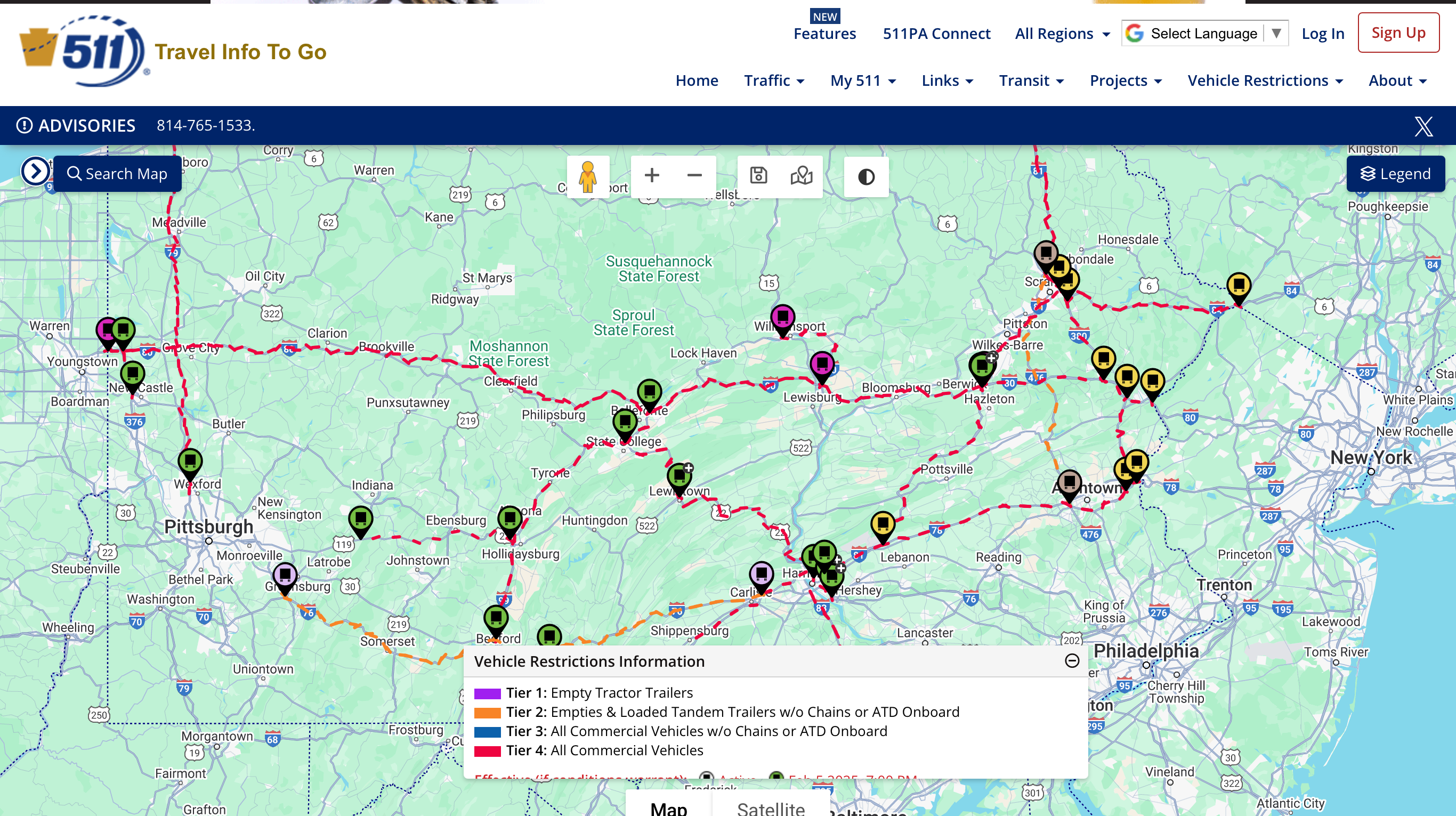
PennDOT not messing around when it comes to scheduled tier restrictions tomorrow night. Most major routes are tier 4, basically restricting everything except passenger cars/trucks and emergency vehicles.
-
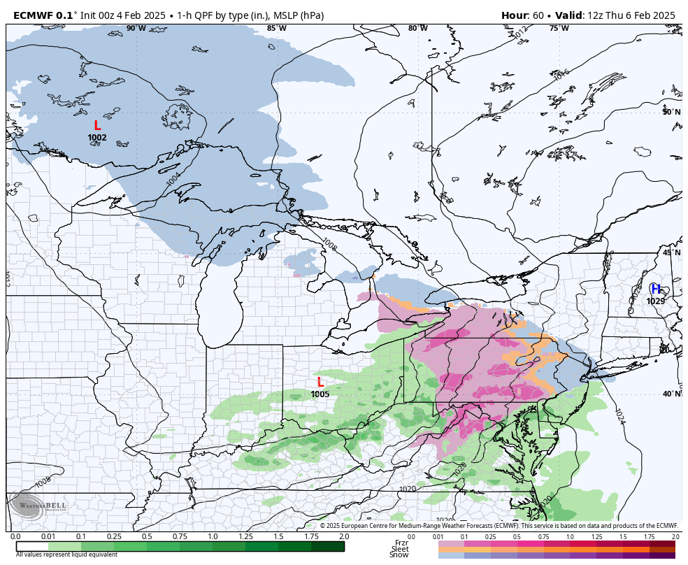
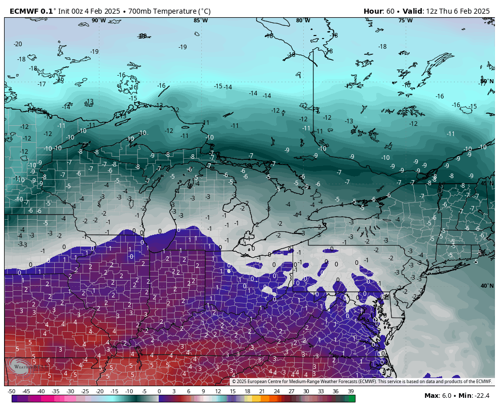
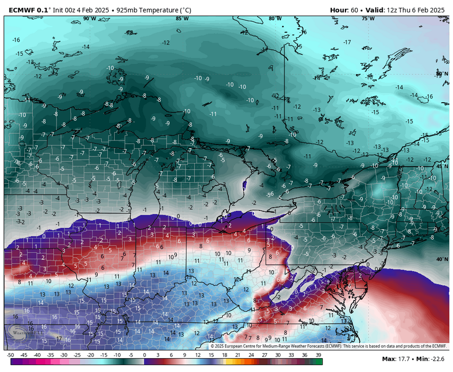
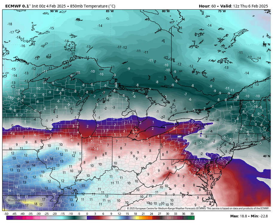
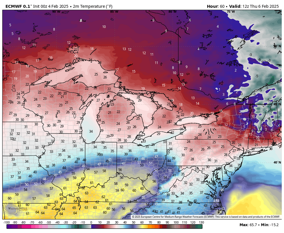
0z Euro continues to have a really large swath of mostly freezing rain with Wed/Thur’s event. Looking at thermals not really sure why it’s like that. Sleet may end up being the dominant p-type for many. Using hour 60 at the 1 hr level here’s a breakdown up to 700mb at what it has at that point. 1 hr QPF/p-type 2m temps 925mb (3000 ft temps) 850mb (5000ft) temps 700mb (10k feet) temps As you can see, well below zero ºC temps are well entrenched at 925mb level and the 850 temps are even solidly below zero in most of eastern PA. The warm intrusion goes quite high with this event, with the 700mb level near 0ºC. This really implies a solid period of pingers for most of us IMO. But the WAA intrusion will be top down as the event progresses, things will eventually change to freezing rain and then rain as the event ends. I think CTP’s watch placement is good for now, with perhaps them maybe adding a tier or two of counties east. What might happen with the Sus Valley is the business end of the heavier precip is sleet and a much shorter period of freezing rain before temps edge above freezing. Wild card is what happens earlier in the day on Wednesday with the ribbon of WAA forced snows that some models are showing with varying results. The Euro didn’t have it at all. I suspect we’ll have something with that though maybe not as robust with the NAM. Taking these threats one at a time. The weekend ice threat still looks similar to this one, though this one might end up with more actual QPF. For an actual snow event in C-PA I’m really liking what models have been showing around the 12th. I think we’ll be much better positioned for that period.


-
Daytime high was 53ºF here before falling back to the 40s early this eve. However, gusty winds ahead of the frontal passage have mixed down some really mild air. It’s 60ºF here right now, which is really overshooting short term guidance. Might not be quite as warm as here but I suspect you guys in the Sus Valley that have had some early radiational cooling tonight might see a similar spike in temps overnight.
-
Watches up in western CTP
-
Certainly the QPF involved in most of the models would imply a winter/ice storm warning in potentially a sizeable swath of central PA is on the table depending on the makeup of the p-types. Surface temps hold near or below freezing for most of the event in a lot of CTP, including even the LSV seeing several hours. Significant 850mb level WAA push early in the event would make any snow brief and set up for trying to figure out how the business end of the precip event plays out in terms of sleet vs ZR. Euro showing more of a straight freezing rain on it’s p-types but 925mb temps, which doesn’t get routed out as fast are quite cold and I would think reality would have a period of sleet involved more like what the 0z NAM/GFS/RGEM are implying. Either way I’m seeing enough support right now to think winter storm watches may be needed in the 80 and south counties of C-PA, save for maybe Adam’s/York/Lancaster. The north central counties well north of I-80 need 0.5” or more for an ice storm warning and given varying precip types and potentially less QPF overall they probably wouldn’t verify that higher criteria. Biggest overall ice accumulation threat would reside in the eastern Laurels and the more immediately adjacent ridges off the Allegheny Front where the 925 temps would rout out quickest. Could be talking 0.5”+ of ice accrual there. I think overall it’s a pretty sizeable icing threat. CTP notes it in their disco and HWO. And it looks like we do a similar setup again for the weekend, so fortunately the temps warm up briefly in between events.
-
I think one thing that seems apparent out of the pattern look the next couple weeks is we are about to enter a period that has a good chance to at least start to reverse the ongoing dry pattern and make meaningful overall hydro impacts in the parts of PA that have been driest . Dating back to the fall we never really have had any significant systems or overly active periods and that appears to be what we are going to be getting into. Pretty confident on that. What I’m hardly confident about is what p-type that much needed QPF reaches the ground as. Now tentatively I think this gets better (for snow) as we get to mid-month and beyond but I’m going to focus on the first two systems models seem solid on showing (2/5-6 and 2/9-10) first. I don’t think snow will be a major p-type with either here. GFS makes snow work with the 2/6 one because its split pieces where the first weak wave generates snowfall without rushing the column with big WAA at first. Euro and to a lesser extent the Canadian have this more in one piece and more significant low tracking across the lakes where the GFS has nothing but a better placed high and the wave squeezing underneath. There is still a retreating high so main wintry type would be freezing rain. The following system (2/10) runs the boundary where in the 12z GFS case the low tracks to western PA and there’s a weak secondary attempt but it sets up for a significant longer duration mix/ice storm in C-PA. Euro low goes to the lakes but still enough cold for front end mixed/ice. Details about the low track,high placement, etc are well away from being resolved but I def think the icing threat is sizeable in at least some portion of C-PA (certainly interior and northern) with the combined impacts of both progged events. For significant snows I think this gradient pattern is going to favor upstate NY and interior New England.. perhaps southern New England. The 500mb pattern isn’t quite there for us IMO, despite plenty of cold air available… which is why an icing swath is going to be a notable threat. 500mb progs for week 1 are showing pretty sizeable + heights in the east, and a very positive NAO regime centered over Greenland. Persistent AK ridging keeps the cold pushing into Canada but this is going to focus west at first, especially with what looks like a persistent -PNA. Any stronger system is going to run too high for us to deliver good snows in that setup. What changes in week 2, is that ensembles are starting to hone in on the AO/NAO reversing to negative as the Scandinavian Ridge progged over on that side starts to retro toward Greenland and link with the AK ridge. That would eventually press the cold (and the boundary) south into more of the US. If that look holds, we look pretty well set up for the second half of the month for better snow chances and eventually another significant cold outbreak. One issue I’m also watching is the MJO, as it is forecast to mostly be in 5-6 the next couple weeks but the magnitude of which varies on model. Either way I see more good things than bad in the pattern progs down the road right now.
-
0.45” on the day so far, the first measurable rainfall here in exactly a month.