MAG5035
-
Posts
6,078 -
Joined
-
Last visited
Content Type
Profiles
Blogs
Forums
American Weather
Media Demo
Store
Gallery
Everything posted by MAG5035
-
Steady rain has arrived here. 70/70°F
-
It’ll depend on the track of the remnant low. If it follows what the NHC has for its track via the 8am advisory then best severe parameters likely would be just east of the Sus Valley. Most modelling I’ve looked at so far this morning though, global and high res, seem to have the remnant low of Debby tracking thru true central or even west central PA.
-
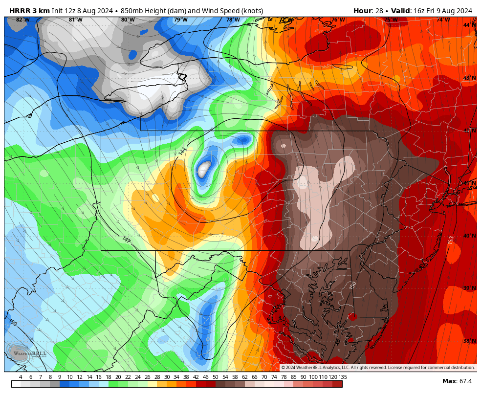
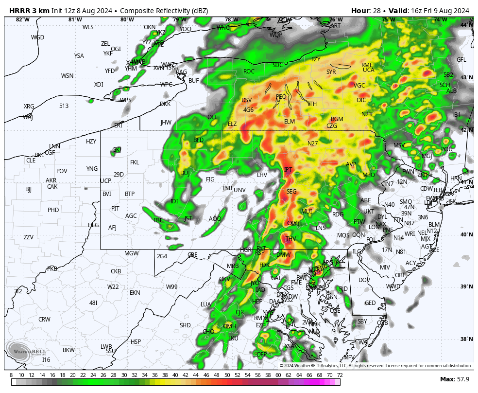
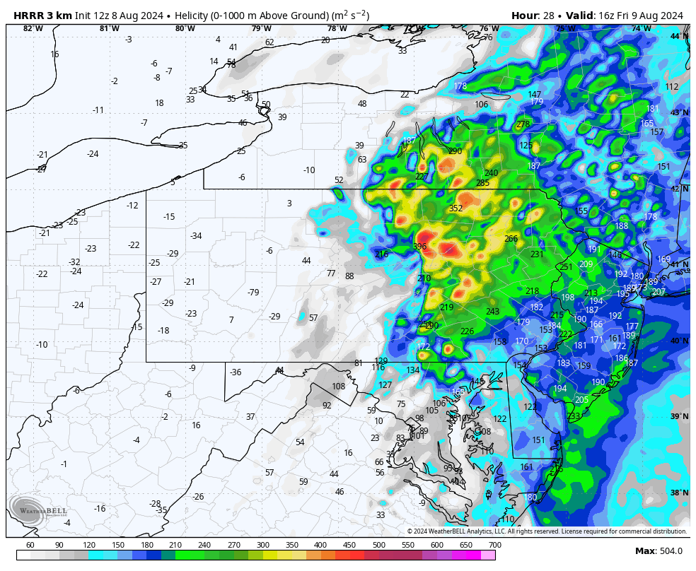
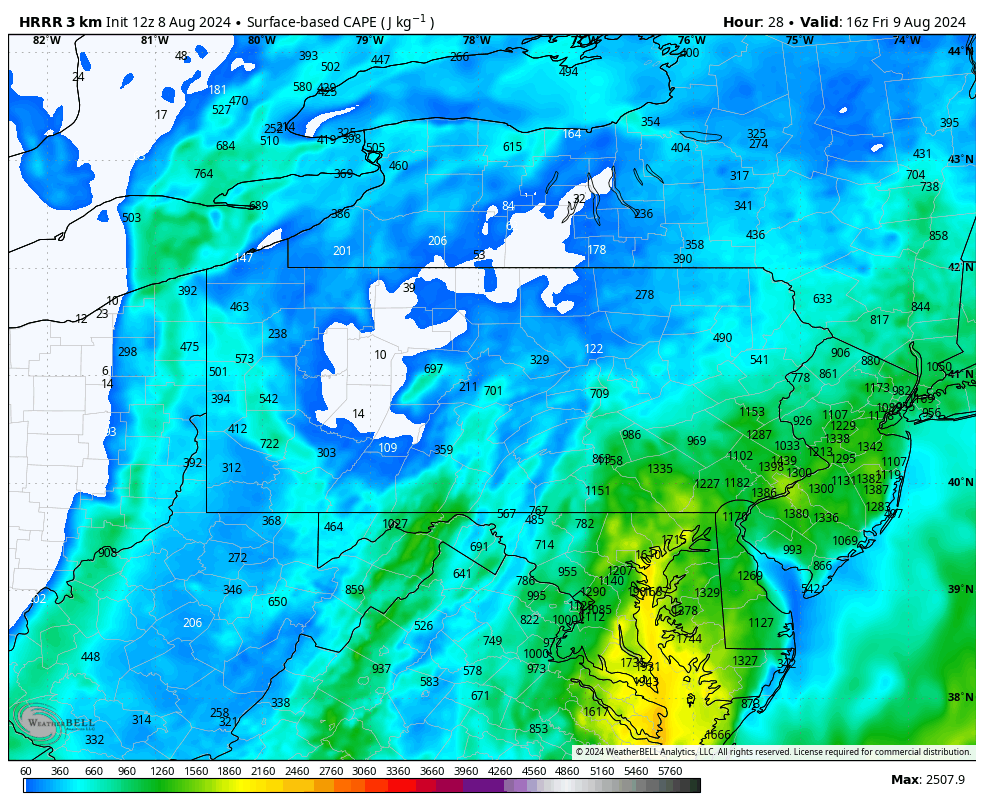
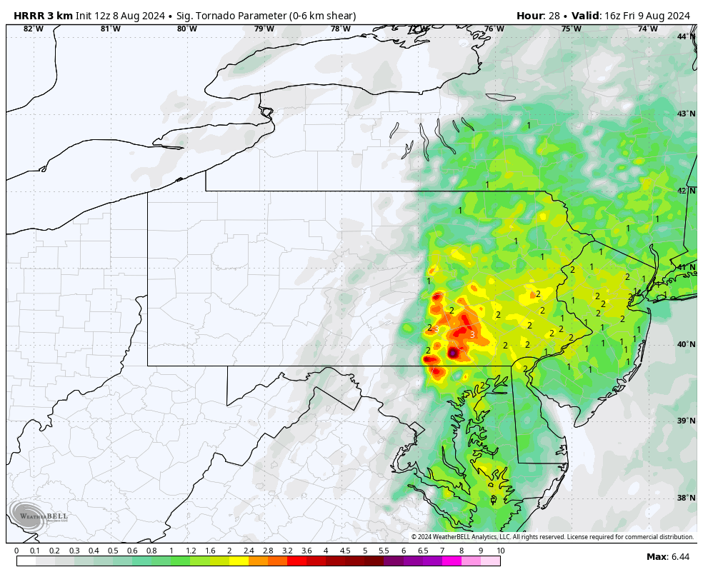
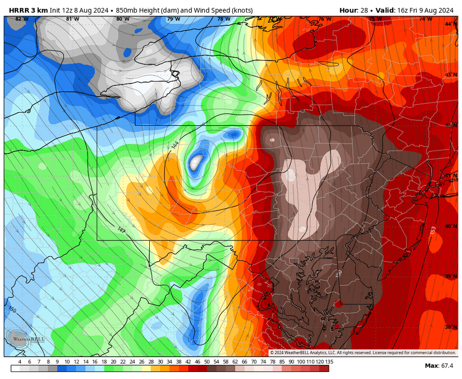
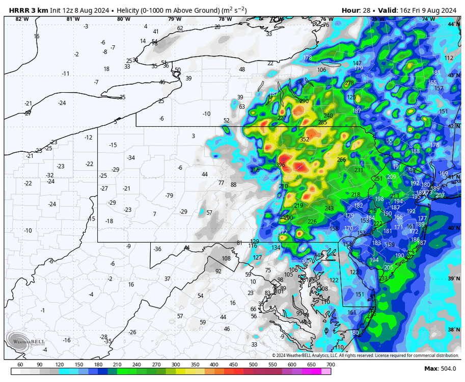
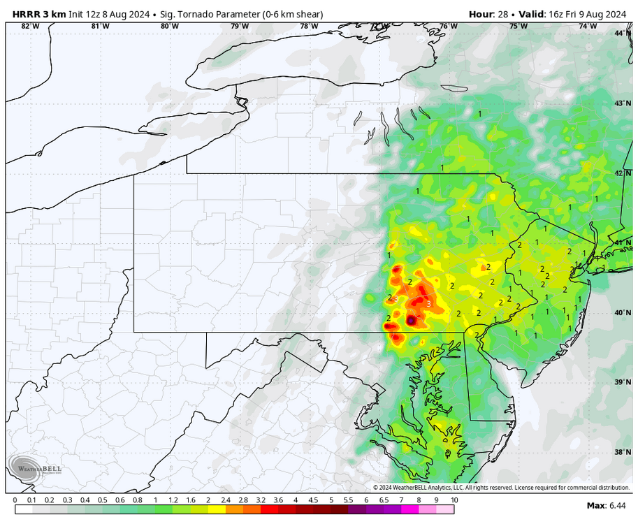
I’m kind of surprised SPC doesn’t have much in their outlook tomorrow for severe in Eastern PA. I feel like there’s a half decent severe threat (of the slight risk variety at least) for winds and brief spin ups. Using the new 12z HRRR here centered on 16z (noon) tomorrow, which I’ve noticed has really sped this event up. Simulated composite Radar: Screaming winds aloft at 850mb Very high helicity/shear, as per usual on the eastern side of a landfalling tropical system Modest but not excessive CAPE: Significant Tor parameter, which incorporates the shear and the CAPE So my interpretation is that the potential is there for severe issues for sure, especially if the HRRR take on having more of a distinct band/squall line is correct. CAPE is limiting factor on actually having cells capable of “significant tornadoes” but the parameter is spiked because of the very high low level shear/helicity. So I feel anything embedded in a band (or bands) will have the capability to bring some of the high winds aloft and potentially spin up some brief tornadoes. Didn’t include it with all the maps but even the 925mb wind speeds are modeled to be 50+ knots in the Sus Valley late morning tomorrow. Wouldn’t take much to mix it down. As mentioned before the HRRR looks faster with the progression than say the NAM. Could be too fast but it is a thing with TC remnants to move along once they’re interacting with a frontal boundary. That could be a limiting factor capping high end rain totals where the remnant core passes thru.


-
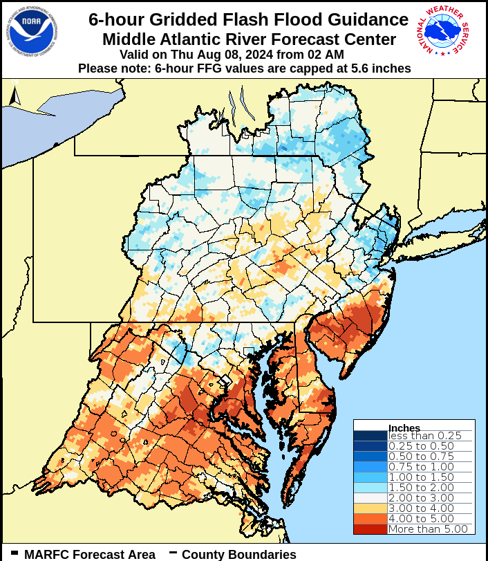
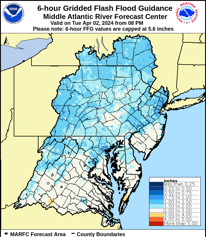
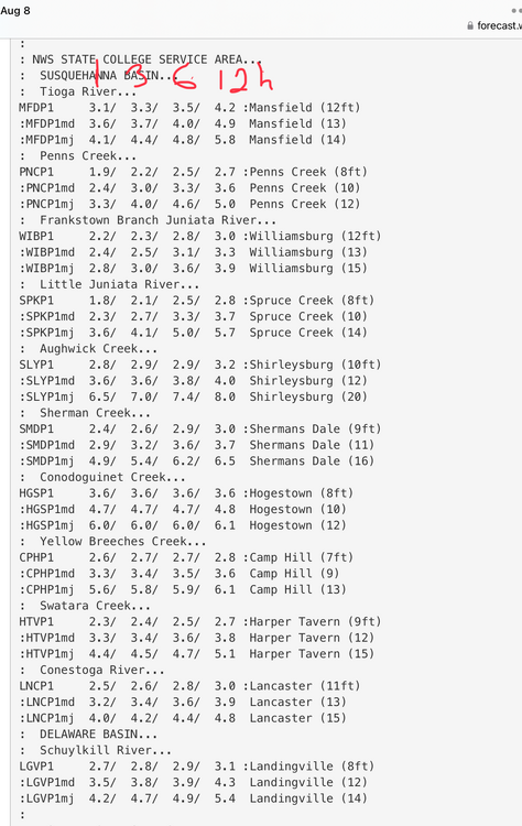
Some maps of note this morning. Updated flash flood guidance (6hr) Updated Susquehanna Basin Headwater guidance Of particular concern locally I have is with the Little Juniata and Frankstown branches of the Juniata River. These tributaries have some of the most attainable numbers for moderate and major flood categories and they’re colocated with the modeled passage of the remnant core of Debby, where these 3-5” totals are most likely (and likely most of that coming within 6-8hrs). I’ve personally had only 2.3” of rain in the last 30 days, with only 1.25” falling in the last 2 weeks… but 5-10 miles from here has been a completely different story with last Saturday and Tuesday having storms that have dumped 2-3” both times in the areas that cover a good part of the basins of those two tributaries.

-
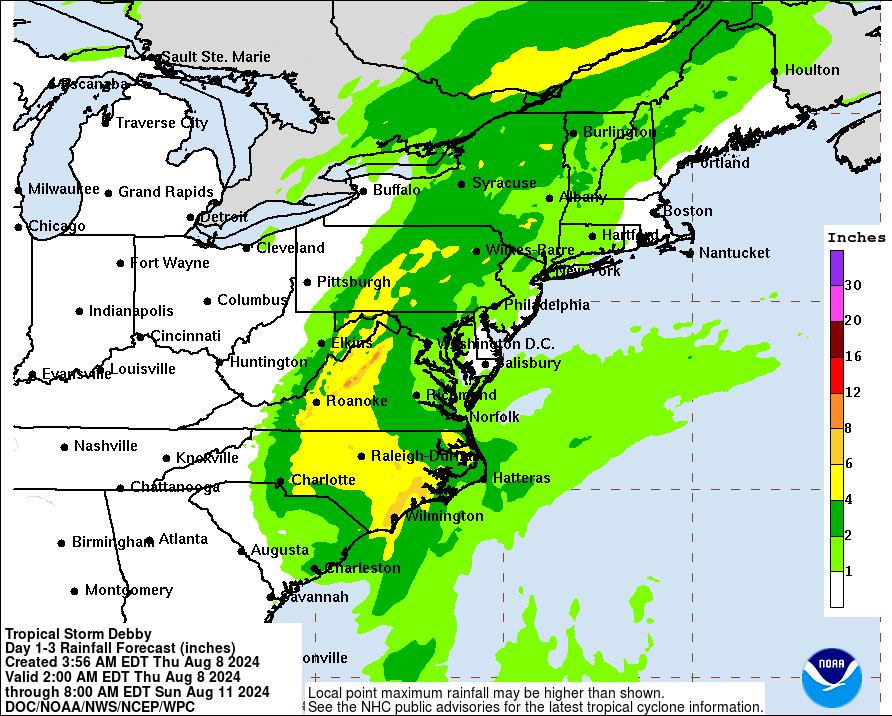
Still a good bit to be determined with regards to now Hurricane Debby’s eventual track/progression into the southeastern US and presumably further up the eastern seaboard this week. The certainty at this point is that this is likely to be an extremely prolific rainmaker in FL/GA/SC/NC. Most guidance tries to bring Debby back out into water off the GA/SC coast before making a second landfall, and then becomes the issue of what it does after that. There’s no real strong trough diving down to pick this up or anything, so it will be slow moving/meandering for a good portion of the week. I suspect the most likely scenario is it eventually gets drawn up the east coast late in the week in some fashion as generally suggested by the Euro/Canadian/ICON, etc. The GFS has been basically sending Debby directly back where it came from after it emerges off the GA coast and then stalling further towards AL and the FL panhandle. A possibility but probably a less likely scenario. In terms of eventual direct C-PA impacts. The Euro suite (op/ensemble/AI version) currently seem most supportive of the more traditional tropical remnant swath of precip tracking thru a fairly sizable portion of C-PA (best chances for bigger totals in the Sus Valley portion). The GFS/GEFS despite its unusual tracking would still eventually draw up significant moisture into PA anyways but not the remnant low itself. In the meantime we have a shortwave rounding the top of the ridge that will provide shower/thunderstorm chances centered on Tuesday night, as the ridge is centered west this week and we are positioned on the rim. This additionally could provide a swath of heavier rainfall somewhere in C-PA in the form of a more organized cluster of storms. This feature also probably figures to influence Debby’s track in some form as well, likely drawing her track back NW. But at the least, this feature provides the best chance of rain this week for western and central PA, where the current probabilities of significant rain from Debby’s remnants are less than that of the eastern third.
-
Been on a pretty rough run here at the IMBY level, if something fires up around here the last few weeks it finds a way to miss. 0.08” on the day and 0.46” last 7 days.
-
Sorry I haven’t posted much lately, I usually am busier during the spring and summer months but this year I’ve been especially so and haven’t had much of a chance to post. But otherwise all is well. It has definitely been hot enough haha. I’ve already had about 12 days of 90+ this summer to date here at home, with a max of 95ºF (twice) and several other days that were 88-89ish. Probably a fall breeze compared to some of the LSV this summer but definitely hot for this area. Only about 0.6” in rain since 6/28 and 0.44” of that came on 7/3. Hopefully that changes this week.
-
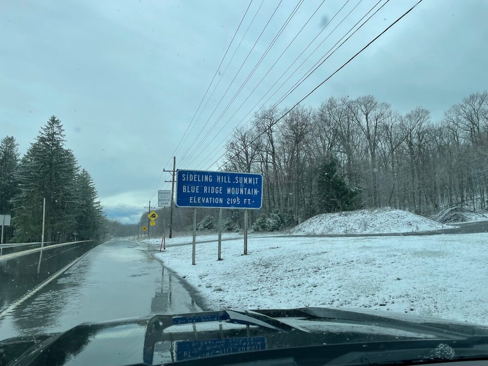
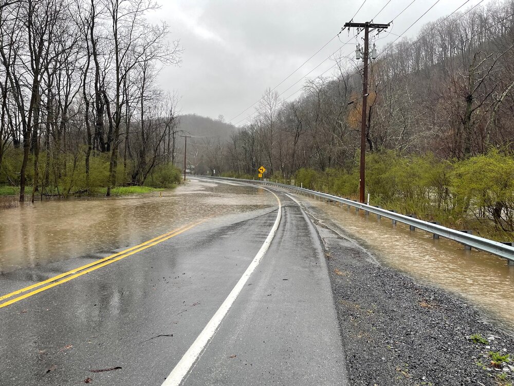
In my travels today this was Sideling Hill summit on route 30 in Fulton County. A little bit after 3 this afternoon.
-
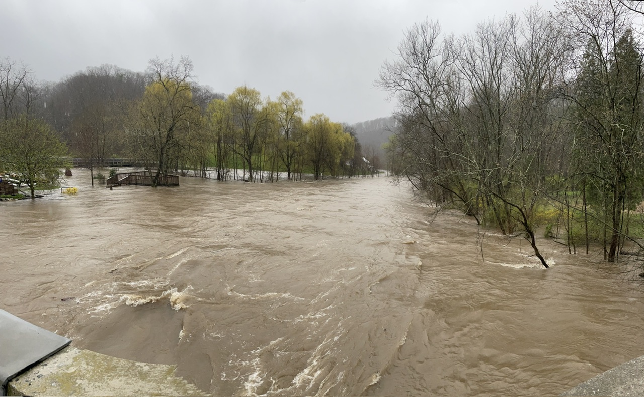
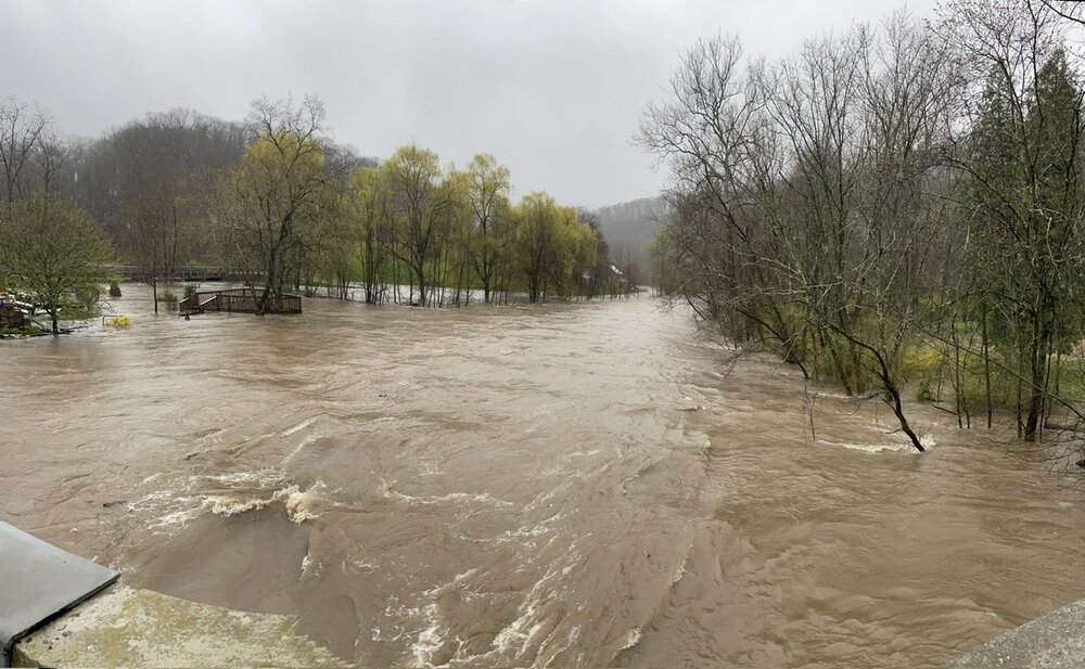
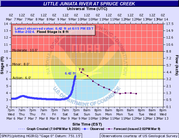
Still some lingering rain falling. Temps are also falling, now back to 39ºF. Event total rainfall here is now 5.08” since Sunday Night. There has been plenty of flooding issues today and closed roads. Frankstown Branch of the Juniata now cresting just inside major flood stage around 15.5 feet at the Williamsburg gauge. Little Juniata is receding, having crested mid-late afternoon in moderate flood stage at about 10.7 feet. Here was some pics I got just a little bit downstream from the Little Juniata @ Spruce Creek gauge around the time of it’s crest.
-
2.3” was the daily total at midnight. Already 0.67” since midnight. Flooding issues of the small stream and poor drainage variety are occurring again. Another significant wave of rain on the doorstep.
-
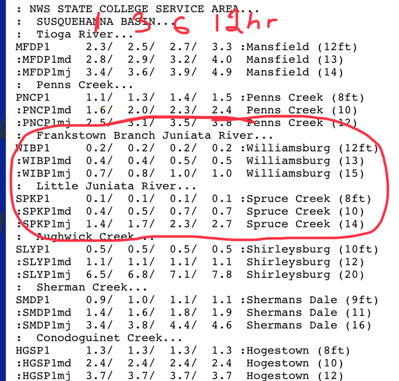
Approaching 2.0” for the day (1.98”) and 2.71” for the event. I’m legitimately concerned for flooding in the local tributaries around here given the new headwater guidance this evening and the amount of rain forecast to fall yet thru tomorrow. There were already some issues today and the Little Juniata had already edged above flood stage early this evening for a bit. The Frankstown Branch is highly likely to get to major, and the Little Juniata has a shot at major too, but certainly a moderate range crest looks increasingly likely. Both branches with that kind of response would likely mean issues on the main Juniata thru Huntingdon and Lewistown. Here’s the updated overall FFG for 6hrs in the MARFC coverage area.

-
Raining heavily currently. Total for just today is already up to 1.7”, with 0.71” falling Sun Night into Mon morning.. bringing the event total to 2.41” already. I anticipate some flooding issues around here, especially with more periods of rain to come through tomorrow.
-
AccuWeather’s got you haha
-
About an inch of snow fell here overnight, the biggest such snowfall since all the way back on 2/17.
-
32ºF and flakes flying, no accums currently
-
58ºF for high on this last decently warm day before we get cold for a bit, in response to finally having a period of significantly -EPO. After this week the grass is definitely awake, even saw a dandelion in the yard.
-
Just missed 70 the last couple days but it sure made it today. As high as 74ºF here so far this afternoon. Checked KAOO to see if it was a record day at 73ºF there and it apparently was not. The 80ºF daily record high in 1990 would appear to be safe.
-
Last night was blustery but not overly windy down here, but it’s been a different story this morning though since just before daybreak. My station registered a high gust of 59 mph around 715am and there’s been plenty of 40+ gusts.
-
More robust daytime heating at the surface over there probably resulted in higher wind gusts mixing down this afternoon. High res guidance increases the winds aloft overnight into the early part of the day tomorrow. So similar gusts are likely to continue. My high gust at home today is 32.4mph and most of the ASOS and RWIS around here (KAOO, KJST, etc have had max gusts in the 45mph range so far.
-
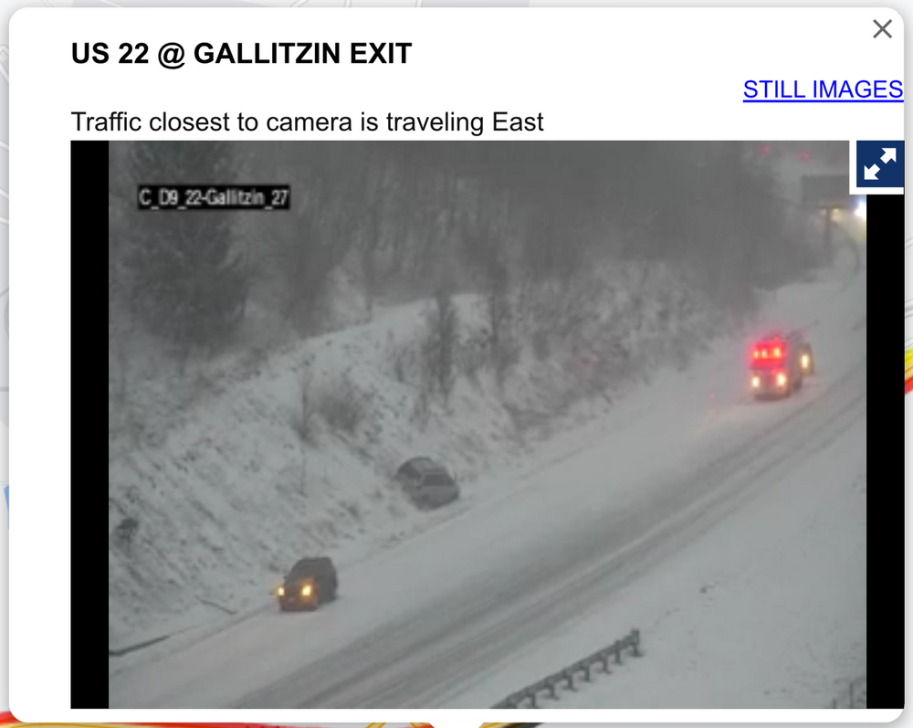
Laurel’s are looking pretty rough, specifically on the US 22 corridor right now in Cambria at the top of the mountain above Altoona. Pretty wintry down here too, with a coating of snow on the ground and occasional heavier snow squalls blowing around. But roads are uncaved at the moment. Temp is 30ºF
-
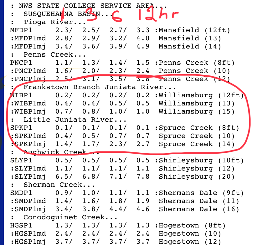
I’d imagine the gauge station down the road from there near Spruce Creek will get above flood stage and they’ll need an actual warning for that branch which is the Little Juniata. Moderate flood stage at 10ft is roughly the benchmark for the road caving to the river along that stretch of 453. r Frankstown Branch follows 22 to Hollidaysburg, that one might be close to needing a warning too. This has probably been the highest QPF event of the winter around here outside of the 1/9 warning snow to 1”+ of rain. Got 1.65” in the gauge with one more wave of rain to get through this eve.
-
Certainly an advisory looks probable there, and possibly some of the other counties in western PA along I-80 outside of the snow belt immediately off of Lake Erie. Temps at elevation in the Laurels look to be plenty cold (falling into the mid 20s Sunday), so snow will likely pile up once it gets going. Once east of the Laurels likely nothing major accum wise, however there could be some potent squalls that traverse the central counties on Sunday. With regard to WSW potential, duration is likely a factor in probably not seeing amounts like that in the Laurels outside of the very highest elevations. The back lash event itself looks potent though, with -10 to -12ºC 850mb air coming across the well above average and unfrozen lakes. Couple that with March solar and daytime instability and I think we’ll see some long reaching squalls and potential snow squall warnings especially in the central part of the state as mentioned. Surface temps in the Sus Valley will be warmer but anything stronger that makes it over there will likely crash temps and become snow.
-
60ºF was the high here today, mosquitoes are out for blood.
-
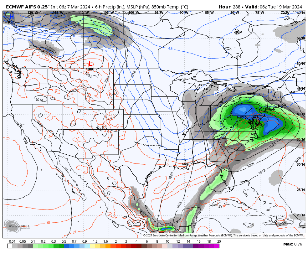
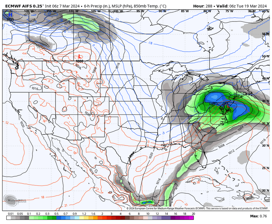
I don’t usually post snapshots of ops in the long range but might as well throw this one in here with the other maps. This is the new AI generated Euro model. I saw the Mid-Atlantic folks sharing this occasionally down there and now WB has put it on their site in the last day or so. So there’s that.. it is nice that it goes all the way out to 360 on all 4 daily runs. Also noteworthy is that it has been very cold in the D10-15, with major negative departures in Canada getting into the northern US. So will be interesting to monitor how this does. Perhaps the AI Euro has “learned” that the 3 out of last 4 winters being garbage winters all produced garbage springs too haha. With two of them (19-20 & 22-23) producing snows in some portion of PA in May and the other one (21-22) with a snow event in the central counties in late April. At any rate, ensembles have been clearly showing a major nosedive of the EPO during roughly the 3/13-3/17 period and staying solidly negative for at least several days beyond that. So that period around St Patty’s thru about the 23rd is likely one to watch. This transition of the EPO is pretty well within the ensemble range where there would be some skill in forecasting, so barring any major changes in the near term (possible of course) it would appear this pattern shift will occur despite what the MJO is doing. I think the question will be how much cold air gets involved and how long the -EPO regime lasts. That will have implications on how cold/warm the rest of month into early April is. The MJO pulse is a pretty strong one, but is forecast to move quite rapidly from 4 to 7 pretty much in the next 10 days. So I wonder if it’s influence on our pattern might be tempered a bit by its rapid progression.
-
Only 55 and low overcast here. The valleys are really doing their thing today with the cool air damming. I bet all I’d have to do is drive to the top of Wopsy to get into the sun.