MAG5035
-
Posts
6,078 -
Joined
-
Last visited
Content Type
Profiles
Blogs
Forums
American Weather
Media Demo
Store
Gallery
Everything posted by MAG5035
-
I’m intrigued by it. The first northern branch system goes north of PA Thursday, reinforcing some decent cold to be in place for the Saturday wave and it will already be a good bit colder this week in the wake of today’s system. Despite it being much colder, the low track north of PA with Thursday’s system will drive a brief surge of warmer surface temps (upper 30s-low 40s) that would likely be mostly light rain at lower elevations prior to frontal passage. Today’s system had a bit of a front running wave Sunday that might have had a hand in setting the boundary further south that the main wave ended up running on. So the Thurs wave evolution is going to have to be watched to see how it sets things up for Saturday, among other things like timing of both these features and jet stream interaction.
-
I’ll have to melt out my Ambient rain gauge to see what kind of number I get. Going off pasty consistency of snow it’s likely a 7-8 to 1 type snow. The best deform snow missed here to the south and east, so we had a nice moderate rate mostly but not intense snowfall. That took a bit to start piling up. You were under the good FGEN forcing, so while 850 and 700mb temps weren’t ideal they were probably cold enough to generate a slightly better than 10:1 ratio in terms of crystal growth. Surface temps matter to a point, but when it pours snow and starts piling up you can get decent fluff factor on marginal surface temps with good snow growth aloft.
-
I noticed that, I was looking at the 511 cams up there a bit ago and the one that’s at the actual Woodland exit on I-80 has nothing at all on the ground, and the Woodland camera on 322 that’s probably like a mile or so from the interstate camera looked like it had a coating.
-
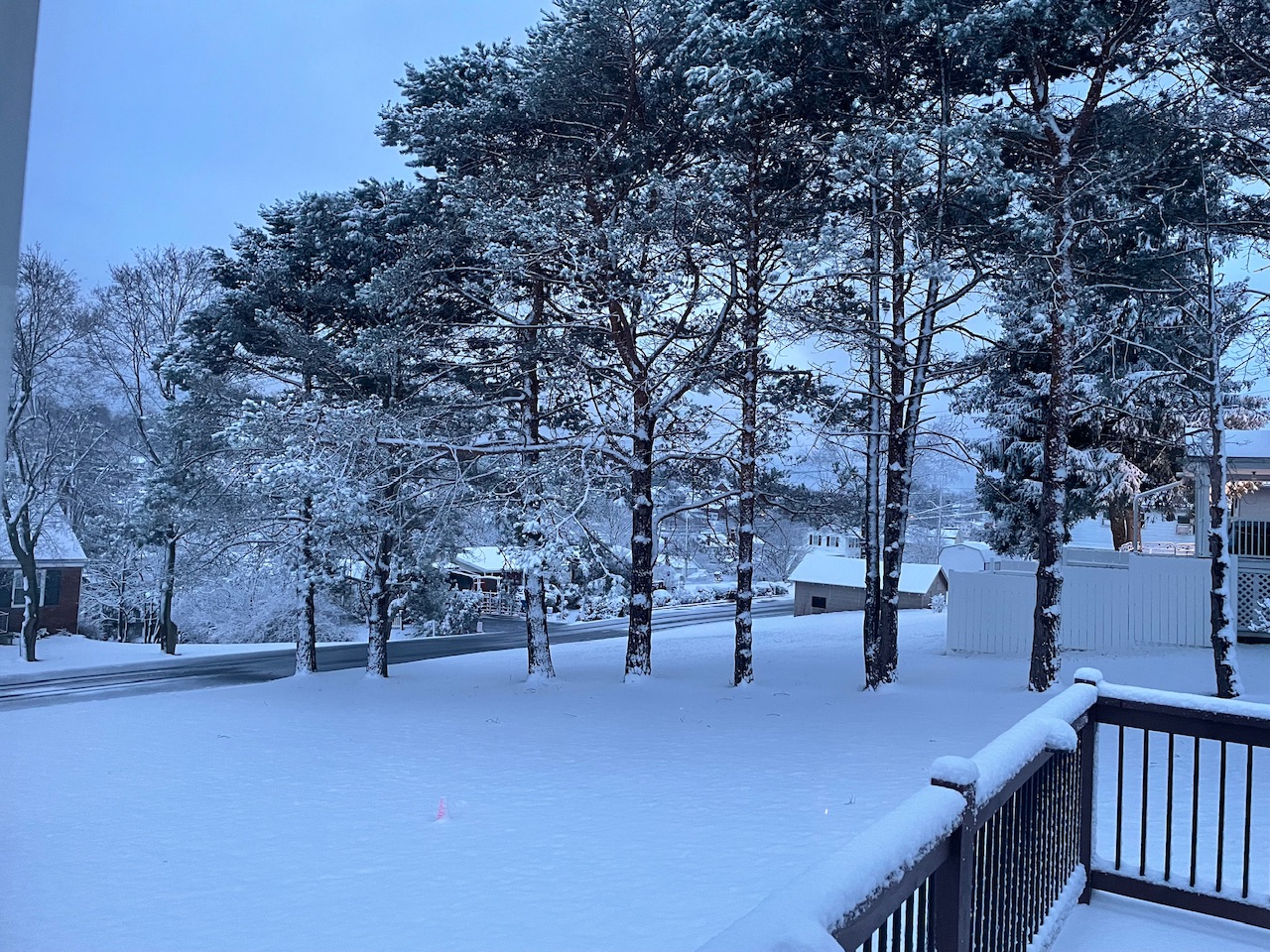
The obligatory daybreak snow pic

-
I’m out of the snow now over here, only about 2.3” total.
-
Temps down to 32ºF and moderate snow. Accums starting on the grass.
-
Snowing in State College on the 511 cams. They also show the road caving already in the 7 mountains region east of State College on US 322. Really wet snow falling here, not accumulating yet. Temp/dewpoint down to 35/33ºF.
-
The really heavy echoes have gotten overhead here. Mixed rain and wet snowflakes and 38ºF/34ºF
-
Referenced in their 1109pm update.
-
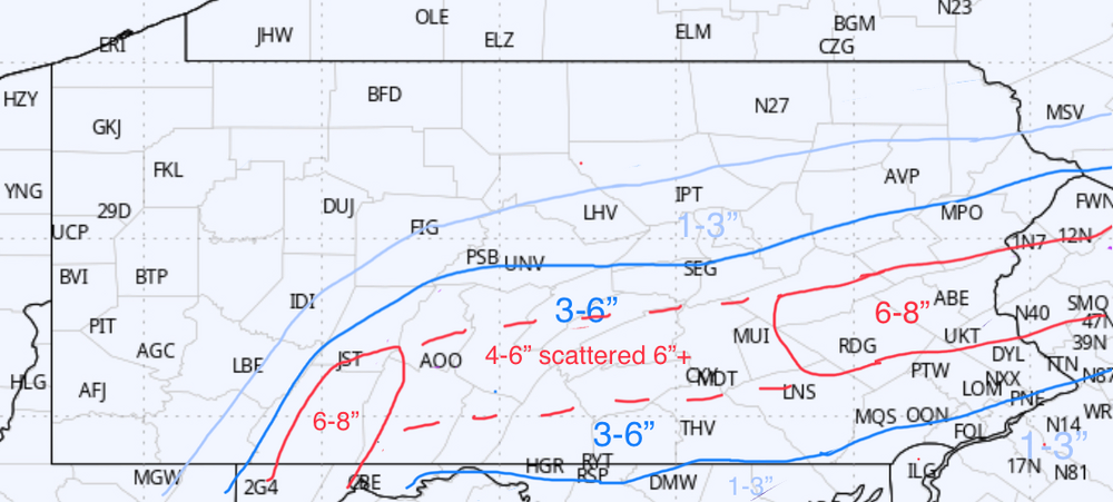
Okay better late than never. My one and only call map wise. This is a major change from what was in my head 24 hrs ago. Stayed a little bit generous on northern edge in case things trend up north a little bit better in the very near term. Straddled the 3” line near the M/D line. Toned down top end as well, though there could definitely be some 8”+ amounts scattered anywhere in the red area.
-
40/31ºF here with a little bit of light rain/drizzle. Light NNE breeze.
-
HRRR has quietly been involving a lot of the Mid-Atlantic folks from DC north with solid accumulating snow today, especially the newer runs. I think that’s rather ambitious but shows how far south this things have shifted heavy snow swath the last 24 hours or so. Those folks gave up on this event days ago.
-
Still warned here.. for 2-4” haha. Not sure I’ve ever seen that before other for additional snowfall on an already ongoing event. These are 6” counties for warning criteria.
-
Always got to give the hat tip to the Euro haha. If the current Euro depiction were to come to fruition the real winner is the Canadian/RGEM. That’s the kind of solution it constantly showed while the other globals including the Euro had the bigger swath of totals. Never really has embraced the big totals even now, though it has warning totals well east of C-PA. I dunno.. event’s got to occur first. I don’t plan on crowning ANY model for this one, but it certainly wouldn’t be the Euro if I did. Meso models are going to handle the FGEN induced band of snow better than the globals at this point. I’d be surprised if there wasn’t at least a 4-6” swath coming across. Things can stop shifting south and tightening though, I never really thought I’d be in danger of being out of this event back this way (Altoona/State College region) but wow we’re there right now according to a lot of guidance. Lighter rates outside of the main FGEN induced area of heavy snow are going to be hard to get accums going coming into this event warm.
-
The progged evolution of the low has appeared to change some. Might not be truly one but it’s more of an A look than a B look now with the low mostly just going right to the coast and deepening pretty far south of PA instead of a distinct primary trying to cut thru WV towards western PA. That’s what really cuts QPF and really sharpens the gradient on the NW side of the storm in western/north central PA. It also is what now puts the whole Sus Valley back in the game. Said yesterday the dynamics are there to snow whereever in PA that swath decides to set up, irregardless of elevation. There’s going to be intense rates in that banding. It is going to be moving pretty fast either way.
-
Boy if we see this all the way through with where things are at currently this would be one of the biggest shifts south in the short term I’ve seen for around here anytime lately. Some of that high res guidance suggests several of those northern most warned counties don’t even see a flake of snow and folks like atomix and 2001kx are right on the edge.
-
And to think we started the day ready to crown the ICON for being right having the heaviest snow all the way up along the NY southern tier lol. CTP was smart to keep their remaining watches up.
-
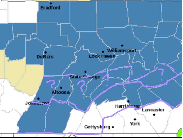
I’ll probably draw up a snowmap for this sometime tomorrow, most likely after I see 12z guidance. I don’t do the “first guess”, “first final guess”, “second final guess”, “actual final guess”, etc haha. Where am I at with this currently? I think I-80 corridor and a bit north of there is favored for the big totals right now and big totals being an 8-12” type with some scattered higher totals. This is gonna hit hard where the banding sets up. And that’s really the big thing about this ticking north. Dynamics with this thing transferring to a rapidly deepening coastal and likely heavy banded precip is enough to snow wherever in CTP. But if primary climbs too far before that occurs then the best banded precip is north… which is kind of where the models headed the last couple runs (esp yesterday). This is my take on headlines right now, I drew out where I think advisories probably should be. The 6” line is probably somewhere within these question mark counties.. but I’m not sure if it’s going to cover enough of those counties to warrant a warning yet.. hence the question mark.
-
Gonna touch on the pattern a bit before happy hour. Still much to be determined second half of the month with continued wild variance on operational guidance. It seems forgotten by some how hard it is to hone in on things in a blocky pattern with a myriad of different features in a split flow. One thing that is showing persistently in the 6-10 day period is a hard dive in the EPO to significantly negative anomalies starting in the wake of our departing system Tuesday. With -NAO/AO and +PNA ongoing, this presents an opportunity to inject a cold shot into the pattern… which the Euro picks up on as well as the GFS to a lesser degree. That seems to center near the P-Day period, whether we can will the available southern stream system into PD3 or not. EPO neutralizes near 2/21-22. The pattern looks active storm-wise too in that Feb 15-25 realm. I think the only sure prediction is expect a lot of chaos trying to nail down individual features. I think at the least we get a cold period similar in length and anomalies to what we had in mid January. Big question there being of course whether or not we can carry a more consistent colder than average pattern into the first couple weeks of March. If I had to put numbers out for March (which I will be in about a week) I currently am leaning colder than average March overall with some opportunities, but that may come with another warm period in the pattern towards the beginning of the month. Just throwing some initial thoughts out. Ultimately, I think things are still mostly on track with what I have personally posted about regarding the pattern this month. I expected a very warm front 10-14 days of the month since mid-late Jan and here we are. Near V-Day for a more favorable pattern was my target and the fact that we have a system in play a couple days prior is a bonus. From my Jan 31st post on top of page 251:
-
Euro has bumped it’s swath north the last couple runs, matching more of a GFS type swath. The difference being the Sus Valley when comparing GFS v Euro accums.. and GFS is def not my go to if I have to use a global to determine snowfall in the Sus Valley. Euro is probably a better representation of what’s going to happen snow wise with its solution at 12z. 12z vs 0z runs Stronger primary that pushes just a bit further north and keeps things aloft just a bit warmer. I’ve said or at least implied we don’t want to get this to being a longer period of rain to snow changeover event in the southern tier. It’s not the path to success for the Sus Valley with this (or even over here for that matter). Just commenting on the solutions at face value here. There’s not much of a consensus to be had for this cycle op wise. Cold NAM with forum wide snow, GFS/EURO with heaviest swath I-80 and north, UKMET with a southern slider that snows I-80 and south, Canadian with NOTHING, and der IKON so far north that plowable snow is NY border counties and north.
-
Nah you guys are looking pretty good right now, and I don’t anticipate p-type issues up that far. All guidance/ensembles not named the ICON (furthest north outlier by far currently) has Williamsport near or within the swath of best snows. Euro and GFS ops have had IPT getting 6”+ and GFS has been putting out double digits there the last several runs.
-
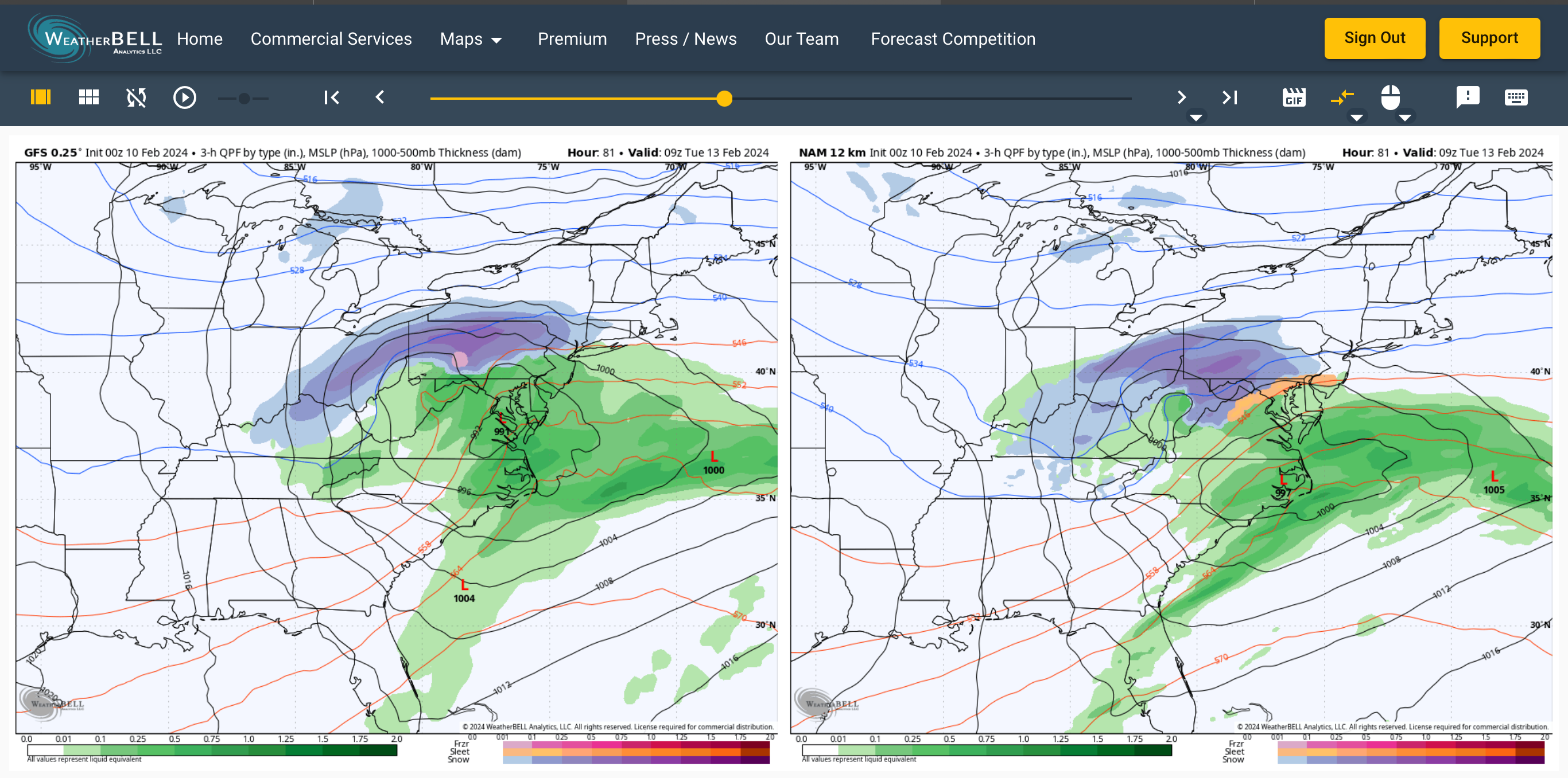
0z GFS coming in similar to 18z (and 12z). It may have shifted its 6” line like 10-20miles north in the Sus Valley from 18z, essentially back about to where it was at 12z. Focus on I-80 corridor on north for the axis of heaviest snows has been persistent with that op 0z Canadian looks nice with snow shield placement on the southern 2/3 of PA. Still on the lower side QPF wise and a bit splotchy with its output on accums but it has come a pretty long way from where it was having a very weak system. I started this post to comment on the NAM, but ended up commenting on the rest of early 0z guidance in the process. At any rate, NAM at range disclaimers aside… I have noted in the runs today that it seems to be on the colder side of guidance overall. Probably the coldest to be honest. I generally put heavier focus on the high res stuff for thermals (3k NAM, HRRR, etc) when things get in range to start using them. We start setting the boundary during Sunday, basically in the 48-60hr range at this point. So this is going to be really something to watch as we set this event up. The entire NAM column in PA is colder, but where it is especially so is up on the column at the 850 and 925mb level. 850 mb temp difference between NAM vs GFS is huge. 81 hours, where the event is pretty well underway in C-PA (GFS timing a bit faster) Now look at the 850 temps for that frame. Is the NAM onto something here? I’ll be curious to see if it holds onto anywhere near that cold of a profile as we get closer into range. Just a few degrees is going to make a big difference in this event, especially in the Sus Valley. Even a compromise of the thermal profiles between these two solutions likely get the subforum a decent event… and the GFS solution is still mostly a C-PA snow event anyways with the question mark of changeover delivering decent snows being the southern tier (turnpike corridor and south). The NAM at face value actually implies something that could be a notably >10:1 ratio event with the -8ºC 850mb isotherm deep into central/southern PA. I still feel in PA the heavy swath is a 6-10” type deal, but a NAM solution would be how double digit totals get introduced.

-
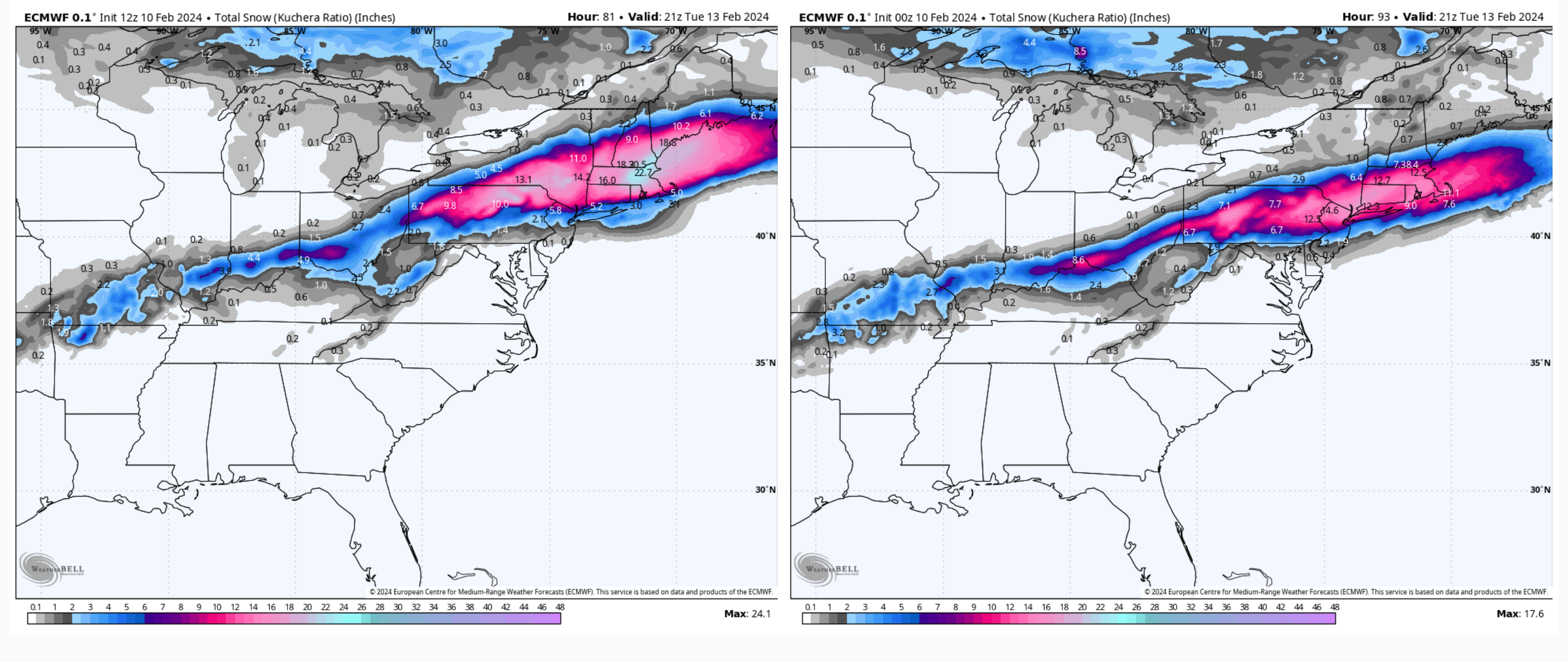
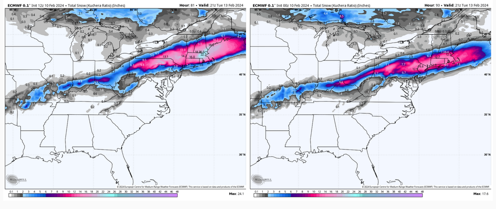
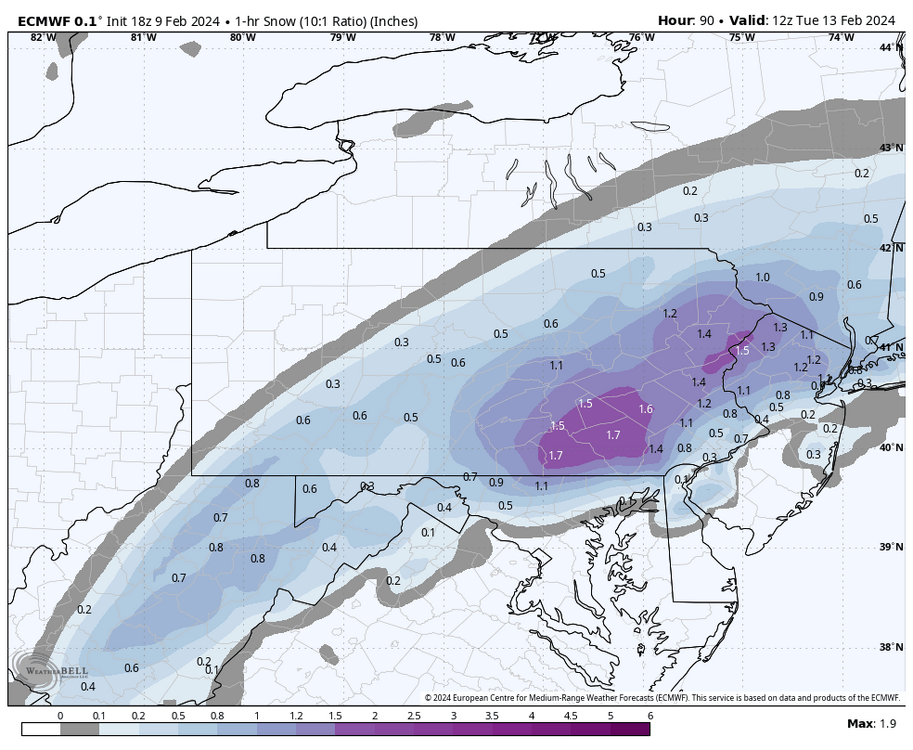
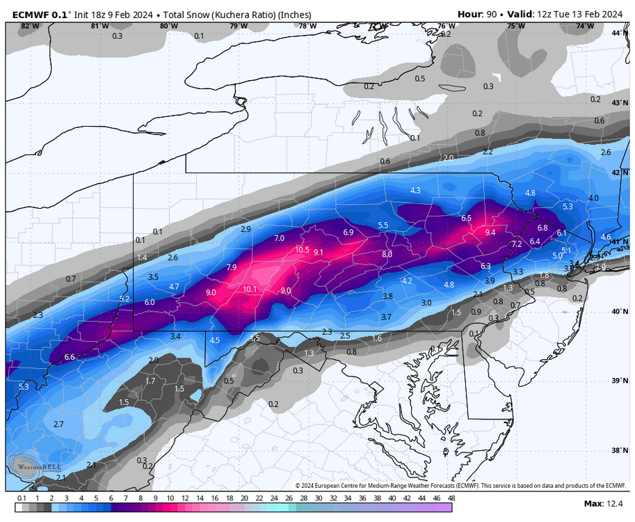
It’s a good run for sure, still snowing at 90hr in most of central/eastern PA too and quite heavily in the LSV. 1hr snowfall at the 90hr frame: Total snowfall thru 90hrs
-
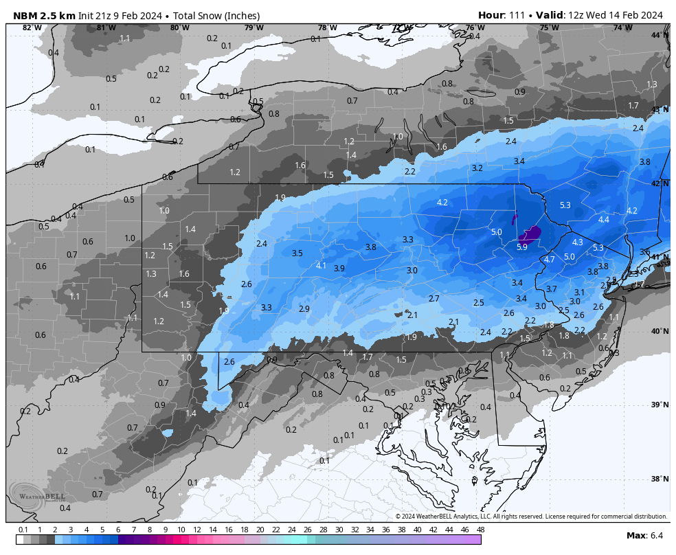
Here’s the NBM (National Blend of Models) for reference. Whenever it comes time for CTP to throw out an initial snow map, NBM is likely to factor a good bit into their map. I think this particular blend actually looks solid for the time range we’re in (D3-4). We’ll see if it eventually starts matching up some of the bigger numbers the ops are throwing out.

-
The Downfall video, lol