MAG5035
-
Posts
6,078 -
Joined
-
Last visited
Content Type
Profiles
Blogs
Forums
American Weather
Media Demo
Store
Gallery
Everything posted by MAG5035
-
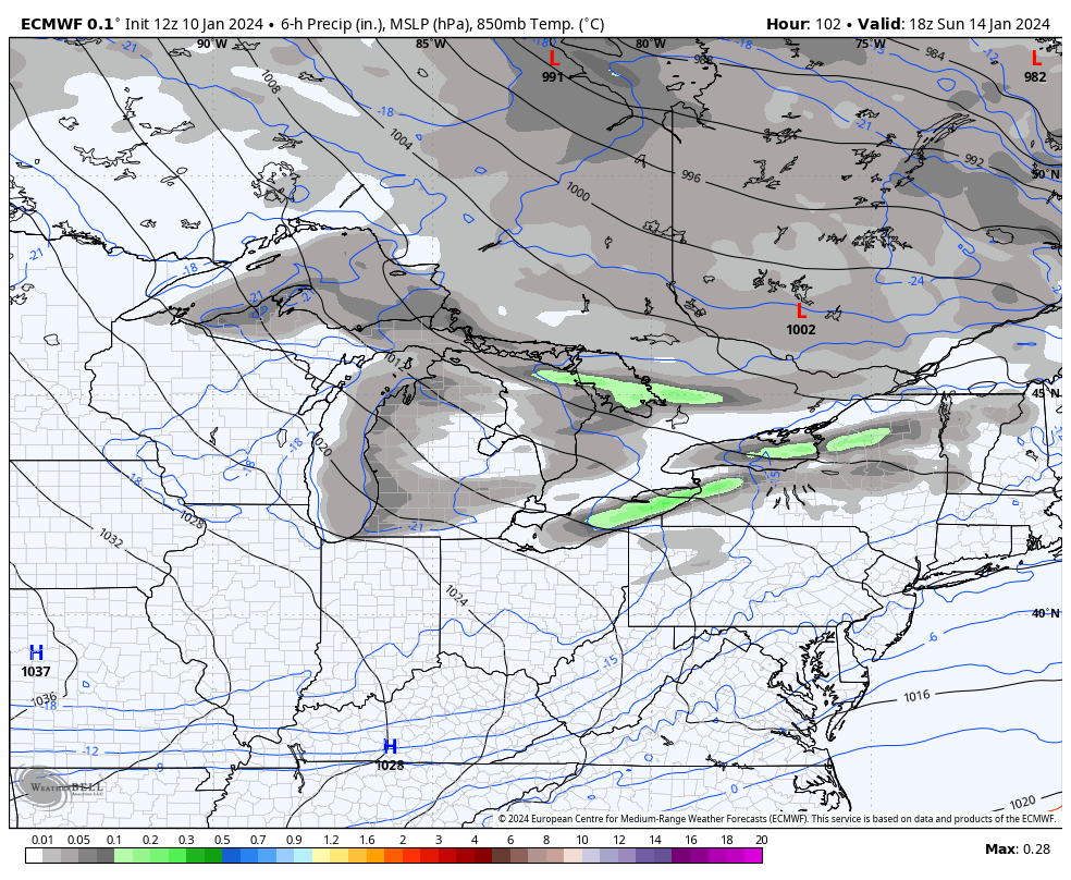
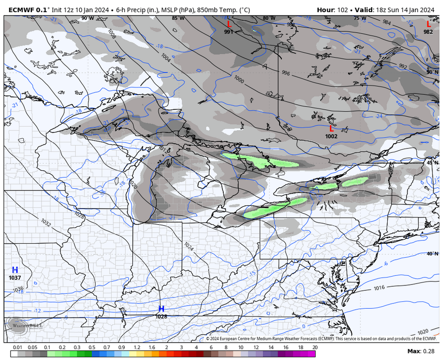
18z Euro ensemble mean/probs were in the ballpark of how it was 12z (a tad better in PA with 1”+ probs, while the Euro control at least had a system of some substance this go around with a wave of light snow thru PA and a swath of 2”+ I-95 corridor and east.
-
The 500mb differences in the Euro v GFS today were massive, not only in the timeframe of the Tues event but beyond it. I’m using 12z so i can do the Euro v GFS side by side (18z GFS was similar to 12z) GFS has a much more defined western ridge axis that extends all the way up thru BC while the Euro has a shortwave diving into Washington really dampening the ridge. The more amplified GFS allows the shortwave trough axis to rotate and generate our east coast storm. We’re going to have to continue to resolve thru the handling of these features, but certainly a sizeable event is on the table. If we amplify similar to the GFS I will note the position of the western ridge axis on the west coast. C-PA ideal positioning is the ridge axis thru Boise, ID… so it’s a little bit west. Given the cold on the playing field I think this is still okay but if we amplify a bigger event I don’t think we’d be fringed.
-
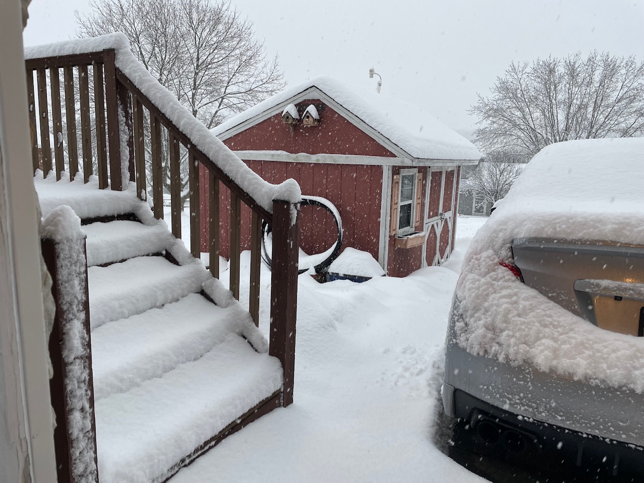
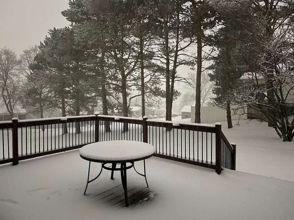
Some finals from yesterday’s storm. 1.47” total as measured by the rain gauge (WS-5000 station), which includes morning snow that piled into it. I brought the rain gauge inside and got the snow quickly melted. That only yielded about 0.4” which is likely too low, that would’ve been a 17.5:1 ratio at 7”. Ratio was probably close to 10:1, so precip total with the inch of rain was probably more in the 1.75” range. Pressure bottomed out at 983mb around 9pm last night, a drop of 41mb in 24 hours. Peak wind gust (this afternoon) of 42 mph. It was pretty windy today but nothing crazy despite the early morning upgrade to high wind warning this county had today. Still generally 6” of snow in the yard, except under the pine trees at the edge of the property. There was about 3-4” of snow left from Saturday prior to yesterdays snow.
-
I’d make a solid wager on it becoming very newsworthy in the sports media as it gets in the short range and BUF starts putting out products and accumulation forecasts for it (significant LES already being mentioned in their AFD). Although I’d probably make a solid wager on taking the Steelers at +10 too haha. But it seriously looks like a great setup for a major LES event. It’d be the first widespread one of the season with legitimate cold air over the unfrozen lakes too. I posted a map a few days ago and things look about the same with that WSW flow over the length of Lake Erie focusing on the south towns of Buffalo (where Orchard Park is). Aligned cyclonic WSW flow all the way up through 700mb. Low level 925 and 850mb temps in the -10 to -18ºC (ideal range for snow growth) over water temps in Erie that are mostly in the upper 30s to near 40. Timing is right around game time too and during Sunday. It could be a quite a spectacle.
-
You might be getting some local downsloping off whichever ridge is just east of Rouzerville (not familiar with the names down there). Velocities in that orange are 80+ mph and beam height around where you’re at is at about 4k feet (about the 900mb level). Which by the way, using LWX here but I haven’t seen that kind of velocity presentation on CCX radar since Sandy.
-
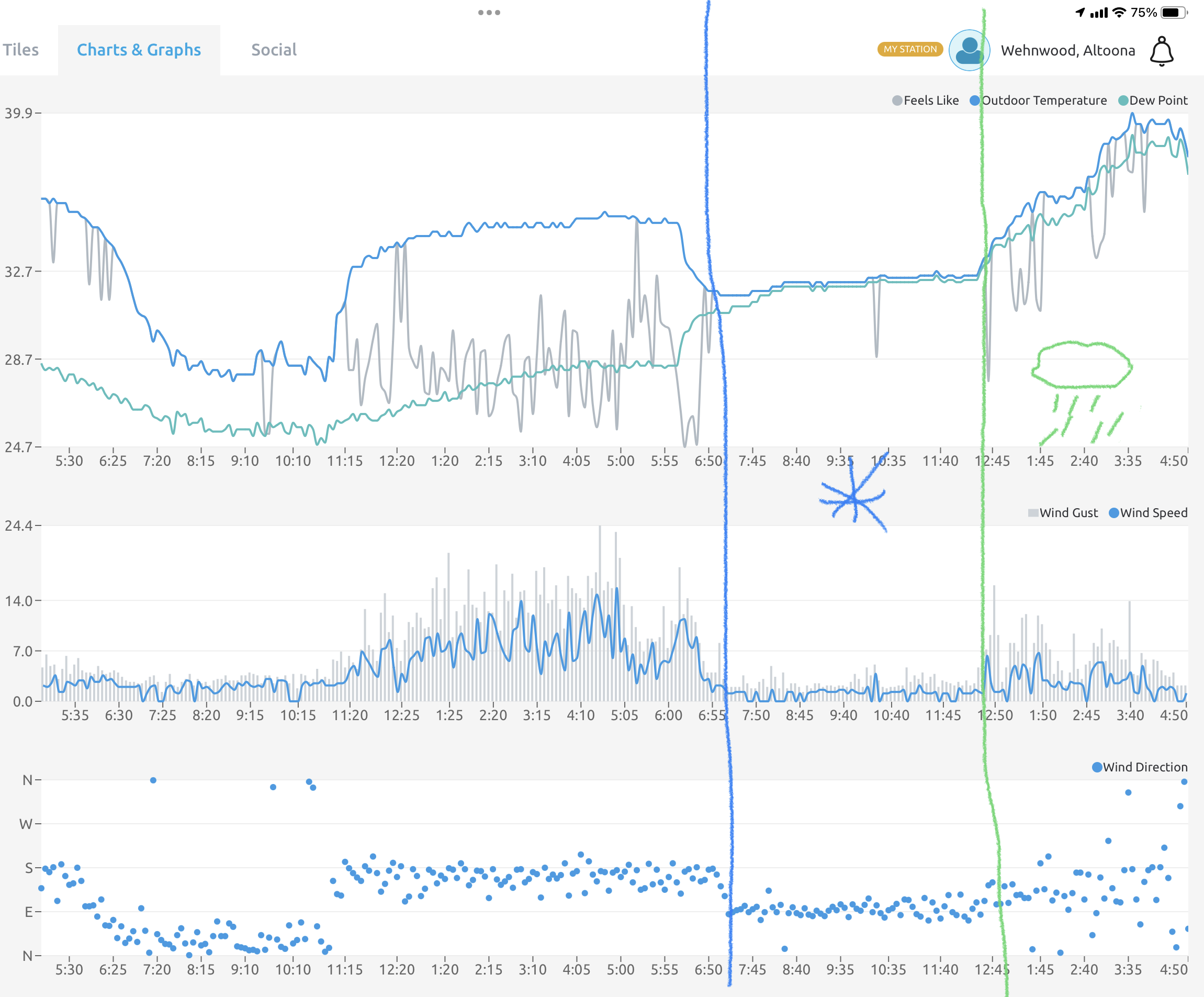
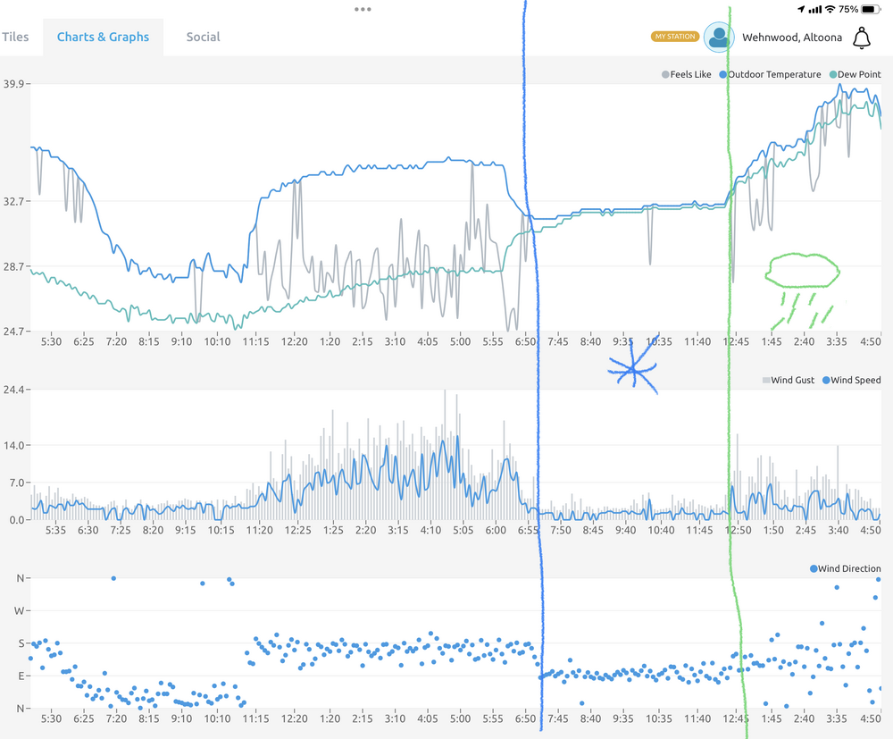
There’s been very little wind here all day. The snowpack has helped with keeping a stable cool surface layer. Peak wind gust on my station was 24.4mph which happened pre-dawn before the precip arrived. Only some mid-teens gusts occasionally this afternoon. Precip onset and changeover points are easily noticeable on the weather station obs with the wind direction changes and the temp/dew. Not to mention you can see the first half of last night where there was rad cooling and the temps spiked above freezing when the wind kicked up out of the south.
-
Finally gave up the good fight in the last half hour. Transition to rain at 33/33ºF. Final snow total was 7”.
-
Yea this is a really unique setup, CTP had noted a lot of mixing at the office there in State College. It’s almost like a valley to valley difference. I briefly had mixing when I made that report at 915am, figured that was going to be it. Then it went back to snow and it resumed piling up. The CC product is starting to close in now, so it won’t be long. I actually am just starting to hear some pings.
-
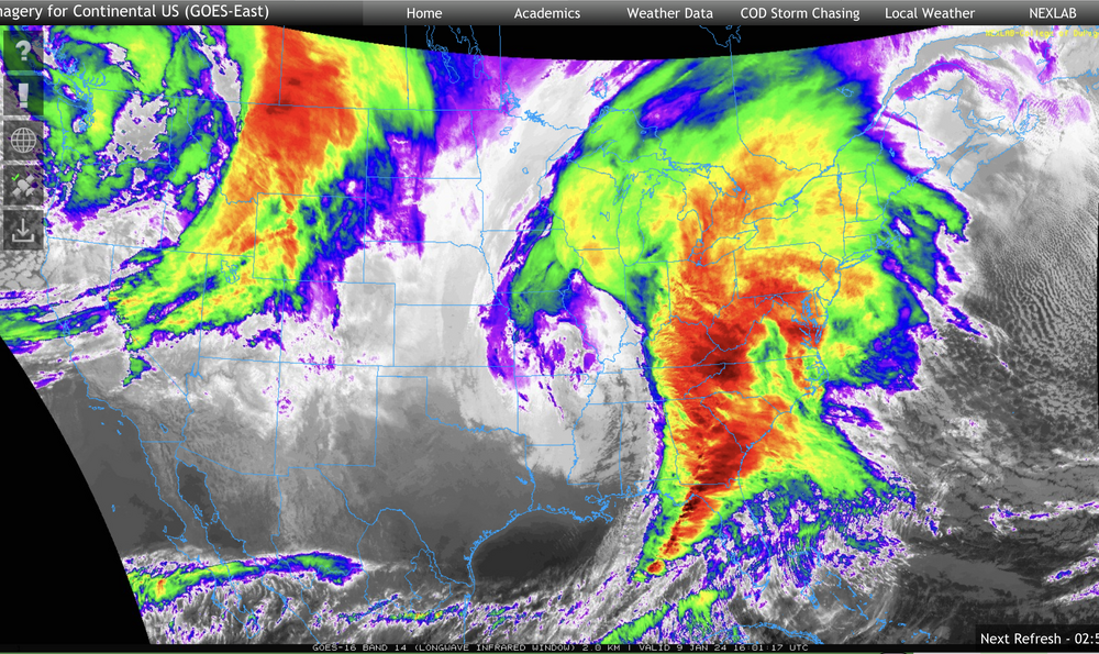
That 4.3” report at 915am was from me, and I reported 6” to them when i reached it a little while ago. That is a pretty wild disco with the CCX radar, likely a result of the record anomalous moisture influx from the Gulf. What a presentation on satellite
-
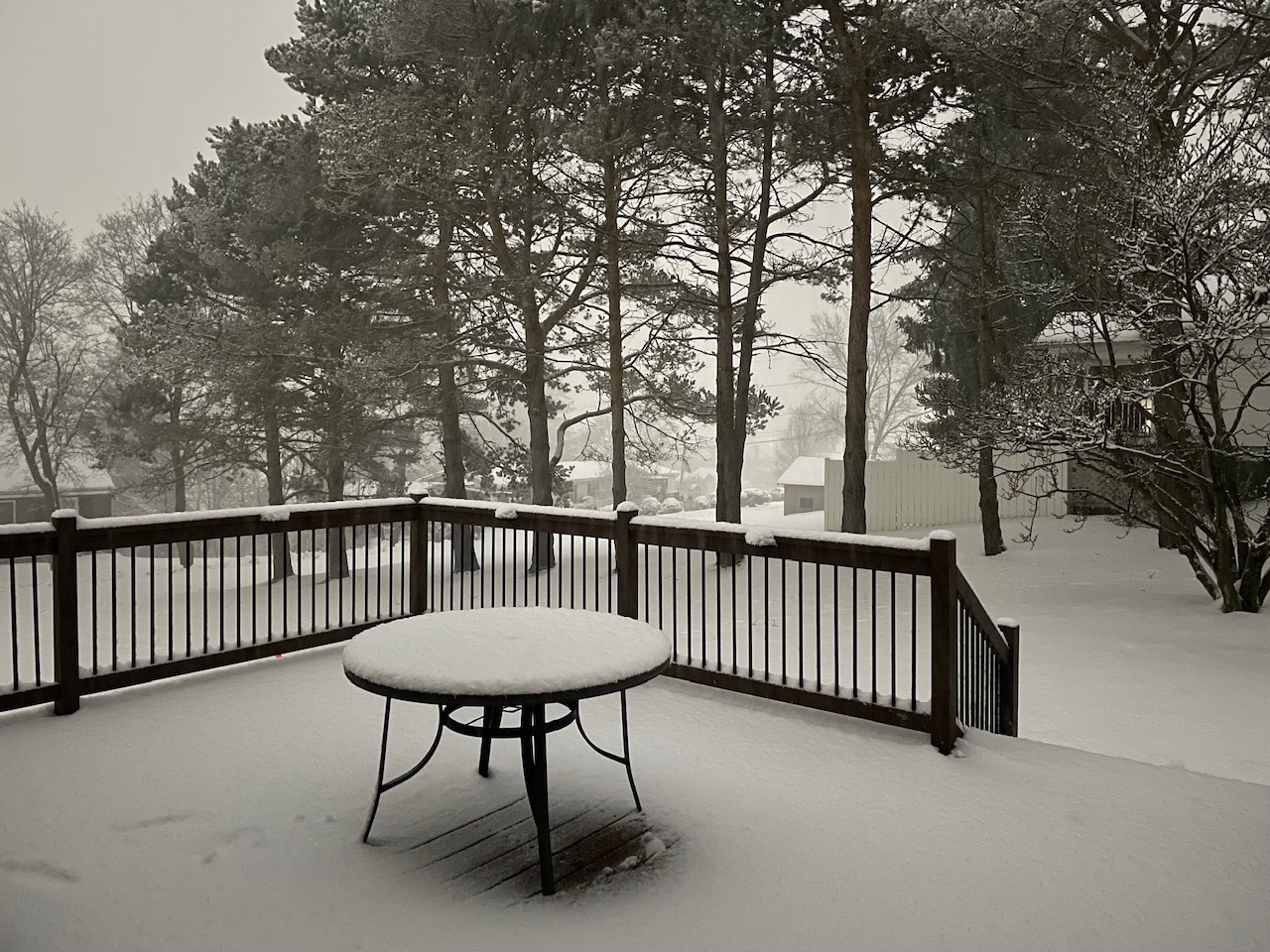
Between 6.5-7” now, heavy rates. 32/32ºF
-
A couple inches were expected even up that way but definitely nothing like this. The Cresson Summit and Gallitzen 511 cameras look nuts right now.
-
This is easily the best snowstorm I’ve ever seen come from a straight cutter. Blue Knob Ski Resort claims a foot has fallen up there this morning.
-
-
At 6”, with heavy snow and 32/32ºF. I think there’s been some compacting too with the marginal temps. This event started around 630am here, what a beat down. Roads have been a mess, haven’t heard too many bad accidents on the scanner but lots of stuck cars.
-
Some of the high res models were showing 10”+ on the top of the Allegheny front just west of here yesterday, which I thought was way over done. But maybe not given how hard it’s been snowing down here.
-
A look at 511pa cams in the Laurels still shows mostly snow on the cams in Somerset Co all the way down to Meyersdale and the cam on the Somerset/Westmoreland line. Mixing or rain on those cams are usually a sign of such things here soon, so probably have some time yet here. I’m at about 5” now so it’s becoming very likely I’m going to verify a warning out of this. It’s funny how all this works after Saturday’s storm haha. I wonder if the high pressure to the north was underestimated, even with the HRRR.
-
The next one doesn’t have much of a high progged to the north like this one actually does. 1035ish N of Maine vs the very deep low approaching. If you guys flipped over to snow I wonder if the rest of the Sus Valley can get a period of snow as the heavier precip moves up into there.
-
Should do cutters like this more often lol.

-
Looks like a full transition back to snow here for the time being. Easterly breeze starting to pick up a little bit.
-
Starting to ping, I’m at 3.8”. Right around 32ºF
-
And the overnight Euro looked rather solid for the 16th. It has a more pronounced and much better placed western ridge… pretty much where you’d want to see it for C-PA. The GFS this morning is getting better too (a little west with the ridge axis). If we’re going to see a legit East Coast snow storm (something perhaps of the KU variety), that’s going to be a feature to watch if we start seeing more solutions like the Euro showed overnight. This is the period where we start to match up teleconnections… PNA to neutral or somewhat positive, NAO/AO/EPO negative, WPO diving negative.
-
I’m at 3” now. I measured 1.3” 30 minutes ago. Big loud flakes falling now.
-
I might need one for this one, lol.
-
Just woke up, and there’s already 1.5” of new snow on the ground and it’s snowing every bit as hard as it was Saturday. Wow.
-
We’ll see, there’s a lot of lead time yet for that system to see where the large scale features end up being positioned. That system should have plenty of cold air to work with, so if it can stay under PA and along the coast there is a better chance for more frozen precip to be favored. But yea, it’s definitely a bummer to mostly waste a really active period this coming week with tomorrow and then likely on Saturday.