MAG5035
-
Posts
6,078 -
Joined
-
Last visited
Content Type
Profiles
Blogs
Forums
American Weather
Media Demo
Store
Gallery
Everything posted by MAG5035
-
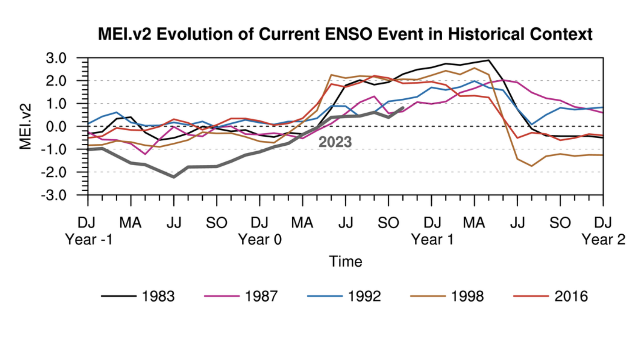
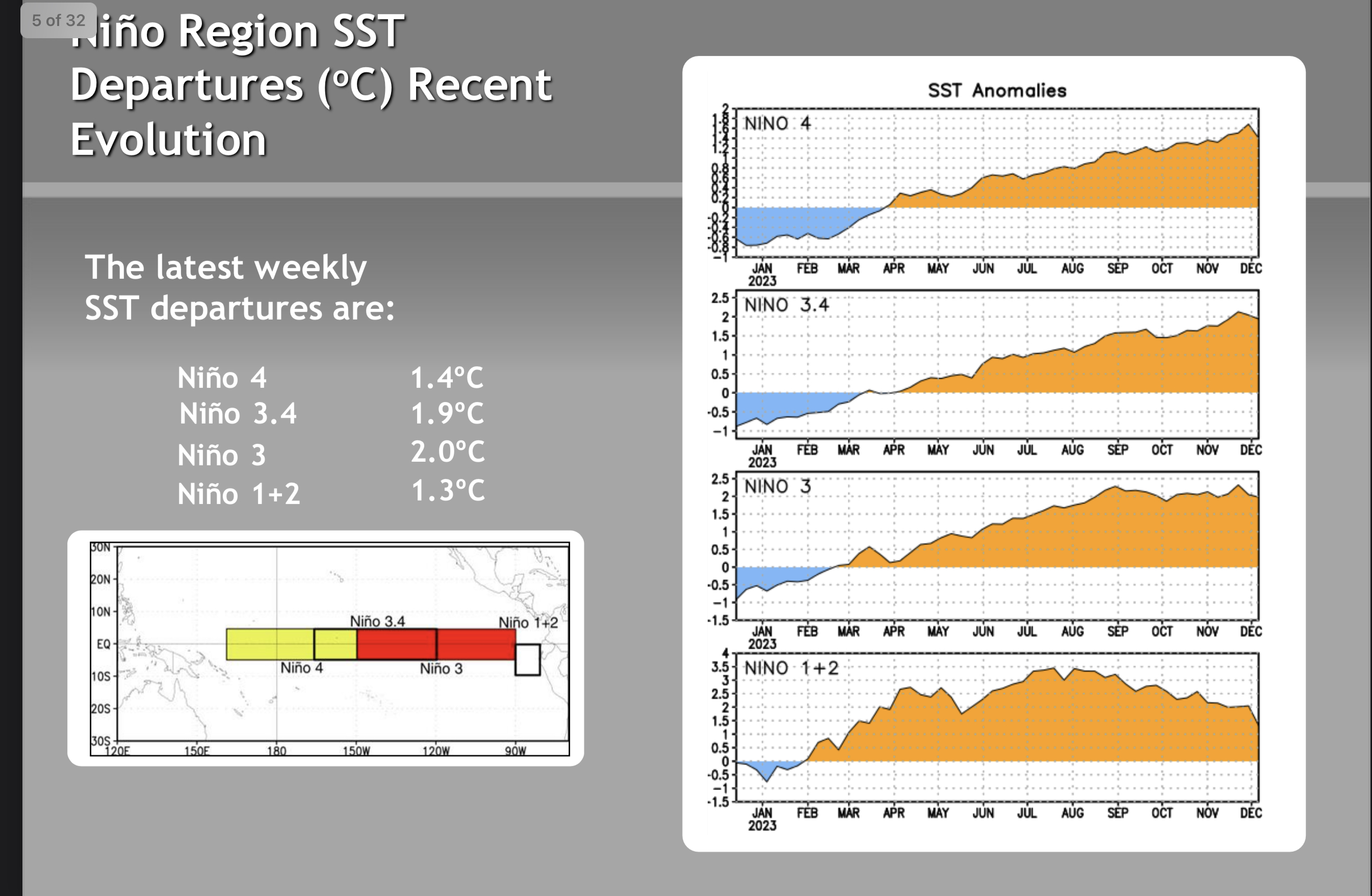
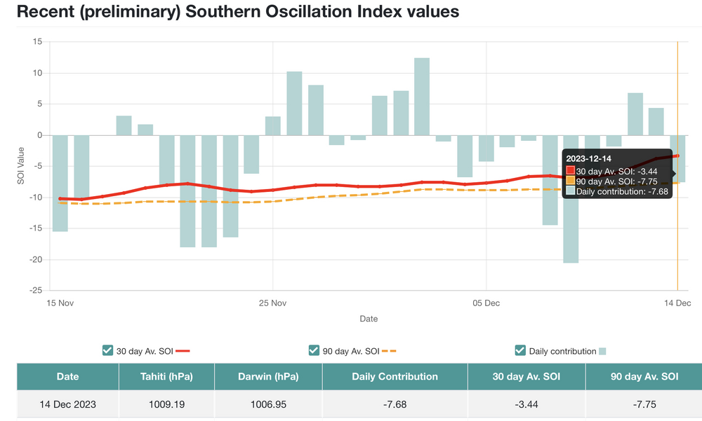
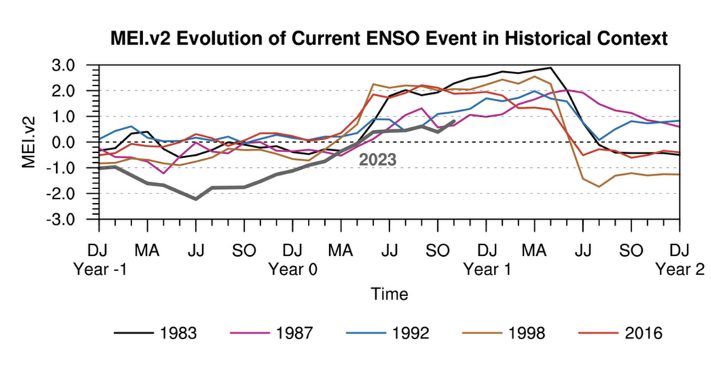
One of the big things he’s been pointing out with regards to the Nino is despite the ocean temp pattern itself indicating easily a strong Nino occurring (+1.9ºC as of 12/11 in Nino 3.4)… indexes like the SOI (southern oscillation index) and MEI (multivariate ENSO index) tell a different story. I don’t fancy myself as an ENSO expert by any means but those indexes are utilized to try to calculate the actual strength of the ENSO event atmospherically. SOI values of -8 and lower are indicative of El Niño conditions being present. The values vary day to day but longer term averages typically reflect the ENSO state. SOURCE According to that, the running 90 day average on that index is only right at the threshold of a Nino, while the 30 day average actually indicates ENSO neutral. So that’s a pretty big disconnect right there. Comparable strength Nino’s generally had significantly more negative values. Here’s the MEI values, compared to some of the other strong Nino episodes. MEI is supposed to be a more accurate representation, as it incorporates 5 different variables vs just one variable with the SOI. MEI Website HERE That index isn’t even close to the biggest Ninos (83, 98, and 16) despite being a strong episode but tracking somewhat closer to the other two stronger ones (86-87 and 91-92) as well as some other winters that had weaker nino’s SST wise. Definitely interesting stuff.. but that doesn’t really clarify whether or not we’ll be snowy unfortunately. Using Harrisburg, 1986-87 had 45.9” ( solidly above average) and 1991-92 had 12.9” (turd winter). We’re still really early into this season and as pointed out previously by many…Nino Decembers are typically warmer than average whether you’re using the good or bad winter analogs. We’re still a ways out in terms of the pattern “showing it’s hand” so to speak on what kind of a Jan and February we’re looking at IMO. I’m just touching on one part of a whole bunch of other factors (NAO/AO, MJO, PNA, stratwarm, Pac pattern in the mid-latitudes EPO/WPO, etc etc). I do like the way things are starting to look going forward, but also am staying mindful that this could definitely go the other way as well. And yes the Nino is forecast to eventually collapse later in the spring next year (and potentially develop back into Nina by next winter) but that’s not a really new development and it’s very likely Nino conditions persist throughout the bulk of this winter. What could occur is the Nino becoming more central/west Pacific based (Aka the Modoki El Niño) which is more supportive of the type of winter weather we’re looking for than an east based Nino. And we’ve already been seeing the waters cooling in the tropical eastern Pac (Nino 1+2). Off the ENSO Update issued Mon 12/11

-
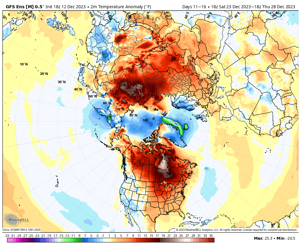
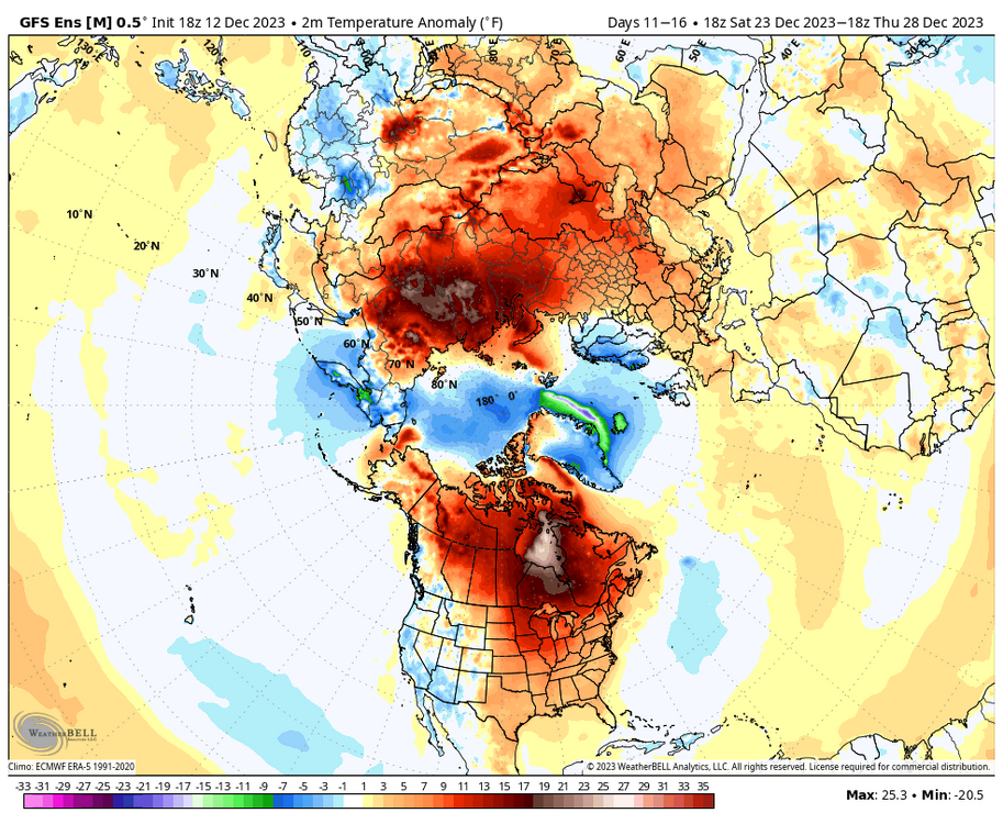
The problem with it I see is the connected low heights all the way to the Pacific, indicative of the WPO that has been and continues to be forecast persistently positive and the EPO after the dip next week around the timeframe of the coastal is forecast to trend back positive the rest of the forecast period. That kind of alignment implies a pretty good dose of Pac origin to our airmass, despite the development of the below average 500mb heights across a sizeable chunk of the CONUS. Yea that’s good for potential undercutting southern stream systems that track under us, but look at the 18z GFS result for the 17th-20th coastal. Looking at a 2-3+” rainstorm in all of PA despite the phasing with northern stream energy and an ideal coastal track via that particular solution. The problem is across the board on model guidance though with that, the cold just isn’t there for it.. not even close. We need to build an actual western US/ Eastern Pac ridge, that would at the least source Canadian air (even though temps are significantly above average for there) to go with the undercutting low heights. Here was the last 5 day (D11-16) avg temp anomalies from that 18z GEFS. By the way, I am not part of the winter’s already over or is going to suck crew. It’s been noted that a lot of forecasters and Nino analogs, even the cold ones featured a warmer than average December over a lot of the US. Even JB said it was going to be warm first half of the month, just that he thought that this was going to turn around the holidays. Which it may, but right now I don’t see a quick enough wholesale turnaround in the pattern for that timeframe (at least by Christmas).
-
Temps in our neck of the woods have been averaging normal-ish on ensembles thru the 10-15 day period. It doesn’t look all out torchy, but the true big + anomalies are at higher latitudes like the north-central US and most of Canada. Clear indication that anomalous arctic cold is out of the equation on our side of the NHEM for now (it’s over on the Asian side). AO/NAO have been forecast to be increasingly more positive during this next 10-15 day range and ensemble guidance, esp the Euro EPS really show low heights over the poles and high heights over the mid-latitudes. EPO is forecast to take a dip negative which could help draw a source region from Canada, but there’s no “cold” there.. so what comes down only would be seasonal for us and not below average until say the southeast US. We’ve also been traversing phase 4-5 the last several days in the MJO, which is forecast to be heading in the null phase the next couple days. That jives fairly well with our recent period of being above average temp wise. To sum all that up, we’re not there currently for sustained cold and snowy.. or even really stormy at all for that matter. The main weather feature to keep an eye on during the whole forecast period for op guidance is the potential southern stream system thats been modeled around the 16-18th. Most guidance has had a fairly potent, slow moving coastal system near or up the coast… the problem of course being there’s a lack of cold air for it. This could eventually come back to being an interior/elevational threat for snow as guidance is able to hone in on it more (obviously dependent on track) but I don’t think there’s going to be enough cold around for places like the LSV and Mid-Atlantic with that particular system.
-
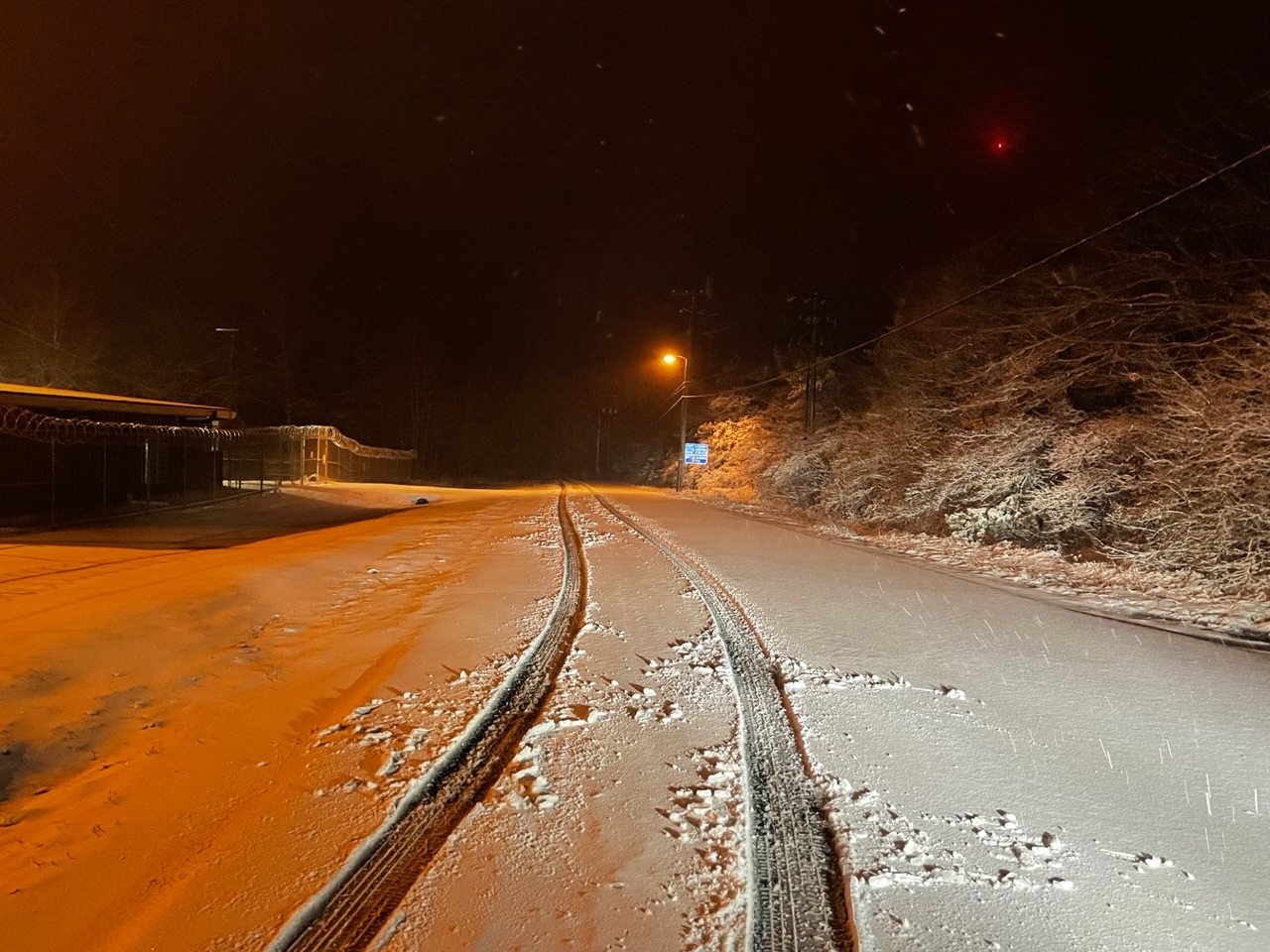
Light coating on the grass here at home. Looks like I’ve succumbed to the back edge though so that may be it for me until the NW flow stuff starts setting up overnight and early tomorrow. Took the 5 mile drive up to the top of Wopsy and there’s a couple inches pasted to everything up there. About put the Subaru in the ditch (Blizzaks aren’t on yet) to bring the goods haha. Road went from snowcovered over wet pavement to snowcovered over frozen near the top.

-
To add, when I was outside it looked like snow is starting to mix in here in Altoona. Not home currently, but weather station at home is down to 35.
-
511 cams in the Laurels (US 219/22/30) showing the accumulating snow is underway up there.
-
It’s been a pretty rough run of it in the NYC metro. I believe they’re up to 665ish days since Central Park has recorded at least an inch of snow, which is far and away an all time record of futility there. Speaking of such records, this ought to throw some gasoline on the great MDT T debate haha. Saw this noted in CTP disco yesterday. There’s a half decent chance they’re probably not going to get to pass #2 though.. unless the Monday ob is taken on the tarmac behind a jet warming up for takeoff.
-
Timing/evolution for the precip changeover of tomorrow/Monday’s system continues to be a bit intriguing . I still think the Laurel’s/central have the best chance of seeing accumulating snows overnight Sunday after the transition. Further east into the Sus Valley I’m not as sure. I think everyone will see a transition before the precip ends but whether it’s something meaningful is the big question. We’ve all seen the overmodeled snow totals not come to fruition in the Sus Valley from similar set ups to this many times. One disadvantage I see is the cold air mass coming behind the front is certainly cold enough, but not impressively so. Surface temps look to be a bit of an issue that would likely mean a snow event that is a good bit less than 10:1.. especially in lower elevations. On the other hand, one advantage this system looks to have is dynamics, as it’s a pretty feisty shortwave having already caused (and is causing currently ) severe issues in the Ohio Valley and Deep South. We get a negatively tilted orientation of the trough as we develop a coastal low that runs up the frontal boundary. High res guidance like the NAM deepen the low pretty significantly as it comes up the Mid-Atlantic coastline. The dynamic nature of the system is why I think we get the changeover to carry across from the central counties to the LSV but accums are going to have to come from heavy rates with the marginal surface temps. Short range stuff like the HRRR starting to get into more decent range take accumulating snows into the Sus Valley fairly easily and the 18z NAM took it all the way inside I-95 from DC to NYC. The short term high res guidance also seem to have a bit of a lull in precip, shutting off in the central and lightening in the east for a few hours in the late afternoon/early evening. Rates then ramp up as precip shield redevelops and enhances with the deepening coastal low and that’s when the transistion starts to push east. Positioning of the frontal boundary coupled with the timing of the coastal running up it is going to be key for setting up the corridor of the best potential for accumulating snows.
-
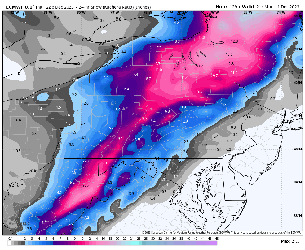
Kuchera indicates the event is <10:1 in PA east of the Alleghenies ( central counties and LSV), a probable outcome given the changover scenario the Euro presents. A rapid temp drop in the column post front that allows a quick change to snow BUT the best precip ends before much colder air aloft arrives that would boost snow growth/ratios. Surface temps also fall from the 50s to near or just below freezing during the event (marginal but sufficient to accumulate with higher precip rates).
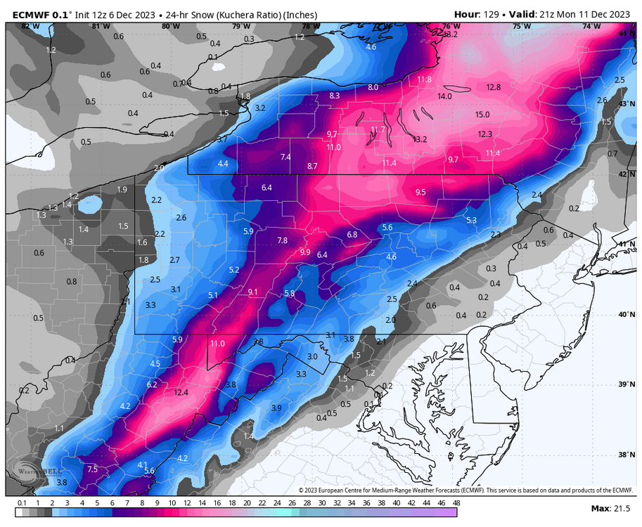
-
Euro is definitely much more pronounced with the vigorous shortwave and deeper with the surface low that runs the frontal boundary and enhances the the precipitation shield in C-PA post frontal passage. Modeling has been pretty persistent on some kind of an attempted changeover across at least some of PA the last several runs having this system with a sharp cold frontal passage. I think this scenario probably favors laurels and central counties more but the Euro solution does show how it could snow for most in here. The low develops along the boundary in VA and moves into central NJ (996mb at that point). GFS is trying to do the same thing but just isn’t as amplified as the Euro. Definitely intriguing, the range for this system isn’t really super far out (~D5).
-
Some occasional flurries/light snow here as well. PBZ radar indicates a wave of steadier snow that looks to get into the Laurels and perhaps some of the central counties as the afternoon wears on.
-
There’s definitely an opportunity to be had for the system progged near mid week next week. Coming on the heels of the stronger Sun/Mon system that resets the cold for a few days and a pretty decent -NAO block, there’s a good chance this northern branch feature is forced to track it’s low below PA.. which is a good start to getting any kind of meaningful flakes beyond western PA and the Laurels into the Sus Valley when it comes to clippers/clipper-like systems. Most modeling and ensembles have this feature, so strength and track of the feature are going to be the big thing. Today’s 12z GFS version is definitely more ideal, having a more defined and stronger surface low that tracks under PA which yields a better snow swath. A weaker feature going south of PA would still have some of the same issues with precip surviving east of the Alleghenies. A stronger one like the 12z GFS would establish some Atlantic fetch with the low hitting the coast, maintaining a swath into the Sus Valley and/or points south of there.
-
I’m not home currently but clearly the first measurable fell at the house this morning.

-
I probably slept through any pingers that may have fallen first thing this morning, but I may not have gotten any at all. Temp briefly was around freezing before midnight and hovered there til about 2am when a pretty good southerly breeze mixed down and kept temps in the mid 30s through precip arrival with no drop. Still a raw 35ºF with moderate rain. Wind shift and temp change highlighted (approx 140am) So now the race is on to see how big of a much needed rain event we get today. Most modeling has things in the 1.5-2” range in Central/Sus Valley for this event today/tonight.
-
Advisories were issued earlier this morning in the Laurels counties for mix/glaze of freezing rain (up to a tenth ice in the adjacent western MD counties). A larger portion of C-PA (likely the AOO-UNV-IPT corridor into NE PA) probably sees an initial period of wintry mix when the main precip arrives tomorrow morning given a pretty strong, though retreating high pressure over New England providing a CAD setup. High res guidance like the HRRR and that newer Rapid Refresh (RRFS) are more robust in cooling the 850mb layer on precip arrival and showing more frozen p-type (sleet and even snow). 3k NAM does show a bit of the same with regards to 850mb but shows freezing rain as a more dominant mix type. Reality is probably somewhere in between, with a better chance of a longer period of frozen the further north into PA one goes and biggest ZR impacts on the Laurel’s ridges and some of the adjacent ridges in the middle of the state. Could be interesting to see if advisories end up being warranted a bit further into the central counties. As noted by CTP, surface and road temps are likely to be quite marginal for impacts. A period of heavier mixed (esp sleet) could change that a bit.
-
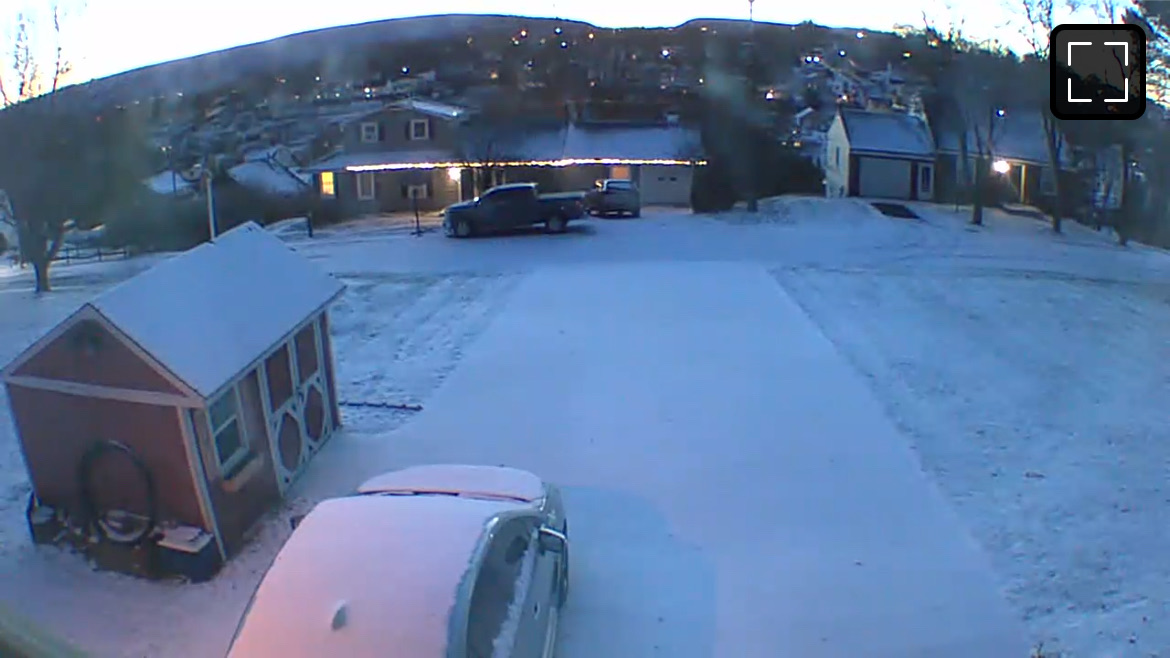
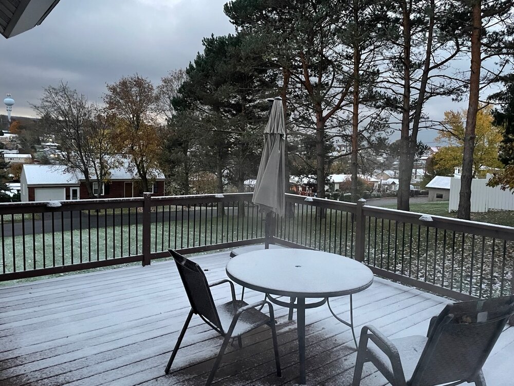
Same down here. A bit more on the roofs, decks, car tops, etc than the grass which has a light dusting. First deck pic of the season haha
-
It’s been awhile since I’ve gotten a post on here… summer and fall are usually pretty busy for me. But I’ll be getting back to posting more regularly again. Certainly can’t miss possibly having some first flakes to observe overnight. Been watching the band of precip in western PA getting closer. It’s mostly clear currently and temp/dewpoint has fallen back to 32/29ºF.
-
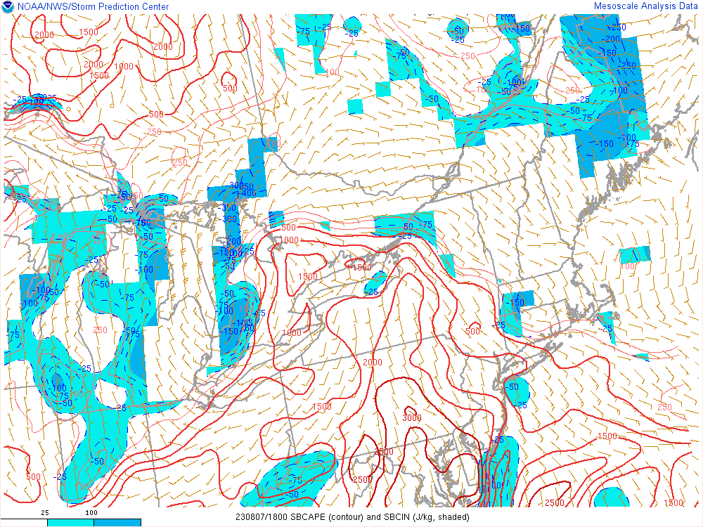
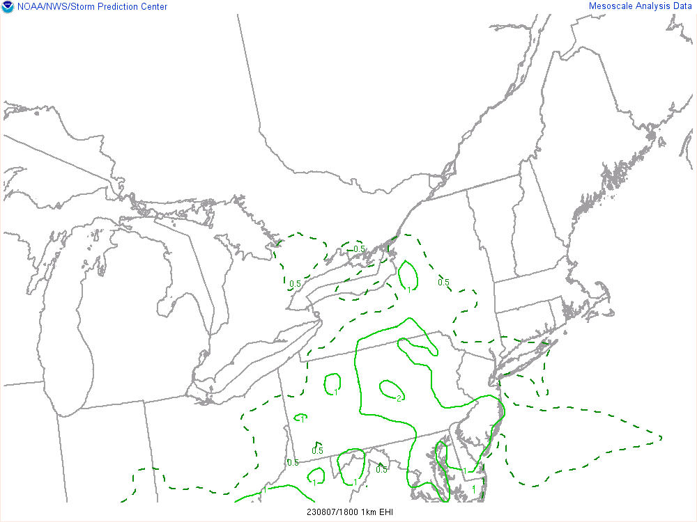
Good bit of discrete cellular stuff firing from the ridge and valley eastward in the corridor of PA where the sun really came out this afternoon. Parameters (bulk shear/BRN) are very favorable for such things in all of C-PA today. Helicity values aren’t super noteworthy but they aren’t zero either, and that coupled with the best CAPEs being right up the whole Sus Valley currently means an area of 1-2 EHI values. Spin-ups are definitely possible just about anywhere. Tornado warnings now in northern Lycoming with a pair of decent looking couplets on BGM radar. The cell previously responsible for the tor warning in State College still looks pretty strong as it heads toward Sunbury. Everything severe is on the table today (esp severe wind) but I think the tornado/hail threat probably maximizes with the discrete stuff developing up front. This likely switches to a more clustered and/or linear type deal as we get into the late afternoon/ early evening and all those storms traversing WV/western MD and the Pa southern tier push into the Sus Valley. Of particular note there is the solidifying line from Bedford/Fulton south into MD/WV.
-
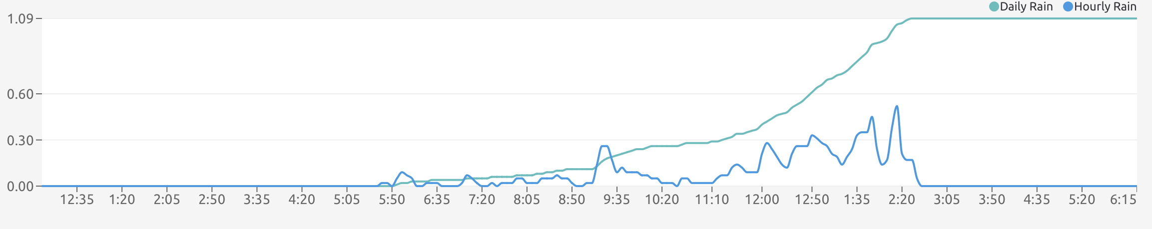
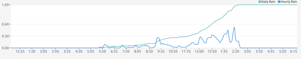
1.09” of much need rain here today, it’s a start.
-
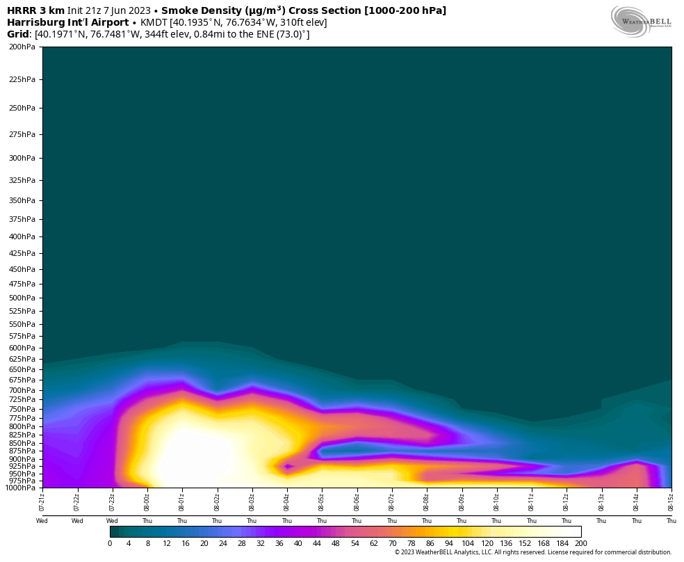
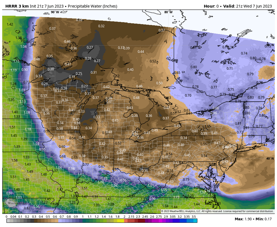
After doing a rare June perusing of the models and discovering that there is an HRRR cross section smoke forecast, MDT looks to see a rapid deterioration within the next hour or so according to that (or perhaps right now-ish per JNS’s ob), which is supported by the general motion observed on the visible satellite imagery. Also want to note in the previous post the station obs plots in the satellite imagery. Another really anomalous part of this setup aside from the severity of the Canadian wildfires themselves is the major North American blocking pattern that is directly discharging Canadian air via due northerly flow.. which is why we’re in the crosshairs of all this smoke in the first place. Dew points are in the low to mid 30s across the commonwealth, occasionally even in the upper 20s at some PA sites this afternoon… something CTP noted last night in their disco as practically unheard of for June around here. PWAT map is another example of how dry the airmass is.

-
NE PA/NJ/NYC/LI is definitely where the worst of the smoke is currently, as evidenced by the visible satellite as well as the AQI maps.
-
The closest cell around here earlier this afternoon that mainly moved through Cambria County delivered some rain drops but not enough to register measurable on the rain gauge. Last measurable was May 20 (0.17”) and total last 30 days is 0.7”.
-
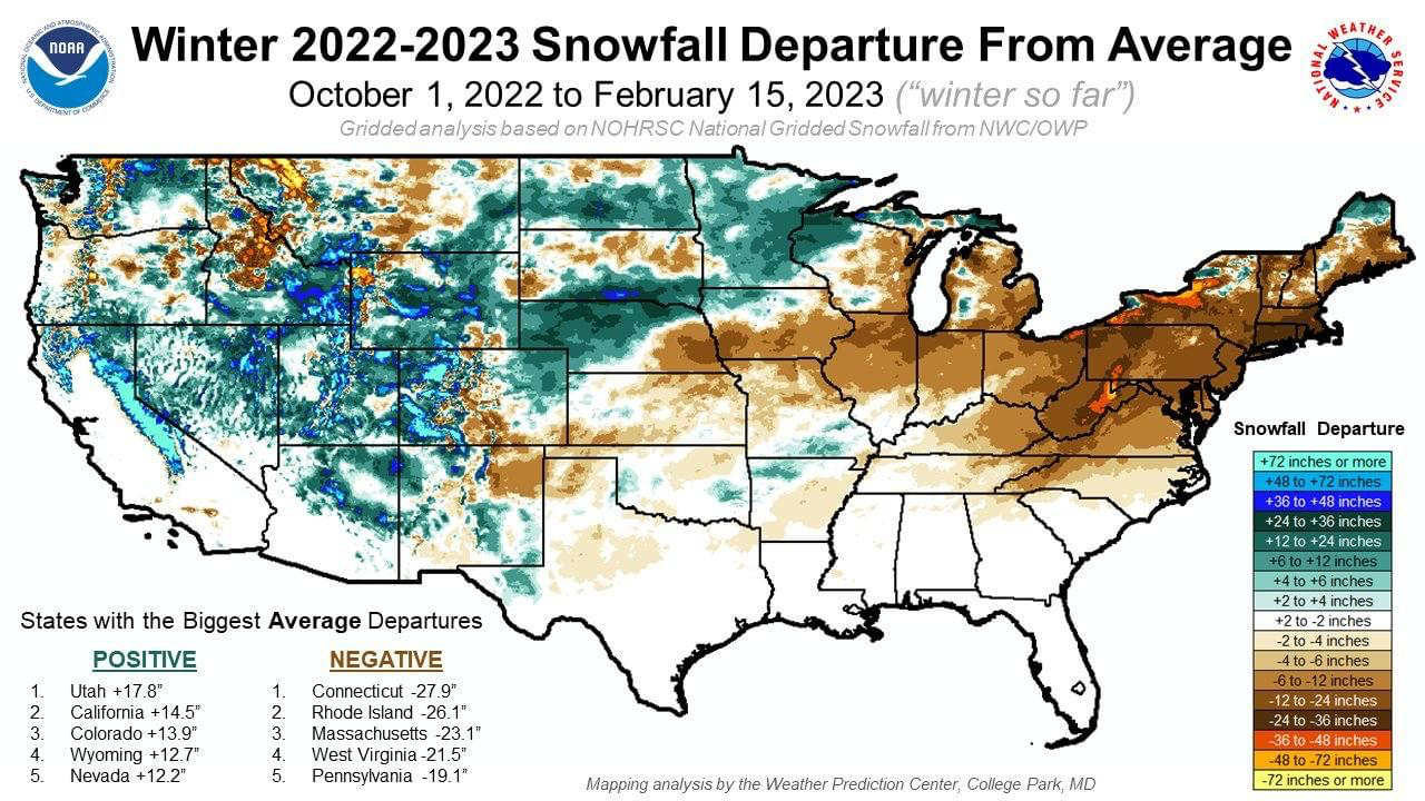
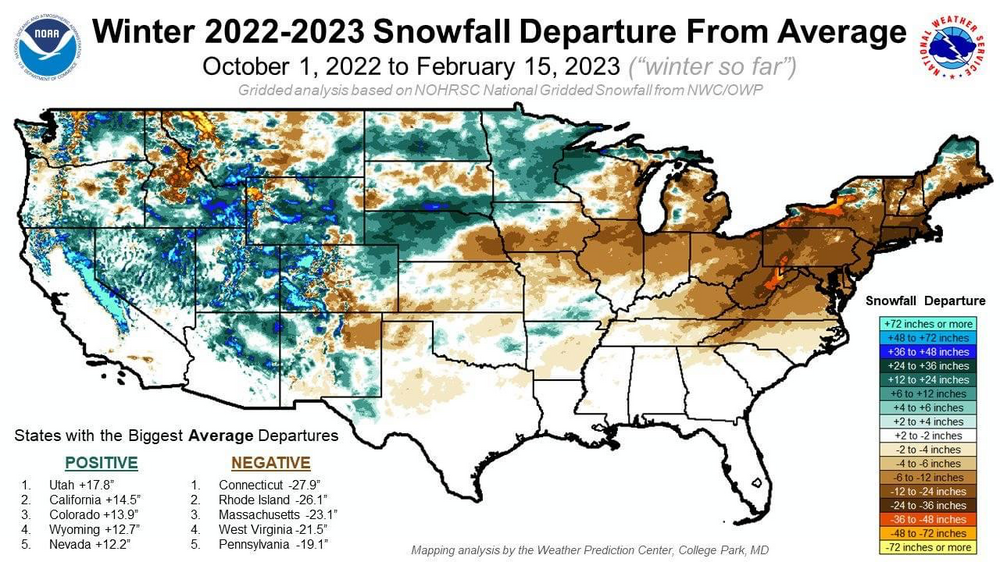
The near 4800’ peak just south of Canaan Valley State Park, WV (aka Mount Porte Crayon) doing it’s best Mammoth Mountain impression on the zones. This is the kind of setup (prolonged post storm cyclonic flow upslope event) that has been missing quite often for what seems like the last 5+ winters and is a prime driver in those snow departure maps that were shared around during the winter such as this one below showing one of the biggest departures anywhere in the eastern US (inch wise and also percentage of average) in these very areas. This setup occurring in the middle of winter would have likely yielded a long duration 1-2’ type upslope event just in the Laurel’s at their elevations. I know one of these maps were floating around that incorporated the last few winters back to 19/20 but it’s the same general theme for the Laurel’s/Alleghenies. These type of upslope events via this setup are a major part of what gets the higher elevations and ski resorts of that region their high snow averages (>150”).
-
Already acquired the 5/1 T for the day, just got blasted by a graupel shower that took the temp all the way down to 40ºF. Because April heat brings May sleet, or something like that. What a bipolar spring.
-
0.73” for the day and 1.47” since Friday are my totals. Other noteworthy ob was my station was down as low as 990mb earlier. Def a pretty impressive coastal low.