MAG5035
-
Posts
6,078 -
Joined
-
Last visited
Content Type
Profiles
Blogs
Forums
American Weather
Media Demo
Store
Gallery
Everything posted by MAG5035
-
To further on what Anthonyweather shared a couple posts above from DT about the miller A vs miller B scenario, the Miller B scenario in this case would have been best for a longer duration system and more of a broad shield of precip across PA. The A solution that most guidance has settled upon shortens the duration and tightens the band of best QPF up since the system itself isn’t progged to be overly strong anymore. So the folks that see some of the best amounts are probably gonna be living dangerously in terms of the proximity to that changeover line.
-
While the NAM itself seems completely disinterested in making any kind of event at all in PA, the SREF blend looks surprisingly reasonable. It generally sits in between the Euro EPS and the lackluster GEFS blend. I think the NAM eventually picks up on it the next few runs. There’s too much support for an event across the board to reasonably think otherwise at this point.

-
Could be a couple of things. I won’t put words in anyone’s mouth but here’s my objective thoughts on some of the cons of this setup. Precip issues are still possible in the southern tier even with these lower QPF/progressive solutions depending on the thermals.. something we won’t have a firm handle of till we’re in range of the high res guidance. I do think we’ll see mostly snow in here from this, but the possibility of some mixing in the southern tier still exists. We’ve changed the pattern around to where it’s cold enough and we have a high available for this system, but it’s still not significantly cold here.. just cold that’s average. The 500mb pattern out west is not typically what you would see for a C-PA snowstorm. We’re always looking for the big western ridge and associated amplification to run a coastal storm all the way up the coast and we have the complete opposite with the -PNA setting up and a big western trough. What makes this work is having some downstream blocking and 50/50 low allowing this shortwave that kicks out from the southwest go underneath us. What’s being pointed out by some is these weaker solutions late today along with being faster come from more energy dumping into the southwestern trough (which eventually becomes our next headache next week) making for a weaker shortwave (that becomes our weekend storm) that kicks out. That kind of evolution takes away the top end potential. This is still probably a half decent event but not a blockbuster 1-2 foot type thing. More of 4-8” kind of event is what I’m thinking right now for the swath of heaviest snow… which I think about anyone in here would be happy with.
-
Speaking of keeping expectations in check, lol. I’d make a sizable bet stuff like this is what he’s referring to. I just took that screenshot so 5hrs ago was after the 12z suite today.
-
18z Euro EPS vs 12z, still okay but means are down a bit.
-
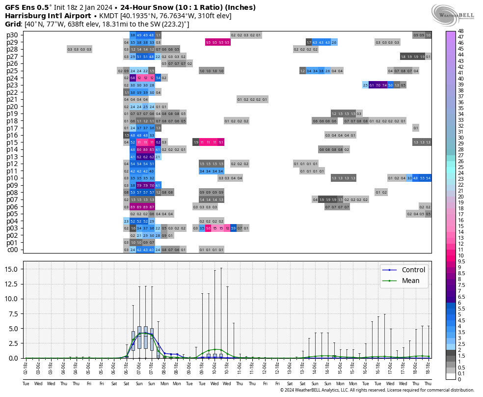
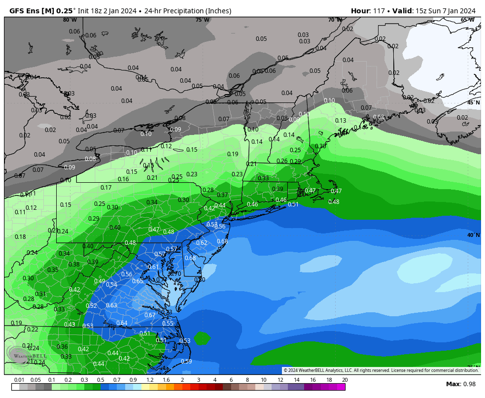
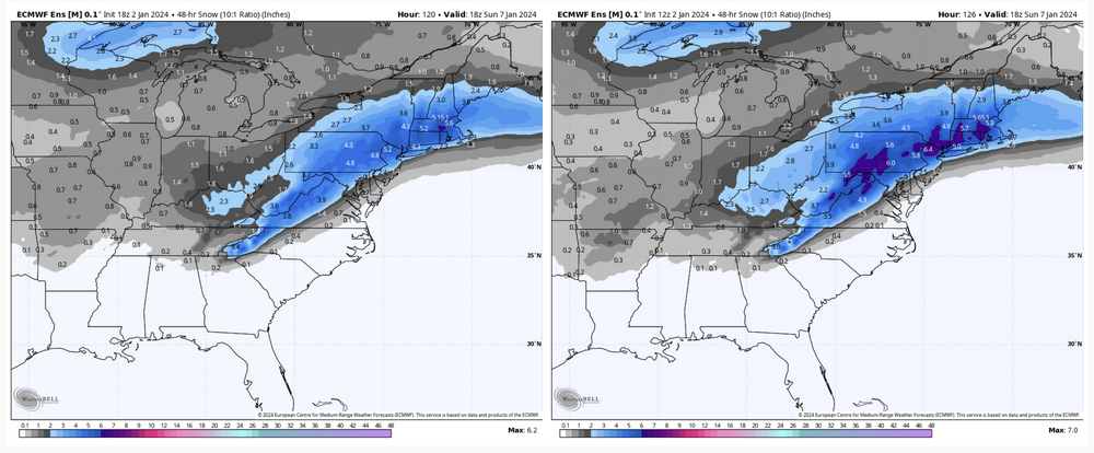
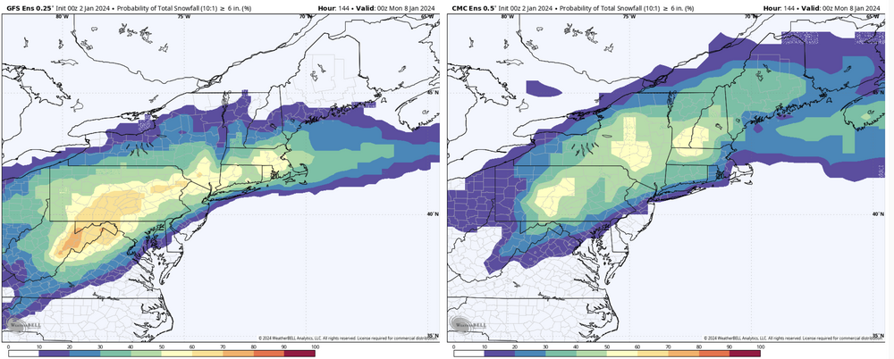
18z GEFS mean still involved most of PA but was def lean on QPF. Total QPF mean Let’s have a look more specifically. Here’s MDT’s 24hr snowfall on the individual members. The majority show at least advisory snowfall, while only about 1/3 crack warning criteria (5”). And there’s about 8 members that would be sub-advisory type snowfall. This was a really progressive run on the GFS/GEFS this go around. Is it right? I dunno.. Usually Gulf lows find a way to have a nice precip shield with it and I think this might have went a bit far on the dry side. The more progressive/less QPF trend was noted just about everything today though. This thing is just starting to come onshore on the west coast, so the next few runs will be interesting to see.

-
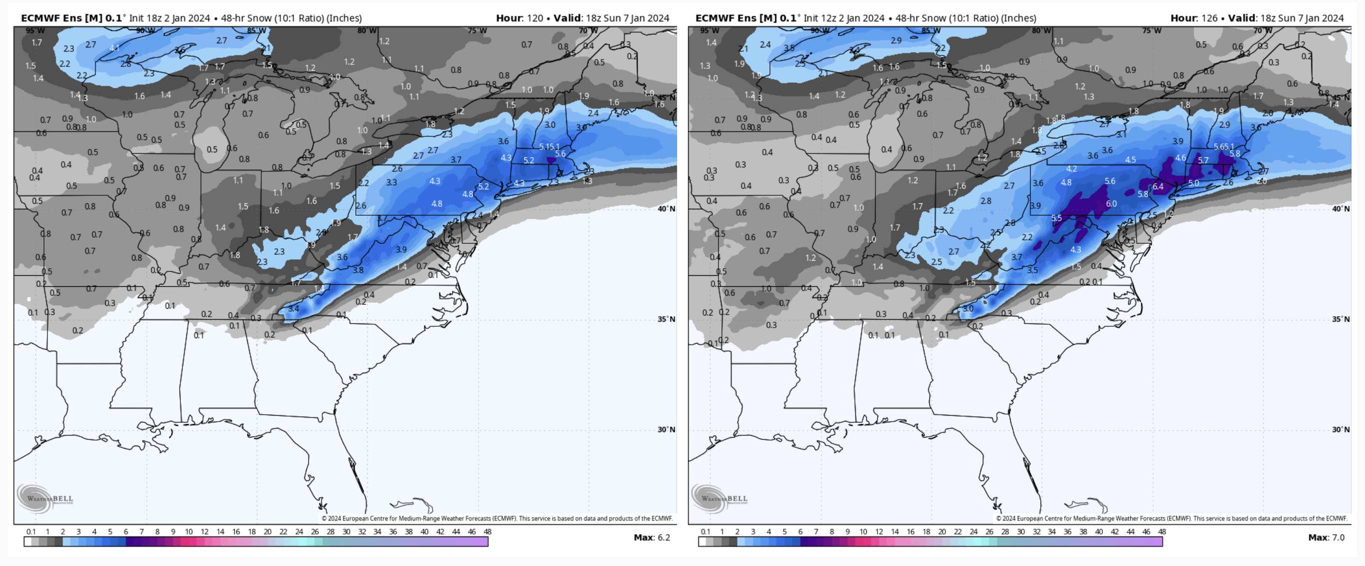
To further on the 12z Euro EPS 3”+ probs 6+ probs Edit to note that the 12”+ probs are completely non-existent (no ensemble member showing 12+), so the ensemble overall has definitely picked up on the faster motion of this storm.
-
The biggest difference in the Euro 12z vs 0z is by far the total QPF. A difference of 0.5”+ (less) in the Sus Valley.
-
We’ll see haha. This system has been trending a bit faster both in onset time (mid-late afternoon Sat) and certainly in duration as it’s looking more like a 10-12hr event now. So I think if there’s an area of double digit amounts to be had with this, it’s likely going to be from getting >10-1 ratios. C-PA should see the best zone of 700mb lift and temps at that level for the event over the subforum are generally -6 to -8ºC. Those are okay numbers but not in the ideal range for the best snow crystal growth. There’s sufficient cold for the snowstorm but not for a high ratio event (like another 1/7 storm from way back). So I think 12-13 to 1 is probably the high end for ratios, which is only average for a snow event this time of the year in C-PA. These Gulf storms usually have the smaller flakes that make for a dense snowpack as well.
-
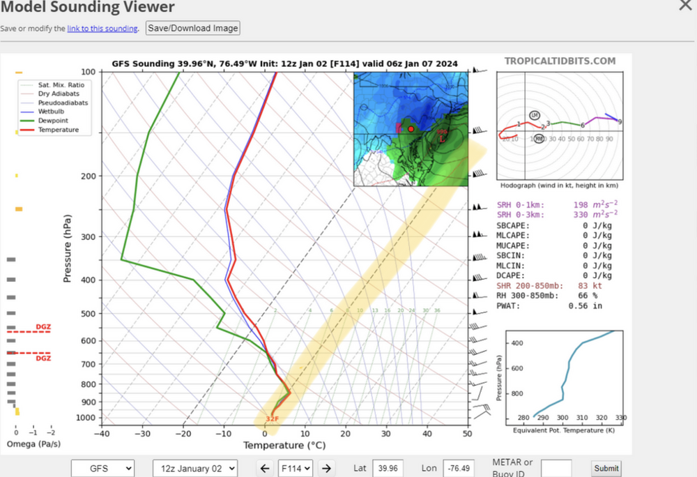
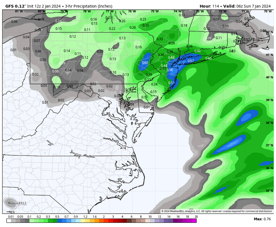
Yea, that’s an isothermal layer from surface to about 850 thats essentially between the 32-33ºF range (highlighted for you). Light rates might be drizzle/freezing drizzle depending on surface temp, but moderate to heavy rates would likely be snow with that kind of skew T presentation. Here’s the 3-hr precip from 111-114. A couple tenths fall in parts of Lancaster in that timeframe, but the rest of LSV west of there is mostly done at that point. That’s the furthest north I’ve seen the GFS take the primary with its Miller B solutions. The low’s weak and the transfer is already occurring so it still kept most to all of the state snow but the other part of that equation is the best overall QPF in the frozen precip zone went deeper into central PA. Though I suppose there’s not a huge difference since everyone in here generally gets in that .75-1.00” range. Obviously one model run and a global model at that, but we are getting into the range we can start scrutinizing the details on these runs more. The high res stuff when we get to that range (NAM, HRRR, et al) is where we’re going to really hone on the thermals.
-
Weatherbell really didn’t send a changeover across the Mason-Dixon Line. I know the algorithm gets a rap for being snowy or whatever but that particular map is a 6hr frame and if you use a 3hr frame bulk of QPF is thru York/Lancaster by 111hr. Thermals at 850/925mb/surface are still fine at that point. At the 114 hr frame the 850mb 0 line is shaped pretty much like the changeover line on that TT map but the 850 temps are still within tenths of a degree of zero in that little rain area that intrudes into PA as are 925 and surface. So if there’s any heavier precip left between that 111-114hr frame there it’s probably going to be snow… albeit likely at reduced ratios.
-
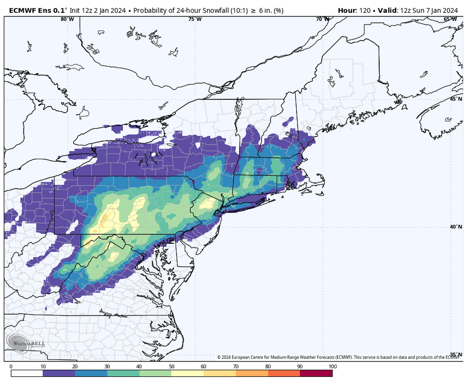
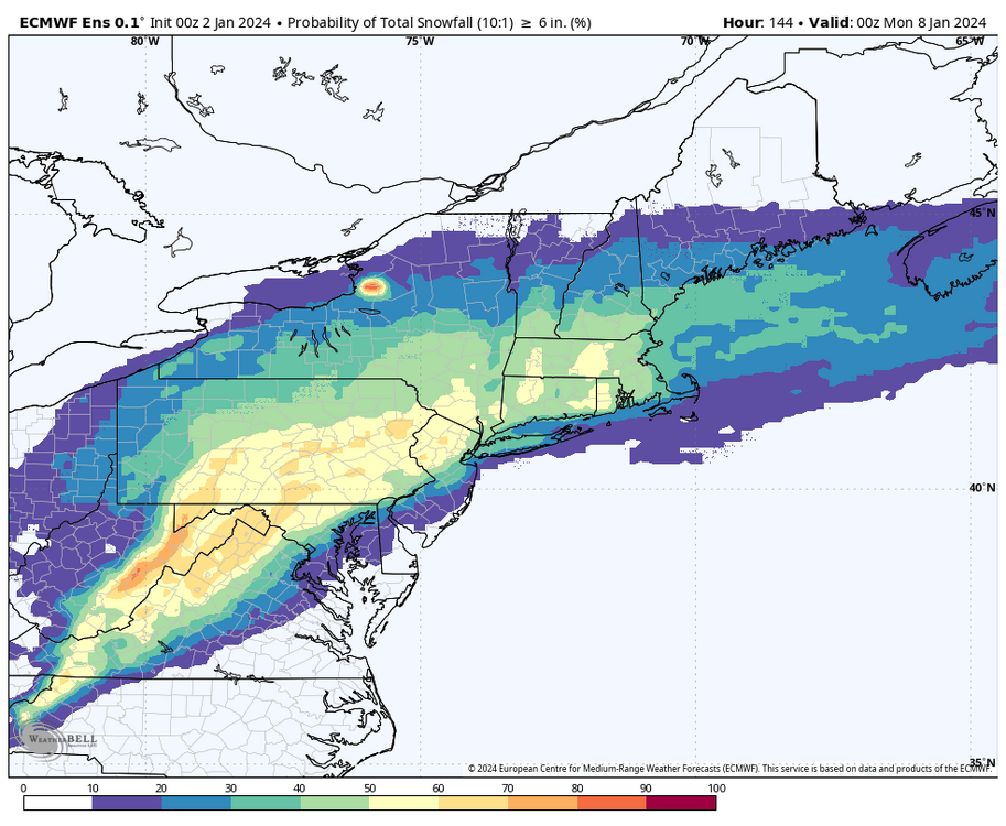
0z ensembles for 6”+ probabilities. Euro up top with GEFS v. Canadian ensemble comparison underneath.
-
0z Euro right in the zone for C-PA snowstorms (Low on the Delmarva coast). Figured I’d contribute a little bit to the pbp haha. The 0z suite as a whole is definitely solid tonight.


-
Well the run to run consistency was fun while it lasted lol
-
Snow of varying rates has been occurring here throughout the evening, with about a half inch of wet snow on the deck and grassy surfaces. Temps hovering just above 32ºF (32.5ºF currently). Going by the tenth, my weather station still actually hasn’t gotten down to the freezing mark at any point since overnight Dec 23rd.
-
Same here with a coating. Got a nice burst of snow going right now too. Pittsburgh radar showing what should be another wave coming through later on this evening.
-
I’m sure we’re all aware of the risks here at this lead time. My concern is of course, the relentless creep northward of the changeover line as we get to closer lead times. The good thing is we have the features we need in terms of a 50/50 low (with some Greenland blocking to hold it) and a surface high with cold air that is available. This is a really short wavelength pattern in the CONUS with the big trough already dumping into the west as the 1/7 system is approaching… so I feel that actually should help in this instance in combo with the aforementioned downstream features as heights won’t be able to build ahead and allow the storm to fully cut. The storm that’s been immediately following in the progs next week is a different story but that’s a bridge to cross on a later day. Evolution on guidance has been trending towards the miller B solution, so how far the primary drives is going to be the key there. With what I see currently, I think the transfer should happen underneath us… with the possibility of our southern tier getting into some mixing issues at some point in the event. That doesn’t have to happen though, we have the potential for an all or mostly snow event for the subforum here.
-
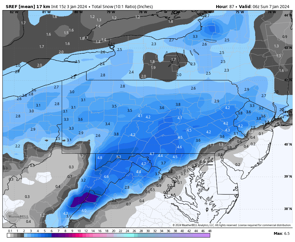
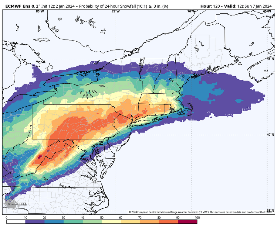
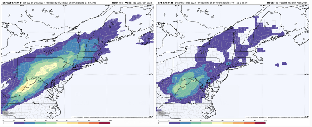
0z Ensemble probs on the 6-7th storm for >3” 24hr snowfall. Euro EPS vs GEFS. Canadian ensemble mean looked more similar to the Euro swath… which is a pretty solid signal at D7. I’d say we officially got something trackable. The system on the 4th-5th is still in play too, via the northern stream since the southern feature mostly stays separate. There may be just enough amp of the northern stream feature to generate an area of light snowfall over the area (something kind of like the 0z GFS).
-
While CTP isn’t showing too much in their winter products at the moment, you might be in line for some snow New Years Day along with the Laurels as a shortwave drops through from the lakes. That might bring in a period of steady snow that could put down an Inch or so west and NW of KAOO-KUNV and what might end up being advisory worthy numbers in the favored upslope areas of Cambria/Somerset. There’s also likely to be a period of snow showers tomorrow in the western half of PA.
-
Decided to pull this back up, my last pattern related post 9 days ago back on the 19th. So this has generally been on target I suppose… and I continue to think any big time cold happens mid Jan on. What happens in the meantime is up for debate. It’s looking more like the same type temperature pattern over the CONUS and Canada into the first week of Jan with significantly above normal temps in Canada and northern US and average to below the further south in the US you go. Our neck of the woods looks seasonable to somewhat above, but likely cold enough that a reasonably tracked storm opportunity might be doable. That timeframe seems to be in the Jan 4-6th realm. Ensemble guidance has been roughly suggesting it and the new 12z Euro op just about pulled it off. There’s been really poor run to run consistency with op guidance.. especially with the GFS. There’s big differences in the mid-range to D10 between the GFS and Euro just on this current 12z cycle, with the Euro being much colder. At any rate, here’s my concerns about the pattern getting into week 2 (second week of Jan). The pattern is certainly changing heading into this period. The big thing is the significant warm anomalies in Canada disappear and are replaced with cold anomalies. So that’s a good first step. Teleconnection wise, ensemble guidance has been developing Greenland blocking and injecting actual cold into the CONUS. All ensembles show solid -NAO/AO. Here’s the issue I’m seeing… The PNA which has been pretty positive as of late reverses to negative around that Jan 4-6 timeframe. The EPO goes into a positive spike, specifically on the GEFS…but in that same timeframe. The magnitude difference could be why the GFS/GEFS has looked a good bit warmer in the east… along with much less high heights over Greenland. But either way, the main three ensembles show the flip to negative PNA. My main concern with this is that the cold that’s finally on the table focuses.. at least initially.. in the west and central. That can still be a good thing if we have the solid -NAO since that would probably keep us near the storm track while having sufficient cold available. It could also suck if it’s more of a GEFS evolution (less Greenland blocking and -NAO) where the mean trough axis is too far west popping up heights off the east coast (making us prone to cutters). I do think if the latter scenario happened that the cold air still eventually comes, but delayed (again). 12z Euro EPS v GEFS 500mb (5 day avg D5-10 anomalies). Note the much more pronounced + heights over Greenland on the Euro Euro EPS v GEFS temps ( 5 day avg D10-15)
-
Yes and no. Doing 10/11 to 19/20 Philly averaged about 24” a season to UNV’s 34ish. 24” is about PHL’s 30 year avg and 34 is about 10” less than UNV’s 30 year avg. So if you were going off of departure from the station’s average, then yea PHL had a better decade. I’m sure the average deviates some whatever you consider for the 2010 decade. If you went for the true decade you’d be splitting winters (starting Jan ‘10 and ending Dec ‘20). The big takeaway though is that PHL outright outsnowed UNV on what would be considered the snowiest winters of that decade.. and I’ll throw 2009-2010 in there. 2009-2010 (78” to 49.1”), 2010-2011 (44 to 38.4”), and 2013-2014 (68” to 51.8). They also outsnowed UNV off the one hit wonder 2015-2016 season (27.5” to 17.9”). If anyone could’ve made it out of Harrisburg the 80 miles or so up 322 on Jan 24,2016 you would’ve found that State College had a 2-4” snowfall depending on what end of town you were.
-
I definitely like the look of the pattern from a 500mb standpoint with the below average heights over the southern US with above in Canada, eventually progged to center west of Hudson Bay in central (and then western) Canada . We’ll eventually score something if we continue to maintain that suppressed storm track look, which is generally shown across the guidance. My big problem for the time being is temps. It’s going to rear it’s ugly head again with the storm next week that has been pretty consistently on guidance in that Dec 27-28ish period. Gonna try to cut but it looks like it’s going to be forced to reform on the coast. If say today’s 12z GFS scenario played out there’s no decent antecedent cold air in place with the initial low trying to drive well west and the coastal beginning to form and it’s too far displaced N for the northeasterly flow of the coastal to draw it down (similar to what just happened). That storm looks to be a part of the overall pattern reshuffle but I don’t think we’re going to have a snow threat out of it, certainly not in the Sus Valley but probably not in this part of PA either. Notably above average temps in Canada and X amount of the Northern US depending on the flavor of longer range model guidance (weeklies, GEFS extended) has been a constant theme. As such I don’t expect a big time arctic air intrusion probably thru at least mid month Jan. Not that we need it, but the big thing that you can see now in regular ensemble guidance is the 500 ridging shifting to western Canada by about New Years. That would at least ensure airmass source directed from Canada and not the Pac, which should get us cold enough to pair up with a storm track which has honestly been pretty favorable for us this season so far.
-
32/27ºF with light snow currently. Coating of snow on the grass so far this evening, with another solid wave of LES/upslope snow working SE in the half hour to hour that should make it off the Allegheny Front enough to probably allow for period of accumulating snow here. I’d say pretty decent chance to get the first 1”+ of the season overnight. I’ve only measured approx 1/2” for the season so far prior to today. Rain total from yesterday was only 0.67” and peak wind gust occurred this afternoon right at 40 mph.
-
Later model trends in the last 24 hrs or so shifting (or perhaps tightening the western extent of) the heaviest rain axis to the east some ended up coming to fruition. Instead of western PA being the sharp cutoff zone it ended up being in this part of C-PA. Still in the decent steady rain for the time being but only at 0.45” in the rain gauge.
-
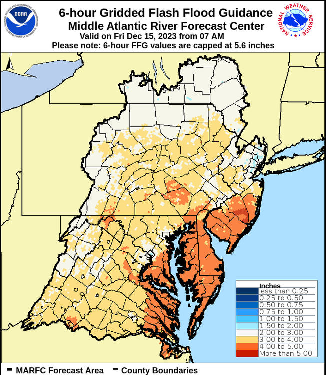
For sure. Flash flood guidance is fairly high especially in eastern PA, but this is still likely to cause widespread issues of the urban/small stream variety and some of the medium size waterways cracking flood stage. Looking at headwater guidance in the Sus Valley…Swatara Creek looks especially vulnerable for minor or even moderate flooding as well as the Schuylkill River (for minor) given the widespread agreement on a 2-3+” event of which the heaviest bulk likely comes within a 12hr timeframe. The tributaries of the Juniata (Little Juniata and Frankstown Branch) would be similarly vulnerable to at least minor flood stage if the swath of heaviest rains (2-3”) ended up catching back this way. Headwater guidance . 1hr 3hr 6hr 12hr 24hr