MAG5035
-
Posts
6,078 -
Joined
-
Last visited
Content Type
Profiles
Blogs
Forums
American Weather
Media Demo
Store
Gallery
Everything posted by MAG5035
-
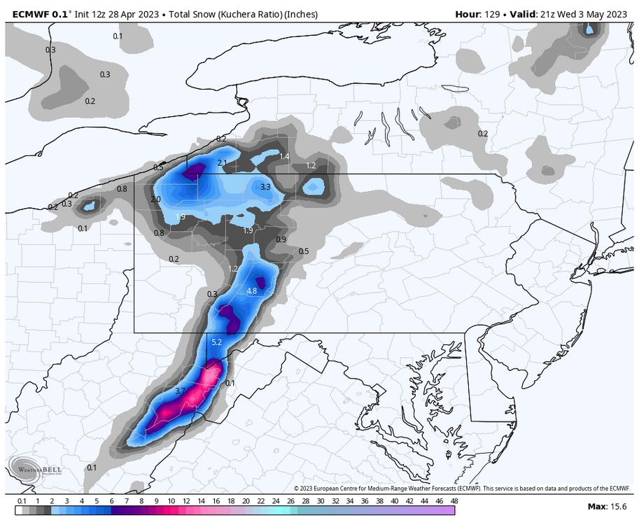
Regarding the mountain snow chances, I’m definitely intrigued. CTP acknowledges to a point, noting potential of light accums on non-paved surfaces in the Alleghenies. Given the signal on the models, I think the potential is there for a more significant event but it’s going to be highly elevation dependent. The broad brushing of the globals (esp GFS) having the high totals over all of the Laurel’s is likely overdone. The 12z 3k NAM had a presentation of accums that looked a bit more realistic IMO. When I say highly elevation dependent I mean accums will be purely driven by it. Best timeframe appears to be Tuesday as a reinforcing shortwave pinwheels through driving upslope precip in western PA. During this time 925mb temps are marginal (a degree or so above zero. Since we’re under such a significant upper level low, 925mb heights are only around 570m, or about 1800 ft. 850 temps are below zero over all of PA during the duration of all this (mainly -2 to -4ºC). Basically with all this in mind, I think accums will mainly reside at 2k feet and above. Headline worthy snow could fall in higher Cambria and Somerset areas but whether it’s widespread enough to warrant the actual headline is debatable. The best potential for more significant totals could be at an elevation above about 3k feet, though maybe down to 2,500’ish. That’ll be a key, as there’s only a couple places in the Laurels that top 3k feet. There are ridge lines that go into western MD and WV that are 2500’-2800’ or so in spots. Modeled accumulations really explode in WV because their ridge tops are much higher than that. Whatever happens, it’s certainly a cold, unsettled pattern especially the first half of the upcoming week to open up May of all months.
-
Starting to see the best rain rates of the event finally (moderate) after it being mainly a light event most of the morning as the initial heavy rain bands went up east of here. Radar looks pretty solid and the frontal passage later on likely will mean totals will have a chance to catch up some. 0.45” total for today, and 1.19” total since Friday morning.
-
Lol I can’t believe I’m going to be that guy, but the highly anomalous deep upper level low that will be anchored over the Lakes/NE during the first half of next week means business. Classic case of where was this pattern three months ago? Usual snowmap and springtime caveats apply. I used Kuchera here, which applied notably below 10:1 ratios. The 10:1 map had widespread 6” or so in Cambria/Somerset. Tuesday into Wed seems to be the primary period for this potential. 850 and 700mb temps are very cold (down to -5ºC @850mb and -10 to -12 @700mb). 925s are marginal, and suggest flake potential remains higher in the Laurels/NW mountains and not much anywhere else. Good chance of seeing some kind of accums above 2k feet or so. Could definitely see some grapuel showers anywhere else in central PA given the very cold temps aloft.
-
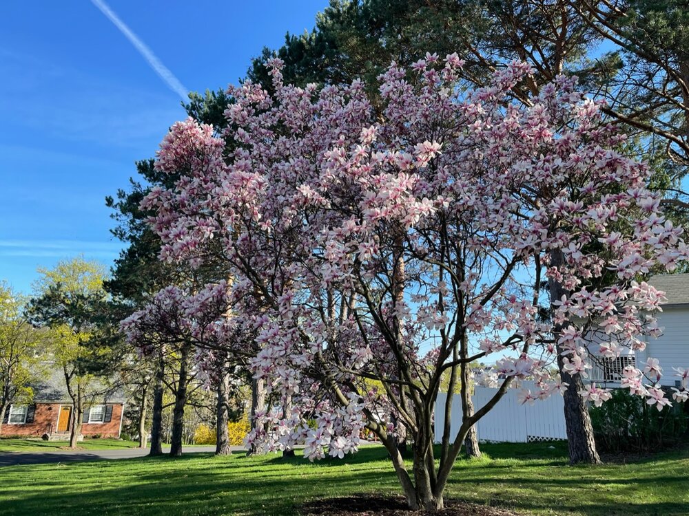
Magnolia update, yep they still bloomed haha. 85.5°F was the high today here.
-
Mow #1 is gonna be this week for me. I’m hoping my magnolia flower buds still bloom after two 28ºF nights over the weekend and 30ºF last night.
-
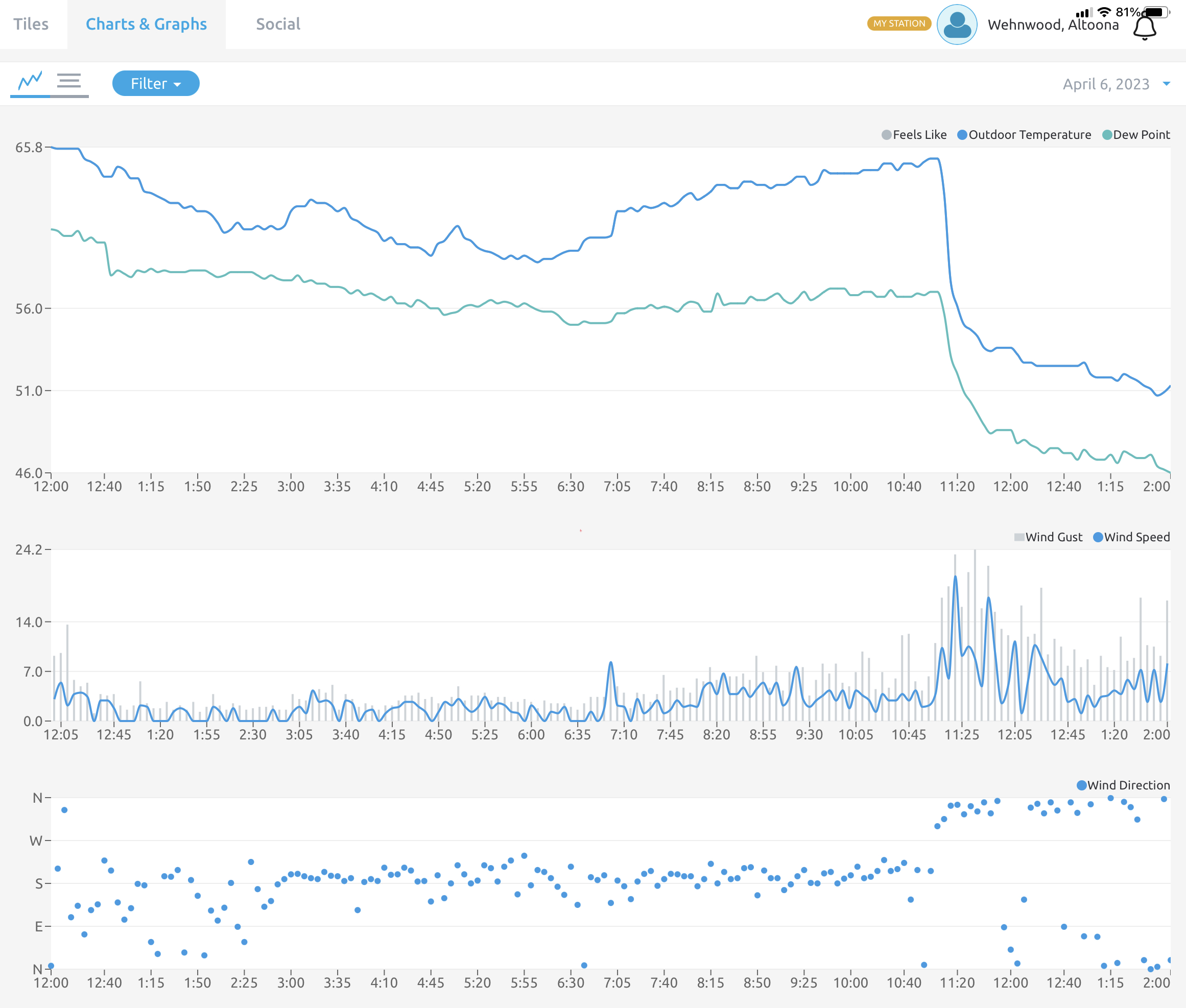
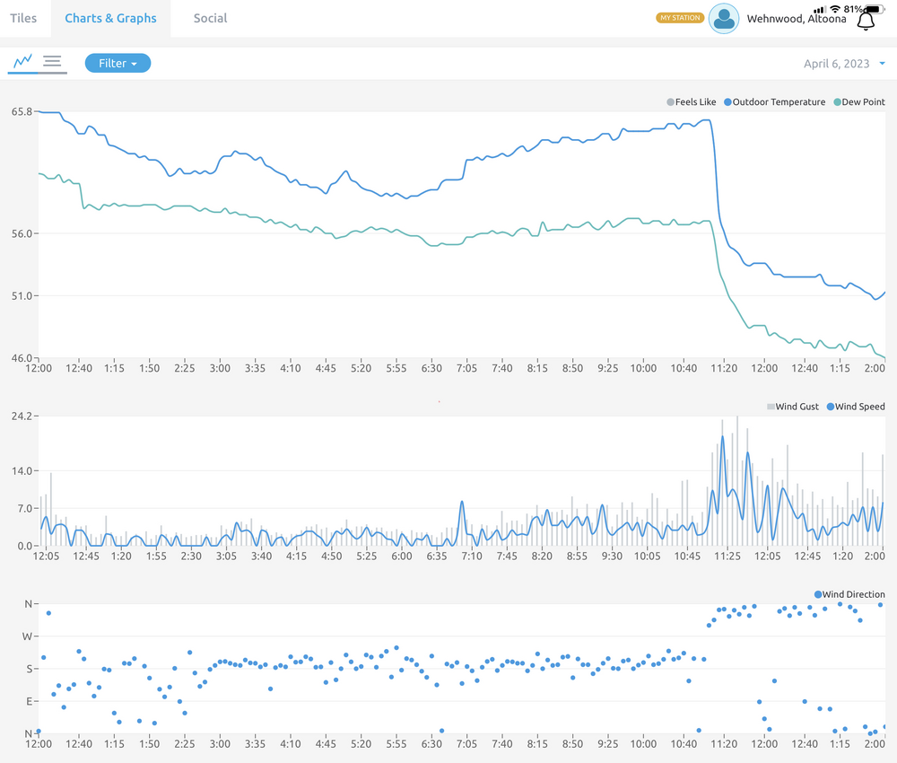
51ºF currently, a full 30 degrees colder than yesterday around this time. Find the FROPA
-
The Ides of March end of Winter 2023
MAG5035 replied to paweather's topic in Upstate New York/Pennsylvania
Half decent line of thunderstorms just came through to cap off what has been a straight up summer like day. Definitely organized and came through pretty quick. 81ºF was my high temp today. -
The Ides of March end of Winter 2023
MAG5035 replied to paweather's topic in Upstate New York/Pennsylvania
Yea I was okay in my immediate neighborhood. Main issues seemed to come from the initial arrival of that line and damage here was more sporadic like a typical severe outbreak. The two most significant wind damage incidents noted in and around town was a portion of a bowling alley’s roof blew off and took out lines and hit a house across the street and also a metal roof getting peeled off off another warehouse type building north of Altoona in Bellwood. https://www.altoonamirror.com/news/local-news/2023/04/wind-causes-modest-damage/ The large scale wind event aspect of that storm system was definitely not all that noteworthy here, the highest gust i registered on my weather station was only 34mph. -
The Ides of March end of Winter 2023
MAG5035 replied to paweather's topic in Upstate New York/Pennsylvania
Winds are starting to ramp up here, the approaching line of storms is definitely going to be interesting. Pretty impressive satellite image, it’s overlayed with wind gusts, lightning, and pressure change. Red contours are pressure rises (mb/hr) and blue is pressure falls -
The Ides of March end of Winter 2023
MAG5035 replied to paweather's topic in Upstate New York/Pennsylvania
Front arrived a little after 8 with a 39mph wind gust and a rapid drop in temps from the mid 40s to about 34-35ºF. Did have a changeover in the last half hour and the remaining precip around is currently snow. -
The Ides of March end of Winter 2023
MAG5035 replied to paweather's topic in Upstate New York/Pennsylvania
I missed this convo yesterday, but most certainly would have been a hail situation looking at the mesoanalysis stuff from yesterday afternoon. Freezing level was well above 850mb closer to 700mb. Pretty steep low and mid-level lapses during max heating but minimal CAPE would have limited storm top height and updraft strength. Result is the potential was there for only small hailstone formation and also that the storm updraft wouldn’t have carried them very high into much colder temps aloft. Rapid freezing and also layering from being caught in a stronger storm updraft can give the hail the cloudier appearance. Hail is clear when the ice freezes slower, which was likely the case with the limited convective potential and cloud top height yesterday. -
The Ides of March end of Winter 2023
MAG5035 replied to paweather's topic in Upstate New York/Pennsylvania
Just had what might’ve been a better thunderstorm than anything I saw last year lol. Really vivid lightning/thunder for March, pea sized hail, gusty wind, and 0.36” in 20 min with a max rate of 1.6”/hr. Rain spouts caved haha. 0.94” of rain on the day so far. -
The Ides of March end of Winter 2023
MAG5035 replied to paweather's topic in Upstate New York/Pennsylvania
There was even a tornado that touched down and did damage in the Los Angeles suburb of Monebello late Wednesday morning, which LA NWS recently confirmed was an EF-1. -
The Ides of March end of Winter 2023
MAG5035 replied to paweather's topic in Upstate New York/Pennsylvania
0z GFS just ripped about the whole subforum with 10”+ from that 3/29 thing. It’s definitely an interesting looking period next week with the NAO, EPO, and WPO all nosing back negative favoring below average temps most of next week and this weekend system ushering in the colder regime kind of setting the deck for that following system to possibly track favorably. -
The Ides of March end of Winter 2023
MAG5035 replied to paweather's topic in Upstate New York/Pennsylvania
Still 23°F here with a pretty brutal wind. 17°F was the low this morning. -
The Ides of March end of Winter 2023
MAG5035 replied to paweather's topic in Upstate New York/Pennsylvania
After perusing the guidance today I decided on a blend of the ensembles lol. So close.
-
The Ides of March end of Winter 2023
MAG5035 replied to paweather's topic in Upstate New York/Pennsylvania
CTP was considering issuing fire weather products this afternoon with the winds and low RH meeting criteria, but decided not to since Forestry determined fine fuels still had moisture that was above criteria threshold, that and there’s no trees or fine fuels on @canderson’s street left to burn since they all blew away lol. Similar setup tomorrow with a bit less wind that might not actually meet the criteria. Laurel’s still have or have had snow on the ground the last couple days, so can’t see that being much of an issue there. CTP notes SC PA will have lowest RH values via downsloping tomorrow. Something to consider if one wants to burn tomorrow I suppose. It is getting to that time of the year that there’s usually a heightened brush fire risk, especially since it’s been fairly dry and no snowpack in the Sus Valley and a lot of the central south of 80. CTP -
The Ides of March end of Winter 2023
MAG5035 replied to paweather's topic in Upstate New York/Pennsylvania
I was considering that potential event next week as the last good chance of something bigger before we’re at a point where it becomes much harder to line something up, though we’re likely to be dealing with periods of notable below average temps the rest of the month into early April. As it looks now, I think yesterday’s nor’easter probably will be the signature event of the 22-23 winter in the Northeastern US. Something finally took advantage of those flaming hot above average SSTs in the NW Atlantic we’ve had all winter and there were several 30-40”+ amounts to show for it in the higher/more interior parts of NWS Albany and Boston’s CWAs. On that same note, I feel that same thing probably contributed to the lower elevations of southern New England doing their best LSV impression with big snow map totals and not much on the ground to show for it. -
The Ides of March end of Winter 2023
MAG5035 replied to paweather's topic in Upstate New York/Pennsylvania
This threat can definitely come back but it’s certainly not looking great today. Models seem to be really keying in on another strong trough dumping into the SW US which supresses whatever southern stream energy that does eject out while building eastern heights. Result is no amp to strengthen or turn that shortwave up while we have plenty of well below average climo air around (our period of opportunity) and also to set the stage for an inevitable cut after that modifies. Euro 12z today vs 12z yesterday -
The Ides of March end of Winter 2023
MAG5035 replied to paweather's topic in Upstate New York/Pennsylvania
1.0” was the total last night here. 25ºF and quite blustery this morning. Max gust of 44.7mph already. Haven’t had much snow driving opportunities this winter so took the 5 mile drive up Wopsy mountain middle of last night. There was at least a 5-6” pack up there from the last few days.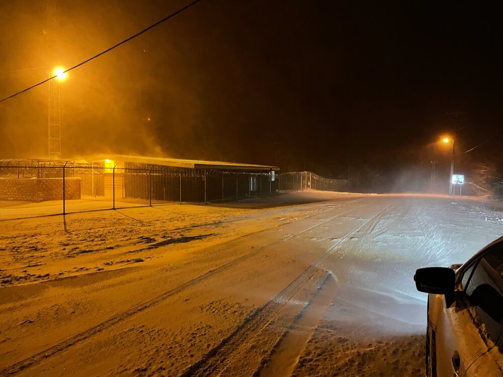
-
The Ides of March end of Winter 2023
MAG5035 replied to paweather's topic in Upstate New York/Pennsylvania
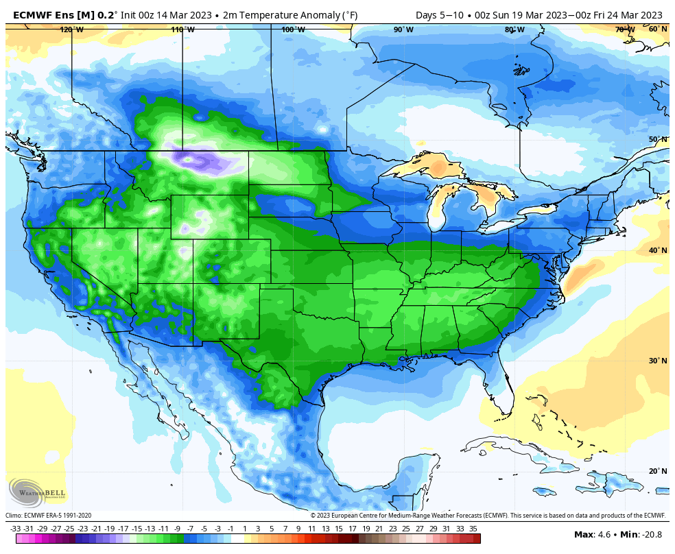
Winter has been getting closer to us since the latter part of February, as pretty much every cutting event to the lakes since then was forced to secondary south of New England. Not in time for us of course, but the interior NE and New England has been catching up. Even northern PA has to some degree too. The significant Nor-easter ongoing in Upstate New York and New England came together just a bit too late for us. We’re definitely in a different pattern regime now. Yea the MJO lowers in amplitude as it progresses into 1 and 2 and eventually the null phase by late month, but it’s literally off the chart right now. It has to be a record or near record amplitude. After spending the whole winter failing to get into 8-1-2 during more “favorable” periods, the rubber band definitely snapped in that regard… also signaling the true death of the Nina and likely incoming Nino. In the more nearer term, it’s indicative of predominantly below average temperatures mid-late month for this part of the country (and a large part of the CONUS as a whole) as this progresses to 1-2. Problem is, obviously, mid-late March climo is a different ballgame than Feb-early March. I posted a few weeks ago how the loop back of the MJO at the time was going to push the pattern change to colder than average back. From 2/22 Not a perfect take by any means from 3 weeks out but I feel the main points ended up coming to fruition. So onward from now this week, we moderate back to average-above average the latter half of the week as we have a brief spike positive in the EPO. The next system at the end of the week is a definite cutter but it ushers in a pretty major cold shot for the time of the year. It’s of the caliber we need at this point that can set up the next system to be cold enough for a notable snow swath with the right track. We have SW energy to come out following the cutter and models are going to do a variety of things with it at this range. There’s been some nice hits here and there in that 3/21-23 period, with the 0z Euro and current 6z GFS as the most recent examples of what could happen in our subforum. I like the potential of that period, and we had a big storm on pretty much those dates back in 2018.. which has been referenced as a comparable March to this one with teleconnections/preceding stratwarm/MJO/etc. Either way, these are the 5 day avg temp anomalies centered on that D5-10 period: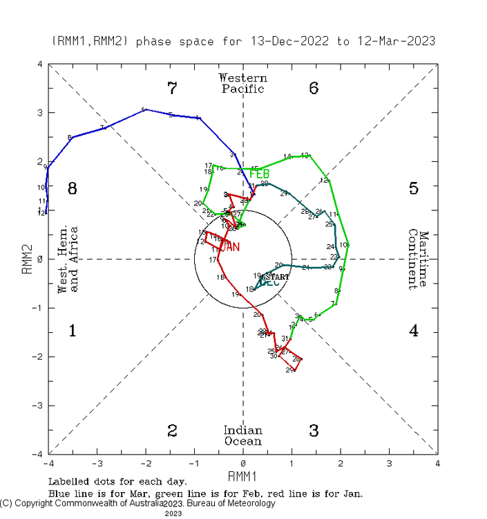

-
The Ides of March end of Winter 2023
MAG5035 replied to paweather's topic in Upstate New York/Pennsylvania
It looked like your neck of the woods made a good case for probably should’ve been part of the winter weather advisory tonight. -
The Ides of March end of Winter 2023
MAG5035 replied to paweather's topic in Upstate New York/Pennsylvania
A quick half inch here and even some sporadic road cavage out of that band of squalls now pressing towards State College. Another 23.75 hours of those conditions and maybe it could’ve compared to this date 30 years ago haha. -
The Ides of March end of Winter 2023
MAG5035 replied to paweather's topic in Upstate New York/Pennsylvania
Some steady snow has developed back this way and 31ºF. Back to a coating on the grass, minus the sun this time. -
The Ides of March end of Winter 2023
MAG5035 replied to paweather's topic in Upstate New York/Pennsylvania
Judging by the mPing reports it looks like even the DC folks are going to see some flakes out of this quick band of precip that has made it across. It delivered a really short lived light coating on the grass here that’s already gone.