MAG5035
-
Posts
6,078 -
Joined
-
Last visited
Content Type
Profiles
Blogs
Forums
American Weather
Media Demo
Store
Gallery
Everything posted by MAG5035
-
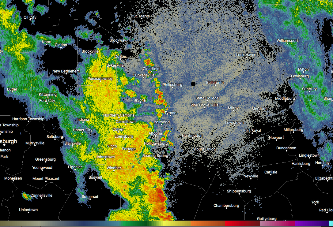
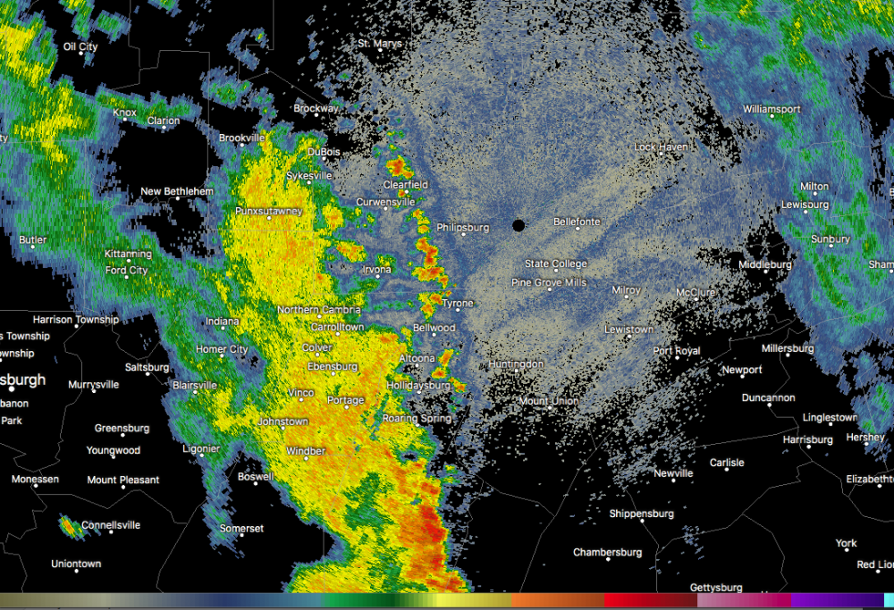
On the north side of town of course. I've had a few doses of rain the last couple days but definitely not enough. And of course same deal tonight with the real heavy stuff just south of town. Hopefully some of it bubbles up this way. On that note I'm getting rather concerned about the training going on in the southern half of Cambria (Johnstown and surrounding communities). Already flash flood warnings out and 2"+ on the doppler estimates.
-
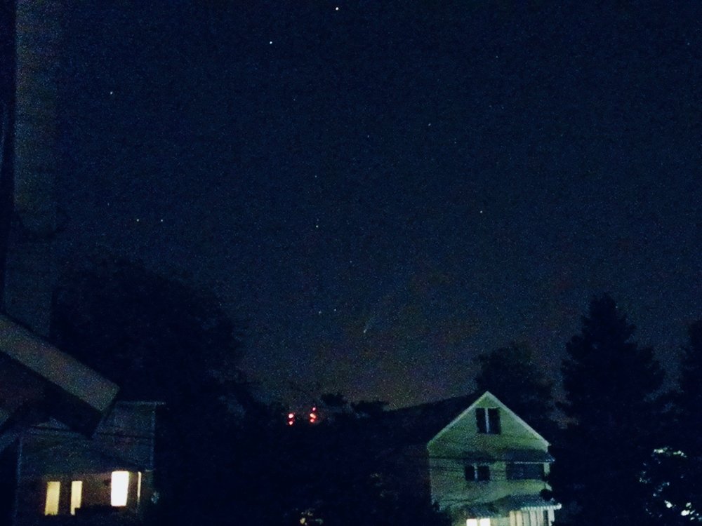
Has anyone seen the comet yet? I managed to get a pic of it Friday night from here at home. Not the greatest with an older digital camera and no tripod but still pretty cool.
-
Meanwhile I just noticed Tamaqua has incoming, again lol @Voyager.
-
I'm pretty much within the edge of the D1 zone now. Doesn't look like tonight's action is getting here either, with a split in the thunderstorm activity poised to go north and southwest of here. On the drought monitor's national map, the area of drought conditions in PA is labeled as a short term drought.. which would indicate despite it being very dry in a lot of the area that the drought hasn't progressed to one that has adversely affected the water table, reservoirs, etc.
-
Unfortunately overall it looks like we will remain in this type of regime for perhaps most of the rest of the month. It won't be wall to wall max heat but the periods within the next 8-14 days that are "cooler" are still likely to be at least somewhat above average.. which is still hot this time of the year as we're pretty much within our hottest portion of the year the next 3-4 weeks. We've been due for that wall to wall hot and dry summer July/August, although I guess some folks east of the Susquehanna haven't been all that dry lately. As for today, saw that CXY and MDT are back up to 99ºF again after falling to 97 briefly. Two weather stations on mesowest up over 100ºF (101 near Shippensburg and 100 near the MD line south of Gettysburg). Mid to upper 90s are pretty common today in the south central, especially near and west of the Susquehanna and even back here to the eastern Allegheny front where 94-95ºF readings look pretty common. Thunderstorms have fired off of Erie a few hours early by the looks of short term guidance, esp the 3k NAM.. which could allow whatever organized line that materializes out of OH to press further into the central counties early this evening.
-
I actually got a half decent downpour in the middle of the afternoon, probably a couple tenths out of it. Gotta start somewhere I guess lol.
-
Looks like the direction of the day for the rain to miss here today is north haha. It did rain a little bit last night, but what was left of what really looked like a promising area of downpours probably put down 0.05-0.1" tops.
-
Update: I might've spoke too soon. Radar's really breaking up locally with some new stuff that fired east of here and heavier action to the south.
-
Safe to say this is probably making it off the mountain tonight, finally. Or in winter terms, miss the big coastal low and get some weenie ULL snows.
-
That region of the Laurel's has definitely reversed that trend in the last few days, especially just south of JST in parts of Somerset County as we've had a more favorable setup for pop up afternoon storms. One of the first places they fire on hot/humid days around here is typically along those ridges in the Laurels. The late afternoon storms that triggered a flash flood warning in a portion of Somerset earlier (couple spots of 3-4" on the doppler estimate) were on the heels of the same general area getting a similar blob of slow moving storms and scattered areas of 2-3+ totals on the doppler estimates just the other day. Meanwhile down here, no dice again this evening. All around and not here. My yard is still in ok-ish shape, but we need hit with something in the next few days.
-
I’ve been feeling that struggle the last couple weeks haha. My location has missed out in all directions on all the daily storms... although the blossoming radar up the mountain from here might suggest the weather may have other plans this evening for a change.
-
Lol that storm that's been sitting mostly over Gettysburg is basically thumbing it's nose at @Cashtown_Coop's toasted backyard.. though looks like it's trying to reach there.
-
The interesting thing about this run of hot weather so far is we are achieving widespread 90+ on what has been a generally a pretty solid northerly flow the last few days. The good thing about that is the source region is obviously much drier than a more typical southerly or southwesterly flow would be with drawing the humidity from the south. The result is MDT at 93ºF currently with a 56ºF dew point (29% humidity) and a heat index value of only 91ºF.. for instance. So it's certainly a stretch of hot weather but it definitely could be worse. I suspect humidity will be increasing the next few days as flow reverses, which could help for more thunderstorm chances. We'll still be in the same hot weather regime with similar temps in the 90s, so as humidity goes up we may see some air quality/heat related headlines needed for the urban areas in the Sus Valley.
-
Pittsburgh PA Spring and Summer 2020 Thread
MAG5035 replied to meatwad's topic in Upstate New York/Pennsylvania
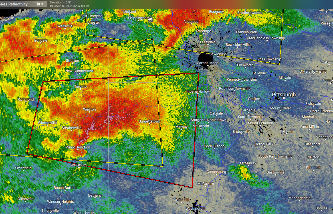
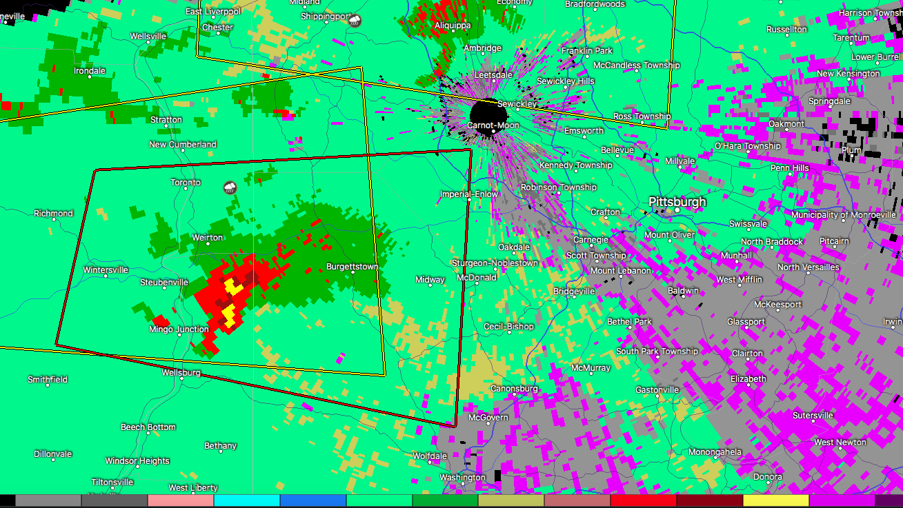
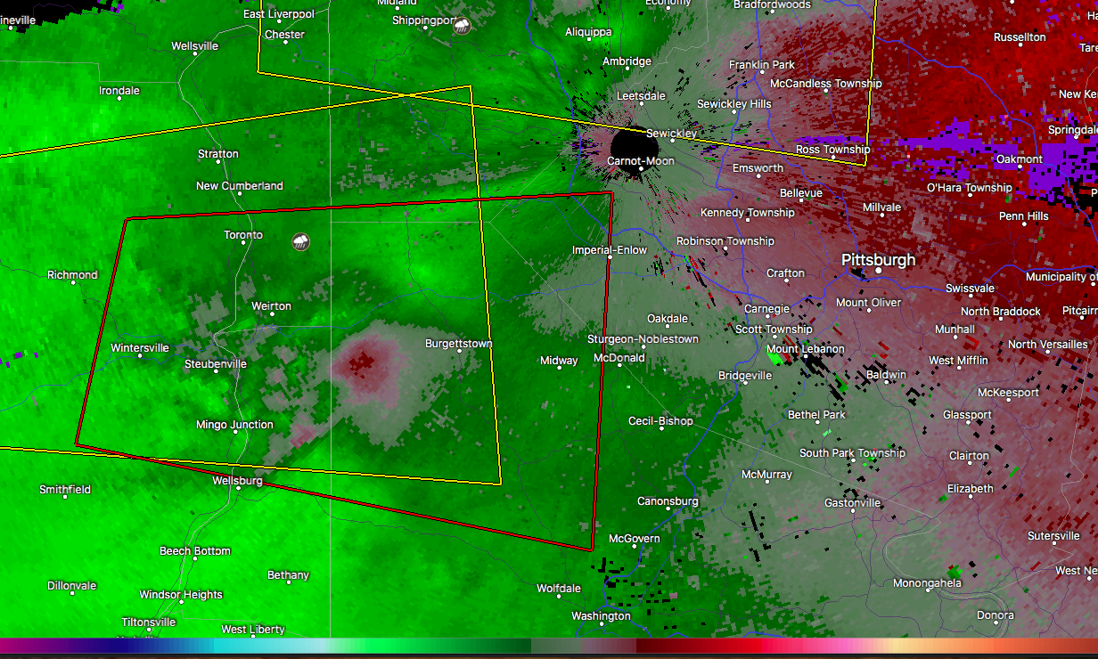
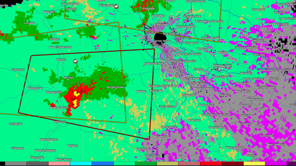
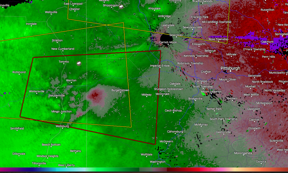
Tornado warning just issued coming into western PA from Ohio, portions of northern Washington and western Allegheny Counties. You SW PA folks got quite the severe setup, at least on paper (Mesoanalysis). Surface CAPEs over 1500 and Mixed Layer capes near 1000 coupled with modest helicity and pretty good shear/lift are putting out EHI values and lighting up the tornado parameter products. I'd be very watchful of that line of storms as it presses into SW PA and also some potential discrete storms esp south of the city. Of more immediate attention, the hook echo portion of the tornado warned storm looks to be taking aim at the southern suburbs of Pittsburgh eventually (Bethel Park, Mount Lebanon, etc). The north side of this cell likely has significant hail in it as well. Velocity isn't showing a concise couplet but the pronounced hook echo is definitely indicating rotation in this storm.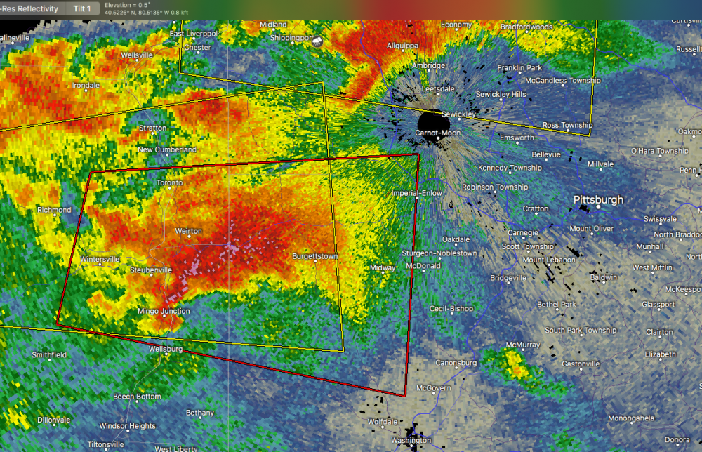
-
Devastating tornado strikes Joplin, Missouri
MAG5035 replied to Hoosier's topic in Weather Forecasting and Discussion
Also, if you go back to the 2nd page of this thread (post 45) you find a poster that quoted JoMo's last few posts before the storm hit.. the second of which saying about the sirens going off. TIme on that post was 5:17 CDT, right at the time of the warning (VTEC31) issuance. 10 minutes later was his last post about the couplet being nearly overhead. Whatever happened to that particular thread (or portion of this thread) where people were posting as the storm was unfolding? I seem to remember that folks might've been watching that first warned cell when the Joplin cell suddenly exploded into the monster tornado signature just outside of town. There's of course those couple chaser videos that show this tornado going from a developing multiple vortice to a massive wedge in about the time it takes for the doppler to make one scan. I know that's one of the many aspects of this storm that fascinates me..practically watching the whole wall cloud drop to the ground in a minute or two. -
Devastating tornado strikes Joplin, Missouri
MAG5035 replied to Hoosier's topic in Weather Forecasting and Discussion
Very glad to hear that you and your family are ok.