MAG5035
-
Posts
6,078 -
Joined
-
Last visited
Content Type
Profiles
Blogs
Forums
American Weather
Media Demo
Store
Gallery
Everything posted by MAG5035
-
Central PA 2020 Fall - The Hope begins
MAG5035 replied to paweather's topic in Upstate New York/Pennsylvania
Like I mentioned yesterday, I think the potential in this is going to be behind this Mon-Tuesday system toward the Dec 5th timeframe. GFS wasn't too interested today at 12z in that possible followup system as it actually appears to completely bury the shortwave that would cause this system in the SW. After ending at D10 with a big hitter last night at 0z, the 12z Euro has it but it's stuffed well south of PA. Canadian has it and is pretty close to being something. Way too soon and too much uncertainty to pin anything down on that, there's a lot of amplification and moving parts in this upcoming pattern. We have to see how the lead system evolves. This post Thanksgiving system looks like a doozy as we phase energy and with ample high heights over Canada it will likely cut off for a time next week. The phase is just going to happen a bit too early for us it appears, and even the 12z GFS which actually takes the low mostly under us today doesn't get the cold air tapped in. I don't think we're well positioned with the lead system and I think we're going to want the deeper and longer cutoff solutions to set the table pattern-wise for late next week. You go more progressive and maybe get closer to snow with the lead in C-PA but probably not close enough for most of us and then you probably miss the chance for a better shot late in the week if the trough levels off. The longer cutoff/carved out trough allows the opportunity to run another system while the storm track is suppressed and has ample blocking over top of us in Canada. I like our chances with that potential if we can materialize the follow-up storm late next week. The pattern would appear to favor more amplified and less progressive solutions. -
Central PA 2020 Fall - The Hope begins
MAG5035 replied to paweather's topic in Upstate New York/Pennsylvania
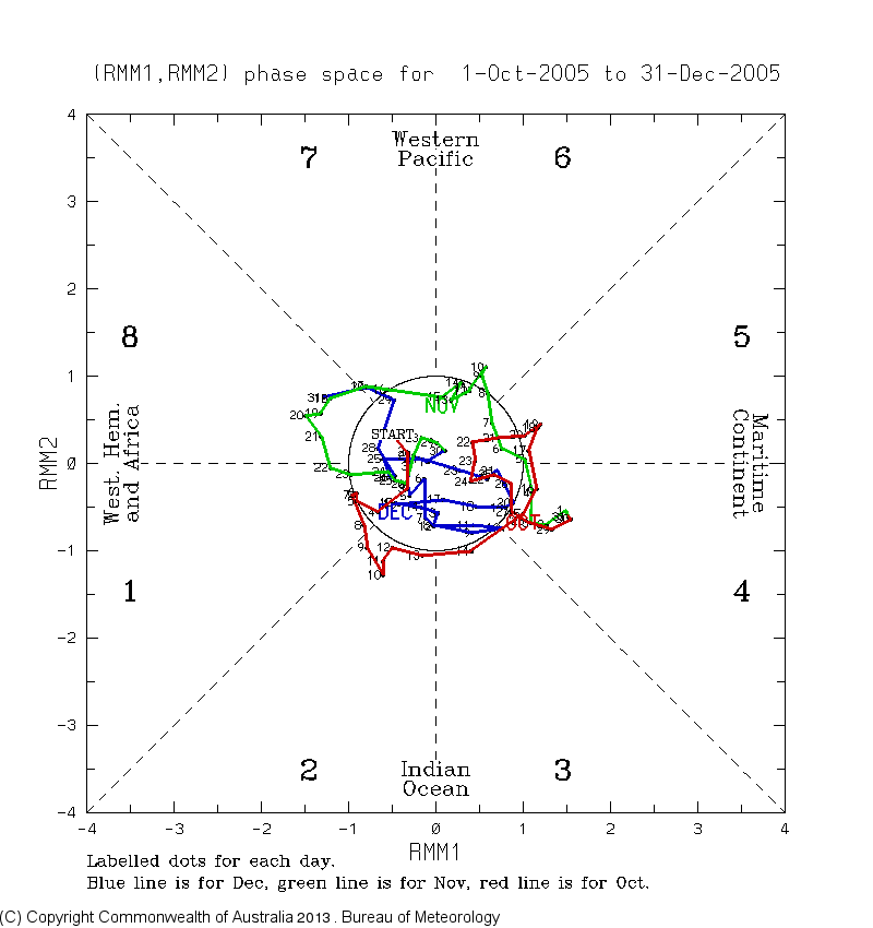
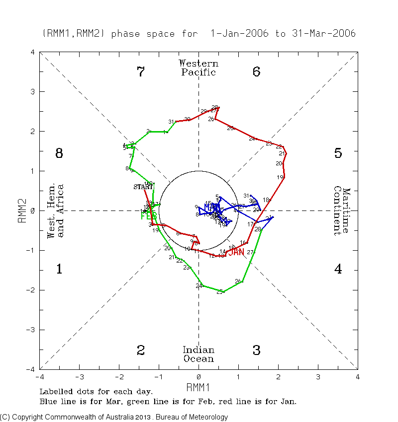
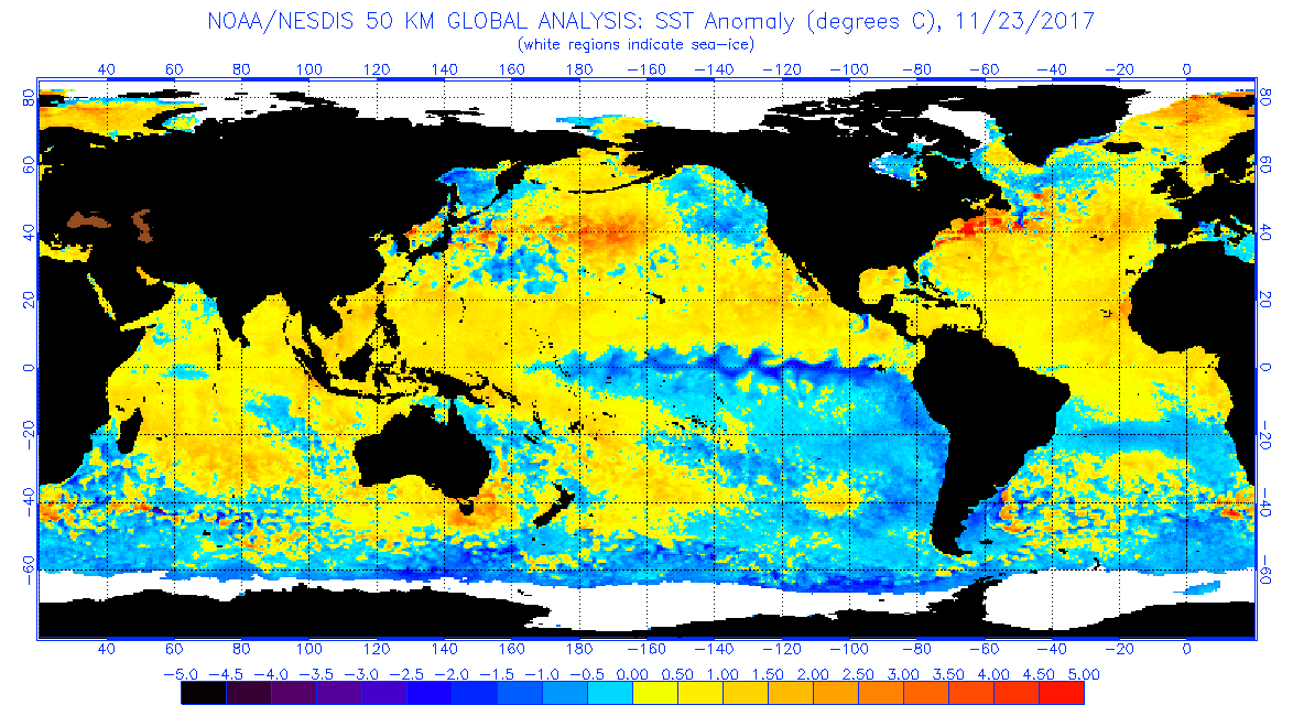
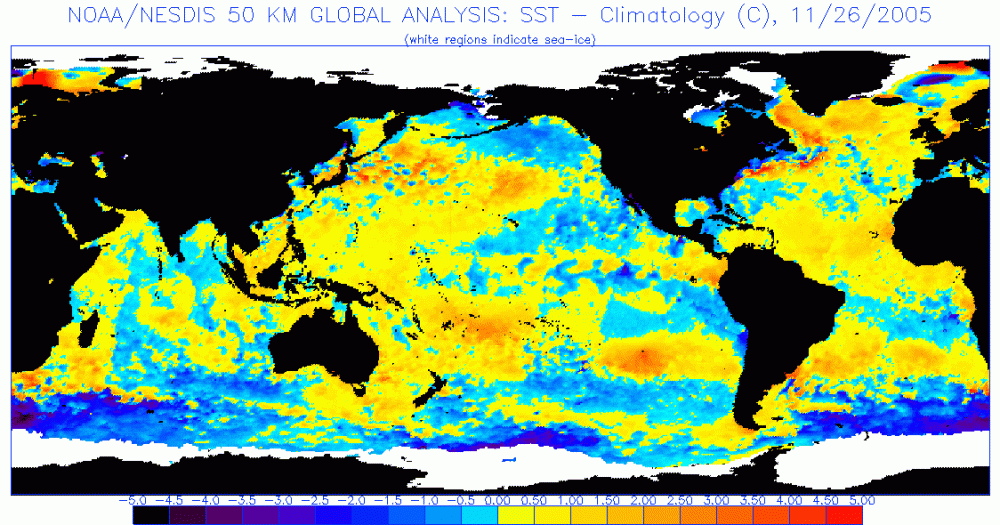
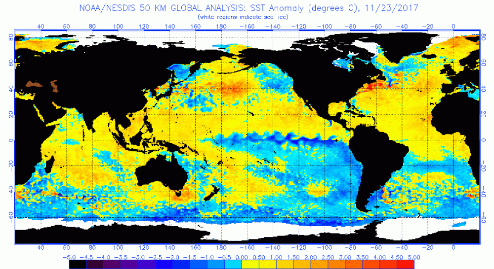
Trying to catch up here, I have been wanting to make a fuller post on the state of things and some of my thoughts on what this winter might do. @Blizzard of 93, I think this upcoming pattern presents a window of opportunity to get on the board with a more widespread event at some point during the front half of the month. Models seem to be zeroing a bit timing wise on the next major system around Mon/Tues. Really this is the first big storm of the fall/winter on the progs for the eastern half of the US that wasn't tropical or tropical influenced. Likely heading to the lakes as I don't feel we're established quite yet with the pattern/cold air regime that we need. Additionally, models (Euro/GFS) seem to be supporting early phasing of shortwaves as well, so the business end of this storm system up front is likely a pretty good rain event (which also isn't a bad thing in terms of drought relief). Now the 12z Canadian was interesting as it seemed to to be a bit east with the positioning of features, allowing a phase and deep low up into eastern PA and then NY State. That would put the western half of PA in the game. Lots of high heights up top keep the system from just shooting out and all guidance closes off the system, which depending on positioning of the features (surface low/500 low/etc) could dictate where some backlash snows and/or lake effect and upslope occurs. Somewhat more progressive could get us in a better position but I lean more towards this system being the one that could set the pattern up for the next one to have a much better shot. 12z Euro hints at that somewhat with a follow up wave late next week. Overall, that would be something I would keep an eye on as this week rolls along.. could be a bigger surface wave as depicted with that or perhaps a weaker wave that presents a lighter, but widespread event. We should hold in at least seasonable cold beyond Tues/Wed. It doesn't look like an in and out type deal like our cold shots have been to this point. Teleconnections show a nice +PNA to develop with NAO/AO at least neutralizing after a bit of a surge positive the next few days. Perhaps of almost as big of importance as the +PNA is the MJO progged to stay in the circle.. with esp the ECMWF forecast variations keeping it buried there for awhile. So trying to blend this post into the bigger picture part of the equation.. @2001kx, I was looking into his 2020 wintercast online since I didn't see it the day it was on TV. Generally I agree with his numbers and he's got the standard boilerplate Nina type influences (lots of storms cut west/mixing systems, changeable temps, etc). The last winter post I made awhile back I mentioned that I felt snow totals would be perhaps 75%-ish for pretty much all of us with the Laurels region perhaps seeing the best shot at an average season. So yea, agreed there.. but I def don't agree or understand how he's coming to that conclusion from an analog standpoint. Says his top analog is 2015-2016. What? That winter was a record breaking NINO when we're coming into this winter at a solid NINA. I don't know if he's referencing some other factor when it comes to using that as a top analog but ENSO is one of the biggest influences (especially when they're moderate/strong).. so I def wouldn't be using that. Even though the Nina is somewhat less than the current one, 2005-2006 should probably get a look as an analog. The hyperactive tropical season that also lasted late is the obvious similarity with the lead in to winter. That winter was a quick starter at the end of Nov/December that then pretty much disappeared until the Feb 2006 coastal. I think what happens in December is going to be pretty important whether or not we can achieve what I think will be a 75% type snowfall winter. I'm banking on a more wintry December than we've had the last couple years (perhaps 2017ish), and I've seen enough to have fairly good confidence with that. With the above remarks about the MJO forecast into the circle in mind check out what happened in 2005: And then thereafter Jan-Mar 2006: So one can see the 4-5-6 run that took a large chunk of January and then the Feb 11th nor'easter was smack in the middle of an 8-1-2 run. Overall, this particular winter wasn't really a great one outside of the early cold and snow in December and then the Feb storm. This is something that some forecasters (even JB) are considering as a good possibility of happening deeper into the winter... with the moderate/strong Nina driving a more dominant 4-5-6 regime equating to lots of above average in the east. It's also something I'm mindful of...but it doesn't necessarily have to happen though, especially if the Nina eventually starts to weaken. At any rate, that 2005-2006 analog isn't perfect by any means. Aside from that one being a weaker La Nina event than currently, SST anomalies in the rest of the Pac and Atlantic basins really don't match up well to what we have now. Both basins have larges swaths of above normal SST's now compared to being much cooler in 2005. 2017-2018 could get a look as an analog as well as the most recent La Nina and additionally one that the current Nina is tracking pretty close to numbers wise. That featured an Atlantic basin similar to now, although the N Pacific had more below normal SST's. That winter had its very warm stretches, esp in February.. but we fared a lot better with snow and also had the big hitter in late March and snow into April. It also had some shots of snow and cold in December (end of December was very cold). But back to the SST anomalies.. 2005: 2017: Now: So you can see the 2017 map looks a good bit closer to what we have now, with the difference still being the warmer north Pacific (looking more like this time last year there). That much warmer Pac probably will have implications in the positioning of the jet stream in the EPO/WPO realm. So lots of things to consider, this Nina is unique with how warm the northern Pacific is when comparing to any of the other recent Nina's of the past 20 or so years as well (98-99, 99-00, 07-08, 10-11, 11-12). What that might mean for our sensible weather later this winter I'm not quite sure. And even though I'm expecting a somewhat below normal winter this year snow-wise, I still expect it to be much better than last year just simply because I'm betting on the side of statistics that we don't see such an anomalous and long lasting +AO regime and extremely strong polar vortex again this winter. I feel that was what made a bad winter last year historically bad since the overall setup last winter pretty much rendered northern branch events for us nonexistent since the ++AO regime had that northern jet too high while the other systems mostly cut west with the eastern ridge. Even in a bad winter we normally still at least get a decent event or two over the course of the seasonand that one didn't even do that. I do also think we're going to need more help from the NAO realm than usual to help keep the storm track under us more if we're presented with a traditional Nina pattern. Well I really went into the rabbit hole with this, I don't usually dive too deep into these long range things but I'm trying to get better at analyzing this stuff. I am looking at this period coming up to start the first half of December with optimism though as like I mentioned, we look to have a period of opportunity. What happens beyond, we shall see. For the record I'm not writing anything off, good or bad.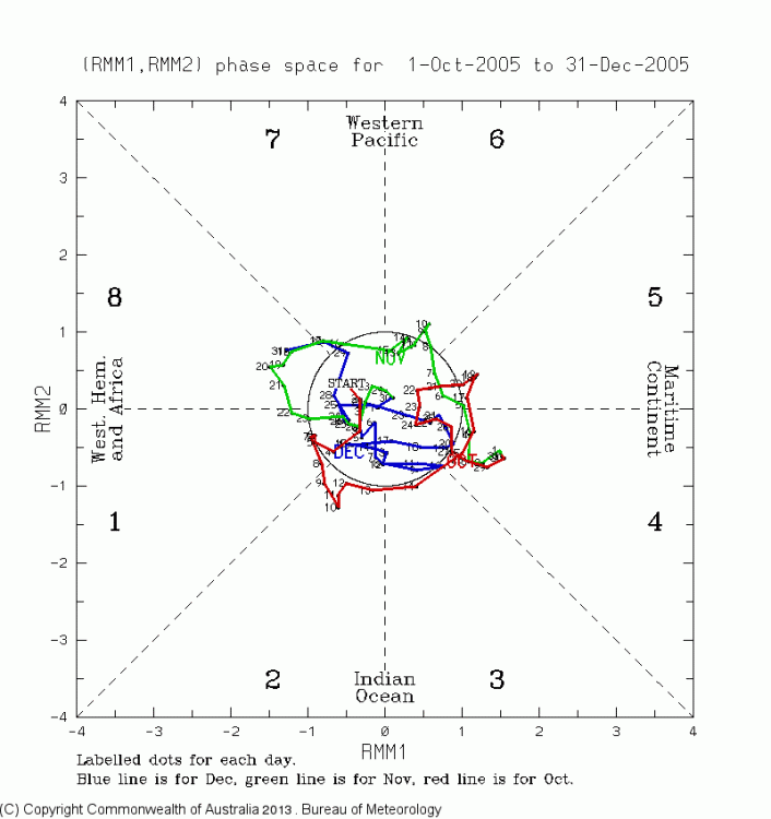


-
Central PA 2020 Fall - The Hope begins
MAG5035 replied to paweather's topic in Upstate New York/Pennsylvania
Just had a pretty feisty snow shower whiten the ground a tad. Pretty much all rimed snow pellets as the b-layer temps are a tad warm here off the mountain. I was gonna put up a pic but phone’s giving me a hard time for some reason. I might have to wait til tomorrow for someone to get here to fix my cable so I can have TV and regular internet again. -
Central PA 2020 Fall - The Hope begins
MAG5035 replied to paweather's topic in Upstate New York/Pennsylvania
Blustery with some flakes flying this morning. Still limited to the phone as the cable line is still laying in my yard after getting ripped down Sunday. -
Central PA 2020 Fall - The Hope begins
MAG5035 replied to paweather's topic in Upstate New York/Pennsylvania
The wind hasn’t been overly constant or anything, but the gusts are hitting the mark tonight apparently. It figures, the Steelers are finally delivering a stress free game tonight and my cable/internet gets taken out lol. -
Central PA 2020 Fall - The Hope begins
MAG5035 replied to paweather's topic in Upstate New York/Pennsylvania
Another big gust just took a big branch on one of my trees, which in turn took my cable line out. Taking a beating here tonight. -
Central PA 2020 Fall - The Hope begins
MAG5035 replied to paweather's topic in Upstate New York/Pennsylvania
Doesn't look like it but can't rule out a strike or two. There may be a bit of extra instability in eastern PA. There was lightning early with the portion of the line that tracked through northern Ohio with the better dynamics in the Great Lakes region. Front arrived with broken line of showers but have had some good wind gusts. Neighbor across the street just lost a tree about 15 min ago. -
Central PA 2020 Fall - The Hope begins
MAG5035 replied to paweather's topic in Upstate New York/Pennsylvania
So far this frontal passage has ripped through Ohio to the tune of almost 200k without power via First Energy"s outage map, and some outages starting to appear in western PA. Currently receiving some heavy rain just out ahead of the frontal line itself... which is moving rapidly and likely to be here in the next hour or so. -
Central PA 2020 Fall - The Hope begins
MAG5035 replied to paweather's topic in Upstate New York/Pennsylvania
Finally a good rainstorm in this area today that drew a half decent response on the local streams. Actually overachieved in the portion of PA that needs it the most by the looks of the totals CTP received (map thru 6pm tonight) with a stripe of 1.5-2+" up the center of the state. It is still stupid warm out at this hour at 63ºF degrees to go with the pretty much 100% humidity and fog. The 2 inch snowfall i received on the morning of the 2nd feels about as distant of a memory as last year with the past week's stretch of warm weather. Can't remember a stretch of November weather that was so warm with a couple days in the past week up around 75ºF or so. That's just about as warm as it can possibly get this time of the year around here. Certainly the opposite of the past couple mid Novembers, which were quite cold. I know we did cash in the early cold in 2018 with the big snowstorm but that setup doesn't come around too often. I'd rather be in the thick of this significant above average regime now than 3-4 weeks from now. We still look to linger somewhat above average to close out this week even with the passage of today's system. However, the next system slated for around Monday looks to finally send some late November/early Dec caliber chill into the region next week. Overall not really seeing anything yet on the models I'm particularly excited about in terms of anything noteworthy that sticks quite yet. There's cold opportunities but it's transient looking. We've been working a pretty strong +AO/NAO and -PNA which helped contribute to the cause of the very warm weather here. Model progs take the edge off that regime a bit but still keeping the AO/NAO positive and PNA somewhat negative. MJO working phase 8-1- possibly 2, which sounds good but this time of the year phase 8 and 1 equate differently. Using OND data, phase 8 is a bit of a tossup and phase 1 skews warm on the east coast while colder over the rest of the country. These two phases show more warmth with the SON data, which arguably might be the better one to apply right now given the late tropical activity and warmer than average waters in the Atlantic and Gulf. MJO may get into phase 2, which is a colder phase in either SON or OND.. so that might lend some support for such things. But otherwise, while we're going to finally trend colder starting next week.. I'm not seeing an established legit winter pattern emerging quite yet. And given we're still just getting into mid November, that's fine.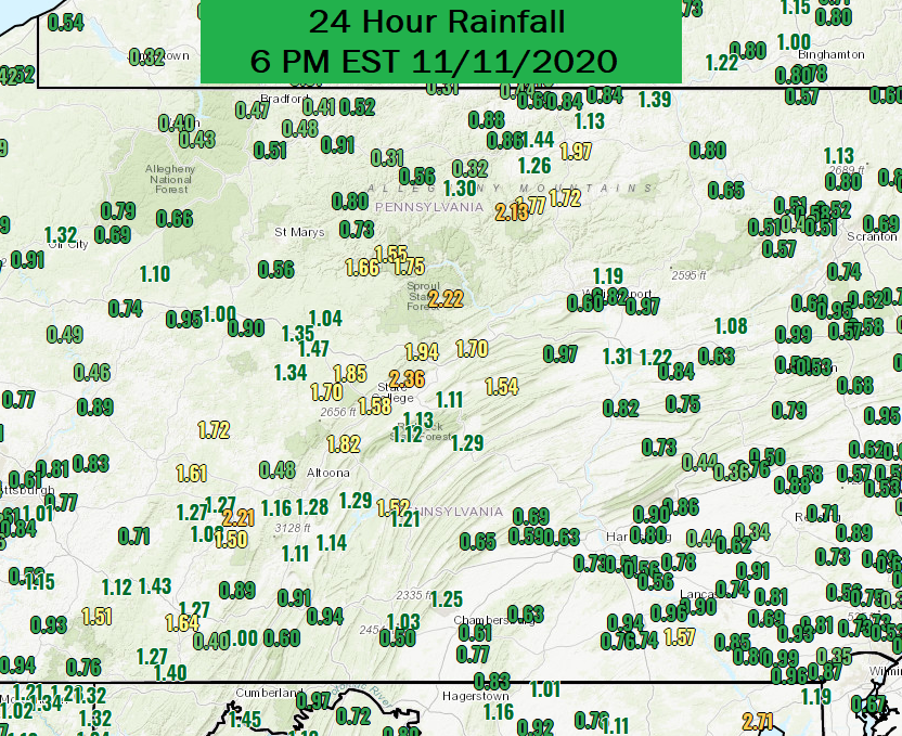
-
Central PA 2020 Fall - The Hope begins
MAG5035 replied to paweather's topic in Upstate New York/Pennsylvania
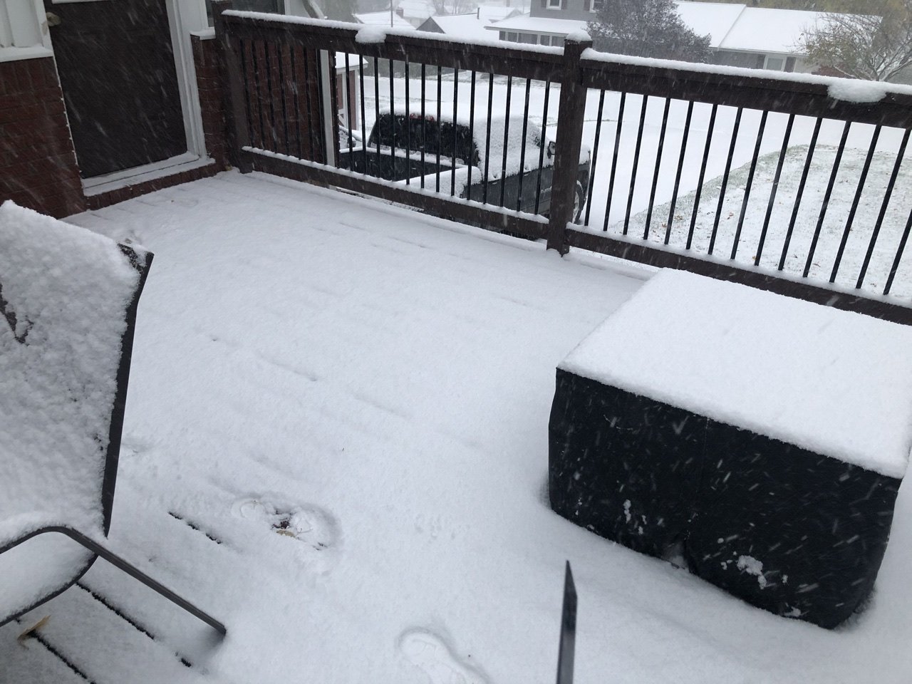
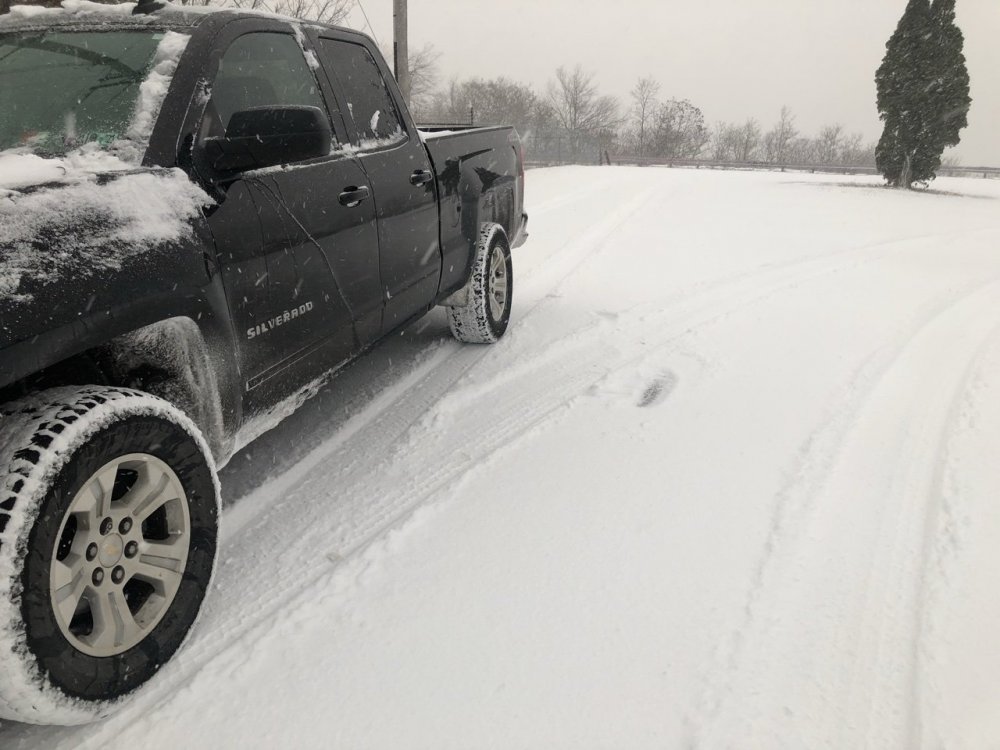
So 2.0” was what I measured with that band of snow here. Took a drive up to the top of the mountain west of town and there was probably about 3” or so up there. Roads were a disaster, especially up there where it was 27°.
-
Central PA 2020 Fall - The Hope begins
MAG5035 replied to paweather's topic in Upstate New York/Pennsylvania
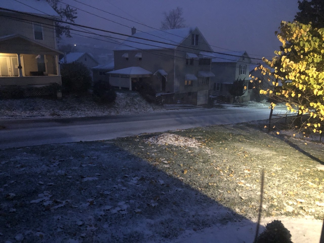
Lol if it keeps snowing like this I might be able to. I’m up to 1.3”, and that’s here at 1300’ off the Laurel’s
-
Central PA 2020 Fall - The Hope begins
MAG5035 replied to paweather's topic in Upstate New York/Pennsylvania
Got the first “roads are caving” pic of the season. Some pretty decent snow falling as the Huron connected snowband has shifted overhead.
-
Central PA 2020 Fall - The Hope begins
MAG5035 replied to paweather's topic in Upstate New York/Pennsylvania
Rain/snow mix here now. -
Central PA 2020 Fall - The Hope begins
MAG5035 replied to paweather's topic in Upstate New York/Pennsylvania
CTP added winter weather advisories for Somerset and Cambria this afternoon for up to 2-4". Could be a wild early morning in places up there with some high winds as well as a brief Huron connection to potentially enhance an overall robust lake response with this brief but significant cold shot. New snow map: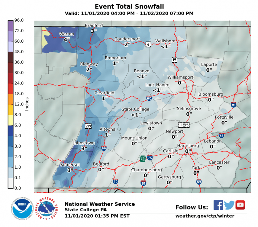
-
Central PA 2020 Fall - The Hope begins
MAG5035 replied to paweather's topic in Upstate New York/Pennsylvania
One heck of a shower rolling through with some pretty high winds. Small hail and/or grapuel falling with it (smaller than pea size) -
Central PA 2020 Fall - The Hope begins
MAG5035 replied to paweather's topic in Upstate New York/Pennsylvania
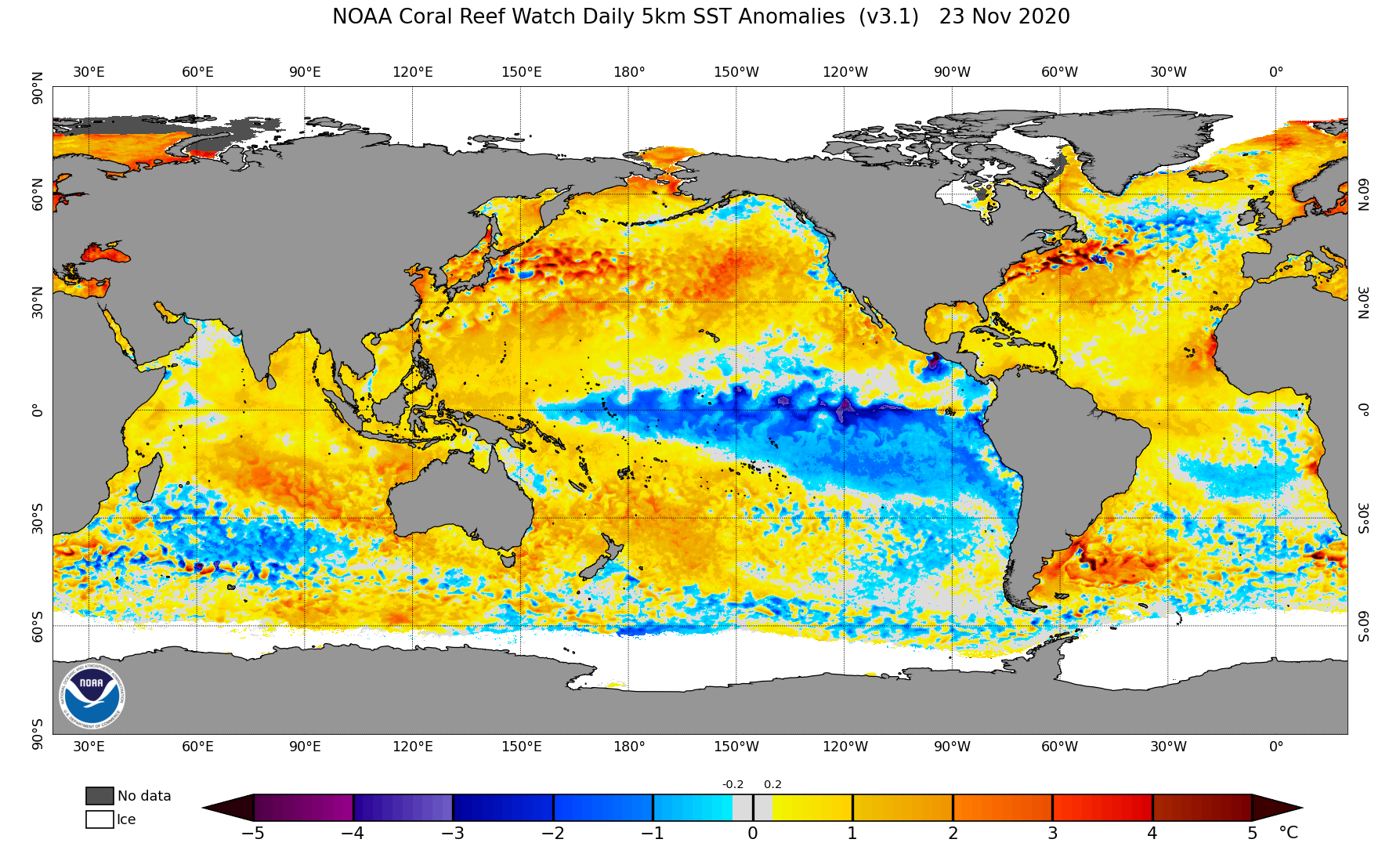
Pretty impressive early snow event in southern New England ongoing, maybe not in sheer accumulations but fact that it's snowing basically all the way to the coast (places like Boston metro). There was also some flakes reported in parts of NYC metro and Long Island earlier today along with some reports in northern/northeastern PA. Just a tad late for us, and perhaps a bit north with the boundary. This event is probably a moderate snowstorm for us in Dec/Jan. There was some entrainment of Zeta's moisture, but the remnant core rocketed northeast rapidly and didn't really catch much of south central PA. A lot of the heavy lifting yesterday in terms of precip was the warm advection precip shield and we had a lull in between that and the upper level low that rolled through in the early morning hours. The deepening at the coast was just a bit too late for us. Been watching pattern evolution alot this month to maybe catch some early hints. We've been developing solid La Nina conditions as the fall has gone on with the previous weekly ENSO 3.4 region at -1.4ºC (quite low). The new three month average will probably be out next week for ASO. The previous three month average for JAS was -0.6ºC and given October's bigger anomalies I'd look for that new value to perhaps be quite close to moderate territory. On the weekly scale we have been there (moderate) the last few weeks. To technically get the official full blown La-Nina, the conditions need to be present for at least 5 consecutive three month averages (we'll be up to two next week). But La-Nina conditions are definitely present and It's very likely to be some kind of an influence this winter. That influence has already manifested in a very active Atlantic tropical season. Standard boilerplate La-Nina winters here like a lot of northern branch, limited southern branch/phasing opportunities, wild temperature swings in a general progressive pattern, and perhaps a tad drier than average. So when I watched this current storm roll up this week, I can easily envision this happening during the winter with a strong cutoff in the SW ejecting out and drawing Gulf moisture up but not phasing with a progressive northern branch. The result can be a good snowstorm but more of a 6-8" type variety. Of course not all Nina's are standard, and other factors like the MJO and the NAO are going to play into what we end up looking like this winter. A stronger Nina later in the winter could invite more of a possibility of the MJO spending some time in the dreaded 4-5-6 or certainly at least the combo of the two things being an overwhelming influence in eastern US temps. It would probably be preferable to remain in the weak to borderline moderate range, as there isn't too many examples of moderate or strong Nina's having notably snowy winters around here analog wise. Will be interesting to see how the strength of it evolves as we get into the front end of winter. -
Central PA 2020 Fall - The Hope begins
MAG5035 replied to paweather's topic in Upstate New York/Pennsylvania
There was also this slightly unprecedented event on this date the very next year.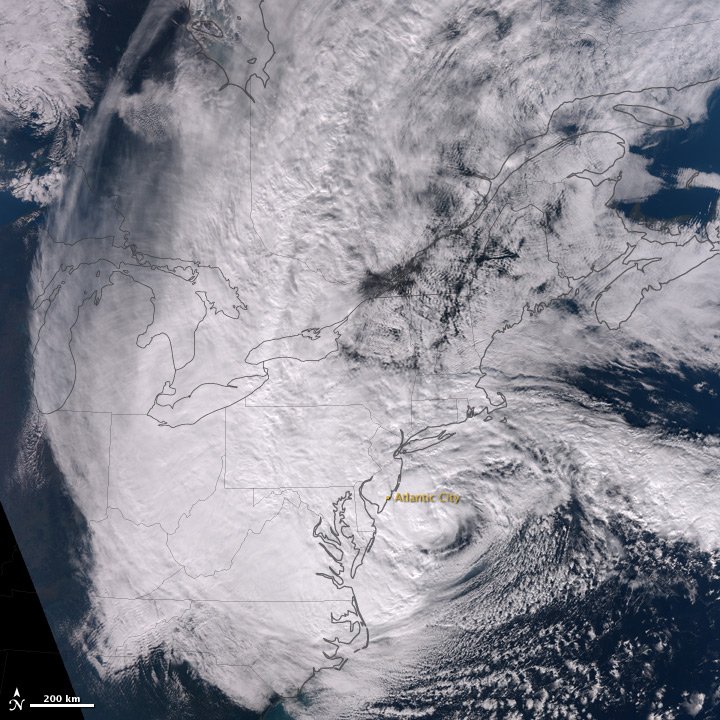
-
Central PA 2020 Fall - The Hope begins
MAG5035 replied to paweather's topic in Upstate New York/Pennsylvania
Some lighter rain currently, with some heavier stuff out near Pittsburgh likely to move back in soon. It's def been quite a rainy day here... and also somewhat breezy with a stiff wind out of the NNE. Need this to return in about a month and a half. Speaking of flakes... looking beyond today's system to the end of the weekend into Monday, we have a very strong frontal passage progged for later Sunday. This brings -8 to -10ºC 850mb air into all of PA by Monday morning. Brief window with this cold shot but it's looking to be a potent one that will present a 6-12hr period where we light up the western/central PA counties with snow showers and even squalls for the first time. The NW snowbelt could get some accumulations out of this as well as lighter amounts into the Laurels. Reasonable chance some scattered action gets into the Sus Valley in the form of wet flakes and/or grapuel mixed in Monday. The anomalies with this airmass at 850 are in the -10 to -12ºC range below climo for the first half of Monday. -
Central PA 2020 Fall - The Hope begins
MAG5035 replied to paweather's topic in Upstate New York/Pennsylvania
The progressive pattern kind of limits the potential. If we end up with the further south track, it'll likely be because it ended up with a more progressive storm and you don't have as much time to get much of a changeover. Zeta runs out in front of the closed 500mb low, and the weakening 500mb low slides east just under us and doesn't really phase with the northern branch. This is a really big early season snowstorm if these things phased together with the cold available nearby, but we're too progressive. I think that far northern part of PA does change over at the end but probably the inch or less variety slushy accumulation.. pretty much your guess. -
Central PA 2020 Fall - The Hope begins
MAG5035 replied to paweather's topic in Upstate New York/Pennsylvania
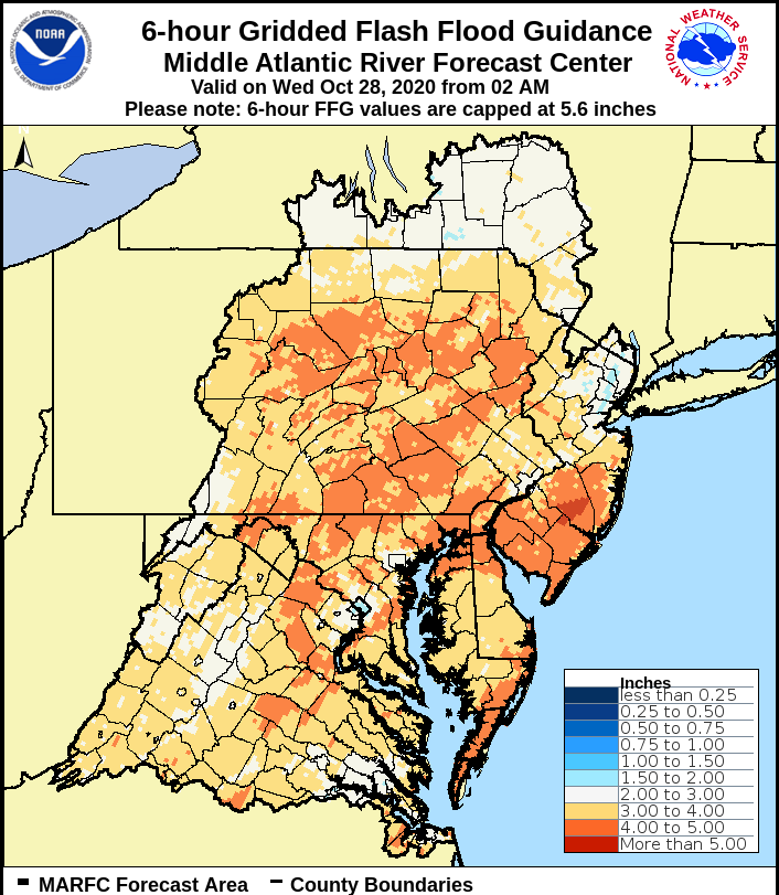
I think the whole subforum is basically locked into the washout Thur into early Friday for at least an inch or so. The only question now with the rainfall is how much of PA sees the more excessive 2+ totals, which is likely going to hinge on how far the remnant low of Zeta presses north before getting arced eastward. This morning's WPC map really knocked that down from yesterday.. with only the southern tier below the turnpike seeing 2" or more now. They seem to be factoring more heavily the GFS/GEFS in that makeup. I personally expect a lot of 1.5-2" type amounts in the subforum, with perhaps the far NW near an inch. If Zeta gets high enough and tracks just south of the Mason-Dixon line, that would likely send it's swath of more excessive rainfall rates directly associated with the tropical system itself into a good portion of southern PA. Flash flood guidance is through the roof, and thus we'd need a widespread 4"+ rainfall in 6 or 12hrs to see any notable issues in that department. We'd be hard pressed to see that even if Zeta sent it's swath of heaviest precip right through the heart of C-PA. Either way, this will be a very beneficial rainfall.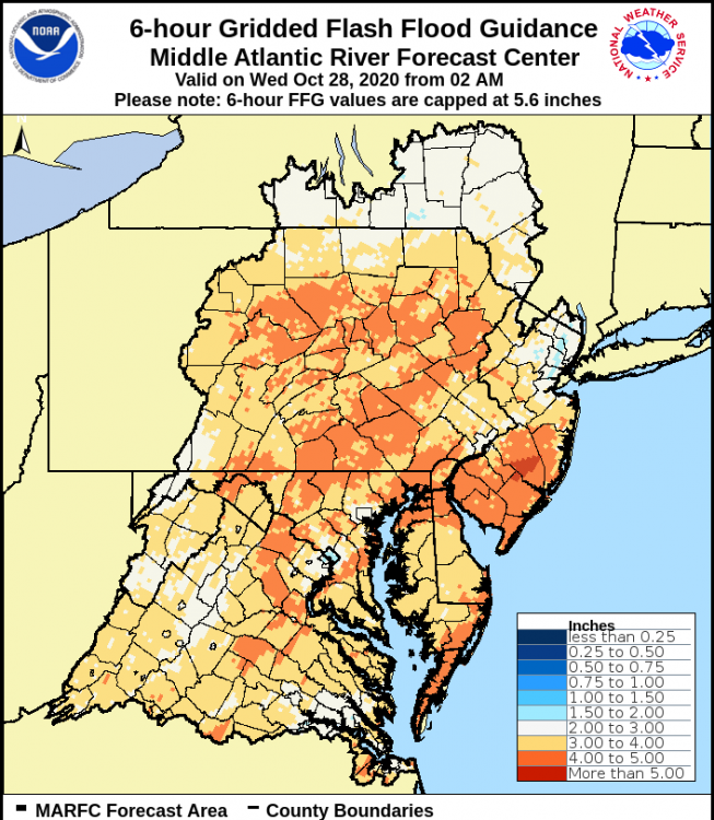
-
Central PA 2020 Fall - The Hope begins
MAG5035 replied to paweather's topic in Upstate New York/Pennsylvania
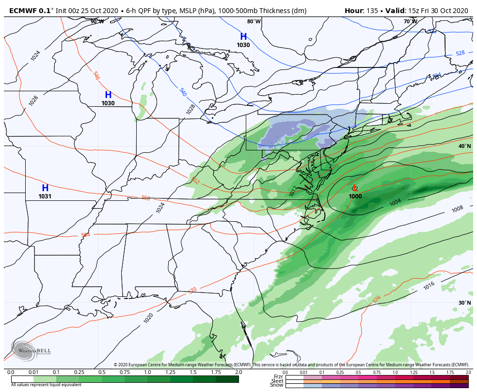
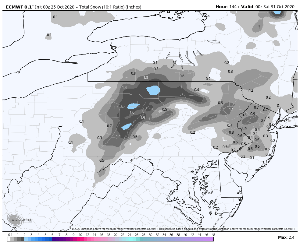
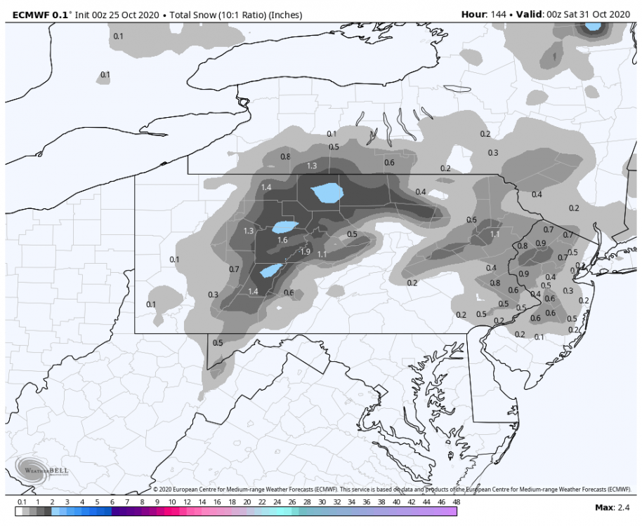
Well, the way too early look at the 12km NAM looks fun. 984mb low sitting dead center on the NJ coastline at 84hrs with a changeover starting in NW PA hr 78 and by 84 is showing approx 2/3rd of PA changed or mixing. And that's after a basically PA-wide 2"+ of rain has fallen. Def in the Euro camp with the souped up coastal low (though 18z Euro run wasn't quite as wound up). All normal NAM disclaimers aside, I do like to see what it's looking like when a storm is just getting into the edge of it's range in comparison to especially the Euro. Here's the kind of snow accumulation makeup we're seeing via the latest Euro ensemble probs. It's quite a sold snow signal for NY state/VT/NH and into a good bit of southern New England. Showing the probs of 1+ in 24 hrs, which shows how far things could reach with a potential changeover. I will mention that there are half decent 3"+ probs down to about US 6 in the northern tier of PA, those probs and the 6"+ ones focus on NY State/VT/NH/northern MA/southern ME. Couple 12+ probs show just in the Adirondacks and also Green&White Mountains. So to simplify, the Euro ensembles are liking a general 4-8" type storm centered in those aforementioned northeastern locations. The 18z GEFS is similar placement wise, just simply less overall since that op and ensemble have been less amped.
-
Central PA 2020 Fall - The Hope begins
MAG5035 replied to paweather's topic in Upstate New York/Pennsylvania
I see the Euro op continues to show the potentially snowier solution, which is certainly on the table for the north central counties and possibly the Laurels as well. A quick look at things shows the Euro/Euro ensemble has a notably sharper 500mb trough than the GFS/GEFS and thus a much deeper surface low. Pattern is somewhat progressive, and that probably limits the amount of phasing where we'd see something much wilder in the wintry department here. But either way, I think even a compromise of that guidance would support a solid chance of flakes in the C-PA high ground towards the end of this late week system. The chances look a lot better further up into the NEUS, with even the immediate interior of southern New England showing solid snow on both models. Seeing snow nearby or even some flakes here at the house to end October would be nice.. although I'm eyeing up the big time rainfall potential being presented with an already sizable mid-latitude system on its own PLUS yanking up Zeta into it. It's one of those setups that could stop the immediate short term effects of our drought in its tracks.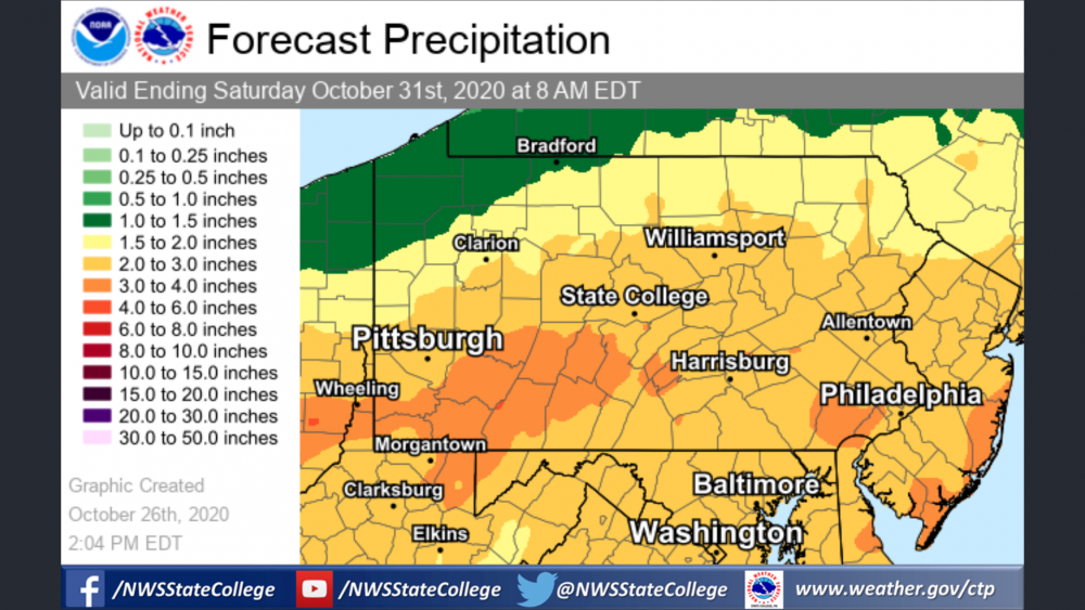
-
Central PA 2020 Fall - The Hope begins
MAG5035 replied to paweather's topic in Upstate New York/Pennsylvania
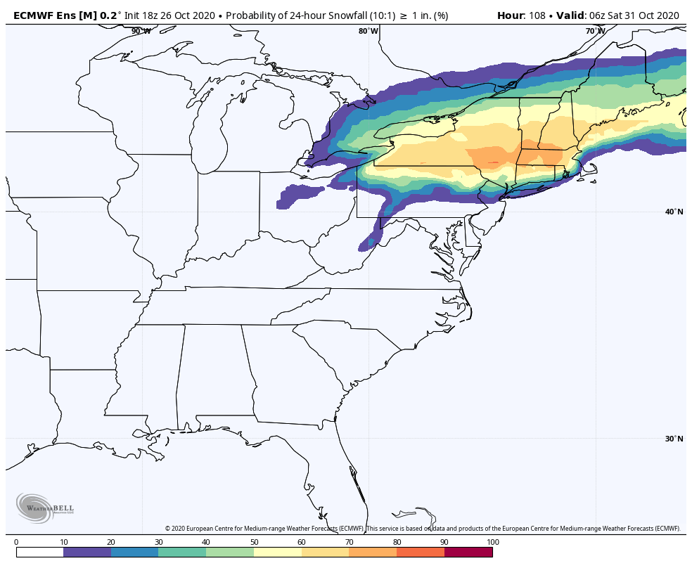
Becoming more evident on the models that the bigger ticket storm system this coming week is starting to show in the Thur/Fri timeframe over seeing much precip early week with the weaker waves running the jet through PA. Also becoming evident is this system is presenting a Northeast snowfall potential. Both GFS and Euro showing a drawn out, possibly two part system with the front part of the overall system providing the much needed rainfall we all need and the second part associated with a robust closed 500mb low and increasingly available cold bringing more rainfall and a changeover to snow somewhere in the NE dependent on track. I posted the GFS having the snow into the higher areas of C-PA the other day and tonight the Euro has it while the GFS is on a more northern track attm that gives the interior Northeast from NY state north a pretty decent early season snow. Both indicate tropical shenanigans from the Gulf that may charge things up more.. hopefully in the rainfall department. I'd look for any snow threat to be of the elevational variety of course, with the Laurel's/N Central/Poconos the favorites if we get the track we need... but here we go. We're at a D4-6 event now, not out in fantasy land. Euro:
-
Central PA 2020 Fall - The Hope begins
MAG5035 replied to paweather's topic in Upstate New York/Pennsylvania
The real question is will the AC still be running? Lol -
Central PA 2020 Fall - The Hope begins
MAG5035 replied to paweather's topic in Upstate New York/Pennsylvania
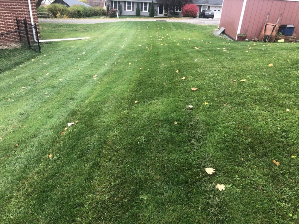
Despite continued dry weather overall and very low streamflows, we’ve had just enough rain this fall for the grass to make a rip roaring comeback. Still quite active despite actually having several frosts and a freeze last Saturday.