MAG5035
-
Posts
6,078 -
Joined
-
Last visited
Content Type
Profiles
Blogs
Forums
American Weather
Media Demo
Store
Gallery
Everything posted by MAG5035
-
It was a concern I initially had, mainly because of timing and getting the systems too close together was my worry. As this has evolved the last couple days it doesn't appear to be as much of an issue, especially on the Euro. That has generally been the most aggressive model with northern extent on this first event and it's been subsequently pounding the Mid-Atl/NE with the main system regardless.
-
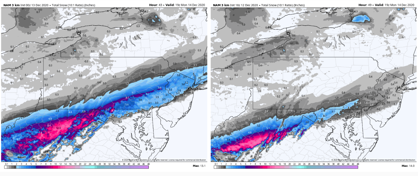
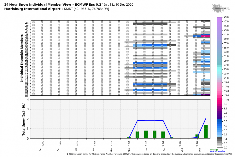
I've been away today and haven't had much time to scrutinize models too much, but vs the 18z NAM this first event is way more robust on the 0z. 0z on the left, 18z right

-
We’re definitely looking good at the moment, I’ve noticed the globals are starting to solidify the NW extent of the precip shield which is a good sign for getting west central PA and the Pittsburgh folks more involved. The Canadian op still seems the most SE with the axis of heaviest snow, but looks like the CMC ensemble align a bit more toward the GFS/Euro. Euro is def the most amped, pretty much representing a nearly best case scenario for most of our region save for perhaps a period of p-type issues in York/Lancaster. A simple blend of everything puts most of C-PA and all of the Sus Valley in a pretty good place. All of that for Wed/Thurs and the GFS/GEFS/CMC ensemble are showing more support for the Euro’s more robust initial wave and lighter snowfall potential in at least the southern tier of the state Monday.
-
Man I just looked at the Euro and almost fainted lol.
-
I'm going to wait a couple days to see where this goes before I start making comparisons, but I got a couple in mind.
-
The Ohio Valley low is going to be important for you and the western part of the state from the Laurel's west. The Euro had the stronger low I was posting about and it responded by getting better precip into western PA.
-
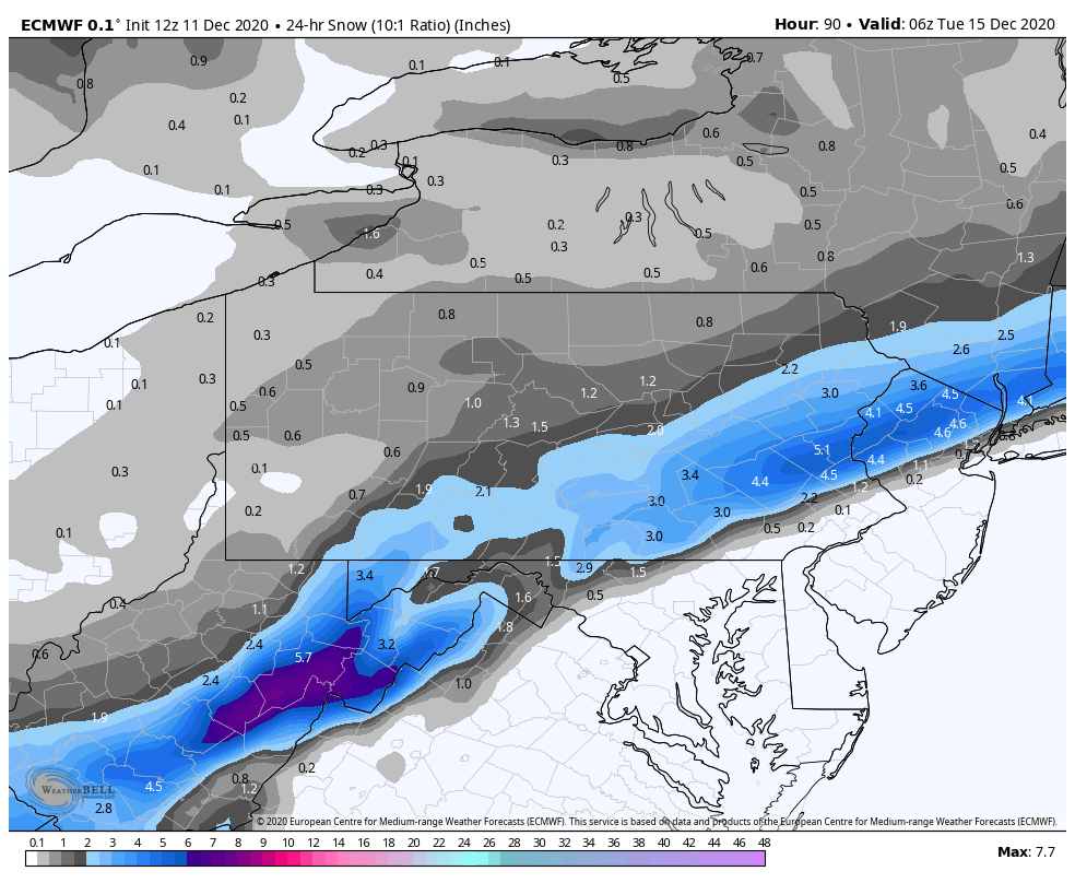
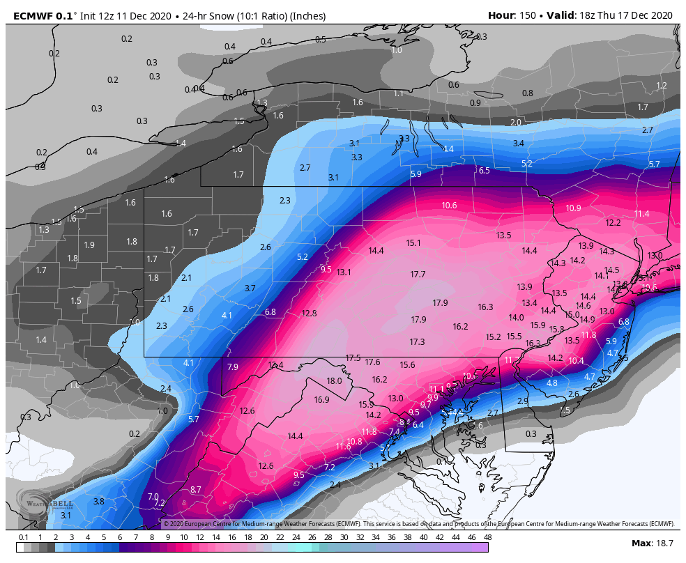
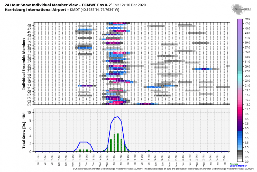
Well Euro is, snowy lol. What a hit on the eastern 2/3s of the state. Some snowmaps, these are 10:1 maps and i'm using 24 hr snowfall to separate the two potential events. This is Monday's wave, as Euro continues to support a snow event with that system: This is Wednesday/Thurs:


-
I'm not really worried about temps for any of us in here right now, we don't want to force the storm too far under us with how it's being modeled on it's coastal development starting off the Carolina coast and coming up. The Canadian flirts with having that heavy snow axis just southeast of a lot of us in here, the disclaimer being that this model has been the furthest southeast the last cycle or so (minor event yesterday at 12z) and it has really come back around. The Euro has seemingly been the most amped, and that has only introduced p-type issues to maybe the SE half of Lancaster for a part of the storm. We'll see shortly where we're at with the Euro at 12z. Really shouldn't be afraid of a bit more of an Ohio Valley low either. We have the setup for the big Miller B transfer to carry over a snow swath across most of PA. This is not going to cut, and we have a good high progged to be in place. A bit stronger of an initial low could imply a more robust precip shield associated with that and prolong the duration of the storm for especially the central and SW part of the state.
-
The Canadian's Kuchera map would be a good candidate for their snowfall forecast lol.
-
Lol, well the 0z Euro not only got some light snow into PA with Monday's storm.. but still crushes the I-81, US 15, and back to the I-99 corridor in central/eastern PA. Western PA more involved with at least 2-3" for Pittsburgh and surrounding SW PA. Some mixing in Lancaster Co. with an accumulation gradient NW-SE in the county. Def quite amped.
-
Storm's back on the Canadian at 0z although it only really catches the LSV below the turnpike. More of an I-95 storm, especially in the Mid-Atlantic region. This kind of represents my biggest fear with this storm potential given the magnitude of the -NAO being forecast. Certainly much more so than a cutter or mixer.
-
I was just looking back and I haven't had a snowfall greater than 2 inches since March 3, 2019. So heck yea, count me all in on Tom,Dick, and Harry WX's 20-40" inch snow forecast lol.
-
Don't want to get too greedy haha. Yea this Monday event could catch far southern tier but honestly I think i'd rather that stay out of the way and not end up somewhat deeper and slower as this 17th system has better potential to be a big C-PA wide event. I know I personally don't want to see something more suppressed or a forum dividing type deal out of something which could dump a good bit of snow given the setup being presented. If you look at the Euro's 12z ensemble mean at MDT, there's some members that get a snow event Monday. Those particular members subsequently are ones that show little or no snow for the 17th. Hard to tell with the 18z ensemble that only goes to 144 where the 17th event is just getting into, but you can sort of see the same general theme. 12z Run 18z Run
-
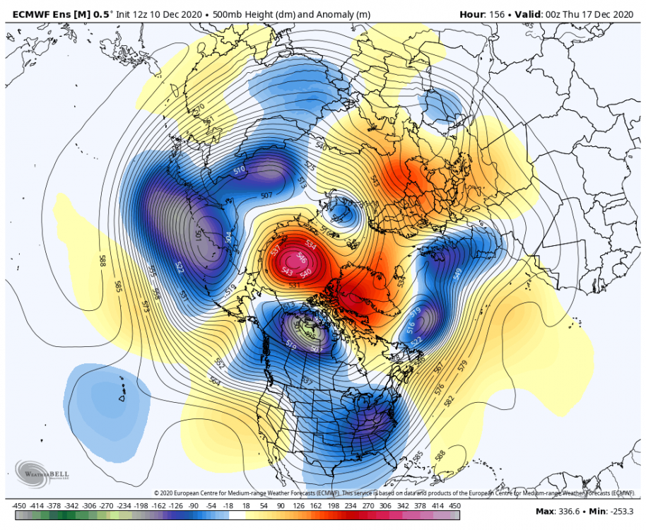
Wsmptwx FTW on the 12z Euro haha. The Kuchera map gave him about 30". This seems to have a pretty solid showing on the ensembles today, even on the Canadian ensembles where the op whiffed today at 12z. This potential event definitely has my attention now. That NAO over the top blocking driving the storm track down is definitely a beautiful thing (hopefully not too much of a beautiful thing). The decent 500mb feature and longwave trough being modeled that drives this doesn't look overly complicated either, e.g. needing a thread the needle phase to make it pop.
-
The GFS is def more miller B in it's evolution with the Ohio Valley low. I'd argue that scenario probably has more precip hanging back over most of the state, but the seemingly early takeover of the coastal definitely would take away from the actual central part of central PA and western PA in that scenario. Pretty close to last night's Euro. That looked like more of a straight miller A with only a little bit of surface reflection to the Ohio Valley. That probably could have more precip on its NW quadrant too. Not going to sweat those details though. Models are starting to see this particular threat and that's a step in the right direction.
-
Models are all over the place with features in this prospective period later next week, which is to be expected to at least some degree with the general split flow regime we're being presented. I think the models each showed their own individual way this could evolve, and everything's on the table here including the Canadian's big ticket item. They're pretty solid on the weekend system that cuts, which doesn't look too prolific with rain. After the frontal passage and reestablishing of seasonal air early next week it's a free for all. Euro has been occasionally toying around with a followup wave pretty close behind the weekend system. GFS/Canadian haven't been all that interested in that. They've been developing another wave late next week here and there with the Canadian obviously having the big one today. Euro hasn't shown much with that timeframe, actually seeming more northern branch dominant on today's 12z run. GFS has seemed to have had more cold air issues when it does present a storm solution with really not engaging the northern branch south enough. Kind of a worry of mine personally given that the forecast +EPO was seemingly the one detrimental teleconnection that could screw a storm up that does materialize. Suppression is also a concern with the right (wrong) timing of features given the -NAO forecast. I'd say I'm reasonably confident something eventually materializes at some point the next couple weeks with the said forecast -NAO/AO regime and overall lots of high heights near the pole, which might be just enough to overcome the +EPO and run a system under us or at least present us with some frozen precip in an imperfect storm scenario. It's definitely a "must score" situation as any longer term sustained -NAO/-AO is certainly not a given.
-
I doubt there will be the kind of complete and thorough shut down/stay at home we had back in the spring. I think new restrictions will target stricter limits on gatherings (or no gatherings outside of household), probably go back to takeout only for bars/restaurants, and perhaps reinstate some sort of capacity limits on grocery stores, bigger retail, etc. I'm speculating of course on those specific things, but Wolf had just said on Monday "there were no plans to go back to return to the red-yellow-green designations that were so controversial in the spring." I'm not sure how much of a difference that would make anyways really when a lot of spread could be being driven from private gatherings/parties. It really boils down to people themselves actually being reasonable and taking at least some degree of caution/responsibility. This part of PA is in rough shape. The next county over in Cambria, which includes Johnstown, reported Monday the 2nd highest positivity rate of any county over 100k people (per capita) in the COUNTRY over the last two weeks and over 100 deaths since the beginning of November. https://wjactv.com/news/coronavirus/grim-situation-in-cambria-county-as-covid-cases-explode-to-second-highest-rate-in-nation.
-
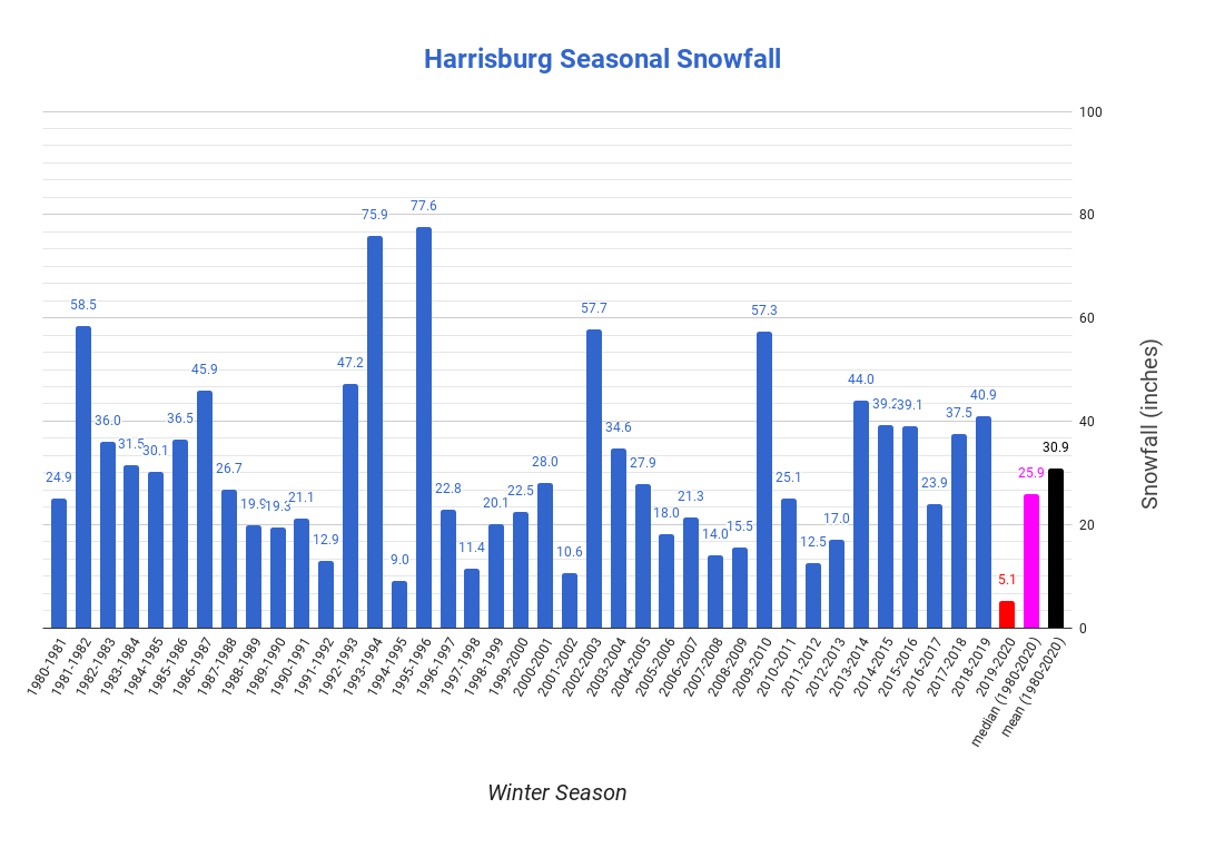
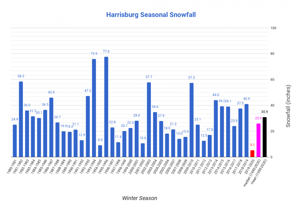
I think we should keep some perspective on the fact that Harrisburg has had 5 above average winters just in the last decade (5 of the last 7 winters to be more specific). I mean you can put the asterisk on 2015-16 that like 30 of the 39 inches came from Jonas but then you'd have to do the same thing for 82-83 that featured the 83 blizzard in that super Nino winter as well (25 of the 36"). So yea last year sucked, I think we're all aware of that. But I can pick out collective bad periods (88-92, 96-02, 05-09, 11-13, etc), or overall just point out that in this 40 year chart that 23/40 were below the mean and close to half (17 winters) were 75% or less of the mean. If we end up stringing together a few lackluster winters in a row the next couple years, it's definitely not something that hasn't happened before. Obviously it's a different story if we stack up several winters in close proximity as historically bad as last winter, but until such a point I look at last winter as an anomaly where an even more anomalous weather pattern (unprecedented +AO regime) had a big part in it.
-
Not until parts of VA probably see their first light snowfall of the season tomorrow lol. Overall pessimism for the eastern US has been the general consensus I've seen of outlooks (even JB) for this winter. With a solidly moderate La Nina ongoing, the tendency is for the MJO to favor 4-5 as we settle into the the main part of winter. Not necessarily something that ultimately results in a complete non-winter, but could mean the base winter pattern in the east favors above average temps (eastern ridge) more often than not. This is something I anticipate being an issue that probably ruins a period of prime winter real estate at some point in Jan/Feb if we flare up a strong MJO pulse through 4-6. Again, that in itself doesn't mean we won't see anything at all or periods where we have a favorable setup. I mean, the dreaded high amplitude eastern ridge favoring MJO pulse doesn't necessarily have to materialize either. But that's what these stronger Ninas like to favor historically. As I've mentioned in a couple posts, I expect a season about 75% of normal in most of PA with the Laurel's/NW seeing the best chance of a near average season. It's not a deal breaker by any means but what happens in December weighs heavily on that thinking as I'm banking on a fast start this month with perhaps one or two widespread events that get all of us off and running. From about 5 miles west of my house at the start of the Laurel's to Pittsburgh/western PA, mission accomplished so far there with early last week's storm and associated LES/upslope. For all of us in this subforum, well we just missed lol. And I really haven't liked the pattern alignment for us that ultimately set up for yesterday's coastal in New England and is setting up tomorrow's minor event that will be well south of PA. The positive orientation of the axis of the sprawling ridge in the western/central US into Canada just isn't allowing the dig we need out of the northern branch IMO. Yesterday's coastal was primarily a southern branch event that got some late phasing way too late for us and as a double whammy, the northern stream orientation didn't allow for a cold air mass for this event, depending mainly on dynamics of the rapidly deepening coastal to get the swath of snow to the New England folks that were lucky enough to see it. So now of course that we're actually settling in a colder regime tonight and dropping a shortwave straight out of Canada, the orientation is such that the partial phasing of features are going to force the developing coastal way low and out to sea with the press of that sprawling ridge. So despite some opportunities, C-PA and the LSV ends up with a swing and a miss for the opening week of December. We moderate back above average late this week after a few chilly days as that ridge eventually pushes into the eastern US. It's likely we're going to have to deal with another cutting system near D7 to perhaps reset things back to getting another period of opportunity the following week. In terms of teleconnections, there is some good there. Models have been generally favoring somewhat negative NAO and AO and while we lose the big +PNA, it may be more neutral than outright negative depending on which ensemble has their way. MJO influence looks dampened as modeling has been keeping that within the circle. The big sticking point I"m seeing right now is the EPO being forecast to swing positive, which could imply a strong Pac jet and perhaps Pac influence on our temps and/or storm track unless we can counteract with higher heights in the NAO realm/eastern Canada to force the northern branch storm track down.
-
Same here, I've had some surprising wind gusts. I'd bet there's some major blowing and drifting up in the Laurel's today where there were several warning total's reported and the Seven Springs Resort region of Somerset County getting 12-15" of snow yesterday. Also, I know you were wondering about the warm November. Here's climo from the CTP discussion.
-
Wow, 12z Euro just roasted all of interior New England with that weekend storm. That shows the potential with a phase, although I think with the pattern alignment being presented on the models a phase solution might happen too late for us as it did there. GFS didn't really phase in northern stream energy like the Euro did and thus we have a decent coastal storm but nothing huge... but the GFS did get precip into southern PA. Still a lot of differences in features. One thing I do notice today are that it seems all solutions are a bit colder and the tracks of the developing low come out of the deep south into VA and to the coast, which is a serviceable track for us. Just don't like the alignment, with the colder scenario the northern branch just seems to squeeze this under us with eventual late development once the storm is past us. Barring some kind of major development on models (which still isn't out of the question)... I think what's on the table for us here in this setup is if we can get enough cold air in place and a wave of precip up enough into PA with this southern wave. That would present something of the advisory variety if all went right.
-
There's been a lot of model uncertainly with this potential storm as I mentioned on my post yesterday. It does appear that the models have consolidated more today on having a more impactful system for the Mid-Atlantic into potentially the NE. Appears the issue is going to be temps and possibly a bit of an inside low track. This brings back my other bigger post last week when this current storm was looking to cut off over a few days depressing the storm track and keeping cold in longer. What ended up happening is a more progressive outcome, as this storm will lift out more quickly and we moderate and build some heights toward the end of the week. Now temps still look to be seasonal, but that may not be enough for the Sus Valley even with the type of solution the 18z Euro put out this evening. Even though we're into early December, it's still early in the winter season and we need the more anomalous cold air mass in place. While the 0z GFS looked a bit too high and inside, I do think the 18z Euro type solution (also 0z Canadian) eventually would present more of a wintry threat for northern and potentially interior/higher elevation portions of central PA on models when the short range high resolution models get in range. And even there we could be talking a rain to snow type scenario as the storm winds up on the coast... which adds in the usual timing and having enough remaining QPF issues. A colder outcome implies more press from the northern stream and thus likely a more progressive and/or southern tracking storm. This looks like a thread the needle type deal to get a widespread C-PA snow event into the Sus Valley.
-
Central PA 2020 Fall - The Hope begins
MAG5035 replied to paweather's topic in Upstate New York/Pennsylvania
I started the winter thread, so we'll see if I can bring some good luck this month haha. -
Kicking this off with some wintry obs. 30ºF with steady light snow and about 0.5-1" has fallen since late this afternoon.
-
Central PA 2020 Fall - The Hope begins
MAG5035 replied to paweather's topic in Upstate New York/Pennsylvania
I've been at camp over the weekend and will be back home and having more regular posting later tomorrow. Figured the wintry aspect of this current storm wasn't going to work out for most in here but it did shift enough in the end to give our neighbors in western PA what appears to be a good shot at widespread advisory type event even into Pittsburgh metro tomorrow with some warning totals NW PA/NE OH and also on the higher Laurel's ridges in SW PA. Could be some pretty big upslope totals there. Unfortunately for the central and LSV, the Allegheny Front will act like a brick wall not allowing the remaining precip shield with LES/oragraphic help to get much press off the mountains. As such, measurable totals will not venture much further east... likely staying along and west of I-99 south of UNV and def W and NW of that I-99/US 220/US 15 corridor in the northern part of the state. Some snow shower activity should make it west into the central and LSV though. Would consider 1-2" in play here at the foot of the Laurel's, so will see what happens. Models haven't been too hot on the late week system, although there is still some potential there. There's some big differences at 500mb between the models, with the Euro holding a lot of energy and a closed off low in the SW and the GFS ejecting shortwaves out but not producing an amplified enough system for our area. Def nothing set in stone there yet. Temps seasonable the rest of the week with some likely reinforcement of a cooler regime coming after this week.