MAG5035
-
Posts
6,056 -
Joined
-
Last visited
Content Type
Profiles
Blogs
Forums
American Weather
Media Demo
Store
Gallery
Everything posted by MAG5035
-
I see one official station that's cracked 80ºF so far and its actually KIPT at 81ºF. About 75-76ºF here currently.
-
You gonna run it next weekend? Lol
-
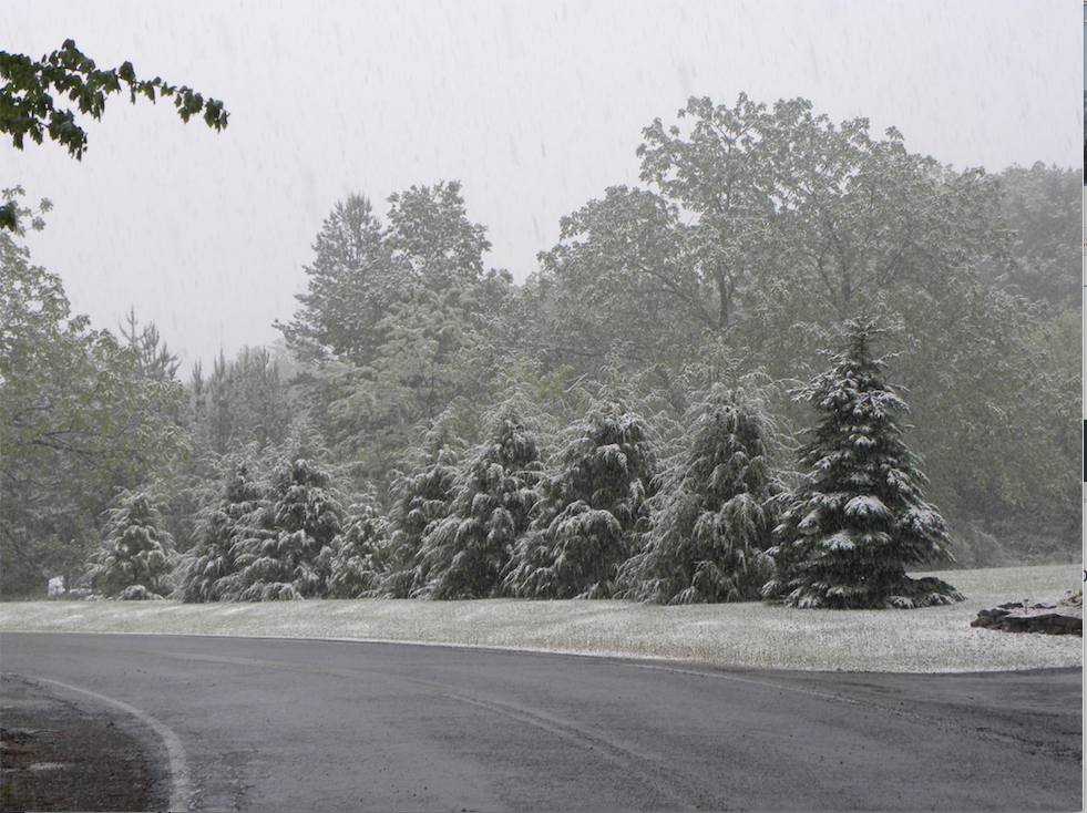
I've witnessed May snow twice and it was in a two year period... May 12, 2008 on the heels of a very deep coastal low and also May 11, 2010, the latter of which I have pictures of. It can and does happen. The pic was taken at a place that was about 1700' elevation.
-
I said back on Tuesday last week I was concerned with the pattern and late freeze potential during the first half of May in terms of gardening/farming. If you have a reasonable way to protect your garden (like covering plants), I'd def look into doing so.. especially the period next weekend thru likely several days beyond that where low temps below freezing look like a strong likelihood at least a time or two.
-
Yea that's what I would have figured, I didn't know they could switch to a different mode for that.
-
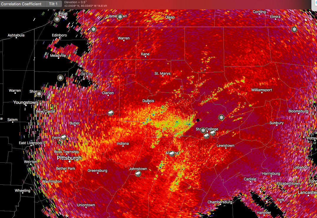
One thing I noticed while the rainstorm was unfolding yesterday was the doppler estimates definitely seemed to be low-balling what the ground observations were, which might have been a result of the raindrops themselves. The high PWAT's and deep southerly flow likely yielded efficient rainfall, but small droplets with the absence of much of a convective element that would have had the downpours with the large droplets. I only had around an inch or so back this way, but the majority of the event was the fine raindrops. If that was how the heavier rain was over in the Sus Valley, sometimes the doppler can low ball that. Especially over there where the radar beam is higher up.
-
Looks like they ended up strictly using those health regions to determine that, despite a lot of push for not strictly using the regions as a whole and allowing individual counties that meet the criteria to open up. The south-central region in particular really displays the flaw in this. It really screws this area where my home county (Blair) as well as Bedford, Huntingdon, and Fulton have been nowhere near that 50 cases per 100000 in two weeks threshold and don't even have 100 total cases between the 4 counties (88) and we get lumped in with York, Dauphin and Lebanon that have over 1800 cases between those counties. And Centre just to the north which is directly connected to Bedford and Blair via I-99 has 90 cases in that county and they are lumped with the north-central region so they'll be able to start reopening. I def don't agree with that health region approach. They issued the stay-at-home orders on a county by county approach when this started so why not now trying to ease restrictions.
-
Haha this storm looks more like the type of system that causes the big flood after the one that has the 1040 high and buries us with snow.
-
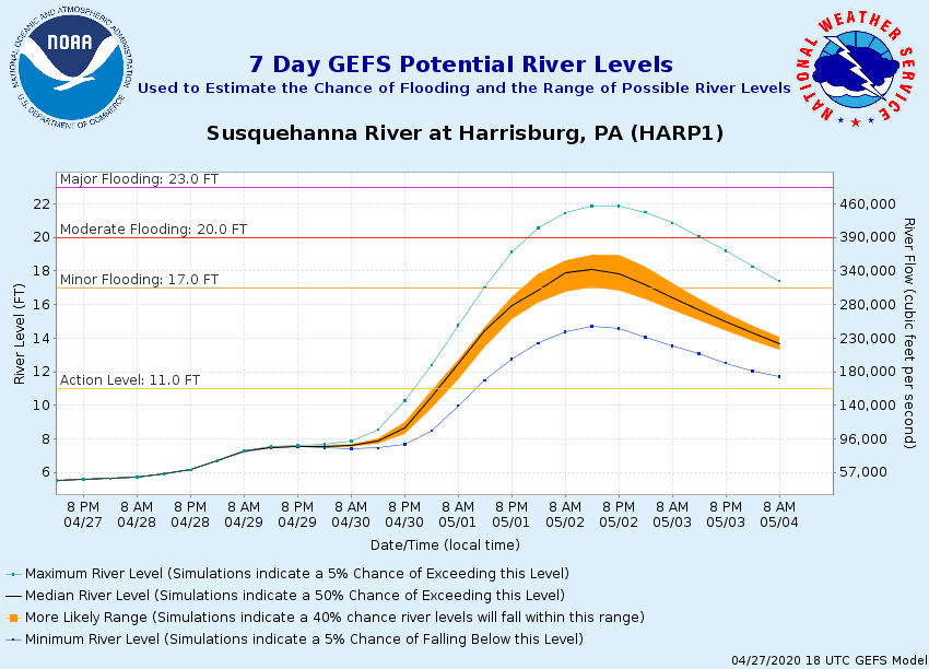
Seems like the best plume of precip is residing up I-81 to H-burg and then up the river to IPT currently. That's coinciding with main part of the moisture fetch from the Gulf. This will eventually progress east across the rest of the state, where secondary wave slows the frontal passage some and is why eastern PA is under more of a flood threat this afternoon. There's another area of heavier precip in west-central PA as well, which may consolidate some with the other area later on today in eastern PA as the front slows down. I had been thinking this event as a 3-6 hour period of the heavier rain within the overall event.. which is the key to if any flooding ends up occurring. The flood threat is looking more on the minor end with the poor drainage and smaller waterways, although the Main Susquehanna should at least see a pretty significant rise.
-
It's been the moisture more than the temps for me. It's been cool but not really too crazy temp wise here. Just the continuation of the wetter than normal conditions that have been the norm more often than not the past couple years.
-
Wed night-Thursday's system is still presenting a distinct heavy rain/flooding threat. The Euro has seemed to be the wettest/slowest operational model with this system, which is probably a fair assumption that wetter is probably the way to go given the strong southerly flow driving high PWATs and the overall pattern. NAM and GFS aren't quite as wet, and 12km NAM has a weak spot in the Sus Valley. The ensembles, GEFS/Canadian/Euro/SREF generally support the wetter Euro region wide. Still think the heavy rain portion of this event is going to come over a 3-6 hour period within the overall 18-24 hr duration of precip from later tomorrow-Thursday afternoon. That invites sharp rises on the waterways across the area as FFG is pretty low (especially in the central) and waterways are running a bit elevated. Another thing to watch is secondary development on/near the Mid-Atlantic coast, which may hang the heavy rain longer somewhere in Eastern PA. WPC has Eastern PA in a slight risk on it's excessive rainfall outlook Thursday (Day 3). GEFS guidance for the Sus River @ Harrisburg (NAEFS is similar)
-
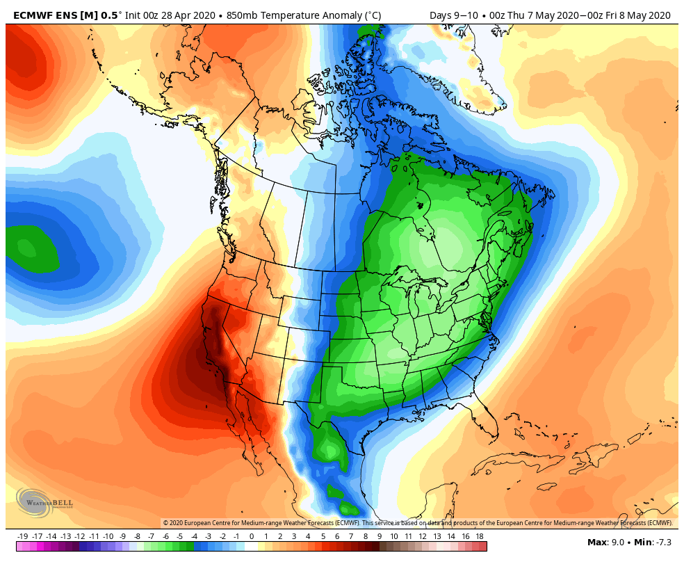
Man I don't want to be that guy, but the Euro has been doing it's best "year without a summer" impression lol. The overnight run wrecked Northern PA/Southern NY with another snowstorm (yesterday's 12z did pretty much the same thing) on May freaking 6th. This is the Euro we're talking about, and the fact that it's even showing something like this at this point in the spring season is downright remarkable. At this rate the southern tier NY/Catskills region might end up with a better "winter" MAM than DJF. There were some pretty significant snows up there from the weekend system. The weather isn't going to be wall to wall horrendous going into the first couple weeks of May, there will be nice weather and any sunny day will make things nice with the strong sun. But we're settled into an overall western ridge/eastern trough regime. Temperatures looks to remain below normal overall. The Euro is riding solo on the May 6th snowstorm but that period is showing an amplification in the eastern trough in that timeframe on modeling. 1 day average 850mb temps on 0z Euro ensemble: That's quite a solid signal for chilly weather. If I had gardening/planting/farming interests, I would be very wary of a high chance of seeing a late freeze(s) during the first half of May and be ready to deal with one. The good news in all of this? I would say by the time we transition to a warmer pattern that we'll be at a point in the spring where we won't be backtracking to weather like we're seeing now.

-
Lol, well you Sus Valley folks that felt a little left out in the QPF department yesterday should be excited for Wed-Thursday. CTP has mentioned this particular threat in the long range portion of their discussion the last couple days and seem pretty keen on an elevated flooding risk with this. Deep southerly flow ahead of this system progged for the Lakes likely imply a rain event within which a 3-6 hour period of heavy rainfall with some imbedded convection could create some issues. 3 and 6 hr FFG values are in that 2-3" range in the LSV (more like 3" in the 6hr values). They're notable lower in the western counties in the CTP region (AOO/JST) as well as the northern tier. Timing and probably track still need resolved, as corridor of heaviest precip amounts could end up being more narrow. Also fun, I just saw Pittsburgh NWS post on their Facebook that based on this weeks forecasts right now Pittsburgh, Zanesville, and Morgantown will have recorded a lower max temp in April than in January... (70/73/71) vs (71/74/74). First time that would be recorded ever in their climate records.

-
Definitely a wet/unsettled regime the next few days. That Sunday/Monday system looks like it's going to be another solid rain producer. Can't help but wonder about the what if, as the overnight models now all draw the low under PA to redevelop on the coast with a high anchored to the north. Here's hoping we're ready to rock come December, and not waste a cold pattern early during the first half of November for a change. At any rate, the potential is still there in the northern tier higher elevations of PA for a mix/changeover to snow later on in that system as the low goes to the coast.. as well as even the Laurel's on the very tail end. Pretty impressive that the prospect of such things is even on the table this late. It doesn't look like we're ready to come out of this below average/unsettled pattern through likely at least into the first week of May. When the 540 line is still clearing PA behind systems on May 1st (as in the case of the GFS), we're definitely not talking any kind of late spring/early summer warmth. Lol, or just inject a lil Lysol and it'll fix us up in no time . Nope couldn't leave that one go.
-
Definitely a slim chance of happening even in the mountains, but the only other widespread notable snowfall that's occurred this late in western/central PA was back in 1928.. so that's to be expected. For this to have a chance this advertised system will have to transfer the low to the coast, preferably early enough to get a solid Delmarva low. That's what today's 12z Euro and previous runs of either that or the GFS has done the last few days when they've occasionally had the snowfall solution. The models have a high in position to the north, but generally they're keeping a primary up into PA or the Lakes. New Canadian does have a timely transfer to the coast decently south of PA, but just a bit too warm overall with maybe high Laurel's changing over. That model had a much stronger high. Very little ensemble support right now for the wintry side. New GEFS siding generally with GFS op maintaining a dominant primary west of PA. 18z Euro ensemble showed much more signs of a decent secondary low but no snowfall. Scrutinized the Canadian a bit more, since it showed a solution that in the actual season of winter would have equaled a major snowstorm for all of C-PA. 850 temps are there, 925 and surface are not. And that illustrates why it is so hard to actually get something this late. The deep easterly fetch directly into PA on that solution would equal a pile of snow in the dead of winter, but the low level easterly flow (at 925mb to the surface) is a detriment in this case with cooling the temps enough sans significant dynamic cooling. And the solar insolation this far into spring is going to warm surface temps even with cloud cover, esp lower elevations.
-
It's a little bit confusing but I'm pretty sure these guidelines are talking about keeping a 14 day average of new cases below that 50 per 100,000 threshold. So for Cumberland County's estimated 253,370 people.. the 50 per 100,000 (0.0005) would come out to staying under 127 new cases in a 14 day period. Or in other words, they would have to average no more than about 9 new cases per day over the two weeks. Since Cumberland County as of today has only had 207 total cases for the whole span of this outbreak, you may be a lot closer to the threshold to relaxing guidelines than you think. Otherwise, how would a county whose total number of cases already exceeded infecting 50 per 100,000 people ever technically reach the guidelines to relax restrictions? PA doesn't keep track of who has recovered from this thing.
-
Lol, mangled snow flakes mixed in with this early batch of precip.
-
Back to the flakes flying around again this afternoon.
-
-
Another fairly cool and unsettled week ahead, especially the front half of the week as we drop a potent shortwave in Tuesday night and attending 510dm low centers near VT/NH/ME. Those 500mb heights are on the order of 3-4 sigma below normal for this time of the year (highly anomalous). While that 500 low centers north of here, it's still going to make for cooler than normal temps and probably more mountain snow showers Tuesday night behind the front. Extended still features a western ridge/eastern trough overall, so don't think we're going to bust into any kind of early summertime in the next couple weeks. Heck the 12z GFS wanted to do the whole northern PA snowstorm thing all over again on the 26th. It's on it's own with that, although I saw at least one run yesterday that looked like that. Moral of the story is more of the type of pattern we wanted to see in DJF lies ahead.
-
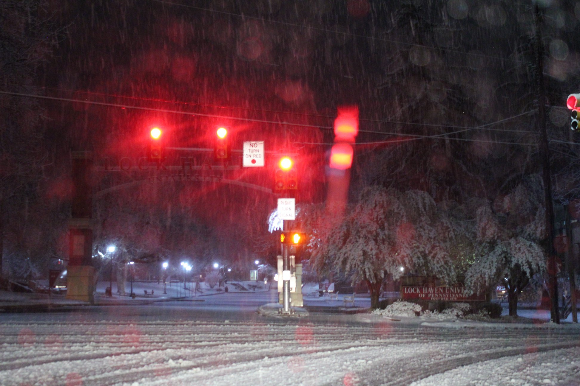
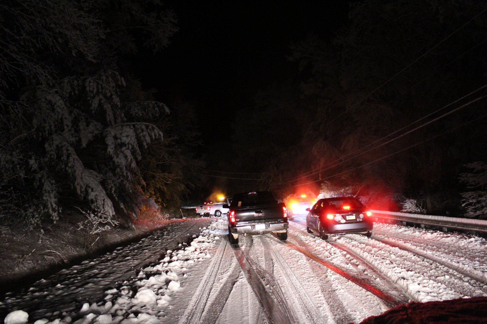
Here's some second hand pics I saw on my F-book feed out of Clinton County, likely from early tonight. First one's at LHU in Lock Haven in southern Clinton and the second one looks like Rt 120 west somewhere between Lock Haven and Renovo in the western end of the county. CTP and BGM PNS statements had some 6"+ amounts in it. The west end of State College had 2-3" and Potter and Tioga counties had a couple 5-6" reports. CTP's statement was issued just before 11pm so some of those amounts in the far northern tier probably ended up higher. Binghamton the city had a 7" report (Endicott) and 5.7" at their NWS office.


-
I had been pretty content moving on from the bad winter and looking forward to warmer spring weather but the accumulating stuff missed me here by about 20 miles today and the alternative has been 35-37ºF moderate to heavy rain all afternoon/evening. I personally would've rathered the out of season 2-5" of concrete.
-
Yea they probably should have added a tier of counties to the advisory as the I-80 corridor has been showing it on the ground all afternoon. State College had a little bit on the ground early before that heavy burst of precip moved in. PennDOT being pretty proactive and has I-80 Bellefonte to Dubois as well as I-99 from I-80 to Bellefonte under a 45mph restriction. Probably would've been a Friday evening debacle had there been regular traffic.
-
Lol that 2.25 is a bigger single snowfall than I had the entire winter. On the changeover yea the dual pol is really showing it now, and also how the UNV region is hanging on. There is actually accumulating snow starting to show on the overpasses on the I-99 cams all the way down to Port Matilda as well as a crash between Skytop and the Grays Woods exit near State College.

-
How much do you have? It looked like the top of the mountain easily had advisory amounts.