

WarmNose
-
Posts
1,125 -
Joined
-
Last visited
Content Type
Profiles
Blogs
Forums
American Weather
Media Demo
Store
Gallery
Posts posted by WarmNose
-
-
Just hit the freezing mark. Forecast low is 31. No chance
-
“If only it were January”
January: Rain
“if only we could get one of those 1040+ HP’s”
1040+HP: Rain
i think it’s best we just quit pretending we know more than we really do about the weather. There is no recipe for success when it comes to weather, only snow and rain. Success and failure. And we fail more times than not
-
 1
1
-
-
2 minutes ago, nrgjeff said:
Blue Ridge east of Cherokee gets it, and blanks Cherokee. Still we do not promise safe driving over mountains. 441 will be a mess at highest elevations.
441 was closed for several days after the early December storm. I traveled to Gatlinburg via 441 a week after the storm hit and Newfound Gap still had snow/ice on the road. It’s a whole different world up there
-
 1
1
-
-
2 minutes ago, anotherman said:
What about a resurrected DGEX?
Yeah maybe if that happened us guys down in upstate SC would have something to track besides 33 degree rain
-
28 minutes ago, AfewUniversesBelowNormal said:
00z will probably trend better.
Who are you and where is Chuck?
-
5
-
-
6 minutes ago, Iceagewhereartthou said:
It's been a couple days, the sitting water in my yard is gone and now it's just muddy. Definitely don't want to get too dry, gotta make sure those skeeters have plenty of breeding places.
My standing water is riddled with mosquitos and bullfrogs

-
46 minutes ago, Orangeburgwx said:
.7" is my yearly winter climo... Anything over that im happy
Well you already got flurries this winter so you should be near that
-
Y’all go ahead and reel this one in. It’s a stepdown process. Where’s Chuck with that 84hr NAM? Still showing some blocking?
-
18 minutes ago, AfewUniversesBelowNormal said:
The trend continues.. more -NAO on the NAM 84hr than GFS. If the NAO goes negative in the medium range, it would be a whole different mid/late January I think.
Chuck’s on board. All it took was the 84 hour NAM
-
1
-
6
-
-
6 minutes ago, andyhb said:
That is not a +PNA.
Semantics. Still looks pretty solid
-
1 hour ago, NorthArlington101 said:
OKC is getting slammed. Crazy radar.
Sister in law lives out there. She sent a video and they were getting raked. She said they were right around 6”
-
Well, 00z GFS was a bad start. You can stick a fork in 2019 if that look tries to verify. Shut the ski slopes down too. Pitiful
-
00z GFS says “good luck getting that cold out of Canada”..Ensembles will save us
-
2 hours ago, Waiting on snow said:
As always. Pattern flip will come mid March.
09’ redux? Sign me up!
-
I’m going to go ahead and drop some chlorine in the pool skimmer tomorrow afternoon. Won’t be long and I want it to be ready. The birds are on the move and the pollen won’t be far behind.
-
1
-
-
Just now, Bob Chill said:
Go back to the gefs on the 25-26th and look at day 9-15 then compare to verification. I dont trust the gefs past day 7 right now. Eps could be wrong but its been winning the pac model war lately.
Bingo. The GEFS can’t hold a look for 6 hours. I’ll bank with the Euro for now even though I am admittedly buying what the GEFS is selling. The pattern evolution is pretty evident. When/whether it translates downstream or not is still to be determined
-
Now JB is using 1984 as a stratwarm analog..I still think we get a storm in the first 1/3rd of February but this is just tiresome. Time to abandon ship for a while
-
32 minutes ago, Iceagewhereartthou said:
It's good to be north of I-40! I40 - I85; here's a tease. Everybody else; sorry Charlie

I honestly don't know how to feel about things going forward. I think there is a lot of potential, but I am concerned about the lack of true cold so far, not just around here, but nationwide. Despite the early signs of blocking we still don't seem to be able to get that in winter, and it's frustrating we're already playing the SSW card in hopes of getting some to come our way. The only thing that seems to be working out is the (endless) rainfall, but we need the cold. When I say we, I mean everybody outside of NC that got burried a couple of weeks ago and have gotten in on several small events already. I said before I fear this is going to be an I-40 /north or even state line/north winter, despite all the positive factors leading in, and that fear has not abated.
I’m picking up what you’re putting down. It’s been one heathy rain event after another. I’m not so sure these types of juicy (Niño) waves will be able to produce around here. We definitely need something flat. Every rain event here in the past several months has been 2”+ storm rainfall amounts. Blocking will be crucial as well as stout HP’s dropping into the plains to keep our southern waves from exploding. Much like our early December event (except with BLOCKING). It’s never easy getting a big dog around here and I don’t think this year will be any different, but I am hopeful. Euro weeklies looked
 If I was in the MA it would be hard to contain my excitement
-
1
-
-
48 minutes ago, nflwxman said:
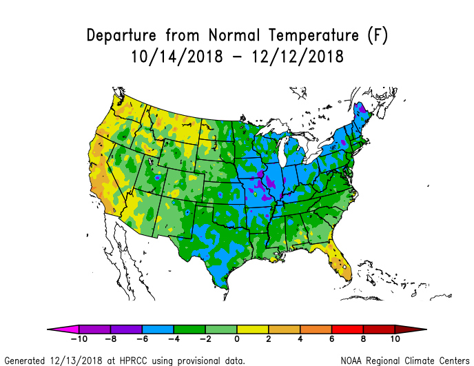
Thanks for placing a map of less than 2% of the Earth's area in the Global Temperature thread. Super duper helpful.
Says the camp who blames man when a hurricane hits a teeny tiny little piece of the US. Super duper helpful
-
1
-
-
I see the heat mongering has been tempered here in the past few weeks. I’ll just leave this here
-
1
-
-
While It sucks being just south of 85 in the upstate, we do at least get a couple inches when places throughout NC get absolutely smoked. It could be worse. A little further to my south is Greenwood SC and their climo is probably as bad or worse than Miami Florida
-
1
-
 1
1
-
-
I’ll be in Maggie Valley this weekend. Is there an outside chance at some snow showers on the backend Saturday? Not sure how these things usually play out in the high country. Very borderline. Looks like rain to me. Maybe someone can chime in
-
2 hours ago, cbmclean said:
Since we have been focused on the storm over here I have been hanging out in the MA forum for mid/long range discussion. According to Bob Chill and PSUHoffman At least most of the next two weeks should be mild across NA due to zonal flow due to the dreaded Alaska trough. After that the trough should retrograde and there we will come to a fork in the rode: An EPO trough will develop somewhere in the CONUS. If it goes east then cold in combo with the typical nino STJ could make life good.
If it goes out west though...
Models have been trying to kill that western ridge for over a month. It never disappears for more than a couple days. We may hit some transient mild periods but I see no major torch in the near future
-
18 minutes ago, CAD_Wedge_NC said:
What are you talking about???
The higher the snowpack, the warmer it gets? Sounds like a reach
January 12-13th Winter Storm Obs
in Southeastern States
Posted
I think my wet bulb is around 32.9 right now. What are your thoughts on areas just south of 85 in Greenville county? Don’t see much wiggle room