

WarmNose
-
Posts
1,125 -
Joined
-
Last visited
Content Type
Profiles
Blogs
Forums
American Weather
Media Demo
Store
Gallery
Posts posted by WarmNose
-
-
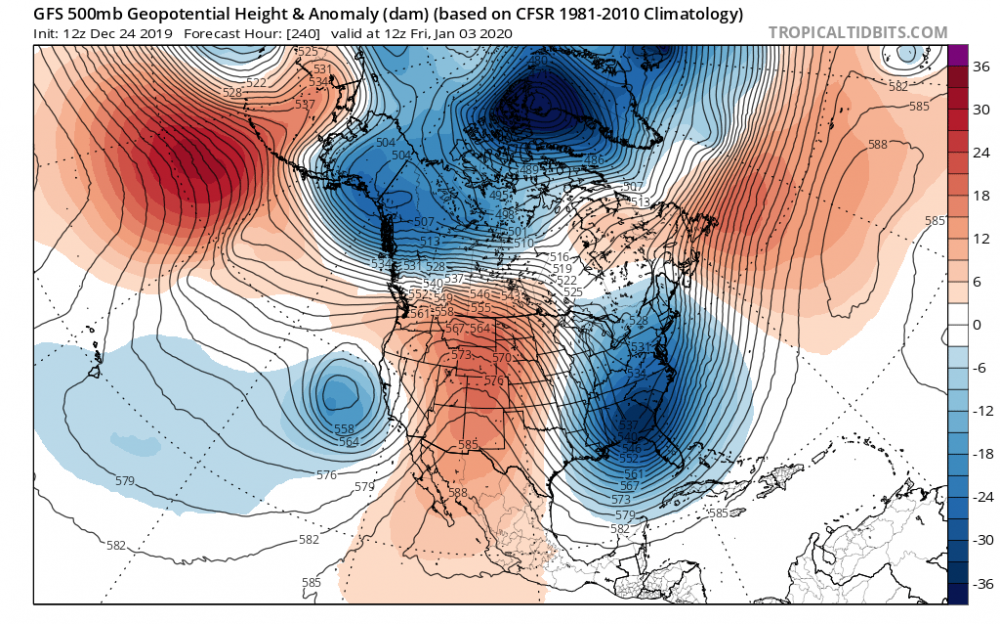
Oof. And it’s just getting started

-
Yowzer! The return of the Arctic. What a vortex this is forecasted to be
-
2 hours ago, BooneWX said:
For the love of god please tell me the cycle ends at some point.
The arctic is going to be healthy come early spring. This vortex is going to be nearly impossible to dislodge for some time. It’s hard to build heights where we need them with that anonymously strong vortex building at the pole. A -NAO will pop in early spring but by then it will be too late.
-
 1
1
-
-
Rain. And lots of it
-
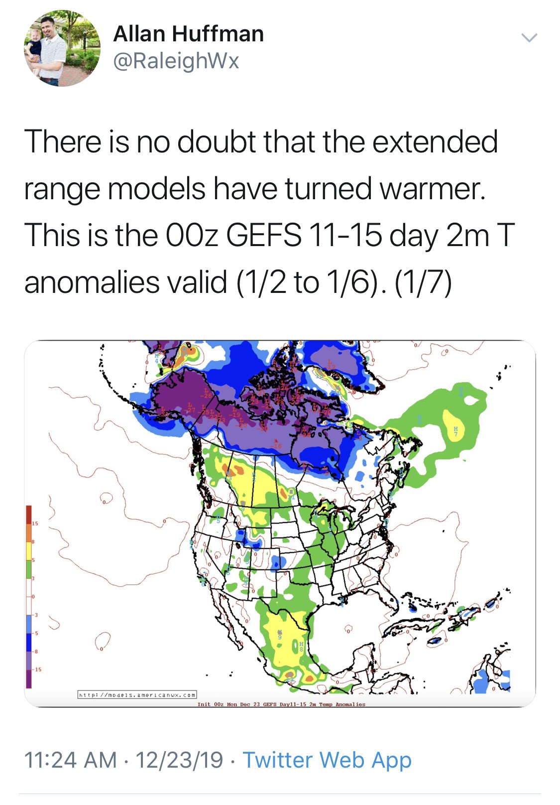
Bigly cold bottled at the pole. Thats something models can agree on. Where does it go from there? That’s the million dollar question. One had to hope
-
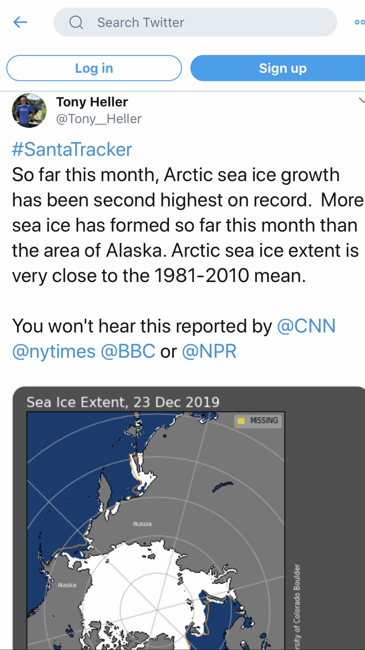
Curious to see where this leads. Looks like a major arctic ice addition is in the cards for the end of the year. Healthy PV

-
I’m just glad the server works here
-
16 minutes ago, Cold Rain said:
I don't recall December really looking all that great, though. There have been a few windows where a well-timed, perfectly executed winter storm could have happened for parts of the area. But we have not been anywhere close to a legitimate winter storm pattern, outside of a few LR model panels, which hopefully we all know by now, we shouldn't get too excited about.
Here's what I don't get. I can't understand it. I've asked before, and nobody ever really answers it. Do we really not expect to see mild periods in winter? It is the SE. It's going to be mild some of the time. We just have to hope the pattern (which you cannot determine from one LR GFS panel or one ensemble plot) isn't a dumpster fire. The predicted state of the atmosphere in a couple of weeks isn't showing signs of being a dumpster fire. That seems like a good thing to me.
I'm not saying to get overly excited about a modeled 10+ day pattern. But by the same token, there's even less of a reason to be overly pessimistic about it right now. There is no rational reason, steeped in meteorology that would lead you to conclude we're headed toward unending warmth for the winter. The only reason somebody would believe that is simply because they just want to.
At the same time, there's no rule that says you have to be excited about a week two pattern either. I don't know why it's so hard to be neutral and approach the thinking and discussion by minimizing bias and maximizing critical thinking. If you do both of those things, there is real actual reason to be somewhat more optimistic than pessimistic regarding the extended range. That's just the way things are lined out right now. Maybe that changes in a few days. But now you are just guessing/wishcasting/bittercasting or whatever term you want to use.
I think my rebuttal to that argument, just for arguments sake, is that our terrible last two winters have been salvaged by an early December miracle and that miracle didn’t happen for a 3rd straight year. Did we miss our opportunity? If we can’t manage a winter storm inside a winter month this year, like we couldn’t the last 2 years, then we get blanked. There’s reason for pessimism but deep down you have to think we can’t suck forever, right?
-
1
-
-
The last several runs of the GEFS/EPS are a total dumpster fire in the medium and extended. I believe it gets worse before it gets better
-
2
-
-
Beech mountain webcam looks like zero visibility
-
Just looking at slope cams, it looks like Beech and Sugar are running those snow guns full throttle. Should be a great head start on the ski season
-
1
-
-
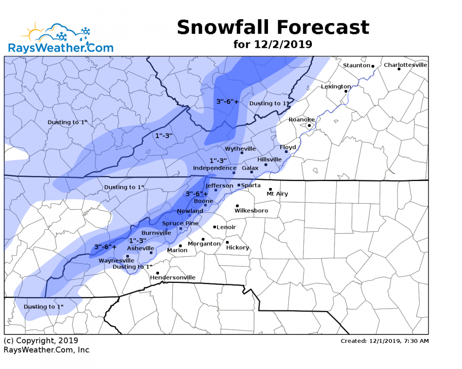
I’d imagine this ends up pretty close to reality
-
1
-
-
Pleasant fall breeze tonight. Shouldn’t be long before those southwesterly’s roll in for the duration of winter..
-
2 minutes ago, mackerel_sky said:
Sunny and dry in Simpsonville! Fitting end to a craptastic winter! Not a flurry or sprinkle
Light snow was reported here this morning. I woke up at 6am and saw the heavy precip setting up on a line from Greenwood to Rock Hill so I went back to sleep. Next
-
 1
1
-
-
It’s hilarious the snow goobers evacuate the thread for the main winter months but are back in April for one last rug pull

-
1
-
-
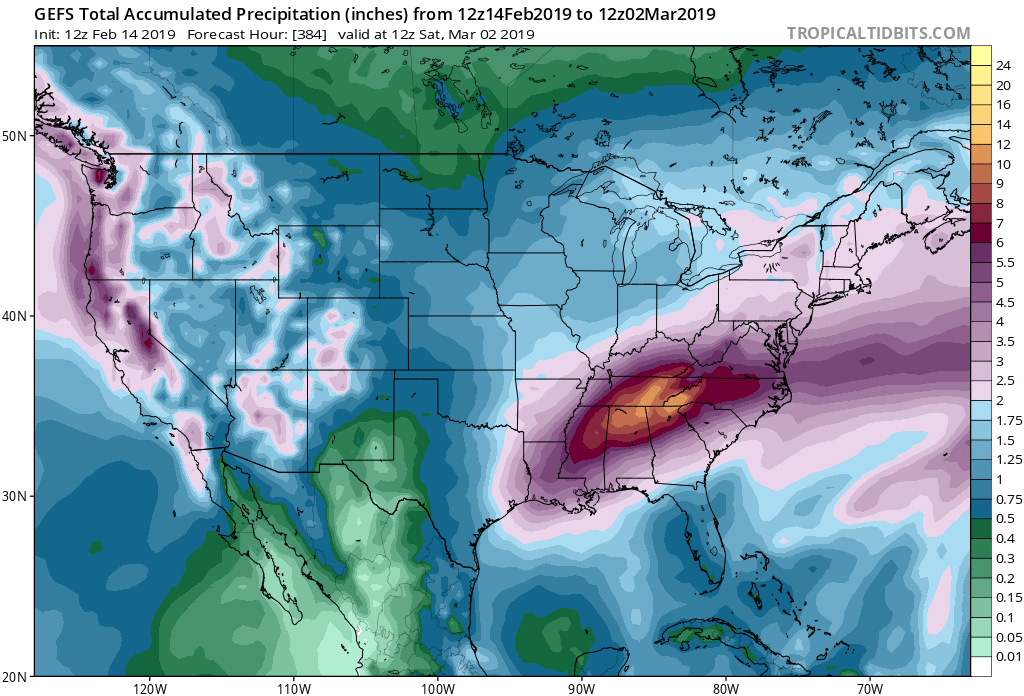
3 hours ago, mackerel_sky said:
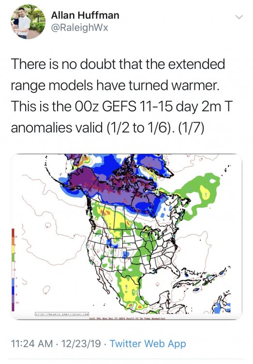
Looks like the whole winter summed up in 2 maps!

Yeah as long as you put a little blue dot over Seattle

-
Cape Cod is 100% cold rain this run. Ouch. Man I wouldn’t want to be on the fringe of this thing. The north trend has been something to behold this year
-
Snow means don’t verify but I bet rain means do

-
2
-
-
7 minutes ago, airborneheel said:
Good God. Can you imagine 37 inches in Alabama?
Not a snowball’s chance in hell. Wish I could add more. SER will win out. No way the cold push even makes it to Alabama imo
-
2
-
-
Hard to believe anything the GEFS does good in the long range (I.e Snowfall Maps) simply because it’s so block happy and it never materializes
-
Worst winter ever. I’ve seen some bad ones, but this takes the cake. Its hot today even by spring standards. We suck at snow. It will never snow again. The sky is falling. Magnetic north is shifting the wrong direction. We might as well live in South Florida. Winter is gone and never coming back
-
1
-
-
What if the FV3 beats the odds and ends up right with a CAD storm only to have other guidance converge with only a couple days left before IceMageddon? Looks like Canadian Ensembles as well as GEFS increased on their Ice potential at 12z..been a boring winter. At least this is fun again for another 4-5 hours
-
 1
1
-
-
FV3 brought the boom yet again. It’s mostly, if not all, ZR/IP for NC/SC but here’s just an idea of the wedge strength
-
 2
2
-
-
10 minutes ago, WeatherHawk said:
That looks like a nasty ice storm...rather pass on that one if it verifies
Need a solid ice pack with these strong transient highs. It’s the tablesetter for the Thursday storm..


Southeast Sanitarium - A Place to Vent
in Southeastern States
Posted
February will be another excuse. On to 2021. Solar minimum is looking ripe! Brazilian yearlies just ran and your going to love the projections!