

WarmNose
-
Posts
1,125 -
Joined
-
Last visited
Content Type
Profiles
Blogs
Forums
American Weather
Media Demo
Store
Gallery
Posts posted by WarmNose
-
-
17 minutes ago, griteater said:
Euro Weeklies have a chilly pattern look for January

Western ridge holding strong
-
 1
1
-
-
Brick still thinks he’s getting 6”. Jesus H

-
 1
1
-
-
Ive seen these storms set up shot with a raging sleet storm between Mauldin and Greenwood. North side of 276 in Mauldin usually sitting right on that snow transition line. All goods north from there
-
3 minutes ago, ozmaea said:
Simpsonville?
Sent from my SM-N950U using Tapatalk
yeah
-
1 minute ago, mackerel_sky said:
Nice map!
I can see Caesars head getting 12” easily! TR gets 4-6+”
How much for golden strip? Will we get 6-12 like Brick?
-
Everyone to the bow of the ship. This sucker is going down
-
1 minute ago, mackerel_sky said:
Yeah, I’m down to 12-14”, not liking the downward spiral trends!

Looking at weather.us it looks like we start as rain, we wet bulb several hours later and a raging SN/IP/ZR storm ensues. Looks like mostly IP but it’s some really heavy stuff. Epic epic sleet storm
-
 1
1
-
-
3 minutes ago, burgertime said:
Look where the red dot is

That’s a possum kingdom special. Mauldin Mauler. Nice pbp burger
-
2
-
-
8 minutes ago, Poimen said:
FV-3 through 0Z Monday.
So this goes off of soundings and not TT sfc maps im guessing?
-
Taking the family to Bryson City to ride the Polar Express 2 weekends from now. Bought tickets months ago. It’s safe to say dad did a good job of scheduling that one
-
1
-
-
6 minutes ago, Regan said:
Wow. Not as conservative as I was expecting. Brad Ps 1st call map.
Can we trade Chris Justus for Brad P? I understand why CJ goes with the “North of 85” call. He’s been burnt a lot already and he’s a young guy
-
1
-
-
NAM was about to go to town at the end of that run. Deep entrenched wedge. DP’s looked fantastic
-
 1
1
-
-
Hugging the Ukie south of 85 here in the upstate. Euro should come in similar. I’m a glutton for punishment
-
1
-
-
6 minutes ago, Touchet said:
Anyone worried about the NW trend?
Why would I worry about the NW trend when models are already giving me rain..? I am at peace
-
2
-
2
-
-
Looks like the timing was off with the Icon. Strong high pressure. Slow moving east though
-
4 minutes ago, jjwxman said:
Like this? 12z NAM:

Wow. South VA dp’s in the low teens..looks good to me
-
1
-
-
8 minutes ago, mackerel_sky said:
Quote of the day “ once models go warm, they don’t come back!”
Our wave isn’t been properly sampled yet..
-
 1
1
-
-
24 minutes ago, mackerel_sky said:
I’m always scared to start out as rain, but that’s a good look! How’s DPs on FV3
It’s ok. Rates will overcome
-
Bad start at 12z with the ICON. Low track still looked good to me but it blew up and cold air was absent
-
LP trended a tick stronger for tonight’s 00z runs. Not what we want. FV3 worked out for a lot of us but it wasn’t pretty. See if Euro follows suit
-
FV3 stuck at 120. Low hanging out in Mexico is a tick stronger than 18z. Hopefully a stronger LP isn’t the trend tonight..
-
S/w entering CA. Similar to Christmas 2010? Was just going back looking at some old threads. Forgot how much hell yall gave cold rain for starting an early thread. Vintage nugget
-
4
-
-
2 minutes ago, kvegas-wx said:
With the ample HP to the north, CAD should be locked into place NW of 85. This is gonna be a snow or no event with a crazy sharp cutoff somewhere between Burlington and Durham. We've seen this movie before!
You nailed it pal. At least Travelers Rest is a short drive for my little family
-
9 minutes ago, JoshM said:
Yes... I saw that, but it's still hard to believe, those amounts.
Yeah, that’s a lot of ice. The upstate had a couple barn burners back in the early 2000’s that we haven’t been able to replicate. I was always under the impression that you wanted to be somewhere in the mid to upper 20’s to maximize ice accretion. I guess everything hinges on rates since ZR is a ‘self limiting’ process. I’d take my chances 28
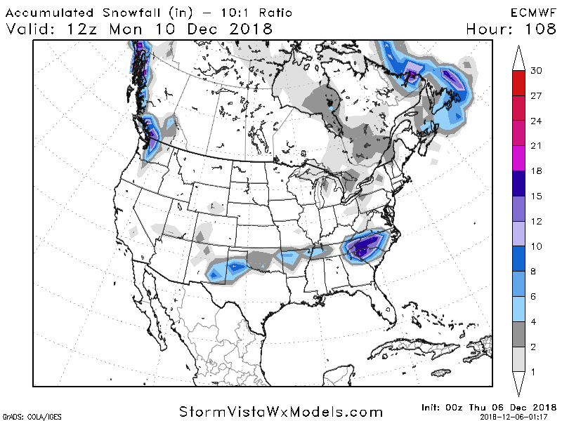
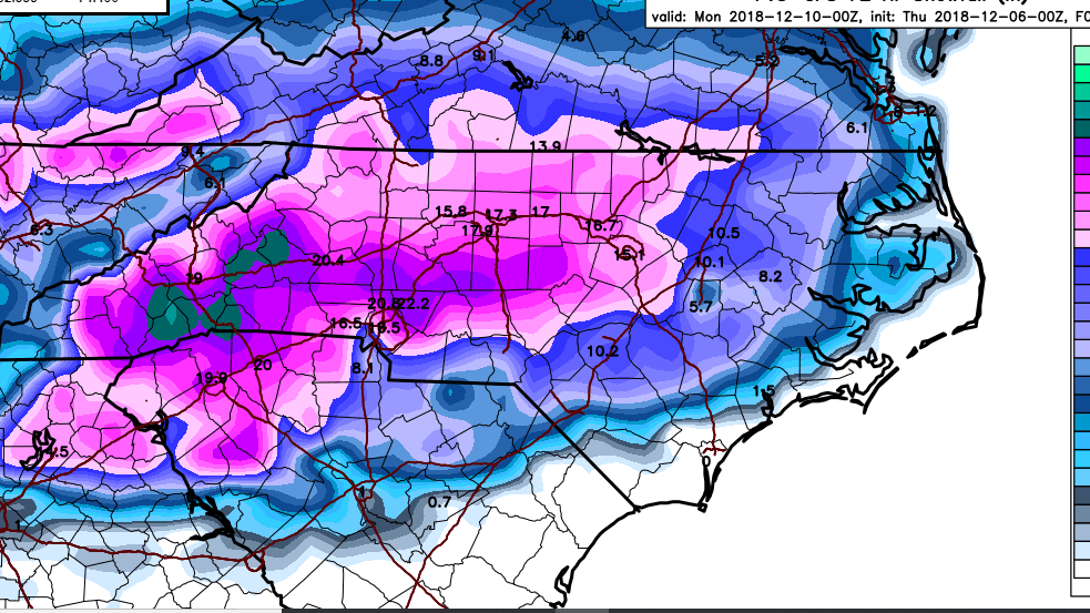
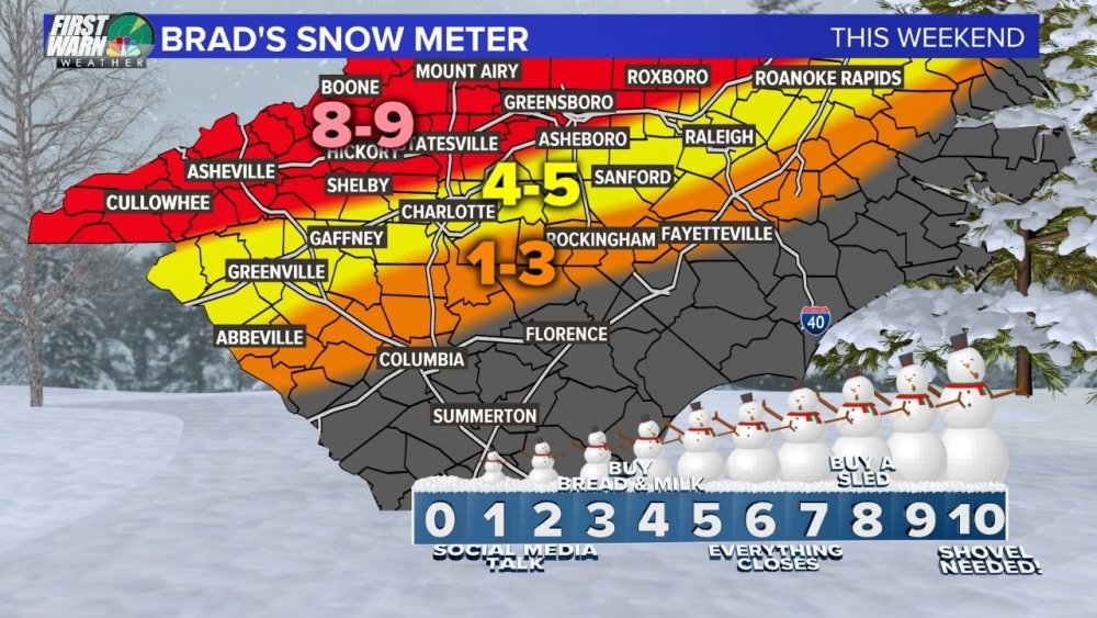
December 8-10, 2018 Winter Storm
in Southeastern States
Posted
Steady as she goes
00z December 7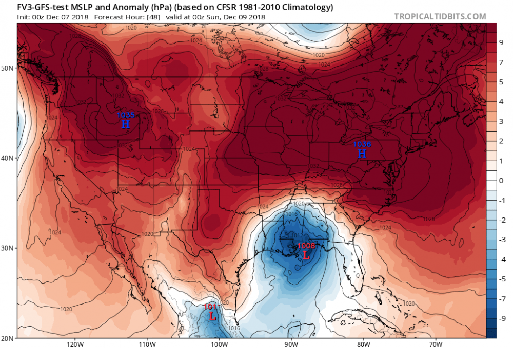
18z November 29