

WarmNose
-
Posts
1,125 -
Joined
-
Last visited
Content Type
Profiles
Blogs
Forums
American Weather
Media Demo
Store
Gallery
Posts posted by WarmNose
-
-
Last 10 days of February should offer some oppprtunity. When has a modeled raging SER been short lived? It will take a little more than half of February to chew it up and spit it out. One more shot at a Hail Mary after that. GL. May be odds be ever in your favor
-
2 minutes ago, RT1980 said:
So you’re saying that living in the SE sucks as far as snow/winter weather goes? I would have never guessed!
No. I think he’s saying this winter is exceptionally sh*tty
-
 1
1
-
 1
1
-
-
00z FV3 with another 230hr Icy hit east of the mountains. Fwiw
-
2 minutes ago, AsheCounty48 said:
FV3 has day 12 love for some, but besides that...no
It’s out there but the 12z GEFS has a stout WAR for this timeframe..
-
I keep hearing the argument that we shouldn’t give up on winter yet because it’s not even halfway over but modeling goes out to 15 days so technically it’s almost over. I know you can’t usually trust long range modeling but when it shows heat you can make an exception and count on it. With that said I still wouldn’t toss the idea of one more thread the needle event east of the mountains. Brick will probably add at least another 6” before this exhausting winter comes to s close
-
1
-
-
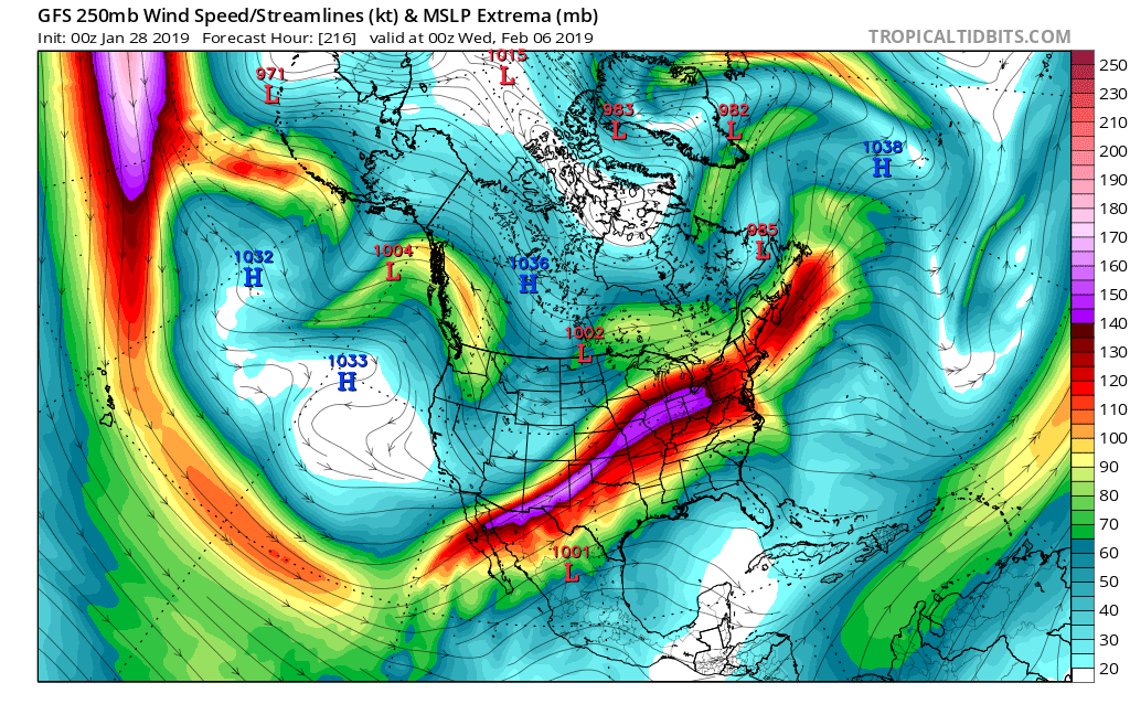
Not sure if this is a cause or a symptom but the PAC jet is screaming once again. MJO effects? I guess when we have a stout western ridge it becomes muted but without it it’s a total train wreck? Or is a screaming PAC jet what causes the ridge to break down and push eastward? Just trying to learn a little more while we have some down time in between tracking blockbuster snow storms. Thanks

-
1
-
-
Man this winter rocks! You can’t even question the Madokie Niño in the main thread without someone getting bent out of shape! There’s so much to track it’s insane. Literally haven’t slept in weeks. You can tilt your head sideways and look at 500mb maps all you want but it won’t change the fact that this winter IS and CONTINUES TO BE an epic bust. Congratulations everyone. Well done
-
1
-
-
26 minutes ago, Queencitywx said:
What happened to productive posting in the discussion thread?
It’s a valid point? Seems like we’re neutral now? My question is why was that missed? Anyway, I hate to clutter up the main thread at a time like this when there’s so much winter weather to track. Carry on
-
What happened to the MaDookie Niño I was promised? I guess those prognostications didn’t age well..
-
10 minutes ago, burrel2 said:
I'm liking the 2/1-2/2 potential. Looks like plenty of cold air available if some of the energy dropping down can amplify a little bit, at this lead time we might see some mega-hits showing up on the models soon.
One thing that looks pretty consistent on modeling is that our western ridge will break down on the heels of this “threat”. Could fit the “pattern going out” theory
-
Sorry your thread got the X, Orangeburg
im feeling pretty good about the first of February. It was a pretty good premature call imo. Also pretty good call to take it down. I’m torn
-
Grit you were right last week. I’m starting to have flashbacks of 94’ and it’s giving me the meat sweats
-
1 hour ago, Tacoma said:
Doesn't look right with snow to the south and rain to the north.
#Mountains..we’ll be lucky to get even a drop of rain from this east of the Appalachians. Focus is on the first of February which I’m giving a 1% chance for non favored areas in NC SC. Better than nothing
-
1 hour ago, JoshM said:

That’s odd. Looks eerily similar to the last dud we tracked at this range. Definitely feels like we’re stuck but it can’t not snow forever
-
1
-
-
These setups are our bread and butter here in the upstate..
 GEFS snow mean through next weekend
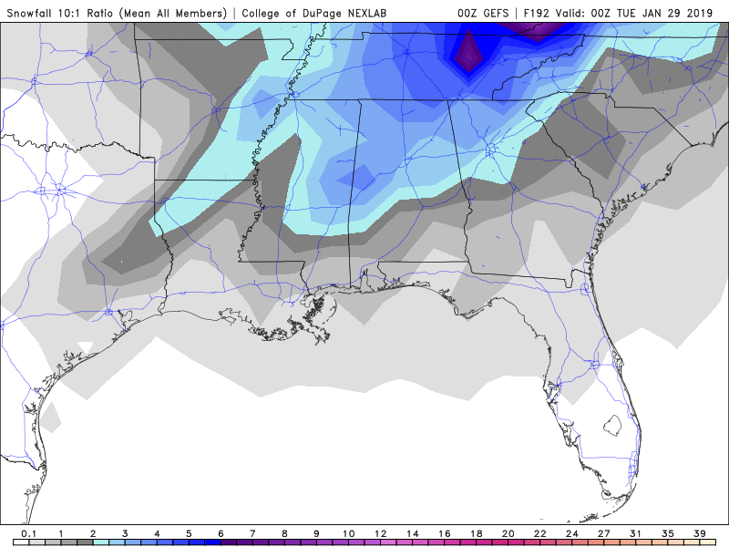
-
51 minutes ago, Queencitywx said:
This would infer to me that there is little to no ensemble support.

Still a clear signal for coastal transfer but wouldn’t look like what the operational was showing. It’s pretty clear where this thing wants to deepen right now?
-
 1
1
-
-
9 minutes ago, griteater said:
12z GFS is a clipper with light mtn snows on Sat/Sat night...night and day difference with the wave handling compared to the ICON
Night and day difference compared to its own 06z run. Ridiculous
-
7 day threats are par for the course. Lets pump the breaks before we dig this winter back out of the trashcan
-
1
-
-
9 minutes ago, yotaman said:
Speaking of cold, what would be the chances of ever seeing a cold outbreak like the one almost 34 years ago this coming weekend. http://www.markvoganweather.com/2015/12/06/a-look-back-super-arctic-outbreak-january-1985/
Florida’s citrus industry suffered $1.2 billion in losses ($2.3 billion in 2009 dollars) as a result of the inclement weather, which killed nearly every citrus tree in central Florida, and forced the industry permanently into southern Florida.
That’s a fun little factoid
-
1
-
-
1 hour ago, mackerel_sky said:
I was too busy watching the bum on Fox21 talking about lows in the low teens Monday morning and saying it’s over doing it and he’s got a low of 20
That weekend weather goober over on FoxCarolina really gets under my skin
-
 2
2
-
-
1 hour ago, Billypg70 said:
Mack you obviously didn't see John Cesarich's forecast tonight between 4-6:30
He mentions the pattern change starting Sunday.
With arctic air over the entire SE next week.
With a BAJA low entering SOCAL early next week & rolling along the Gulf Coast.
Setting the stage for a MAJOR WINTER STORM next Thursday into the weekend.
Reminds me of how Charlie Gertz called that 88 storm 2 weeks out......
Something big is on the way...
The signals are all there !
Ol’ Charlie Gertz! Drink a 5th of Vodka and nail a long range forecast live on the air
-
2
-
-
This system is barely crawling. Anybody in Tangier? Looks like it’s putting down pretty good
-
Wow. Incredible run of the GFS. We get a PV reminent in our back yard and we’re still tracking cutters
-
33 and I’m 100% sure the column is fully saturated. Pouring rain
NEXT!

Mid to Long Term Discussion 2019
in Southeastern States
Posted
18z FV3 bringing the goods to the Carolinas. Best run in quite some time