

WarmNose
-
Posts
1,125 -
Joined
-
Last visited
Content Type
Profiles
Blogs
Forums
American Weather
Media Demo
Store
Gallery
Posts posted by WarmNose
-
-
On meso models if Brick is already dealing with sleet cutting into accums in northern wake, this one is toast for the upstate. I need Brick to get 9”+ if I want more than a backend flurry

-
1 hour ago, mackerel_sky said:
It died in the main thread! Looks like Rob still going with tree crushing snows, everywhere except S.C. on his latest FB post!

I love getting sleet at 37 degrees! Roads will be a disaster down here tomorrow!

Looks like somebody hasn’t seen the WARF!

-
One bad run and we get trolled by somebody from the MA forum hugging the RGEM. Let us live

-
@mackerel_sky ok, we’ve got the Dwarf sisters and the 3k on our side now..time to head to the grocery store
-
 2
2
-
-
EPS is a total whiff-fest..report to the failboat

-
Whew..that was a knock your socks off type of run by the Euro. Talk about a pants ignition!

-
28 minutes ago, lilj4425 said:
NAM says enjoy your rain.
Don’t forget the occasional sleet pellet..this warm nose is going to mean business I’m afraid

-
43 minutes ago, buckeyefan1 said:

Even if a transfer occurs, I still expect to see a flizzard before we get slotted. It even has the possibility of being beautiful snowy slop all day with nothing accumulating, and I'll be watching it fall. #winning
I'll pout later if none of this happens

You moved to FI? I’ve lived in Fountain Inn 30+ years. If you’re hoping for enough to sled in on a late arriving cold air setup like this you’re going to be highly disappointed. Backend flurry as the coastal consolidates? Maybe
-
Just now, lilj4425 said:
KK pulled the plug two years ago.
Her forecasts don’t impress me. She’s already 0/2 this year. I’d be better off getting my weather information from a woodchuck
-
7 minutes ago, mackerel_sky said:
Meh, put the NAM in motion and it’s a rain/sleet slop, ending as flurries here! Seen it 29 times in my life! Those mountains are a b———
But we do so well when the cold arrives late.. Even if that high was 1070 we would still rain if it was west of the Apps...Cess would have pulled the plug on Friday

-
1 minute ago, Ji said:6 minutes ago, TARHEELPROGRAMMER88 said:ECMWF trended toward the CMC, but not as cold. Looks like the low is closer to the coast. Temps are an issue, as always. Good overall trends, just need a little more cold air.
Good luck with that.
Lol Ji why you up in here trolling the main disco? Get back to tracking patterns in the MA forum

-
 2
2
-
 1
1
-
-
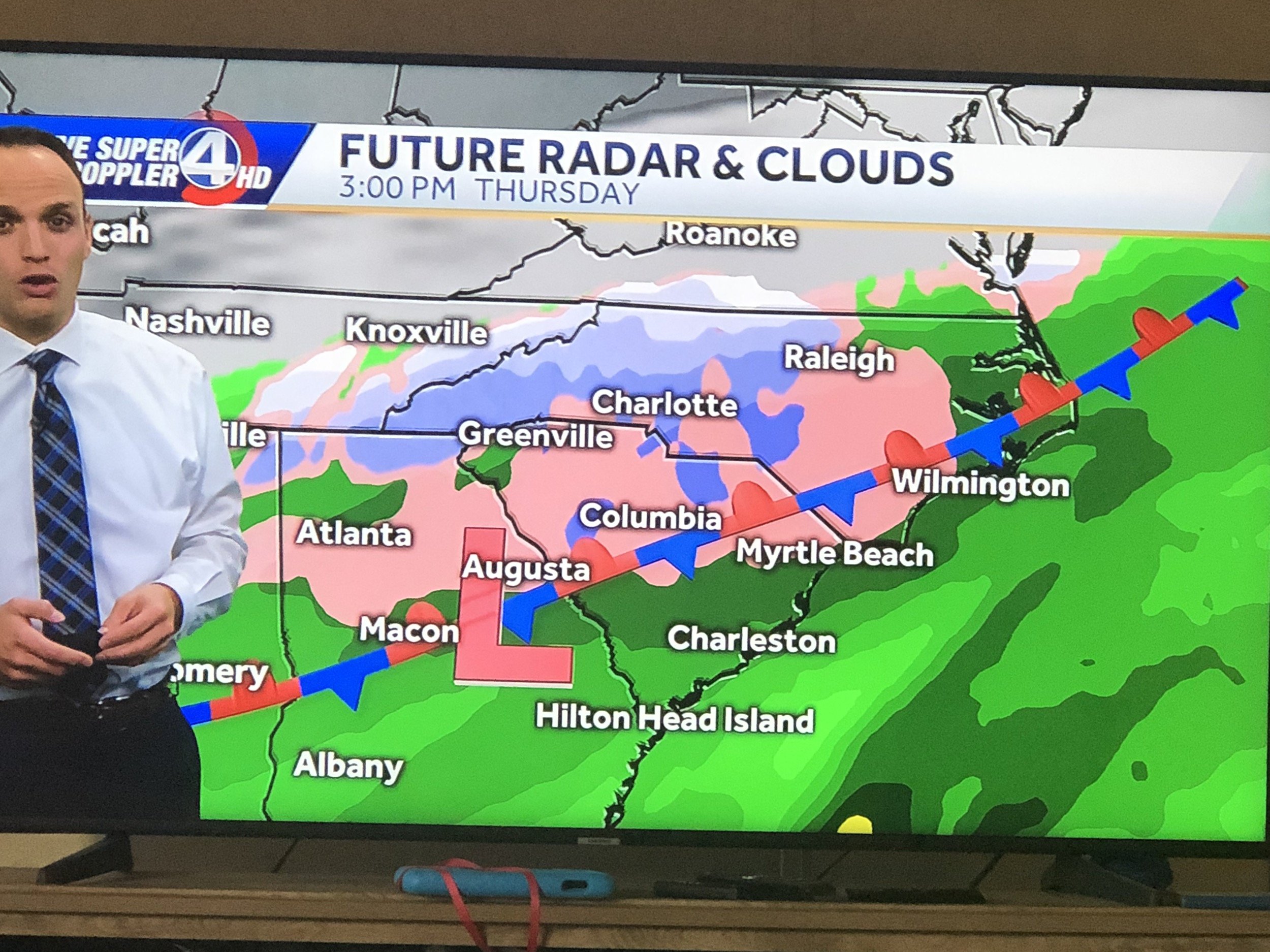
1 minute ago, Orangeburgwx said:
NAM trended colder each of the last 3 runs for 0z Thursday (which is key). Below is 12z hr84, 18z hr78, and the latest 0z hr72.


Sent from my LML212VL using Tapatalk
What am I missing? 18z looked colder than 00z
-
16 minutes ago, mackerel_sky said:
Atleast we still have the NAM and CMC on our side!

Don’t forget CJ. He’s on our side too. Deadly 3-headed combo
-
1 minute ago, mackerel_sky said:
As long as it’s cold!
Dewpoints in the single digits after all of the moisture is gone..
-
51 minutes ago, mackerel_sky said:
Yeah, I think we would need an Early Thursday start or late night Thursday start, for maximum cold availability!?
As you and I both know being on the lee side and so close the mountains, late arriving cold air is a concern. But with that said, a 1047 could do the trick. I just have my doubts for those of us who don’t benefit from late blooming coastals in a fast flow
-
15 minutes ago, griteater said:
The joys of extrapolation ha. It looked great with the storm and slower to gather out west which is good like you mentioned...but it looked like the southward push of cold air was about maxed out based on the height pattern over the southeast
Rain? Hard to fathom

-
11 minutes ago, FLweather said:


1047 dropping into the heart of the country and we’ve got rain breaking out in Arkansas. That hurts
-
Warden running a tight ship this week

-
Just now, mackerel_sky said:
I hope y’all got 2 gallons of milk and 3 loaves of bread! We gonna need it
You making bread pudding?
-
1
-
-
Don’t show Mack

-
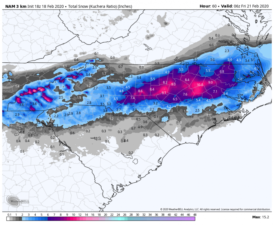
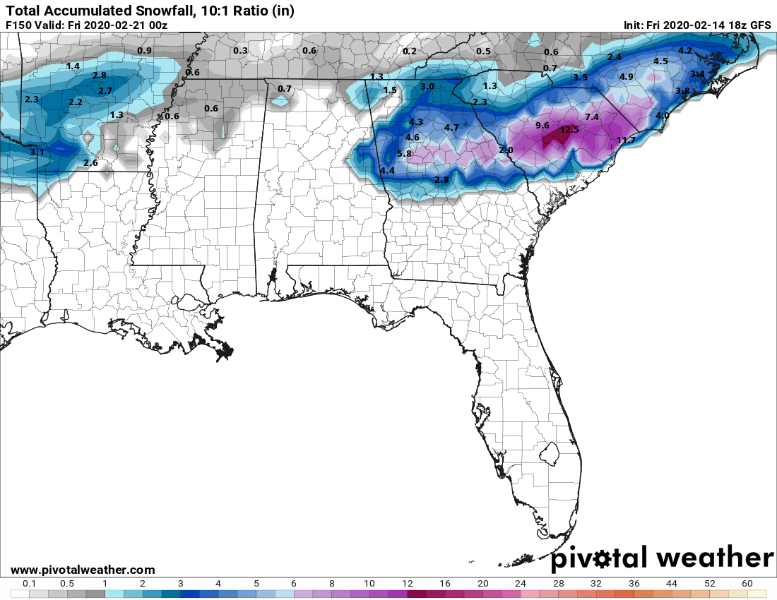
Don’t show the 18z GFS snowfall maps to Mackdaddy. A foot for Orangeburg while he gets fringed

-
@mackerel_sky this one is toast. Time to roll out the Zoysia


-
1
-
-
2 minutes ago, mackerel_sky said:
Doesn’t the GFS have a bias for holding energy back too long? I thought that was a thing? I don’t know how anything holds back in such a fast flow, just got to get timing right!
Not sure I would bet against the GFS. It nailed our last storm from 6 hours out

-
1
-
 1
1
-
-
10 minutes ago, mackerel_sky said:
When most day 10 storms have showed up this year, they were only on the GFS , the fact that the Euro has it too, is slightly a better situation
Welp, Euro now has our D10 storm in Des Moines, Iowa. We need some help


Southeast Sanitarium - A Place to Vent
in Southeastern States
Posted
Yeah. I’ll chase 2/2.5 hours to the higher elevations in Avery county for a moderate event. If I’m chasing 800+ miles I’m flying to Breckinridge