SnowDawg
-
Posts
1,253 -
Joined
-
Last visited
Content Type
Profiles
Blogs
Forums
American Weather
Media Demo
Store
Gallery
Everything posted by SnowDawg
-
Although the main run and the control are both cutters the mean is more of a coastal solution. And unsurprisingly so it's max strip of mean snowfall runs through WNC.
-
Welp...outside of the 3km NAM at long range every model has been pretty depressing tonight for North GA, that GFS run most of all.
-
I definitely think you'll see some flakes. I haven't been really sure how to feel about it all yet with how things keep jumping around. I felt pretty good for an advisory level event here in Rabun, but it's so borderline for more than that it's infuriating lol. And then the 12k NAM comes in and brings the sharp cutoff right to my doorstep and has me worried all over again.
-
Difference on the south side of the storm in North GA between the 3km and 12km is stunning.
-
Canadian cut QPF big time in WNC/Upstate/NGA same as the GFS. GFS got ensemble support for slightly weaker/dryer solution too. Wonder if the Euro comes in similar?
-
Oof...it basically cut QPF in half over Western Carolinas and N GA.
-
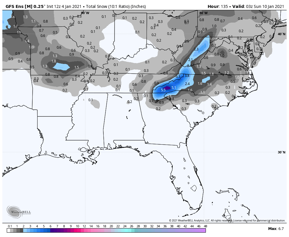
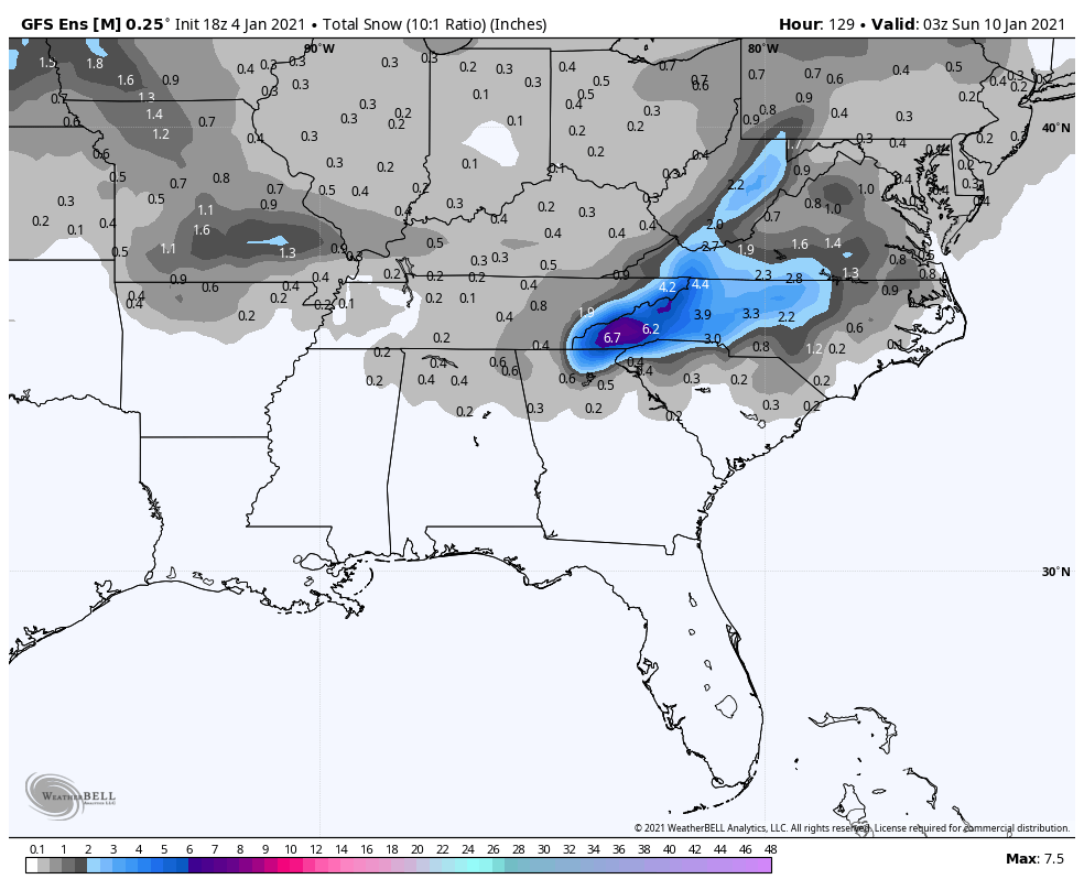
18z GEFS mean looks as good or improved for most across the board compared to 12z. 12z: 18z:

-
Oh man 6-12 County wide here in NE GA, and I thought the 12z was about as good as it could get lol. Wonder how much surface melting will be an issue or will the heavy rates be able to push the 0c thermals to the ground?
-
Oh wow that was an absolute perfect run for the N GA mountains... Heavy deformation band snow all in the overnight hours.
-
Well I'm hopeful for this one here in the NE GA mountains while atmittedly concerned about the borderline temps. I'm just happy that what comes after this over the coming weeks should only get better, and we're not staring at this marginal event as our only foreseeable hope.
-
Compared to its 18z run which was a lot better track wise, the 50/50 is way weaker on that run. We need that Thursday/Friday system to really bomb out in the 50/50 region I feel.
-
Stuck on the sleet mix line. Line will be past in the next hour. Hopefully it'll flip all snow long enough for a dusting. Flow snow usually doesn't make it here but the Hi-Res models have been ambitious.
-
Heavy mixed bag here in northeast GA. Falling sideways though in 40mph winds.
-
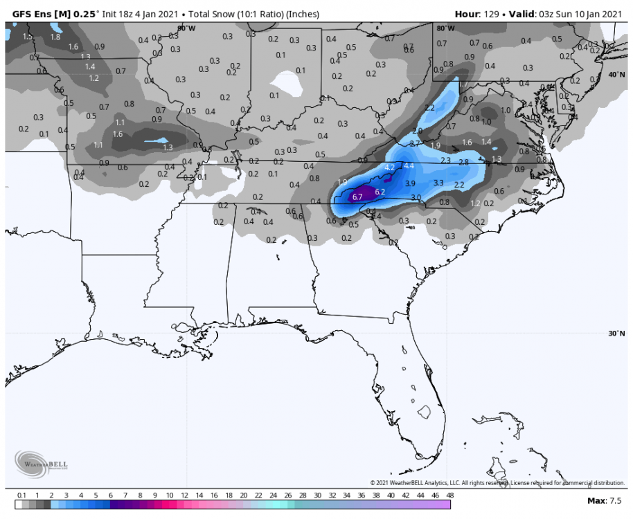
Goodness....that's 2ft plus in Central Tennessee and it's not even done lol
-
If things truly play out the way the models insist on right now, I have to question how much the NAO even means to us. EPO feels far more important at the moment. Maybe the MJO can force it to flip by early/mid January.
-
Quite the contrast with the run before it. Hopefully it's onto something with the storm track sliding south a bit.
-
Ensembles definitely the place to be for now. Swings are far less violent. GFS is whiplash inducing at the moment.
-
Going from this:to this:from just 12z to tonight is wild. Obviously still tons of big changes to come on this model. First run in like the last 8-10 that didn't have some degree of troughing over the east at this time. I vote toss lol
-
My little county here in NE GA is still at 98% without power. I don't know what all has happened to the grid, but it must be an absolute mess.
-
That's great! Better than me temps wise. Never got lower than 33 because of the warm bubble at 925. About a half inch in areas of the yard that aren't too wet. From what I've heard, Clayton itself has no accumulations.
-
Tiger, GA. In the furthest Northeast county in GA.
-
Dropped from 35 to 33 in about 30 minutes. Grassy areas now getting coated good.
-
Yep and I'm sitting right around the 925 level so my wind occasionally flips south and I get a burst of warm wind. It did drop quite a bit at my last update though so it's getting there.
-
Heaviest rates yet. 34.9 and refusing to drop, still melting on contact. Rates causing elevated surfaces to slush up a bit.
-
GFS, CMC, and Euro all agree on a ULL driven system in that same exact timeframe. Obviously a little far out but bears watching.