AMZ8990
-
Posts
1,270 -
Joined
-
Last visited
Content Type
Profiles
Blogs
Forums
American Weather
Media Demo
Store
Gallery
Everything posted by AMZ8990
-
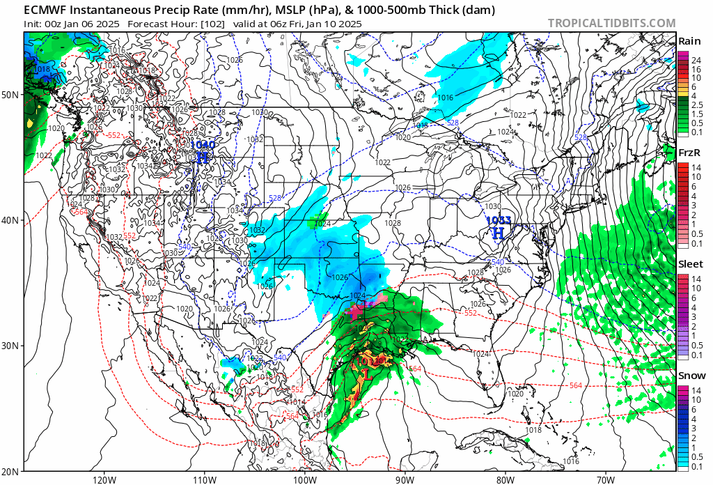
Winter storm watches now up in Texas, Oklahoma, and Arkansas.
-
Seems like model continuity/trends to a similar outcome has gotten considerably better over the last 2 days. That’s definitely a trend I like to see.
-
00z CMC onboard with the storm as well, looks like we have most of the models starting to align to a similar look/orientation.
-
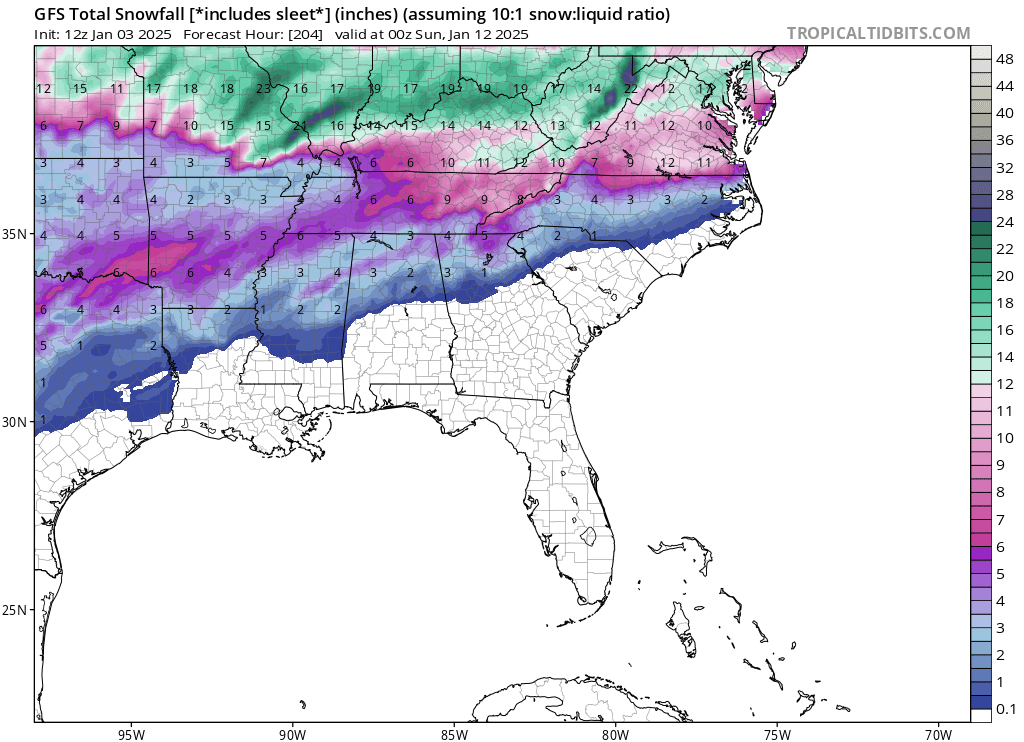
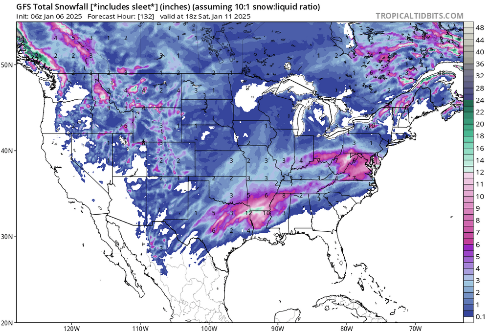
6z GFS snow totals for Friday/Saturday
-
I’ve got a good thunder and lighting show going on at the moment as this line of storms pushes through west Tn and north Ms. It’s eerily similar to the way things played out before our January snow last year.
-
Ah man, I am jealous! Enjoy your trip brother, winter park is my favorite out there. I like purgatory resort in Durango as well though.
-

-

-
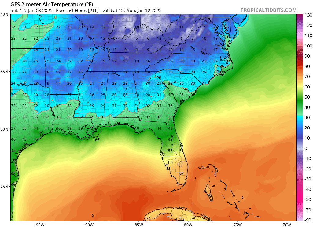
I was looking at that also, those are some big numbers for sure! I used to live just north of Cincinnati in Middletown Ohio. It Looks like they’re expecting 6-10, that drive from Louisville to Cincinnati will be treacherous. That huge decline/hill at the ky/oh border as you come into Cincy from Kentucky is going to be a problem I would think.
-
Great stuff, Holston. Thanks for sharing
-
It did, no snow in key west that run. lol. In all seriousness though a couple more ticks north and that’s a huge storm for a lot of the forum. I’m with you on the ice too, I want no part of that!
-
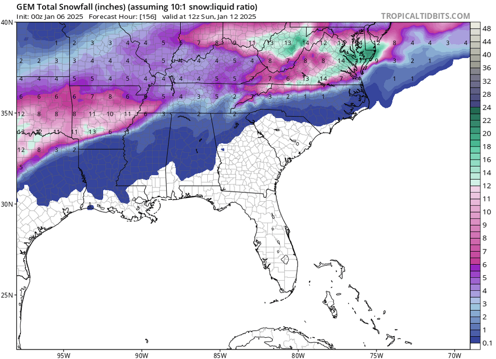
Most definitely, the strength of this cold shot is creating lots of volatility on the models from run to run. 6z GFS still wanting to take the low right through the midsouth. Big run for the Missouri/Indiana crew though. GFS is still trying to bring a 2nd system in on the 10th though, lots of potential there but HP kept it suppressed to the Deep South as it moved east.
-
Yes that is correct, from 6z Tuesday until 12z Wednesday the following week is below freezing the entire time. With wind chills included you guys would be looking at some negative temps if that were to verify.
-
I think I would toss this run of the GFS
-
Definitely seems like the Euro and GFS are on the same page about that 2nd week of January, both showing similar setups in that January 6th-10th timeframe. Long ways out but impressive to see nonetheless
-
Thanks Carv, and most definitely. I’m definitely looking forward to January and the potential we have there.
-
Winter discussion/outlook for January 2025.
-
I’ve got some Thunderstorms rolling through my area at the moment. Hopefully that’s a sign of good things to come!
-

Summer-Fall 2024 Weather Disco Med/Long Range
AMZ8990 replied to John1122's topic in Tennessee Valley
Will do- 688 replies
-
- 5
-

-

-
- heat
- thunderstorms
- (and 7 more)
-
Let the speculation begin!
-
Summer-Fall 2024 Weather Disco Med/Long Range
AMZ8990 replied to John1122's topic in Tennessee Valley
There is a growing likelihood that we could see a transition into La Niña conditions by December 2024, based on current oceanic and atmospheric data. However, there is still some uncertainty in these predictions. Climate models and meteorologists often have confidence in forecasting La Niña or El Niño conditions up to a few months in advance, but these transitions can be influenced by various factors, including the behavior of the Pacific Ocean and the atmosphere. Currently, the consensus among many forecast models suggests that La Niña conditions are more probable for the winter of 2024-2025, especially considering that ocean temperatures in the central and eastern Pacific have been showing signs of cooling. However, there is still room for uncertainty, as some models indicate the possibility of ENSO-neutral or even a delayed onset of La Niña. In short, while the chance of La Niña forming is high, the exact timing, strength, and duration remain somewhat uncertain.- 688 replies
-
- 3
-
-

-
- heat
- thunderstorms
- (and 7 more)
-
Summer-Fall 2024 Weather Disco Med/Long Range
AMZ8990 replied to John1122's topic in Tennessee Valley
The upcoming winter of 2024-2025 could share similarities with past seasons such as 1990–1991, 1993–1994, 2003–2004, 2012–2013, 2012–2014, and 2019–2020, all of which occurred during ENSO (El Niño-Southern Oscillation) neutral conditions. These years were marked by unusual weather patterns, including periods of intense cold snaps, heavy snowfall, and shifts in atmospheric pressure that affected much of the northern hemisphere. Despite the absence of a strong El Niño or La Niña event, these winters brought significant temperature fluctuations and impactful storms, often driven by other atmospheric and oceanic factors. (Blizzard of 93 for small reference). In much the same way, this winter could see similar dynamics, with rapid weather changes and extremes that challenge predictions, underscoring the unpredictability of ENSO-neutral winters when they occur.- 688 replies
-
- 3
-
-
- heat
- thunderstorms
- (and 7 more)
-
Summer-Fall 2024 Weather Disco Med/Long Range
AMZ8990 replied to John1122's topic in Tennessee Valley
Some light showers popping up along the Tn/Ms border in Memphis at the moment. We will take what we can get at this point!- 688 replies
-
- 2
-
-
- heat
- thunderstorms
- (and 7 more)
-
Summer-Fall 2024 Weather Disco Med/Long Range
AMZ8990 replied to John1122's topic in Tennessee Valley
Definitely going to be plenty of rain to go around, I think south west Tn takes the brunt of this one though. Especially Shelby county and those counties in north Mississippi along the border. It could get dangerous fast as flash flooding is probably imminent given how dry a summer we’ve had.- 688 replies
-
- 5
-
-
- heat
- thunderstorms
- (and 7 more)