

AMZ8990
-
Posts
1,270 -
Joined
-
Last visited
Content Type
Profiles
Blogs
Forums
American Weather
Media Demo
Store
Gallery
Everything posted by AMZ8990
-
-
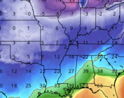
Definitely colder, at 144 those temps for our neighbors in Oklahoma and Arkansas were at a balmy 5 degrees. Low teens across the forum
-
QPF totals were insane on that UKMET run, over 2" in a lot of the forum!
-
I think the biggest positive is that we have most models on board with a winter storm for our general area. Details still need to be ironed out but the continuity is there amongst models for the most part. Nice to have something inside 7 days to track.
-
I want to say 2019 or 2020, it was 2 systems over 4 days and the first one started off as all ice and sleet then changed over to snow. That Bottom layer was 1.5” of ice with another 2” of snow on top of it, second system dropped 2.5-3” of snow with a little bit of sleet as well. Roads were frozen solid for a week straight. Kids were out of school for 8 days
-
To me It’s interesting to see all these record breaking winter storms across the world the past few weeks. Juneau Alaska had a record month for snow, we all witnessed snow train that dumped on Mammoth in cali, a once in a decade winter storm in Japan last week, places in Russia where people are tunneling out of their houses to their cars due to excessive snowfall.
-
Crazy run
-
We have plenty of potential over the coming weeks for some wintry weather. We Just have to be patient and let it all play out, I know it’s tough though! One thing I really enjoy about our forum is that we don’t have pity party’s when weather isn’t cooperating, unlike some of the other forums on this site. Collectively we have built a great community here in the Tn valley sub forum and I’m thankful for that.
-
Lock it in! That’s definitely a frame worthy model run
-
Yeah this next 5-7 days is definitely gonna be above average temp wise for a large majority of the lower 48 outside of the west coast. It could be record highs in some areas from the looks of it. As John mentioned earlier it’s gonna be another huge weekend for the snow lovers in California!! As for us in the Tennessee Valley I do think we’re headed in the right direction based off what we’re seeing in long term guidance, we’ve just gotta get through a warm week to get there!
-
That January 10th-15th 2026 timeframe is looking more and more promising. The timing of it is eerily similar to our January 9th/10th storm from earlier this year. We definitely want no part of the Ice storm its showing. As far as clown maps go that was a doozy for central Arkansas, (53 inches ZR).
-
Yeah those pictures from out west at Mammoth are insane, whoever’s skiing this weekend is getting their moneys worth!!
-

December 2025 Short/Medium Range Forecast Thread
AMZ8990 replied to John1122's topic in Tennessee Valley
URGENT - WINTER WEATHER MESSAGE National Weather Service Charleston WV 1205 AM EST Wed Dec 10 2025 WVZ522-523-526-101315- /O.CON.KRLX.BZ.W.0001.251210T1500Z-251211T1500Z/ Southeast Webster-Northwest Pocahontas-Southeast Randolph- Including the cities of Harman and Snowshoe 1205 AM EST Wed Dec 10 2025 ...BLIZZARD WARNING REMAINS IN EFFECT FROM 10 AM WEDNESDAY TO 10 AM EST THURSDAY... * WHAT...Blizzard conditions expected. Total snow accumulations between 4 and 8 inches with locally higher amounts likely. Winds gusting as high as 45 mph. * WHERE...Northwest Pocahontas, Southeast Randolph, and Southeast Webster Counties. * WHEN...From 10 AM Wednesday to 10 AM EST Thursday. * IMPACTS...Travel could be very difficult. Widespread blowing snow could significantly reduce visibility. The hazardous conditions could impact the Wednesday evening and Thursday morning commutes. Strong winds could cause tree damage. * ADDITIONAL DETAILS...An initial band of snow will move in late this morning into the early afternoon, creating blizzard conditions. There could be a break from blizzard conditions in the afternoon, before blizzard conditions set back in during the late afternoon or early evening hours. PRECAUTIONARY/PREPAREDNESS ACTIONS... Travel should be restricted to emergencies only. If you must travel, have a winter survival kit with you. If you get stranded, stay with your vehicle. The latest road conditions for the state you are calling from can be obtained by calling 5 1 1 or by accessing the online traffic and roadway portal for your state. Additional information can be found at https://www.weather.gov/rlx as well as on our X and Facebook pages. && -
December 2025 Short/Medium Range Forecast Thread
AMZ8990 replied to John1122's topic in Tennessee Valley
December is always a tough month for snow and below average temps, so I tend not to worry about the forecast too much at this point despite how disheartening it may be. Peak climatology is still ahead of us, so we have that in our favor. -
That is awesome, keep us updated. I'm loving all the OBS and pictures you all are posting!!
-
We've had a nice round of showers come through Germantown today in Memphis, picked up about 2/10 of an inch so far. It Looks like we could pick up some more throughout the evening/overnight. Were still dealing with drought conditions so every little bit helps. Temps have been in the low 70's all day
-
Hopefully today is the start of some cooler temperatures because the last week has been brutal. The Heat this past 3-5 days has been downright disrespectful!!! On a positive note, the 10-day outlook does look good with low temps in the low 60's next week and highs in the low 80's. It's almost football time in Tennessee!
-
Multiple tornadoes in Hardeman county last night, It looks like the city of Grand Junction got hit the worst though. Selmer Tennessee also had a confirmed tornado that did quite a bit of damage based off the reports I am seeing. I had 5 or 6 different tornado warnings from about 5pm to 2 am. I Will post pictures as I get them
-
Same here
-
Light to moderate sleet falling now in bolivar. 8:30 start time for event
-
Sleet reports now coming out of Collierville, tn, and in Tipton county north of Shelby county
-
You are in a great location for this storm!
-
I noticed the same thing, precipitation field is definitely ahead of schedule. Currently sitting at 40 degrees
-
RECAUTIONARY/PREPAREDNESS ACTIONS... Slow down and use caution while traveling. The latest road conditions for the state you are calling from can be obtained by calling 5 1 1. More Information ...A WINTER STORM REMAINS ON TRACK TO IMPACT THE MIDSOUTH TONIGHT... .An upper level low pressure system will interact with an approaching Arctic cold front to bring impactful snowfall to the Midsouth tonight. Snowfall of 3 to 5 inches is forecast north of Interstate 40, with highest amounts expected over far northeast Arkansas and the Missouri bootheel. South of I-40, a mixture of sleet and snow is expected this evening, with snow likely to follow overnight. Snow amounts are forecast to range from 1 to 3 inches in the Interstate 40 corridor, with lesser amounts to the south. Due to banded nature of snow, locally higher amounts of snow will be possible across the Midsouth by Wednesday morning.
-
Winter storm watch is now up for all of west Tennessee as well. Winter Storm Watch URGENT - WINTER WEATHER MESSAGE National Weather Service Memphis TN 238 PM CST Sun Feb 16 2025 ...POTENTIALLY IMPACTFUL SNOW IS POSSIBLE NORTH OF INTERSTATE 40 TUESDAY EVENING THROUGH EARLY WEDNESDAY MORNING... .A deepening upper level disturbance will move from the Great Plains to the Midsouth and Lower Ohio River Valley by Tuesday night. This feature will interact with Arctic air to bring potentially impactful snowfall along and north of Interstate 40 Tuesday night. ARZ027-035-036-TNZ049-050-052>055-088>090-171030- /O.NEW.KMEG.WS.A.0002.250218T1800Z-250219T1800Z/ Poinsett-Cross-Crittenden-Tipton-Haywood-Madison-Chester- Henderson-Decatur-Shelby-Fayette-Hardeman- Including the cities of Collierville, Millington, Bolivar, Jackson, Lexington, Parsons, Harrisburg, Covington, Bartlett, Germantown, Wynne, Decaturville, Henderson, Memphis, West Memphis, Somerville, Oakland, and Brownsville 238 PM CST Sun Feb 16 2025 ...WINTER STORM WATCH IN EFFECT FROM TUESDAY AFTERNOON THROUGH WEDNESDAY MORNING... * WHAT...Heavy wet snow possible. Total snow accumulations between 1 and 3 inches possible. * WHERE...Portions of East Arkansas and West Tennessee. * WHEN...From Tuesday afternoon through Wednesday morning. * IMPACTS...Plan on slippery road conditions. The hazardous conditions could impact the Tuesday evening and Wednesday morning commutes. PRECAUTIONARY/PREPAREDNESS ACTIONS... Monitor the latest forecasts for updates on this situation. &&


