STILL N OF PIKE
-
Posts
14,848 -
Joined
-
Last visited
Content Type
Profiles
Blogs
Forums
American Weather
Media Demo
Store
Gallery
Everything posted by STILL N OF PIKE
-
What is causing that Secondary development 12/16 system to track With such a northerly component instead of NE , the airmass would probably be just good enough if that track direction was altered
-
It seems to prevent a Torchy warm up but I think you give up a couple degrees in retrogradIng a taint (and that just doesn’t get much warmer ) 925’s
-
I was just speaking for New England
-
Exactly and the 12/12 storm retrograding further left the airmass a tad more tainted for its arrival
-
I think that set up is basically rain or snow verbatim..the Airmass is just serviceable enough for some - 850’s-925 like -1 to -3 in Montreal
-
Funky track
-
Upstate New York crushed
-
Initially the airmass is much colder post 12/12 system but then that departing low curls up and retrogrades much more and it Looks like it wraps Slightly milder air into NNE just before that 12/16 system approachEs but not sure the effect at hour 186
-
Looks good at day 12
-
Feels like Xmas eve
-
Which do you see being more likely
-
Fascinating that 11/12 -NAO December’s were dry . For Bos?
-
For the 12’th 6z GEFS May look a bit better then 0z GEFS but one problem is 0z GEFS didn’t look remotely like the 0z op storm run looking at the GEPS they didn’t seem to support the OP that well , or to put it this way the OP looks like it would have been the best ens member gonna need things to come around much more , they did move in the right direction it seems most ens guidance currently has a Low well SE of us , it’s made strides from no storm to a storm but the track on ENS needs another 100 miles NW I think
-
Just a friendly reminder If anyone has faith in the LR look of the paicific I would suggest they step away from the pipe
-
Lol I’ve been posting objectively I’m just looking for something to track that isn’t rains past Stowe VT. I don’t have a high bar My biggest concern is wether you will be able to make it to the GTG - the money line is +325, so the sharpes say no
-
Mostly frozen precip on cmc for the 15th system north of Mass border . Much better high initially and so you get redevelopment of a low earlier and further south but still some work . Low tracks from Philly to S Weymouth (more ENE / NE)
-
It’s a step in the right direction at this range and closer to something better but ya grain of salt. That was just pure commentary not excited . Maybe a whale farted and raised heights north of Hudson Bay .
-
The high pressure will be in a better position for the 0z gfs 15’th system will probably help NNE this run
-
6”+ from ORH to Jerry and Sw with West CT Jack SE of Brockton - Attleboro looks wet verbatim
-
NYC -CT crushed at hr 118-126 its wrapped up but S of pike
-
Ooo it’s juicy looking early
-
CMC is gonna do something it gets that ocean storm confluence just a tiny bit slower out of the way (than 12z) I think it’s still Good to go but further south a bit
-
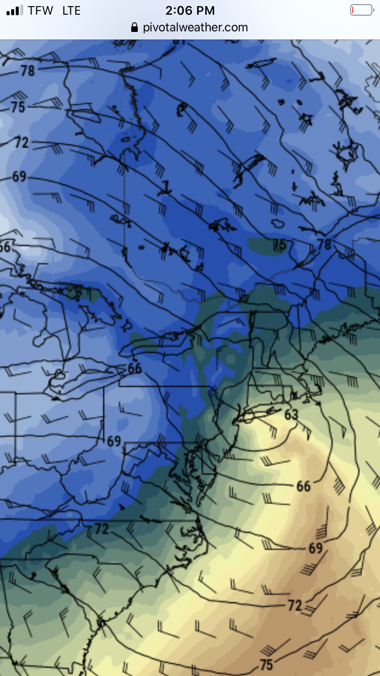
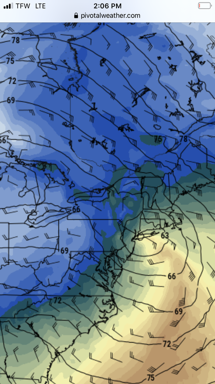
It’s advisory for central and western SNE about to the coast This run the precip sort of angled Ese so Eastern areas were relatively dry . If that energy consolidates a tad more you would see that change . Probably equal chances or better it goes poofy
-
Gfs May try for something Monday The energy has a more consolidated look than 18z , it’s not in realm of the zonked our cmc from noon but worth watching
-
Does Funky Murphys have a band Saturday . You think they will take a request