

eduggs
-
Posts
5,949 -
Joined
-
Last visited
Content Type
Profiles
Blogs
Forums
American Weather
Media Demo
Store
Gallery
Everything posted by eduggs
-
It's kind of impressive how the Euro OP manages to engineer a way to avoid snow for the next 15 days. Barely a dusting in 2+ weeks. And it has support from the other globals and ensembles. In November, sure... but early Feb?!
-
All good points. But it's difficult to force the enjoyment when we're staring at such a bleak two weeks of modeling. After mid-Feb a sunny day inevitably feels like Spring, even on a cold day.
-
It's really a shame to waste 3 weeks of peak winter climo to drought. By the time the longwave suppression eases we'll be fighting climo norms.
-
Normals at NYC on Feb 28 are 45/32. Spring is coming fast.
-
The AIGFS has 1-1.5" liquid total for its run across our region. Almost all rain
-
The GFS is bringing down the ULL at day 5 pretty far west. Could be interesting for New England days 6 and 7.
-
Close the blinds. But is it for one week or two?
-
This winter feels much better than last year. But my location hasn't been lucky snow-wise since 2021
-
The AI models have been pretty insistent that when precipitation finally returns around day 9, it's rain. I don't buy it yet because guidance has been too quick with warmups this winter. But there sure has been a lot of wasted cold this season.
-
Yeah it's up to 0.05" now in a few spots. But there has been no improvement in the height field in Ontario for several days. The RRFS dropped off at 18z. I was hoping this could trend into a 2-3" plowable event but it's settling into a C-1". And there's not much behind it. Super-suppressive northwest flow.
-
So far at 18z the models are engineering a perfectly dry week with the bowling ball ULL and a follow up shortwave traversing southern ON to NNY perfectly suppressing any storm threats.
-
Cold, windy, dry.
-
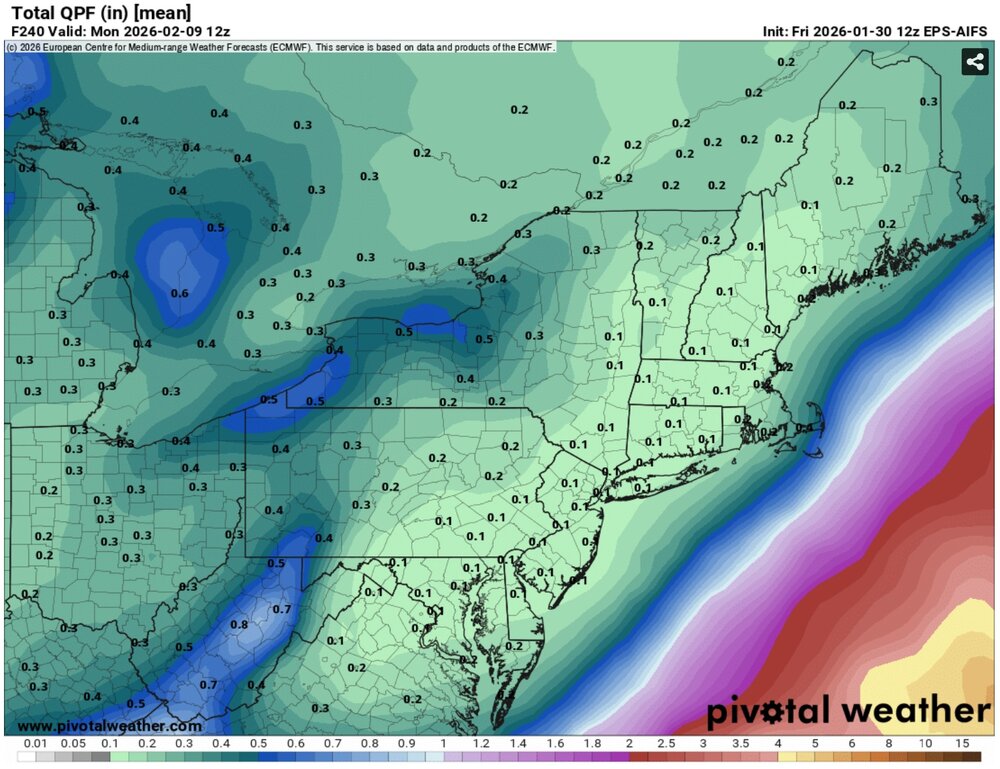
The GEFS, GEPS, EPS, ICON-EPS, EPS, GFSAI, ECMWF-AIFS and EPS-AIFS are all very dry out through 10 days. That has been the theme of this winter apart from last weekend.
-
Both the GFSAI and ECMWF-AIFS bring some rain beginning Feb 10. It's a persistent signal. No telling if it fades and/or is transient. In a few days we'll have a better idea if the cold will linger through that period.
-
The Wednesday shortwave has been ticking slightly more favorable across multiple guidance for several runs. The height field has been gaining every so slightly more meridional angle as it crosses south of us. The ULL in Ontario is a shame, but we might we able to trend this to a plowable event for some. Without that, there's nothing distinct on the horizon for a while. And spring is looming out in fantasyland.
-
GFS-AI is miss, miss, rain. GFS is miss, miss, cold. But both are close to back to back hits. With the reliability of the ECM-AIFS, which is also showing essentially a miss, miss scenario next week, that should probably be the baseline for expectations until things look more hopeful. It's definitely not a close the blinds week though, fortunately.
-
Yuck.
-
That was a brutal 12z ECM-AIFS run all the way out to 10 days. The low heights in southern Ontario are perfectly timed to squash the mid-week threat. Then it's cold northwest flow through to the extended range. The worst part about the ECM-AIFS is that it's so steady and reliable that it's ruins wishcasting
-
This deep winter feel is really enjoyable. And I'm really happy with the 10"+ of concrete I got last weekend and several hours of outdoor activities in heavy snow. But I just realized it's been 9 straight days of unfavorable weather modeling for snow locally. It began on the Thursday before the big event, and nothing has trended favorably since that day. The AI models are so steady and reliable that I start to lose confidence that something can pop up inside 7 days.
-
Currently 8" snow depth not too far from Morristown, NJ. That's probably slightly above the 30 year average for the date but not unusual. There has been good snow cover for several weeks but not a deep snow pack. Lake ice is getting really thick.
-
Let's trend the Wednesday wave north. That's the easiest way to score some snow next week. Ensembles had been improving but took a step back beginning overnight. I don't think we've had a plowable snow event this winter when the ECM-AI was not showing it 6 days out.
-
I don't like the way guidance is headed for next week. The ECM-AI looks to once again lead the way. As others have said - looks like we're headed back to a northern stream dominated period with wave interference problems. Notice how a tiny piece of energy escapes from the "southern stream" on Tuesday under the longwave trof at exactly the same time as a renegade ULL traverses southern Ontario, suppressing heights along the east coast. Cold and dry looks to reign until the drought is broken in the west. The Wed - Fri period doesn't look hopeless, but it's starting to slip away.
-
The 6z ECMWF-AIFS is pretty snowy late next week. The 12 AIGFS is very similar aloft. Pond ice is great. Winter tracking continues...
-
The 9z SREF is really juiced up. The mean is over 0.25" liquid at NYC (3z was a little less). I count 11 hits and 13 misses among the members. A few of the hits are major. This is the weeniest of weenie "models." But I still prefer seeing it increase QPF rather than decrease it run to run.
-
The ICON ensembles have about a tenth liquid back to NYC. So really just a few outlier individual members with a glancing hit. This is a little better than 6z and a little worse than 0z. Just enough interest for false hope.


