eduggs
-
Posts
5,951 -
Joined
-
Last visited
Content Type
Profiles
Blogs
Forums
American Weather
Media Demo
Store
Gallery
Everything posted by eduggs
-
The 9z SREF is really juiced up. The mean is over 0.25" liquid at NYC (3z was a little less). I count 11 hits and 13 misses among the members. A few of the hits are major. This is the weeniest of weenie "models." But I still prefer seeing it increase QPF rather than decrease it run to run.
-
The ICON ensembles have about a tenth liquid back to NYC. So really just a few outlier individual members with a glancing hit. This is a little better than 6z and a little worse than 0z. Just enough interest for false hope.
-
The RGEM run isn't encouraging. Worst run in several cycles. And the excellent run-to-run consistency dating back a few days further decreases the chances of last minute positive changes.
-
I haven't looked closely but it seemed to be incorporating very high liquid to snow ratios. The QPF forecast map doesn't look that unreasonable, especially considering the lag. NWS offices also have to account for the small possibility that this shifts back NW at the last minute. They don't want forecast whiplash.
-
If other guidance eventually matches the NAM and we get one more small tick closer, this would be a fun nowcast on Sunday for coastal regions. I'm doubtful we even get that close given the persistence of unsupportive modeling outside recent ECM runs. But it's still a low level chance IMO.
-
I'd still be keeping an eye on this if I was in eastern LI or coastal NJ - esp SNJ. Could still be a close pass with a deformation band even if the SLP is very far offshore.
-
Yeah something usually goes wrong. But I think it's always been like that to a large degree. It's why NYC rarely exceeded 80" in a winter even dating back 100+ years and during a colder climate. We just didn't used to so carefully monitor from 10 days out on a dozen different models every 6 hours. It was convoluted in the past too but we just didn't notice.
-
It seems like parts of LI have done well this winter. NJ, with the possible exception of right along the NY border, has had a lot of sleet during both bigger events. It's definitely been a much better winter than the past few with lots of minor events and one major. But out this way it still feels like we're waiting for something to break right.
-
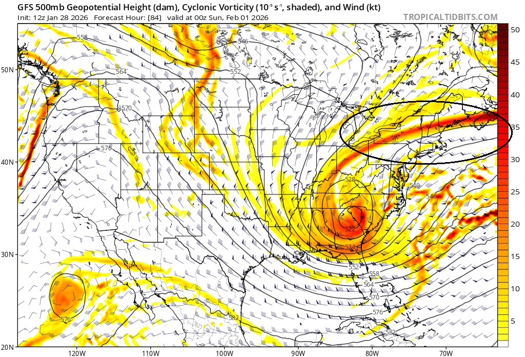
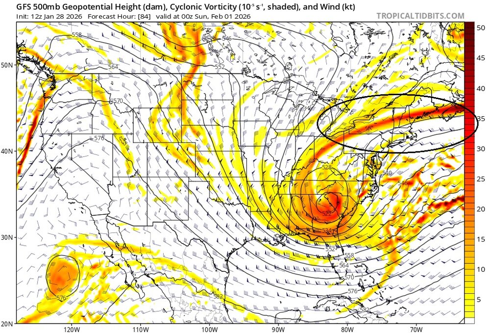
No it has nothing to do with surface features. The upper levels just aren't quite supportive of a significant coastal impact. The 500mb heights on Friday from the Atlantic south of Nova Scotia directly west to the NY/PA border are too low. There is too much suppression. That forces the ULL all the way down to Savannah Ga and there's not enough time to develop ridging in NY State and recover the baroclinic zone closer to the coast. An area of low surface pressure responds to the upper level divergence, forming and tracking well offshore.
-
This is probably one of those cases where probability of exceedance does a better job than QPF mean at characterizing the likelihood of impact. A few high QPF members are likely skewing the mean.
-
The 18z ECM was the only model for the past several days to depict the weenie mid-level fronto band displaced very far northwest of the SLP that sometimes materializes in these wrapped up ULLs. The 18z run really wrings it out in western SNE - would probably be 10" of powder back to Springfield and Hartford on that depiction. But it even affects the NYC area for several hours. We need to see the ribbon of vorticity out ahead of the ULL punch further NW into Canada to allow the cutoff more room to curl up underneath. That allows the mid-level goods to retrograde further west. Odds are against us based on minimal support even amongst ensembles. But I'll be watching that key band of vorticity as we enter the hail mary range.
-
Sometimes there is a weenie mid-level fronto band well northwest of model progs with these rapidly maturing ULLs. This band can produce as it pivots in place on rare occasions. I think this was more commonly undermodeled in the past when model resolution was much worse. That's the only morsel of hope I can think of. This one is looking pretty bleak. A big, surprise shift NW on the next NAM run would do wonders for morale. But we have no reason to think that will happen.
-
This was the chance for historic snow depths and cold. There are no obvious snow threats beyond this one on the horizon but it looks seasonably cold and northern-stream dominated. We'll probably have some snow chances in February, but the month is the beginning of melt season.
-
This ribbon of vorticity keeps trending south on all guidance even as some models continue to deepen the ULL and negatively tilt the trof axis. You need that ribbon arcing up through southern Ontario for the SLP to gain latitude. The trend is a beautiful thing for an eastern VA/NC blizzard. But it screams OTS further up the coast.
-
Measured 10" slow/sleet and then an additional 1" of sleet after clearing for a total of 11". Nice storm!
-
That's just crazy. The Euro and RGEM were showing 10+ for DCA and Philly for days. The RGEM and Euro had Morris County as all-snow for this event on their runs this morning!! It's been sleet or a mix for 9 hours!!!
-
Pivotal weather showed pink briefly up to 84. Later runs showed it further south. And I know melted flakes (indicating a warm layer) were observed in Sussex and Putnam. I'd love to see actual balloon soundings to compare to model forecast soundings. That's the only way we can really assess the model performance. Pivotal weather's ptype graphics are a bit of a black box.
-
Did you fail to notice that sleet has been mixing in since about 2pm? For the 100th time, the NAM does not explicitly forecast snow. I don't know why this is so hard to understand.
-
I think you are onto something. Sometimes all that is required is the 0.25mi vis. When it's really cold and a little windy, the visibility is often that low. Doesn't mean the intensity of the snow is actually that high. I think the very cold temperatures today has a lot to do with all the heavy snow obs... unfortunately the obs are not well correlated to actual liquid/hr.
-
Poughkeepsie with 8 consecutive heavy snow obs and counting. The preceding 3 were moderate snow with 2 at 0.25mi vis. I've never seen that before... even in 1993 and 1996.
-
I just noticed that there were 8 consecutive heavy snows obs at Sussex Airport this afternoon and evening. All at 7F. That's awesome. Doesn't happen often. 10 consecutive at Danbury, which is maybe even more impressive. Wow.
-
Similar here but it hasn't increased the total snow depth due to compaction. Keeps the roads fcked though and lots of work for the snow plow drivers.
-
OMG
-
I always love that radar view! But man... missed out on 4+ additional hours of mostly snow by about 10 miles!! What a great storm Sussex to Rockland to Westchester to Fairfield!! A few flakes finally mixing back in though after a few hours of all sleet.
-
Total pelt fest out there, wow! Just cleared a long driveway and the sleet plus windblown accumulated about 1/2" in an hour and a half. But new snow depth is still at 10". Really dense snow to move. Congrats to those north of this stuff!