

Chicago Storm
-
Posts
18,698 -
Joined
-
Last visited
Content Type
Profiles
Blogs
Forums
American Weather
Media Demo
Store
Gallery
Everything posted by Chicago Storm
-
I wouldn’t go there yet. .
-
Given how guidance has been trending, jumping from 5th to 2nd is a lock. Maybe a very outside chance of 1st still. .
-

Winter 2019-20 Medium/Long Range Discussion
Chicago Storm replied to Hoosier's topic in Lakes/Ohio Valley
. -
Winter 2019-20 Medium/Long Range Discussion
Chicago Storm replied to Hoosier's topic in Lakes/Ohio Valley
All of the so called “guru’s” have failed this far. Not saying he’s one per say, but will lump him in given he’s almost always talking cold for somewhere. . -
2019 Year in Review + Decade in Review
Chicago Storm replied to Hoosier's topic in Lakes/Ohio Valley
My top 10 events for 2019... 1. June 25th severe t'storm. Produced 2.25" hail and 50-60mph downburst winds imby. 2. April 14th snowstorm. 7.5" of snow imby, and 5.4" at ORD. 3. Halloween snowstorm. 6.5" of snow imby, 4.6" at ORD. 4. April 27th snowstorm. 5.5" of snow imby, and 2.5" at ORD. 5. February 11-12th ice storm. 0.30-0.55" ice accrual across the area, with some tree damage/power outages. 6. Late January cold. High temps in -10's and low temps in -20, with -50 WC's. 7. Christmas record warm temps. 8. Veterans Day snow event. 4.0" of snow imby, and 3.4" at ORD. 9. Post Veterans Day record November cold. 10. April 27-May 3rd heavy rain event. Area totals of 4-9" of rain, with flooding. -
61 ORD and 62 MDW today. As mentioned before, previous record for the date of 55 was easily surpassed.
-
Trees budding and flowers coming up around the area. Welcome to spring. .
-
60 at ORD as of noon. PWK torching at 62. .
-
Topped out at 61 MDW and 57 ORD today. Looks like low 60's a lock tomorrow, with the record of 55 likely being blown away.
-
Never though I'd experience a 6"+ snowstorm on Halloween, followed by 60F and shorts weather on Christmas...in the same year.
-
60 at MDW. ORD lagging at 56 though. Records broken across the state already at RFD, MLI, PIA, UIN, SPI and more. .
-
Temps might overachieve today, with less cirrus than expected. Already around 60 as far north as MLI and PNT. .
-
Winter 2019-20 Medium/Long Range Discussion
Chicago Storm replied to Hoosier's topic in Lakes/Ohio Valley
zzzzz... Edit: Should mention that since my last post last week, the GEFS caved to the EPS in showing fairly close to the same as below.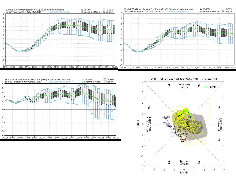
-
Winter 2019-20 Medium/Long Range Discussion
Chicago Storm replied to Hoosier's topic in Lakes/Ohio Valley
After that 1-2 run change, they reverted back. . -
Winter 2019-20 Medium/Long Range Discussion
Chicago Storm replied to Hoosier's topic in Lakes/Ohio Valley
As you could probably figure out by the current/upcoming pattern, the Euro ENS were correct in handling/depicting a +EPO...while the GFS ENS failed horribly. The bad news...If ENS have a good handle on things, that upcoming potential pattern change guidance was hinting at to end December and begin January might be in jeopardy. The Euro and GFS ENS are showing a continued +EPO continue right on into early January. On top of that, the Euro ENS also have a +AO/+NAO/neutral PNA set in as well. The GFS ENS are a bit more subdue overall, more similar to what we are seeing now. Also of note, is that some of the GFS and Euro ENS have the MJO moving from the COD on into phase 6 for the late Dec/early Jan time-frame. If that were to happen, combined with the potential teleconnections in projected, and the fact the main PV will be up over the North Pole/Siberia...things *could* get even more torchy/snow-less...and that's saying something given how the past 5 weeks have been. Not saying that will happen... But the projected teleconnections alone should be a concern that an overall mild/snow-less pattern continues into at least early January. -
Exactly what I was thinking. Definitely a positive step, but I could see how the northern zone will still be an issue at times.
-
The changes are finally coming...
-
Winter 2019-20 Medium/Long Range Discussion
Chicago Storm replied to Hoosier's topic in Lakes/Ohio Valley
The "people" have been wrong so far. So I wouldn't put too much stock into what they say. However on the flip side, it does appear there is support for the potential of a more favorable pattern for cold/snow around or after the New Year. The GFS ENS are more gung-ho on this than the Euro ENS though. -
Winter 2019-20 Medium/Long Range Discussion
Chicago Storm replied to Hoosier's topic in Lakes/Ohio Valley
Equal chances either way that far out. However, it is sort of interesting at the same time that there is not even a long range fantasy storm heading into January. -
Winter 2019-20 Medium/Long Range Discussion
Chicago Storm replied to Hoosier's topic in Lakes/Ohio Valley
A lot of valid questions/possibilities. -
Winter 2019-20 Medium/Long Range Discussion
Chicago Storm replied to Hoosier's topic in Lakes/Ohio Valley
You know it’s bad when the GFS doesn’t even have a fantasy snowstorm the entire run...which extends into the first days of January. Not just for our region, but the whole country pretty much. . -
0.3" at ORD and 0.2" here last night.
-
Winter 2019-20 Medium/Long Range Discussion
Chicago Storm replied to Hoosier's topic in Lakes/Ohio Valley
-
Winter 2019-20 Medium/Long Range Discussion
Chicago Storm replied to Hoosier's topic in Lakes/Ohio Valley
12z GFS was a nice torch for Christmas, and the days prior. -
So.....post more then? .


