

Chicago Storm
-
Posts
18,711 -
Joined
-
Last visited
Content Type
Profiles
Blogs
Forums
American Weather
Media Demo
Store
Gallery
Everything posted by Chicago Storm
-
It’s time... .
-
Guidance is not backing downward. .
-
Enjoy the 2-5” before that. .
-
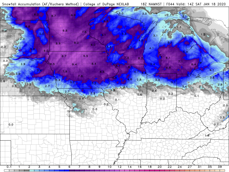
Guidance looks good, 2-5” hit area wide looking likely. .
-
RGEM has bee fairly consistent the past several runs. GEM has been in close to lock site with to. .
-
Most guidance was around 1046/1047mb for 0z, so I wouldn't say they are really off much.
-
It was a 0.25"+ event in parts of the area.
-
12/1/2007 storm in question...
-
Yea, I've forgotten to do long ranges calls on here for a while. 4.0" ORD
-
-
The "thaw" isn't even going to be that thaw-y. Might see a 2 or so hour period of 33/34 temps at best as it looks right now.
-
18z HRRR...
-
-
Sleet...
-
Knowing you and also with how the season has gone, you never know. .
-
Definitely not enough time for that to occur. .
-
That's not really how it's going to work.
-
More-so how Milwaukee will get less than Chicago.
-
wut?
-
You can say that about any snow then. We track it, it falls/accumulates, then it melts.
-
-
Rates will definitely be lower than the last storm system, so that should be a positive.
-
-
WAA criteria event is pretty easy to attain...guaranteed lock.
-
They are what this storm system is probably going to end up being... WWA criteria event.


