

LibertyBell
-
Posts
29,784 -
Joined
Content Type
Profiles
Blogs
Forums
American Weather
Media Demo
Store
Gallery
Posts posted by LibertyBell
-
-
15 minutes ago, donsutherland1 said:
La Puerta, TX also reached 116.
why is it so cold up here? you'd think with heat that strong it would push its way up here?
-
 1
1
-
-
1 minute ago, snowman19 said:
Going by past history, decades
And did the recent -PDO start somewhere around 2017 (right after the super el nino)?
And as for the AMO did that switch to negative a few years ago too?
Thanks, it's good to know where we stand.
After seeing that giant sunspot on the last day we had sunshine here (Wednesday) I know we're in for a HUGE solar storm this weekend (and maybe Northern Lights even down here). But it's not looking good for next winter at all.
-
2 minutes ago, snowman19 said:
The 1940’s-1970’s were a strong -PDO cycle. The end of the 1970’s till around 1995 was a -AMO cycle
Is there any fixed or approximate length to these cycles that we could calculate how long they last?
Looks like the AMO cycle is also important for our winters.
-
55 minutes ago, winterwx21 said:
51 degrees with light rain. As ugly as it gets for May. The only positive is the lettuce plants love this weather, lol.
We're probably going to get stuck in the 50s again on Sunday. Awful. Looking forward to getting back to the 70s on Monday. Hopefully Sunday will be our last chilly day of the season.
Saturday will be absolutely amazing with clear skies, I hope we get to see the northern lights!
-
On 5/9/2024 at 6:40 AM, snowman19 said:
We are very clearly in a long term negative PDO cycle, when this one ends is anyone’s guess. Any volcano updates?
it's around a 20-25 yr cycle I think
we had this same cycle back in the 70s to the first half of the 90s, it flipped in the mid 90s.
1967-68 to 1992-1993 was a -PDO?
That means a 25 year cycle
I'm thinking it will flip again around 2042.
We have awhile-- but it doesn't mean that we won't get good winters, they'll just be extremely rare.
We still had 1977-78 in the middle of that cycle but that was the only really good winter. Aside from that we had an HECS in February 1983 so that's the only other possibility- one HECS to make the entire winter near or slightly above average for snowfall.
-
On 5/9/2024 at 9:57 AM, WestBabylonWeather said:
It snowed here on Long Island on this date in 2020
and now we're getting a giant solar storm!
-
Why is the wind coming out of the south here? I noticed it's westerly over NJ, typically with a strong west wind it pushes all the marine air offshore and the west wind makes it to the coast after a frontal passage.
-
7 minutes ago, winterwx21 said:
Yeah low-mid 50s for highs. I don't think anyone believes we'll stay in the 40s Friday. When I said temps won't overperform due to ENE winds and rain, I meant it will get stuck in the low-mid 50s similar to what happened on Sunday. Temps are likely to be at or slightly lower than the current forecast Friday, just like they usually go higher than forecast on sunny days with offshore winds.
It was 52 here last Sunday, I think it will probably be about the same as that. Man, that day sucked lol.
Windy to boot!
-
9 minutes ago, winterwx21 said:
Temps won't overperform in our area Friday with rain and ENE winds.
It's almost impossible not to hit 50 this time of year.
So I'll go with climatology and say we will at least get into the 50s.
-
3 minutes ago, Brian5671 said:

yup looks like the rain comes back after the beginning of the week.
-
Just now, Brian5671 said:
Not really if you look at models for next week...it's a 7 day stretch of mostly garbage
I was looking at the 7 day and it looked like partly sunny Monday - Wednesday.
Our pattern seems to be nice the first 2-3 days of the week and wet and cool for the second half of each week.
-
5 hours ago, Brian5671 said:
fire up the heat!

this is probably 10 degrees too cold.
-
3 hours ago, winterwx21 said:
Stormlover called Sunday one of our top 10 worst early May days ever. I can't believe we're gonna have another top 10 worst ever for May again on Friday. Low 50s with rain again. Horrible. Gotta enjoy the warmth today because this is one heck of an ugly period coming up.
after Sunday it will be warm and dry again
-
1
-
-
11 minutes ago, winterwx21 said:
87 here right now. Humidity dropping quickly with the gusty west breeze. Feels good out there.
yes my favorite kind of weather-- except for some reason we dont have a west wind here?

-
5 hours ago, Allsnow said:
Can’t believe Friday might not get out of the upper 40’s in spots. Awful
I dont believe it, temps usually overperform
-
7 hours ago, MJO812 said:
Not everyone wants to read about people loving hot weather.
It's a weather forum. Deal with it.
Protest against your employer instead of doing everything you are told to do.
-
2 hours ago, bluewave said:
Blocking is always warm when it links up with the Southeast ridge and becomes more south based. But it results in frequent backdoor cold fronts in the spring. So we get a back and forth between warm ups and cool downs with the warm departures ultimately winning out.
We had very strong blocking in the spring during 2010 also. But it build down SW to the Great Lakes which made it the warmest spring blocking pattern on record. The ridge axis wound up to our west so we had less onshore flow than this spring.Since with more more S to SW flow. This spring the ridge axis is more into Eastern New England allowing more frequent onshore flow and backdoor cold frontal passages.


I remember seeing this map with correlations, with the midatlantic being warmer with a -NAO and new england being warmer with a +NAO and we were in between (that is much less of a correlation, at least during the spring and summer.)
2010 was definitely our warmest spring and summer on record going by 90 degree days and several years in the 90s were right behind-- specifically 1991 and 1993 as well as 1999 and 2002. 1983 was another one that was extremely hot with number of 90 degree days.
-
4 hours ago, TheClimateChanger said:
I'm just not seeing any evidence of this so-called blocking in the actual data, which shows this to be among the hottest springs ever recorded in the northeast and much hotter than anytime in the 1990s? Like wouldn't blocking make it cold in the spring?
New York, NY
Newark, NJ
Hartford, CT
Philadelphia, PA
Burlington, VT
Harrisburg, PA
Pittsburgh, PA
Buffalo, NY
Washington - Dulles, VA

2010 was definitely the hottest on record, but 1991, 1993, 1999 and 2002 came in right after that. 1983 held the record before that.
-
4 hours ago, TheClimateChanger said:
I'm just not seeing any evidence of this so-called blocking in the actual data, which shows this to be among the hottest springs ever recorded in the northeast and much hotter than anytime in the 1990s? Like wouldn't blocking make it cold in the spring?
New York, NY
Newark, NJ
Hartford, CT
Philadelphia, PA
Burlington, VT
Harrisburg, PA
Pittsburgh, PA
Buffalo, NY
Washington - Dulles, VA
the 1990s were much hotter and drier dude, compare this spring to spring 1991 in New York City that was one of the hottest summers too, along with 1993 and 2010.
Check out maximum length of heatwaves 1990s vs now. Specifically between 1991-2002.
-
14 hours ago, TheClimateChanger said:
Also, low temperatures in the 1930s and 1940s were much colder than today. You don't need air conditioning when it cools off into the 50s at night. You open the windows.
Coldest mean summertime lows
Morgantown, WV
Wheeling, WV
Warmest mean summertime lows
Morgantown, WV [some of this 19th century data is suspect, but you get the picture]
Wheeling, WV
it's because of lower humidity and much drier air back then
I loved that climate, I hate high rainfall and lower high temps.
-
15 hours ago, TheClimateChanger said:
Well you know I'm going to have to comment.
(1) Data from 1920s - 1960s is likely not directly comparable to more recent data at some of the sites. May co-op stations reset their thermometers at 5 or 6 pm, and thus would register extra 90s on hot days [when the following day may or may not have reached 90]. Would expect this to add at least a couple or few extra 90-degree days on average each year.
(2) The trend is minimal from the low elevation sites, and biased due to weighting 2020s equally even though only 4 years are included. It looks like the 2020s have had an unusually low number of 90+ days, but it's based on only 4 years of data. Same thing with the high elevation sites, but you also then extrapolate the trend back to the 1890s even though the data stops in the 1950s. In fact, the trends from 1950s to the present are about the same and we can be pretty confident that general pattern would have persisted into the 1890s. So the big drop off implied in the regression is clearly not accurate. If the remainder of the 2020s have a high number of 90+ readings, the trends could be significantly different.
(3) These trends do not agree with Philadelphia data [from a county neighboring Chester County]. These data were collected by trained meteorologists from the Weather Bureau and later National Weather Service, and thus are less likely to contain errors and are unaffected by any changes in observation time. I can anticipate you will claim the UHI effect is the culprit, but there's no explanation for why center city Philadelphia would have fewer 90-degree days than Chester County, which would have been very rural, in the 19th century and early 20th century.
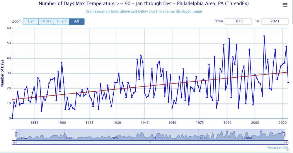
There is a reason why this is happening-- it's raining much more now than it did back then. The extreme amount of rainfall and high soil moisture is the reason why high temperatures are being blunted-- I hate it! I love high heat and low rainfall and low humidity.
-
1
-
-
On 5/6/2024 at 1:45 PM, TheClimateChanger said:
No, I don't believe the government. They have consistently downplayed this for decades. The data shows it has warmed much more than the government statistics claim.
Yes this is why action has been delayed.
It's very similar to what happened with PFOA and the sugar cartels too.
-
35 minutes ago, Yanksfan said:
It’s like if a Cat 4 hurricane is making a beeline at the city. My emotions would be on the fence between intense fear and sheer excitement.
Thats why I said I would cap all hurricanes to Cat 1 and all tornadoes to EF1, up to then it's fun and rare.... anything past 1.... no thank you, Florida can handle it a lot better than we can.
-
79 here now, it's really nice!

Extended summer stormlover74 future snow hole banter thread 23
in New York City Metro
Posted
I thought that + part of the cycle was supposed to be ending soon? Hmmm lol
When did the PDO switch to negative though, was that around 2017?