CoalCityWxMan
-
Posts
677 -
Joined
-
Last visited
Content Type
Profiles
Blogs
Forums
American Weather
Media Demo
Store
Gallery
Everything posted by CoalCityWxMan
-
Nov. 25th-26th Midwest Snowstorm Potential
CoalCityWxMan replied to Malacka11's topic in Lakes/Ohio Valley
00z runs will be interesting. -
Nov. 25th-26th Midwest Snowstorm Potential
CoalCityWxMan replied to Malacka11's topic in Lakes/Ohio Valley
That’d be a nice event for much of the area, sharp cutoff along I-55 -
Nov. 25th-26th Midwest Snowstorm Potential
CoalCityWxMan replied to Malacka11's topic in Lakes/Ohio Valley
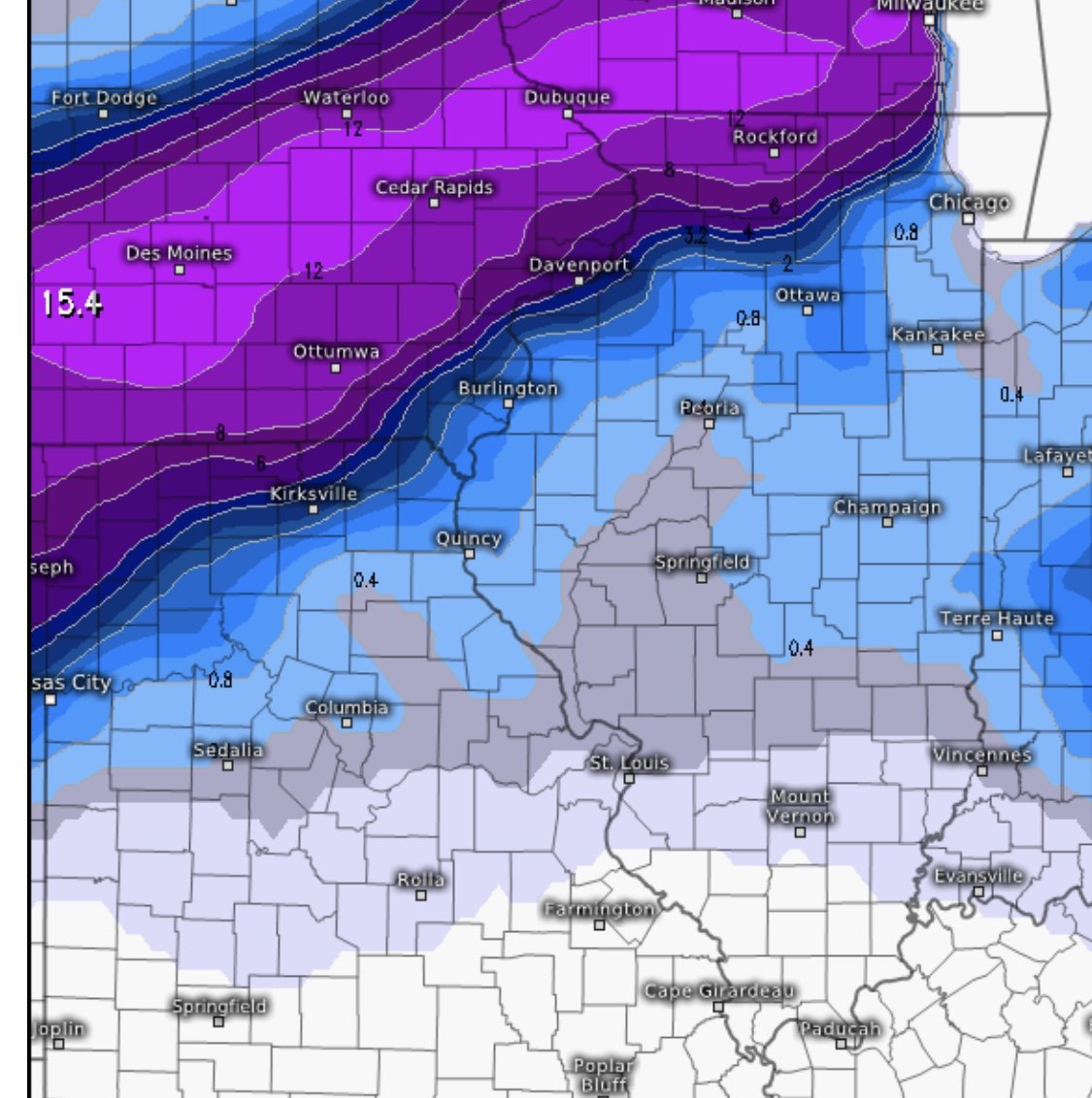
Closer look for N IL folks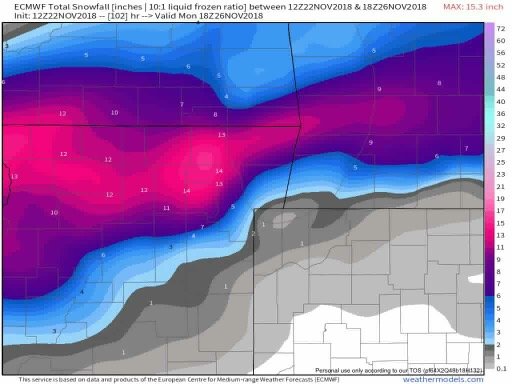
-
Nov. 25th-26th Midwest Snowstorm Potential
CoalCityWxMan replied to Malacka11's topic in Lakes/Ohio Valley
Most 12z runs thus far have bumped SE/are weaker. -
Nov. 25th-26th Midwest Snowstorm Potential
CoalCityWxMan replied to Malacka11's topic in Lakes/Ohio Valley
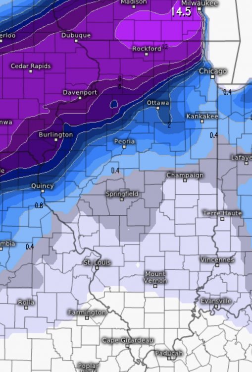
For comparison, today’s 12z EURO run vs 00z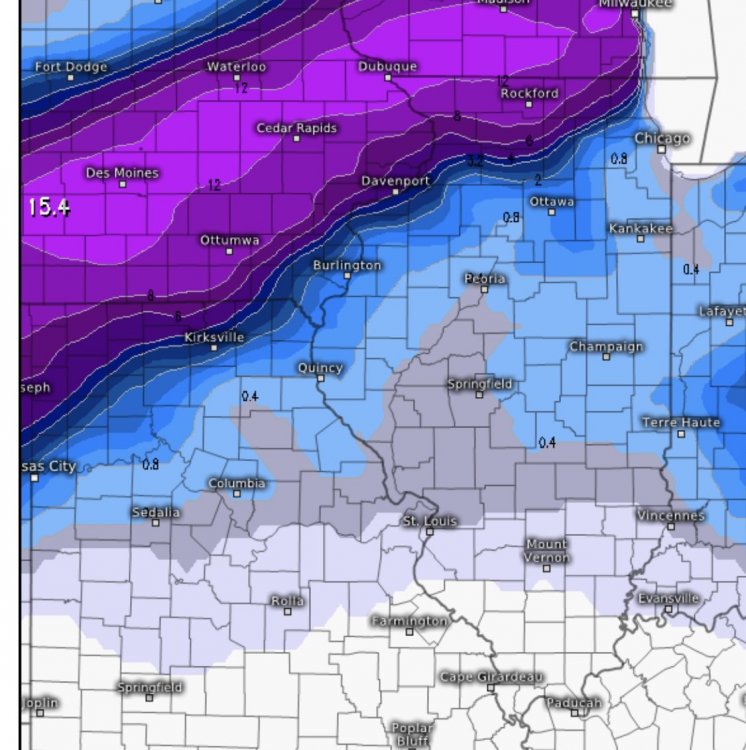
-
Nov. 25th-26th Midwest Snowstorm Potential
CoalCityWxMan replied to Malacka11's topic in Lakes/Ohio Valley
Will be interesting to watch this over the next few days, gonna be nerve-wracking for some on the edge of the heavy totals. -
Nov. 25th-26th Midwest Snowstorm Potential
CoalCityWxMan replied to Malacka11's topic in Lakes/Ohio Valley
Also, Sunday is a huge travel day with lots of people traveling back to college/home -
Nov. 25th-26th Midwest Snowstorm Potential
CoalCityWxMan replied to Malacka11's topic in Lakes/Ohio Valley
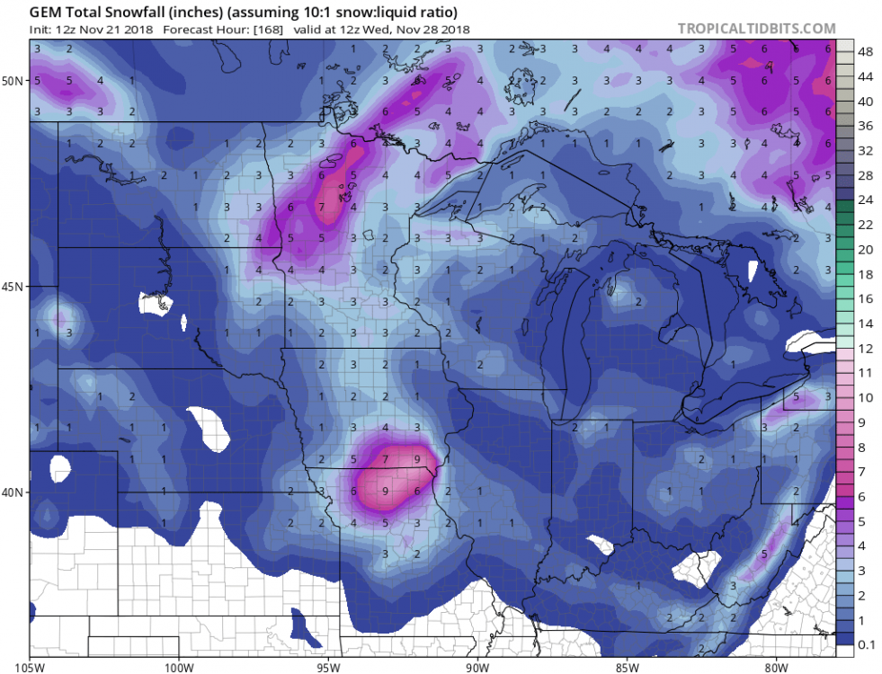
The last 3 runs of the GEM have varied just a bit..
-
Nov. 25th-26th Midwest Snowstorm Potential
CoalCityWxMan replied to Malacka11's topic in Lakes/Ohio Valley
Gut tells me it’ll shift a *little* SE and slightly weaker than currently projected just based off trends/how these sort of events seem to usually evolve. Probably won’t see much here but wouldn’t be surprised if areas on the border right now (Dekalb-Mendota areas NW) see a good amount from this, especially if that feature Hoosier talked about continues to be more prominent. -
Winter 2018-19 Medium/Long Range Discussion
CoalCityWxMan replied to snowlover2's topic in Lakes/Ohio Valley
Wow. Major snowstorm for Rockford/DVN and NW -
Winter 2018-19 Medium/Long Range Discussion
CoalCityWxMan replied to snowlover2's topic in Lakes/Ohio Valley
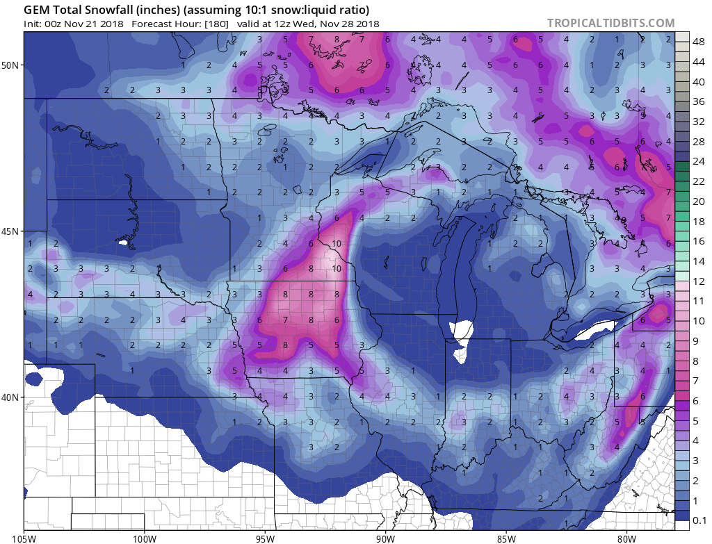
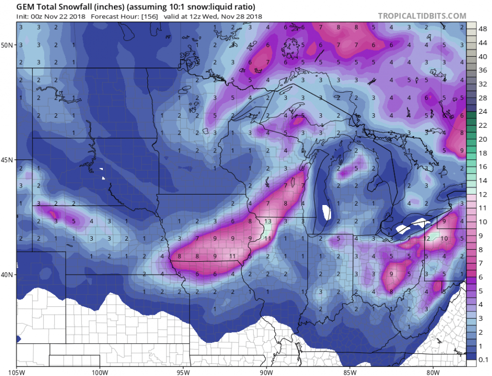
Although it’s still far out, seems to be increasing confidence in a storm system affecting the Midwest/Ohio Valley 5-6 days out. GFS is most aggressive for now but something to watch. GFS/GEM currently has a 6-12” swath of snow through central Iowa up through southwestern Wisconsin, while the Euro is further SE with a narrower band of similar amounts. -
Fall/Winter 2018-19 Complaint/Banter Thread
CoalCityWxMan replied to IWXwx's topic in Lakes/Ohio Valley
Oh the things I’d do to have this happen -
Been a nasty cold drizzle here all day despite a few flakes mixed in here and there. Hoping to get an inch or two of snow tonight though, we’ll see
-
Some models (GFS, GEM, HRRR) are showing 2-3” along/south of the I-80 corridor tonight
-
I’ll never forget that day, you woke up that morning and went outside and knew something was not right. I’m not 100% sure on this, but I think I remember reading somewhere that the PDS tor watch that was issued for most of IL and some surrounding areas was the first ever issued PDS in the 6AM-9Am time frame or something like that. Again not sure exactly If that’s what it was but I remember reading something like that a couple years back.
-
It has also been consistently shifting a little south with each run. Last night it kept everything in southern MN/WI
-
Sure did. I was very skeptical until the HRRR continuously was showing it last night. Probably overperformed even with some localized areas seeing 3”+ under the band
-
Yeah it turned to sleep for awhile but snow beginning to take back over as it begins to pivot back east. Might be able to pick up another inch
-
Yeah the public was unaware too, forecast called for a 40% chance of rain/snow
-
Ripping in dekalb.
-
Fall/Winter 2018-19 Complaint/Banter Thread
CoalCityWxMan replied to IWXwx's topic in Lakes/Ohio Valley
I don’t recall this wintry of a November in quite some time. I remember as a kid the general “rule” for November was usually seeing a day in mid/late November where a surprise dusting falls, so having repeated cold/snow chances is quite impressive. Can’t complain about the start to winter here -
The hrrr (and some other models) have been hinting at a narrow, pivoting band of snow lingering in north central/central IL tomorrow afternoon as the system weakens and pulls away. If it ends up happening could give some areas a nice surprise, wouldn’t be surprised if it did due to several models showing a feature like this. Would be a consolation prizes for what folks downstate are experiencing
-
November 8-10 Winter Weather/LES
CoalCityWxMan replied to HillsdaleMIWeather's topic in Lakes/Ohio Valley
With each run of the HRRR it has been tacking on about .1-.2” of snow with each run for areas NW of I-55. Now up to 2.5+” in the Dekalb area. Tiny differences but nevertheless, can’t wait for it to look like winter 12 hours from now. -
Things looking up for sure. Don’t remember seeing this wintry of a look in early November in a very long time
-
Both the GFS and GEM agree on a clipper type system coming through the region Friday-Saturday, certainly not the big storm modeled a few days ago but could bring some snow if it happens nevertheless.