CoalCityWxMan
-
Posts
677 -
Joined
-
Last visited
Content Type
Profiles
Blogs
Forums
American Weather
Media Demo
Store
Gallery
Everything posted by CoalCityWxMan
-
Nov. 25th-26th Midwest Snowstorm Potential
CoalCityWxMan replied to Malacka11's topic in Lakes/Ohio Valley
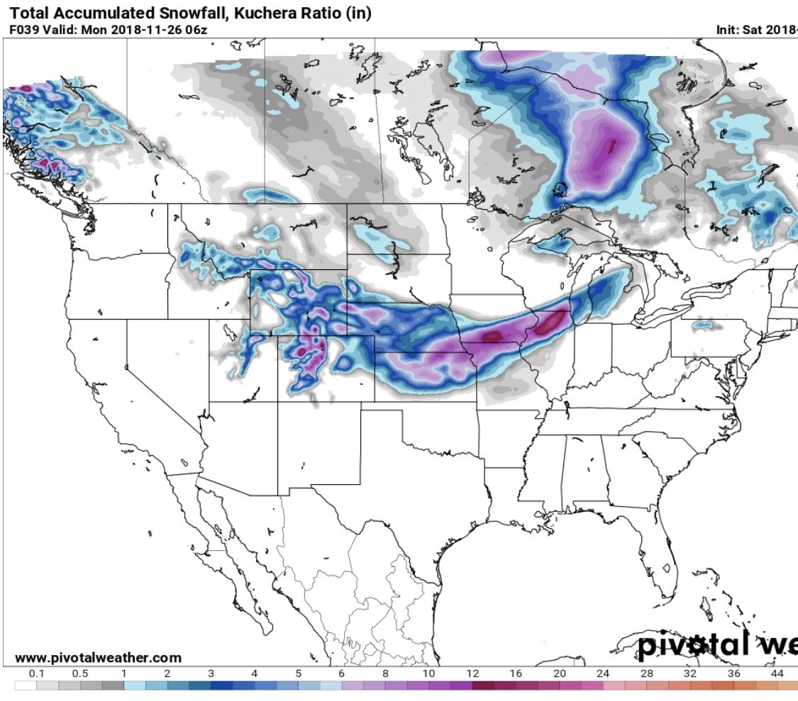
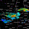
15z RAP has a nice band of 12-18” in northern IL with it still snowing at the end of the run.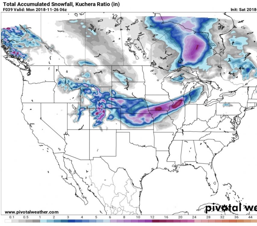
-
Nov. 25th-26th Midwest Snowstorm Potential
CoalCityWxMan replied to Malacka11's topic in Lakes/Ohio Valley
Honestly concerned about the state roads could be in tomorrow, with lots of people traveling home or back to school it could get real dangerous or even impossible to travel. Even half of what the euro is showing would be bad. -
Nov. 25th-26th Midwest Snowstorm Potential
CoalCityWxMan replied to Malacka11's topic in Lakes/Ohio Valley
Still think it’s overdone, but impressive to say the least
-
Nov. 25th-26th Midwest Snowstorm Potential
CoalCityWxMan replied to Malacka11's topic in Lakes/Ohio Valley
Euro is big again -
Nov. 25th-26th Midwest Snowstorm Potential
CoalCityWxMan replied to Malacka11's topic in Lakes/Ohio Valley
Yeah, and with college kids returning tomorrow in droves, you’d be more than busy lol -
Nov. 25th-26th Midwest Snowstorm Potential
CoalCityWxMan replied to Malacka11's topic in Lakes/Ohio Valley
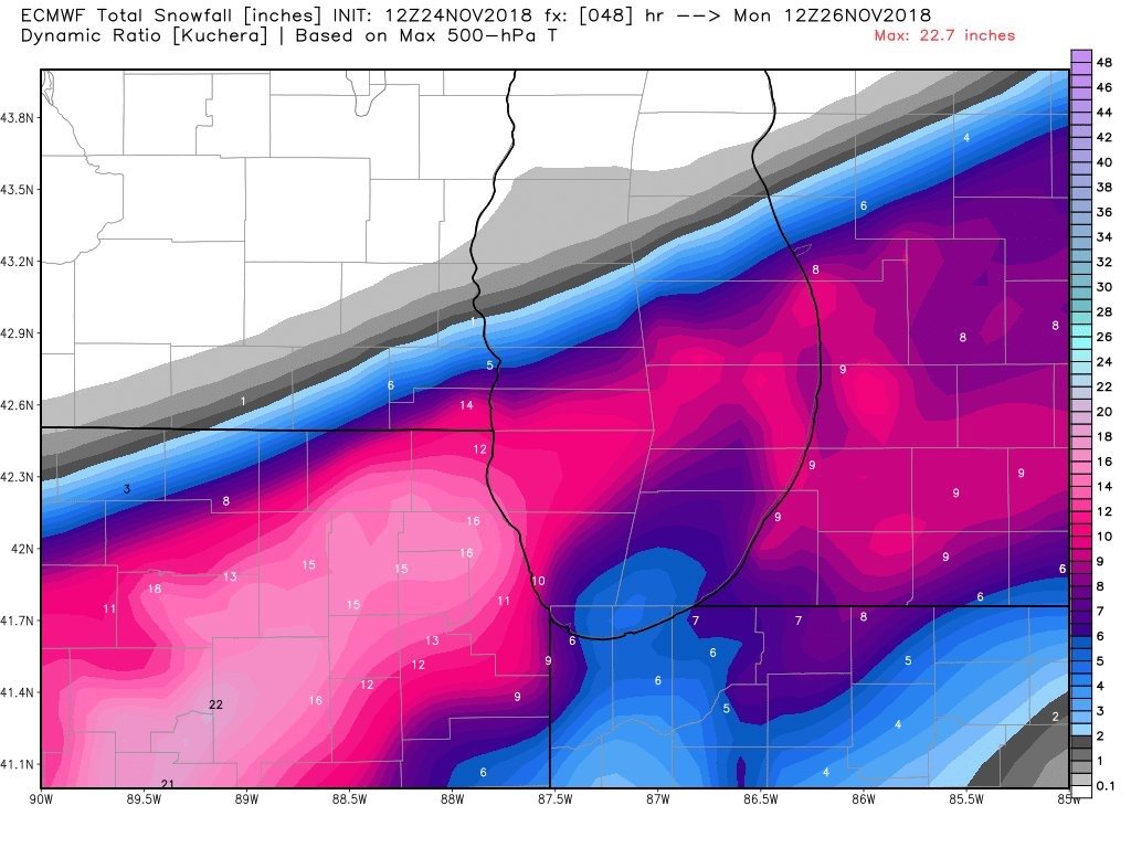
It’s like a smaller version of the euro, but similar amounts. Looks like a bullseye over Dekalb. You work in Syacmore right? -
Nov. 25th-26th Midwest Snowstorm Potential
CoalCityWxMan replied to Malacka11's topic in Lakes/Ohio Valley
Looks plausible that there could be a narrow swath of 12”+ amounts. -
Nov. 25th-26th Midwest Snowstorm Potential
CoalCityWxMan replied to Malacka11's topic in Lakes/Ohio Valley
06z NAM looks a little stronger/slower with about the same placement. -
Nov. 25th-26th Midwest Snowstorm Potential
CoalCityWxMan replied to Malacka11's topic in Lakes/Ohio Valley
The 36 hour hrrr has ratios of like 5:1 in that band lol. But it’s the 36 hour hrrr so.. -
Nov. 25th-26th Midwest Snowstorm Potential
CoalCityWxMan replied to Malacka11's topic in Lakes/Ohio Valley
This would be a complete holiday travel disaster. If the euro or any of the stronger solutions panned out many roads would be impossible to drive on, and the airports would be a mess. -
Nov. 25th-26th Midwest Snowstorm Potential
CoalCityWxMan replied to Malacka11's topic in Lakes/Ohio Valley
Guessing winter storm watches will be extended a bit south with the overnight package.. -
Nov. 25th-26th Midwest Snowstorm Potential
CoalCityWxMan replied to Malacka11's topic in Lakes/Ohio Valley
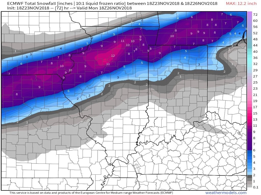
Euro is coming in hot..and staying put Edit: N IL is buried.. -
Nov. 25th-26th Midwest Snowstorm Potential
CoalCityWxMan replied to Malacka11's topic in Lakes/Ohio Valley
I have a hunch the GFS will cave and come south, atleast a little by 12z. Looking closely at the GEFS snow accum. mean, it did bump south ever so slightly. -
Nov. 25th-26th Midwest Snowstorm Potential
CoalCityWxMan replied to Malacka11's topic in Lakes/Ohio Valley
00z NAM is south, and maybe a touch weaker. -
Nov. 25th-26th Midwest Snowstorm Potential
CoalCityWxMan replied to Malacka11's topic in Lakes/Ohio Valley
It’s a new feature I believe. I didn’t know about it until a few weeks ago I saw a tweet about 18z and 06z euro runs, and I looked & sure enough. -
Nov. 25th-26th Midwest Snowstorm Potential
CoalCityWxMan replied to Malacka11's topic in Lakes/Ohio Valley
Also, here’s the HRRR at 36 hours out. Not worth much, but just taking everything into consideration at this point. Definitely further south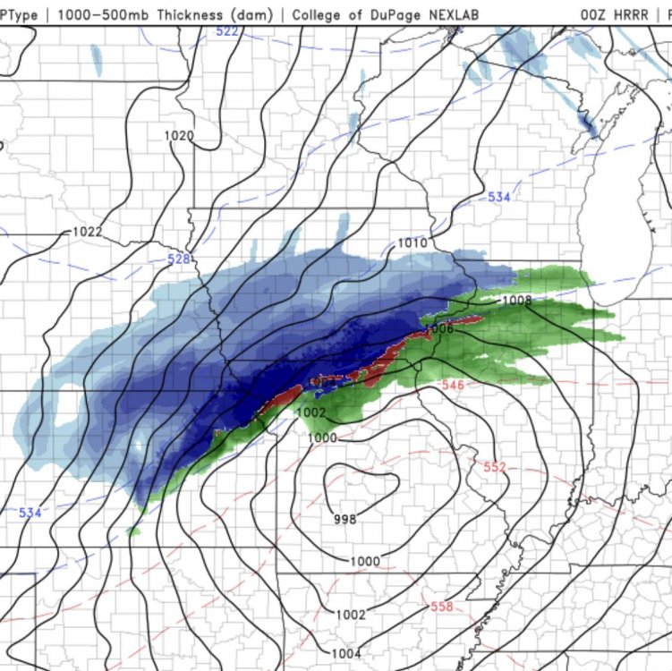
-
Nov. 25th-26th Midwest Snowstorm Potential
CoalCityWxMan replied to Malacka11's topic in Lakes/Ohio Valley
18z euro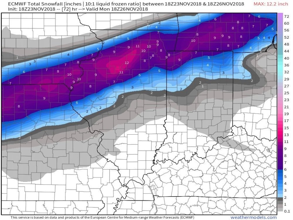
-
Nov. 25th-26th Midwest Snowstorm Potential
CoalCityWxMan replied to Malacka11's topic in Lakes/Ohio Valley
It looked north at first but in reality it’s pretty similar to 12z. -
Nov. 25th-26th Midwest Snowstorm Potential
CoalCityWxMan replied to Malacka11's topic in Lakes/Ohio Valley
Yeah I agree with that, I think the heaviest will definitely end up being north of I-80, if I had to guess now I’d say it’ll probably be centered somewhere near I-88 actually. -
Nov. 25th-26th Midwest Snowstorm Potential
CoalCityWxMan replied to Malacka11's topic in Lakes/Ohio Valley
Euro still well south. Centered around the I-80 corridor in IL and the IA/MO border roughly. -
Nov. 25th-26th Midwest Snowstorm Potential
CoalCityWxMan replied to Malacka11's topic in Lakes/Ohio Valley
New NAM looking very nice for much of LOT.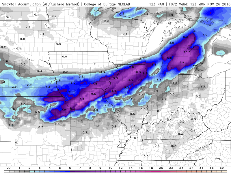
-
Nov. 25th-26th Midwest Snowstorm Potential
CoalCityWxMan replied to Malacka11's topic in Lakes/Ohio Valley
06z NAM crushes the IA/IL border into southern Wisconsin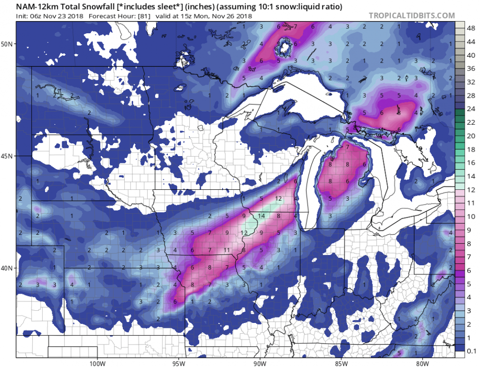
-
Nov. 25th-26th Midwest Snowstorm Potential
CoalCityWxMan replied to Malacka11's topic in Lakes/Ohio Valley
Apologies if this has been said already, but this storm could be even more impactful due to the fact Sunday is a huge travel day. -
Nov. 25th-26th Midwest Snowstorm Potential
CoalCityWxMan replied to Malacka11's topic in Lakes/Ohio Valley
Wow at today’s trends. Huge south shift. Wonder if it’ll continue or if things will correct back north -
Nov. 25th-26th Midwest Snowstorm Potential
CoalCityWxMan replied to Malacka11's topic in Lakes/Ohio Valley
At first glance it looks like 00z NAM is further south a tad