

Blue_Ridge_Escarpment
-
Posts
2,200 -
Joined
-
Last visited
Content Type
Profiles
Blogs
Forums
American Weather
Media Demo
Store
Gallery
Everything posted by Blue_Ridge_Escarpment
-

December 8-10, 2018 Winter Storm
Blue_Ridge_Escarpment replied to Orangeburgwx's topic in Southeastern States
Wetter and colder than 18Z for sure. The trend is our friend so far in the 0Z suite. -
December 8-10, 2018 Winter Storm
Blue_Ridge_Escarpment replied to Orangeburgwx's topic in Southeastern States
With Euro being the most consistent model for this storm will credence be given to that model going forward? Considering it’s in the euro wheel house right now. Thanks for answering these for us! -
Boyer said that because of the mess that was put out at GSP
-
Can GSP issue an emergency interim discussion after that 18Z suite of the GFS, NAM, and CMC?
-
December 8-10, 2018 Winter Storm
Blue_Ridge_Escarpment replied to Orangeburgwx's topic in Southeastern States
I’d love to see the faces of the night crew when they come in tonight to work on the AFD and maps and see what was put out this afternoon. -
December 8-10, 2018 Winter Storm
Blue_Ridge_Escarpment replied to Orangeburgwx's topic in Southeastern States
MUCH better GFS run. Colder aloft for sure. 540 dipping into N NC. Was in C VA last run. -
December 8-10, 2018 Winter Storm
Blue_Ridge_Escarpment replied to Orangeburgwx's topic in Southeastern States
Looks like two offices aren’t doing much collaborative work. Smh. -
Somebody already hitting the eggnog in Greer.
-
December 8-10, 2018 Winter Storm
Blue_Ridge_Escarpment replied to Orangeburgwx's topic in Southeastern States
What are they looking at? Euro, UK, FV3, CMC all show a foot and a half here. -
NE of Marion.
-
December 8-10, 2018 Winter Storm
Blue_Ridge_Escarpment replied to Orangeburgwx's topic in Southeastern States
Can anyone spot the escarpment? -
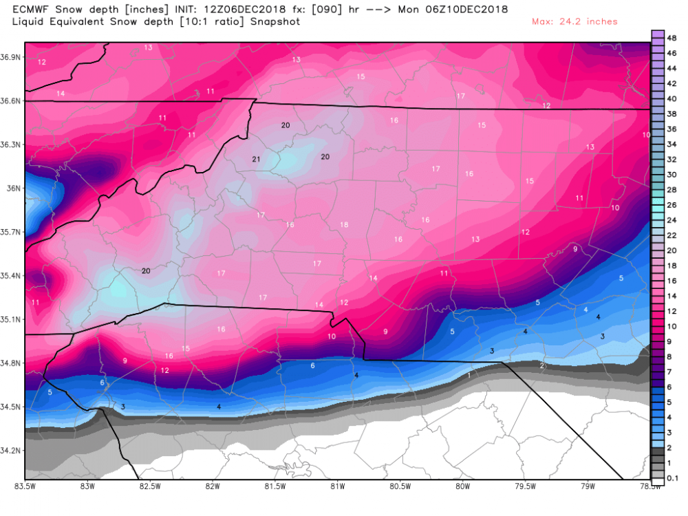
20 inches here per Euro. Wow.
-
December 8-10, 2018 Winter Storm
Blue_Ridge_Escarpment replied to Orangeburgwx's topic in Southeastern States
Canada said hold up. -
December 8-10, 2018 Winter Storm
Blue_Ridge_Escarpment replied to Orangeburgwx's topic in Southeastern States
Don’t go too high, CAD events are usually better on east facing slopes and valleys. -
3K NAM looked really good.
-
December 8-10, 2018 Winter Storm
Blue_Ridge_Escarpment replied to Orangeburgwx's topic in Southeastern States
Based on the hour 84 NAM? -
December 8-10, 2018 Winter Storm
Blue_Ridge_Escarpment replied to Orangeburgwx's topic in Southeastern States
Precip type on 12Z looks suspicious. 850s cold enough in WNC for snow during entire event. -
December 8-10, 2018 Winter Storm
Blue_Ridge_Escarpment replied to Orangeburgwx's topic in Southeastern States
Through 36, FV3 is virtually identical to its 0Z run. -
December 8-10, 2018 Winter Storm
Blue_Ridge_Escarpment replied to Orangeburgwx's topic in Southeastern States
That map actually is not too far off from what a now banned user created yesterday. -
December 8-10, 2018 Winter Storm
Blue_Ridge_Escarpment replied to Orangeburgwx's topic in Southeastern States
I read somewhere recently that it underwent an update and has actually had a slightly drier bias since. Not sure as I don’t have studies to back it up. -
December 8-10, 2018 Winter Storm
Blue_Ridge_Escarpment replied to Orangeburgwx's topic in Southeastern States
CMC just crushing I-40 and north in NC -
December 8-10, 2018 Winter Storm
Blue_Ridge_Escarpment replied to Orangeburgwx's topic in Southeastern States
It’s actually more this run if you toggle back and forth. -
December 8-10, 2018 Winter Storm
Blue_Ridge_Escarpment replied to Orangeburgwx's topic in Southeastern States
ICON finally slowly painfully trying to get a clue. -
December 8-10, 2018 Winter Storm
Blue_Ridge_Escarpment replied to Orangeburgwx's topic in Southeastern States
ONLY 15 inches this round lol -
December 8-10, 2018 Winter Storm
Blue_Ridge_Escarpment replied to Orangeburgwx's topic in Southeastern States
It’s not rain. Look at surface temps.

