

Blue_Ridge_Escarpment
-
Posts
2,200 -
Joined
-
Last visited
Content Type
Profiles
Blogs
Forums
American Weather
Media Demo
Store
Gallery
Everything posted by Blue_Ridge_Escarpment
-
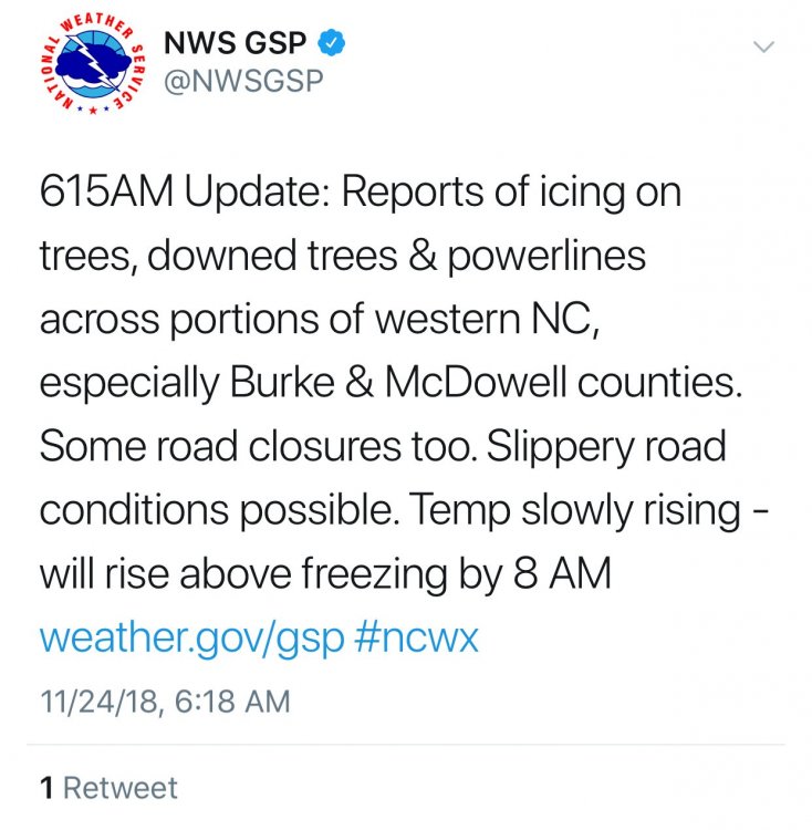
 If anyone is coming from the Cleveland/Rutherford county areas on 226 it is closed in McDowell county. Roads blocked by trees per Emergency Mgmt. Strong reported on 64 earlier.
 -
Be careful out there.
-
Power is out all across the foothills. Temps from 28-30. Close to 18,000 customers without power between McDowell Burke Caldwell and Catawba counties per foothills weather network.
-
Yeah this ice stuff we’ve had twice already is for the birds. Snow or 70 degrees.
-
Just got a text from back home in Marion and said it was absolutely pouring the sleet. Cars covered in 2 minutes.
-
Yes the NAM did over do the ice accum, however, there appears to be slightly more cold air to work with for a few hours. I’m in Florida and it’s supposed to be close to 75 today I’m just worried about my flight back into Asheville tomorrow.
-
The 12Z NAM and 3k NAM is a major ice storm for the foothills. Wow.
-
The latest NAM has come in a touch colder and for the foothill locations as this is where the cold air will hold the longest at even 12Z and 15Z its 33 degrees after being 30 for about 6 hours.
-
Looks like the foothills locations hold onto it the longest but even there, should be over to plain rain by 9-10 AM
-
3K NAM coming in colder for the foothill locations for icing event Friday night into Saturday morning.
-
Mid to Long Term Discussion 2018
Blue_Ridge_Escarpment replied to Cary_Snow95's topic in Southeastern States
Just passed 90 inches of rain for the year, 90.84 to be exact. Shattering yearly record. -
Mid to Long Term Discussion 2018
Blue_Ridge_Escarpment replied to Cary_Snow95's topic in Southeastern States
In Orangeburg for sure. From Columbia to Orangeburg and Columbia to Florence is the hottest place I’ve been in America. Oppressive heat in the summer with no breeze. -
Mid to Long Term Discussion 2018
Blue_Ridge_Escarpment replied to Cary_Snow95's topic in Southeastern States
Where did fall go? Freezing fog and 26 here right now. -
Hearing reports that 221 from Baxter up to Linville caverns is slick and on 70/40 from old fort to ridgecrest is slick as well. Be careful out there!
-
Appears that temps are on the rise in a hurry. Checked some areas that are usually cold spots, Jonas Ridge 32, Elk Park 32, Boone 31.
-
Really shocked you’re at 42. I’m already at 38 down here.
-
Going to be close. Razor thin margin of error.
-
I wasn’t overly concerned until I saw the past few runs of the RGEM along with the fact that the other global models ticking a degree colder (which is to be expected in CAD events).
-
Mid to Long Term Discussion 2018
Blue_Ridge_Escarpment replied to Cary_Snow95's topic in Southeastern States
Yes. Need to hope we hold onto sleet longer than projected. -
Mid to Long Term Discussion 2018
Blue_Ridge_Escarpment replied to Cary_Snow95's topic in Southeastern States
Under a winter storm watch and flood watch. It’s November 13th y’all. -
Mid to Long Term Discussion 2018
Blue_Ridge_Escarpment replied to Cary_Snow95's topic in Southeastern States
12Z RGEM is bad news for WNC. Gets foothill locations down to 28 during height of Precip. IIRC, RGEM has done well in CAD events. We’ll see. -
RGEM is absolute worst scenario for anyone west of 77 in NC. Gets the foothills down to 28
-
Mid to Long Term Discussion 2018
Blue_Ridge_Escarpment replied to Cary_Snow95's topic in Southeastern States
Gfs follows suit and comes in colder. -
Mid to Long Term Discussion 2018
Blue_Ridge_Escarpment replied to Cary_Snow95's topic in Southeastern States
For my backyard it was 32 with Precip falling. Only about 2 degrees warmer than 12k -
Mid to Long Term Discussion 2018
Blue_Ridge_Escarpment replied to Cary_Snow95's topic in Southeastern States
Same here today. High temp of 37 with a low of 31.


