

eyewall
-
Posts
13,298 -
Joined
-
Last visited
Content Type
Profiles
Blogs
Forums
American Weather
Media Demo
Store
Gallery
Everything posted by eyewall
-
Swing and a miss for Raleigh this afternoon. Always fun to see storms die on approach and blow up again to the east.
-
Run ahead outflow killed it today
-
We have another shot of heat coming around the 16th and 17th.
-
thank you and it is great for chasing the jungles we have here.
-
The rocket launch this morning above the patchy fog.
-
Another light show tonight:
-
Yeah it was trying for an independence day look over Raleigh:
-
Hopefully the outflow boundary delivers as it moves through Raleigh.
-
Even in Raleigh the dewpoints are extra bad today.
-
Yeah hopefully that breaks for them today.
-
I imagine we should see at least some of the D4 drop to D3 tomorrow.
-
Hopefully the trend continues!
-
Pouring here on the east side of downtown. Loving this!
-
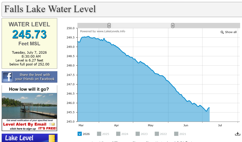
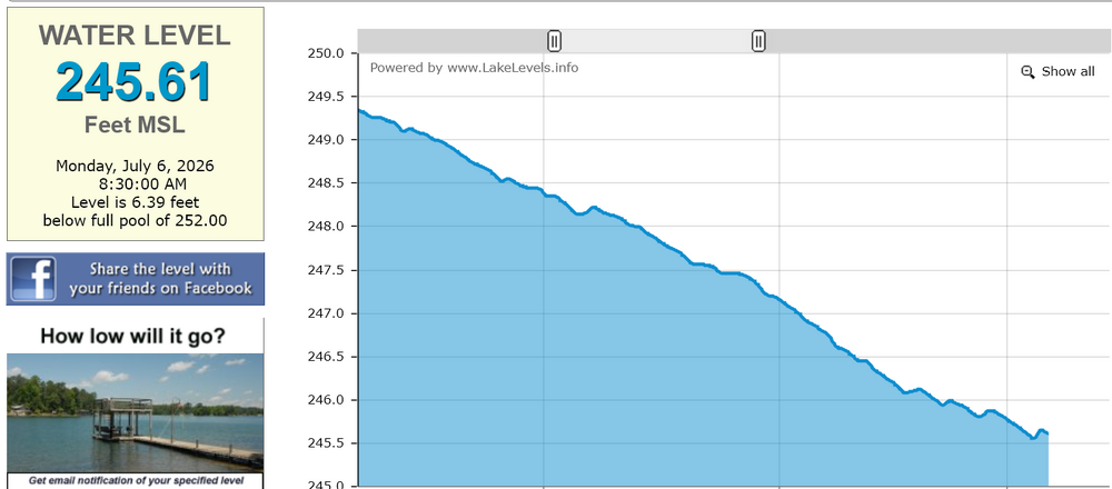
Here is the latest Falls Lake level and it made up about half of what it lost during the peak of the most recent heatwave.
-
Thank you!
-
Looking toward North Hills:
-
Locally enhanced shear due to boundary interactions gave me this brief gem!
-
I am actually here celebrating that lol
-
This graph shows the bump from yesterday's rain at Falls Lake before resuming the gradual drop:
-
The short answer is shear. In simple terms, CAPE is a measure of the fuel in the atmosphere for storms and wind shear is what allows storms to organize and not choke themselves off so quickly (should be at least 25 knots but preferably more). Today there was not much shear present so it makes more of a pulse storm scenario where they pop up and die quickly.
-
Yep the run ahead outflow killed us.
-
There is one pop up storm near Durham just west of Falls Lake but yeah it would be nice to get something. Could be some pulse severe with DCAPE values being quite high and no shear.
-
Last night in Raleigh (as close as I could fly without violating a TFR).


