sbnwx85
-
Posts
1,921 -
Joined
-
Last visited
Content Type
Profiles
Blogs
Forums
American Weather
Media Demo
Store
Gallery
Everything posted by sbnwx85
-
Also a large 45%

-
Zoomed in view
-
Sorry for the late post. I had to decompress after an exhausting two days at work covering the tornadoes and storm damage. It was another wildly memorable event for our area in an exceptionally busy Spring. I faired well in my backyard. Kept power and no damage. Obviously many nearby weren’t as lucky. We had so many amazing videos and photos to share at my tv station. It was like something out of the Great Plains. Looks like another round may be lurking next week.
-
Yesterday's line of storm was officially a derecho. Congrats to all who participated: NWS - Northern Indiana Good afternoon partners... Just as an FYI, we just received word from SPC that they confirmed yesterday's system was classified as a Derecho as it moved from Eastern Iowa through Lower Michigan. The wind swath had a track length over 400 miles, with a footprint just under 100,000 square miles. The strongest known gust was measured at 94 mph.
-
Gm bros
-
Storms crapped out just before they got this far east which was expected. Gusts to 40 mph. Big show will be tomorrow.
-
Getting excited for this one. I wish I didn't have to work because I'll be stuck in the newsroom/producer booth, but I'll be watching the storms on radar and through weather cameras. There are worse ways to make a living.
-
Hmmm... Meteorologist Ahmad Bajjey ordeonsSptl35ca7fc4lh6f7106413028f4t6g5u9a984m79fai3faif4l2m · This is going to be a bit of a read, but I want to draw your attention to something I've covered before. A little over a year ago, sweeping cuts to NOAA caused a large number of NWS locations to trim weather balloon launches either to 1 per day instead of the normal 2, or to remove launches completely. Upper-air data, the information collected by these, is the primary and overwhelming input factor into computer models. These go to everything from our forecasts, to NWS, to your app, to AI, etc. Model data fuels it all. Now, models are only as good as the data it ingests, and the more often or better the data, the more likely we can target a more accurate forecast. Notice I said more accurate, not perfect. We're not, but we do pretty darn well. Moving on. We started seeing data in models showing issues from a lack of input months ago, but I don't believe I've seen a NOAA office actually say it out loud until now. The Storm Prediction Center, the ones who are the best of the best when it comes to severe and destructive weather, creates all the daily severe weather outlooks, specifically stating they could not confirm an important part of the forecast because there was no measurement. No balloons over the Rockies or the plains this morning. Balloons launch at 0Z and 12Z each day, or they used to, and that lack of information not only affects the models but also the ability to create accurate forecasts. Kansas saw this exact issue to devastating effect this spring. We saw this issue when the northern MI ice storm showed horrible amounts of ice, and the amount was still more than any worst-case scenario model showed, as we lacked good input data from no launches in Green Bay and a single launch from Gaylord. Now, today, they all launched special 18Z balloons. Those happen on expected severe weather days. But these don't help morning or midday models, forecasts, or even aid in updating, as that is the usual window where storms may begin. Think of it like looking at a forecast, wherever that may be, and it saying to expect bad weather while it's already begun to hit. I say all of this because these are the facts. They're not pleasant, but the numbers don't lie; there is a measurable decline in model input and accuracy output. This affects every single forecaster, streamer, and app in the country. We all use the same info. And now a large agency has mentioned it directly. That's rather large weather news.
-
Best climo
-
Time to pay the pied piper after an incredible March and April. Snoozefest incoming.
-
HRRR and NAM bring 1-2” of rain to my backyard Sunday morning. Would be much appreciated if it happens.
-
Got nailed by a bowing segment at the workplace. Probably around 60 mph gusts. Power went out, generator has kicked in.
-
Seeing most reports between 55 mph and 65 mph as that line moves through NE IL/NW IN.
-
#ready2bgusted
-
And it’s gone. Realistic hope is to get some action as the boundary reignites just to my west in the early afternoon.
-
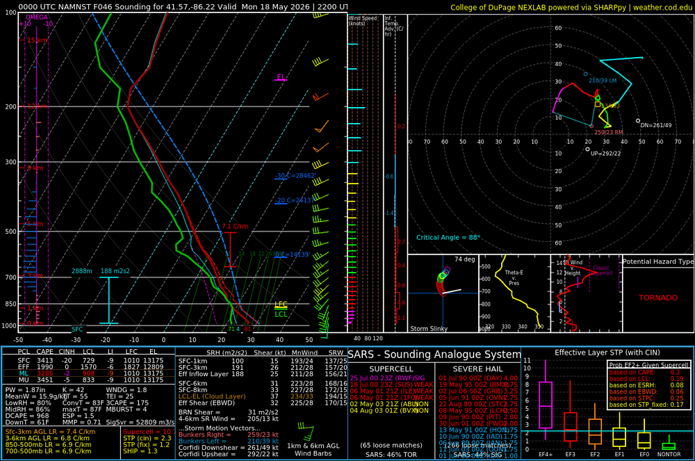
00z 3k NAM has a very impressive area of ingredients coming together in Northern Indiana and immediately surrounding areas for Monday afternoon. Nice sounding in South Bend. The HRRR much less impressive therefore I’m not showing it
-
62 and overcast. Best climo.
-
62 and full sun. Best climo.
-
Looks like more summer-like weather should return soon. So we got that going for us.
-
Decent. Constant lightning and thunder. No hail and winds gusting to about 40 mph. Nice wrinkle during an otherwise chilly pattern.
-
I was going to say this is a solid long-duration garden variety event. Then we got a Severe Thunderstorm Warning for a pretty decent looking cell just to my west. We’ll see how it holds up.
-
We got reports of snow mixing with rain in Ligonier, IN, this morning.
-
We'll add a little bit to this month's precipitation total tonight, but as of right now, South Bend has recorded 6.22" of rain in April. This makes it the 5th wettest April on record. If you combine March and April, South Bend saw 11.54" of precipitation, the 3rd most all-time for March and April combined.
-
Cold start. Might snow.