sbnwx85
-
Posts
1,832 -
Joined
-
Last visited
Content Type
Profiles
Blogs
Forums
American Weather
Media Demo
Store
Gallery
Everything posted by sbnwx85
-
Love where I sit for this one. Severe threat for damaging wind and a spin up Sunday night followed by 2-5” of snow (maybe more… we’ll see how hi-res models handle LE) on Monday/Monday night. This may upgrade my winter rating from A to A+
-
Lost power for a couple hours this morning. SBN peak gust of 59 mph.
-
I still like where I sit with the 6z euro. It is a tough look for Iowa but keeps NE IL, NW IN and SW MI in the game for a few inches of wind driven snow. I’ll be the lone positive vibe. Going to be a fun system. Slight risk of severe weather on Sunday followed by potentially near-blizzard conditions on Monday. Let’s go!
-
Lake response looks impressive. I think we can manage at least a Wind Advisory/WWA Advisory combo in N IN/SW MI. Maybe a WSW if things go well.
-
This got me thinking... we haven't had a HWW in a while in St. Joseph County. Turns out it's been the first one issued here since November of 2019!
-
Palm trees gonna get blown away. Pity.
-
Killer tornadoes, Moderate Risks, record warmth, flooding, High Wind Watches, more tornadoes?, a blizzard, a flash freeze, and Leprechaun’s that look like Farrah Fawcett.

-
Goodness gracious. This is shaping up to be one of the most memorable Marches (March’s?) in quite sometime in the lower Great Lakes.
-
Fun footnote from last night storms: SBN on the northwest side of South Bend gusted to 60 mph as the supercell collapsed south of the city.
-
Getting some good winds out of the squall line now.
-
Sounds like some damage in Knox but the EMA director didn’t sound too concerned. We also saw photos as it tracked south of South Bend but damage is relatively minor across the southern part of the county. Could have been much worse. We’ll see what daylight brings.
-
Probably need a Tornado Emergency for Knox, IN
-
Looks huge now. Heading toward Knox. Time to pray for those people.
-
Monster boy. Source: https://www.facebook.com/photo/?fbid=1450644756449709&set=a.205077084339822
-
Yeah, came back north quick. SBN jumped from 59/54 to 68/60 in an hour.
-
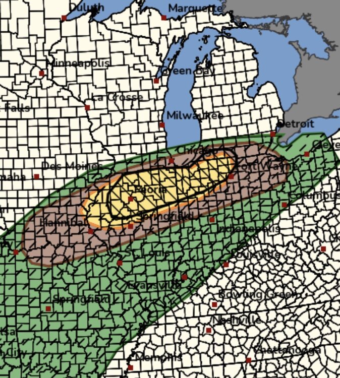
SPC might was well pull the trigger now Mesoscale Discussion 0191 NWS Storm Prediction Center Norman OK 0453 PM CDT Tue Mar 10 2026 Areas affected...portions of eastern Iowa into northern Illinois and southwestern lower Michigan. Concerning...Severe potential...Watch likely Valid 102153Z - 102330Z Probability of Watch Issuance...95 percent SUMMARY...Scattered elevated supercells and bowing segments appear likely this afternoon/evening north of the east-west warm front. A risk for significant hail and damaging gusts is possible. A WW is likely needed shortly. DISCUSSION...As of 2145 UTC, mesoanalysis and radar observations showed an east-west oriented warm front stretching from eastern IA, across northern IL into southern lower MI. South of the front, temperatures in the 70s and 80s F amid mid to upper 60s F surface dewpoints are supporting moderate to large buoyancy of 2000-3000 J/kg of MLCAPE. Strong destabilization is also ongoing in an elevated manner along and north of the boundary with 1500-2500 J/kg of MUCAPE despite cooler surface temperatures. Strong mid-level flow is overspreading the boundary supporting deep veering wind profiles supportive of organized severe storms. Weak surface convergence southeast of the front has ignited several supercells across northern IL this afternoon. As storms cross out of the Tornado Watch and the front, they will become elevated. With robust buoyancy and deep-layer shear greater than 50 kt, they are likely to remain intense and capable of large to very large hail. Recent CAM guidance and surface convergence near a surface low in IA/MO suggest numerous storms will develop within the elevated regime over the next few hours. With time, these initial supercells are likely to grow upscale into elevated bows or clusters with a continued hail threat and possibly damaging winds associated with strong gravity waves propagating along the top of the stable surface layer. Given the increasing severe threat, a new WW is likely needed for eastern IA into northern IL and portions of western lower MI. ..Lyons/Hart.. 03/10/2026
-
Bout to pop off.
-
Hrrr keeping the supes well west. It makes the main show the squall line at about 1 am. Good dynamics in place to spin up some twisters within the line tho.
-
Happy double hatched 10 percent tornado day for all those who celebrate.

-
A couple counties around here canceled the test today citing the confusion and the fact they already tested them last week. The severe threat looks substantial here in Northern Indiana. That warm front is going to cut right through the area and any storm that latches onto it could rotate violently similar to what we saw in Michigan on Friday.
-
Gonna get wild tomorrow.
-
Police confirm it was a 12-year-old boy who died in Cass County. Based on police reports and scanner traffic, there was no warning when the house was struck.
-
Today's high of 76 in South Bend obliterated the daily record high of 71 set back in 1973.
-
FWIW, Branch Co. Sheriff's Office says three dead, 12 injured. Of those 12, three are in the hospital. Cass County Sheriff confirms one dead, several injured. We are hearing it was a child, but that is unconfirmed. Devastating day for SW Michigan. Saw this on Michigan Native Photography:
-
It's police scanner traffic so take it with a grain of salt, but a house may have just been hit with a tornado (or downburst) in Cass Co. MI.