Eskimo Joe
-
Posts
24,727 -
Joined
-
Last visited
Content Type
Profiles
Blogs
Forums
American Weather
Media Demo
Store
Gallery
Everything posted by Eskimo Joe
-
Eric Webb and Alan Huffman are probably salivating right now.
-
Snow and falling temps are great. Cold powder with no temp worries. Deep winter
-
12z EPS implies we get snow this weekend. Not everything can be a BECS. Would be an advisory type event. Not terrible.
-
Nice to see the ensembles agree with the OP. If the Euro looks anything like the Canadian, we might be on the way to stealing a third event inside 120 hours this winter.
-
Adding onto my previous post, if the 12z CMC were to verify, it would bring DCA to near full climo for yearly snowfall.
-
12z CMC is nice for the weekend. Solid warning level event, no temp issues.
-
Ji volunteers
-
Tomer and Tony (WPC met) are getting interested in this weekend's potential
-
Euro at 500 starting at HR 150
-
I can see the appeal, but the argument that I was making is that big storms seem to kick good patterns out of the area faster. Take a look at Jan 2016. Solid event, but 3 days later we're roasting and the snow is melting off fast.
-
Yea it seems like we want to "sacrifice" this storm to set the table.
-
To be honest, I'd trade a lone 3 foot blizzard for several 6" - 10" events and normal/below normal temps. Getting on big storm and watching it melt in 5 days is boring. Let's get and maintain a snowpack for once.
-
@brooklynwx99 with the early morning dirty talk.
-
Yea, would make 2016 look like nothing.
-
Yea, as @Bob Chill said. Big high to the NW and even Ian on Twitter is liking the potential. Next two to three weeks could be really interesting. Peak climo for cold temps too.
-
12z GFS w/ 41" at IAD, 33" at DCA, 29" at BWI in the long range. Somehow, Ji will scoff at this, but holey moley am I excited about the next three weeks. Could be an epic time. Haven't been this optimistic since 2009 - 2010.
-
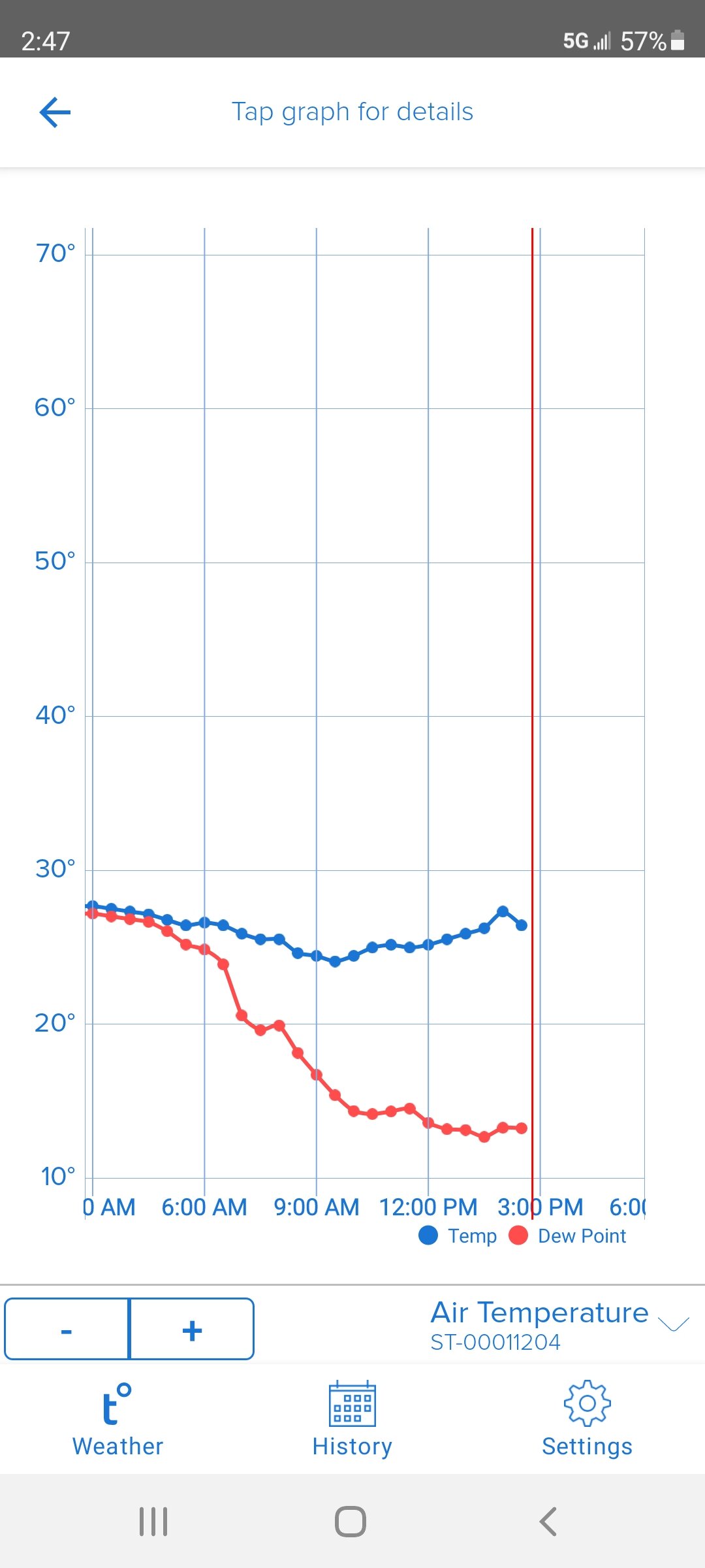
Despite full sun, temps are riding the struggle bus. Only 26 and we've probably peaked for the day.
-
Some of the snow loss is due to sublimation from the dry, cold air. We see that with really fluffy dry snow.
-
-
Yea the HRRR and RAP were too dry across the board. When that early band was putting down 1"/hr rates along I-81 the RAP still had no snow.
-
Storm total of M5.5" New Windsor at 6:00 am.
-
If this system was just a bit more organize and juiced, some folks would've probably hit double digits. No worries though, we went from 60s this past Sunday to two snow events. Not too shabby.
-
GFS scores another win. It seems to out perform the Euro and UKMET with these northern stream systems.
-
We got alerted for a call at the fire department then canceled so I'm up writing the paperwork.