so_whats_happening
-
Posts
1,577 -
Joined
-
Last visited
Content Type
Profiles
Blogs
Forums
American Weather
Media Demo
Store
Gallery
Everything posted by so_whats_happening
-
DCA _ NYC _ BOS _ ORD _ ATL _ IAH _ DEN _ PHX _ SEA -2.2 -2.3 -2.5 -1 -0.4 0.9 2.1 2.4 1.6
-
2025-2026 ENSO
so_whats_happening replied to 40/70 Benchmark's topic in Weather Forecasting and Discussion
We are officially in a WQBO descending phase so we should be right near that transition come next winter so may be a little interesting to start off. Not sure about the transition to full on Nino but plenty of time to discuss. -
2025-2026 ENSO
so_whats_happening replied to 40/70 Benchmark's topic in Weather Forecasting and Discussion
Fair point it really has been awhile for that type of pattern. There is a large amount of cold air this year which I have been told ad infinitum that this will not be a thing going forward. The longevity is something else this year. -
2025-2026 ENSO
so_whats_happening replied to 40/70 Benchmark's topic in Weather Forecasting and Discussion
Yea seems like a coast to coast type of pattern. Which is not terrible for this time of year makes me happy to see a potential moist pattern finally trying to set up regardless of snow or rain. -
2025-2026 ENSO
so_whats_happening replied to 40/70 Benchmark's topic in Weather Forecasting and Discussion
It does tend to translate to the surface quicker this time of year. As for what Stormchaserchuck has said it needs to be a large event that takes place to really nail that possibility in. I have this feeling we may fall short of an actual split but overall I don't think it impedes our overall pattern progression. The split would just help lock in the pattern longer but at this rate im fine with it not locking in. If we somehow get this system over the weekend I don't know where we will put the snow as it has taken a huge effort to clear what we just had and area wide saw 8-12" of snow/sleet (we saw about 10") -
2025-2026 ENSO
so_whats_happening replied to 40/70 Benchmark's topic in Weather Forecasting and Discussion
If you click on the link I provided it is important to note there are not a lot of examples to determine either ENSO neutral or Nina of a solid phase 1 passage in February and the resulting effects. Nino is not there at all which is a bit strange. If you look at the Nina depiction it is a big cold press into the east based of the 500mb pattern with a follow of warming into the plains which would alleviate much of the east at some point. Do I think it will happen, well I honestly would not be surprised if we relax the cold pattern a bit but im not expecting torch like behavior. To me it seems the results are more of a mixed bag and could easily be explained by other more prevalent signals such as PDO/ PNA/WPO/ NAO etc. If we do indeed get this SPV split all bets are off into either direction of where we go but one would assume we tend to re enforce the pattern we currently would have leading into the split. -
2025-2026 ENSO
so_whats_happening replied to 40/70 Benchmark's topic in Weather Forecasting and Discussion
Surface reflection of the Nina is starting to dwindle a bit more quickly so I would assume the idea is the influence as we get into February will be more muted in time. I would like to see just how much of the waters with depth east of Japan have been chewed up this year still have and will probably continue to have the -PDO tongue for quite some time. https://psl.noaa.gov/map/clim/sst.anom.anim.week.html -
2025-2026 ENSO
so_whats_happening replied to 40/70 Benchmark's topic in Weather Forecasting and Discussion
It does have flares of 2018 progression via breaking down the SPV but no two years tend to be alike as for surface/500mb progression. Should have a better idea as we close out the month how things should translate in the mean time we have some fun patterns evolving that need to be watched. If I had to take an early guess I would say we run the risk of continuation of the current pattern as the the downwelling, were it to occur, would just enhance the already lower atmosphere -AO pattern. That early wave 1 warming did quite a bit to help as bluewave pointed out while it would be nice to extend this cold/snow pattern i'm fine with winter breaking down around presidents day. lol After tomorrows snow (8-14" looks to be the range for us) we should be less than 10" away from hitting average with some solid potential trying to show up. Let's see what happens as the cold starts to relax a bit. -
2025-2026 ENSO
so_whats_happening replied to 40/70 Benchmark's topic in Weather Forecasting and Discussion
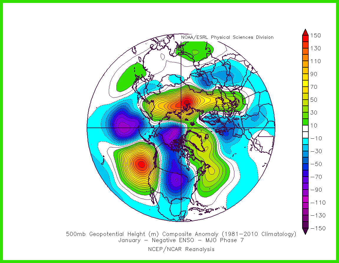
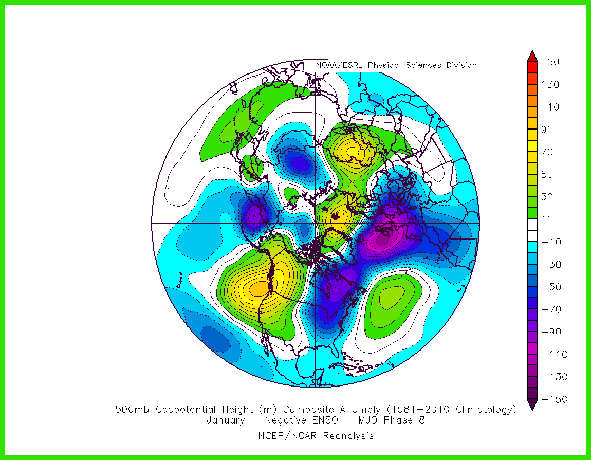
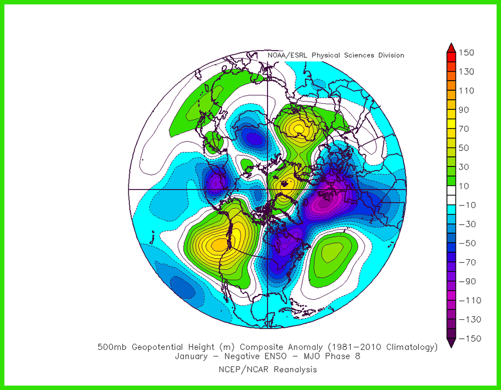
Phase 8 in February starts to get ok but phase 1 in February in Nina is a large warm up. If we have more of a neutral state rather than La Nina by then with a passage through phase 1 in February it is a bit more muted of a warm up. Looks fun though coming up for at least the next maybe 10 days. https://www.meteonetwork.it/models/mjo/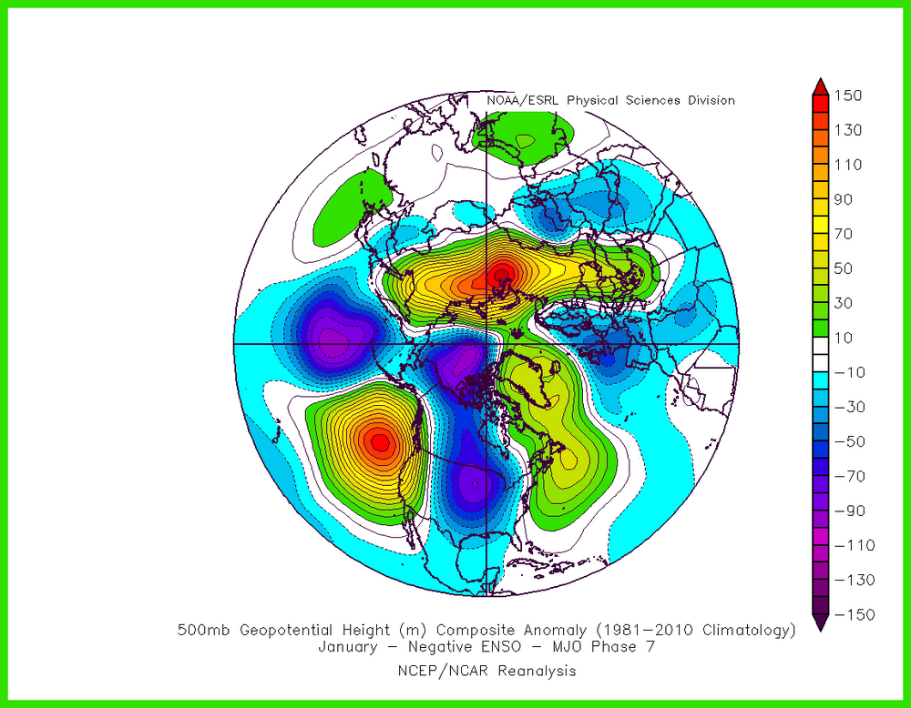
-
2025-2026 ENSO
so_whats_happening replied to 40/70 Benchmark's topic in Weather Forecasting and Discussion
Pretty solid depiction
-
2025-2026 ENSO
so_whats_happening replied to 40/70 Benchmark's topic in Weather Forecasting and Discussion
Love it and maybe a classic is trying to set up. -
2025-2026 ENSO
so_whats_happening replied to 40/70 Benchmark's topic in Weather Forecasting and Discussion
I am not sold on any of that we would need more indications for me to say oh yea it looks to be heading that route. Plenty of time to discuss though. Until then cold and snow rule the game potentially over the next week and change. -
2025-2026 ENSO
so_whats_happening replied to 40/70 Benchmark's topic in Weather Forecasting and Discussion
That is certainly interesting but placement leaves me concerned. First time in years we have a decent wave 2 production shame to see the pacific side of things weaken so much. Honestly though we are nearing February and I would not mind at this point if by mid month we push into a milder pattern into spring. I love snow but extending it into march and even april is not fun. -
2025-2026 ENSO
so_whats_happening replied to 40/70 Benchmark's topic in Weather Forecasting and Discussion
Yea im not so sure it is fully necessary but would be nice to see an increase in overall precip across the country that a +PDO tends to bring. -
2025-2026 ENSO
so_whats_happening replied to 40/70 Benchmark's topic in Weather Forecasting and Discussion
It certainly is but man this cold coming in is something else would not be surprised if we face single digit highs thrown in there next week and lows could be at or below 0. We face a relaxation period I want to say the beginning of February ( around the first weekend?) before a potential reload to the pattern. Also need to watch the storm threat from such a retreat of cold. That subsurface warm pool has not budged for almost 2 months now and is moderating things further east. This seems like we go warm neutral into next fall/winter. -
2025-2026 ENSO
so_whats_happening replied to 40/70 Benchmark's topic in Weather Forecasting and Discussion
Fun 1 month SSTA map. I'm impressed how much ice has been able to form in the Bering Sea this year.
-
2025-2026 ENSO
so_whats_happening replied to 40/70 Benchmark's topic in Weather Forecasting and Discussion
Ill wait until my heating bill starts to reflect these notions of warmth and sustained warmth above 50 is on the way. -
2025-2026 ENSO
so_whats_happening replied to 40/70 Benchmark's topic in Weather Forecasting and Discussion
Always does after 240hrs whether it be La Nina or El Nino. I would not look past 240 in any regard not sure what is going this year with models having such wild swings but they are not even in lock step with each other past 96 hrs. -
2025-2026 ENSO
so_whats_happening replied to 40/70 Benchmark's topic in Weather Forecasting and Discussion
I applaud you for taking the advice and using a single source for both. I still don't like the SSTA-Global map but that is of my own. Do you happen to have the site to see the depth of the warmth within this region or is that just a twitter thing? I do find this year interesting even though we are in the Nina like atmospheric pattern/ base state it is not typical for us to see systems (in this particular pattern) going up the coast with little affect from a SER feature especially since we are entering mid to late January. This would and should be a time period where we see systems running right into the lakes almost similar to the a few days ago but over the next week and change we look to have this Nino like pattern evolve something is just off about this year so far. The -PDO is 100% responsible still for the lack of precip in the east and SE how long that lasts will another interesting thing to watch over the next couple months. I personally would have thought by now we would at least be touching near average monthly precip totals. -
2025-2026 ENSO
so_whats_happening replied to 40/70 Benchmark's topic in Weather Forecasting and Discussion
This may the response from the EWB Don was talking about a cooling of 3.4 (briefly) and a warming further east (potentially also briefly?). Sustainability unsure but would at least look to allow a MJO wave to past through weak. What concerns me still within the subsurface is the persistent cold pocket 140W roughly 150meters below the surface. That has a very persistent feature over the last ~4 years, even during the Nino event.
-
2025-2026 ENSO
so_whats_happening replied to 40/70 Benchmark's topic in Weather Forecasting and Discussion
I dont follow online meteorologists because social media is a cancer that being said this go around might be interesting. Let's see how the EPAC evolves over the next few weeks. This would give credence for a weak phase 8 and jump to 1 and eventually 2/3. -
2025-2026 ENSO
so_whats_happening replied to 40/70 Benchmark's topic in Weather Forecasting and Discussion
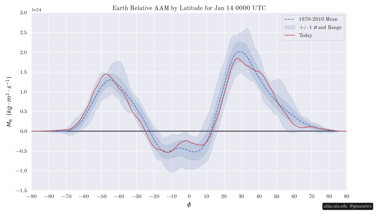
Location is also extremely important for where these anomalies exist. https://atlas.niu.edu/gwo/ While the tropics are exerting more of a El Nino flair which may very well be enhancing some of these cold dumps horse to mid latitudes have not yet caught up.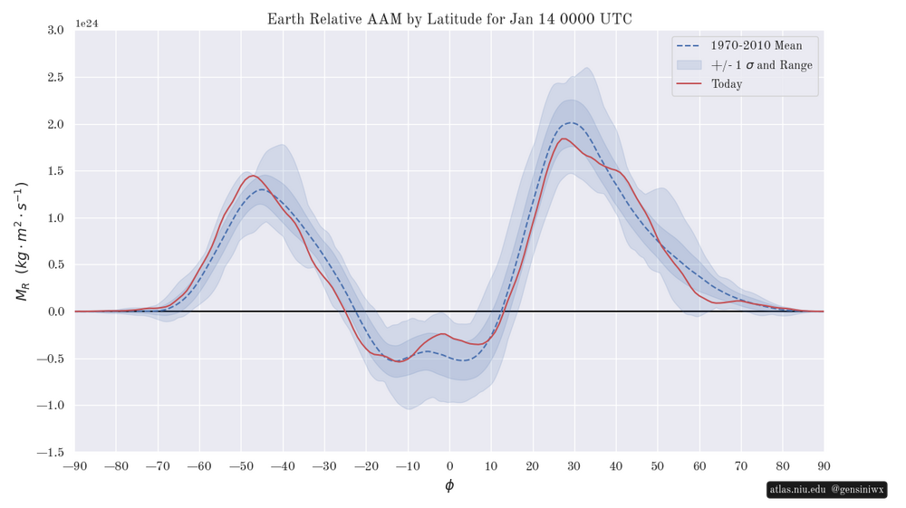
-
2025-2026 ENSO
so_whats_happening replied to 40/70 Benchmark's topic in Weather Forecasting and Discussion
Im not a fan of cherry picking charts. I remember rather well that CDAS 3 years ago during the Nino event was showing SSTs in the moderate to low end strong sector (roughly 1.3-1.5C above average) when almost every other (OISST, ERSST, CRW, etc.) was showing the waters near upper end strong. Now we use it to show La Nina? Come on with that. Honestly if you are going to show these types of charts in either picture stick to one source. -
2025-2026 ENSO
so_whats_happening replied to 40/70 Benchmark's topic in Weather Forecasting and Discussion
This shows some pretty bad forecasts. Late December is the first set of images and the latter is as we close in on mid month. -
2025-2026 ENSO
so_whats_happening replied to 40/70 Benchmark's topic in Weather Forecasting and Discussion
I am honestly on the fence with it. Typically we only see a full destruction of the SPV 1-2 times a decade. I have a feeling we may have to wait but hope I am wrong.