StormchaserChuck!
-
Posts
2,274 -
Joined
-
Last visited
Content Type
Profiles
Blogs
Forums
American Weather
Media Demo
Store
Gallery
Everything posted by StormchaserChuck!
-
Seems like there is a lot of potential for a +500dm block in the 15day range.. either -PNA, -WPO, or -NAO, I wonder if it's associated with a 10mb warming, if so that's a ~Jan 20-25 -AO/-NAO signal.
-
Thanks for the research/point, the Gulf coast jet stream doesn't really pick up until mid-January. Look at this though
.thumb.gif.27ea3fead9c1ee3b44be7c32bf3265b2.gif)
-
Yeah it's always going to be negative these days, we have a big Pacific drought, High pressure hitting somewhere over there. I think we can do well snowwise with a -NAO, seems we are due for more precip too.
-
New GFS ensembles bring -NAO in much better.. +360dm's hitting on almost half of the members at 192hr.
-

December 2021 Medium/Long Range Discussion Thread
StormchaserChuck! replied to North Balti Zen's topic in Mid Atlantic
97-98 had a -NAO period, too.. our 2 least snowy Winter's. This LR -NAO if it happens like on models will make 22 straight -NAO's with a -PNA or +EPO, going back to 2018.. the West to east jet stream has tremendous power.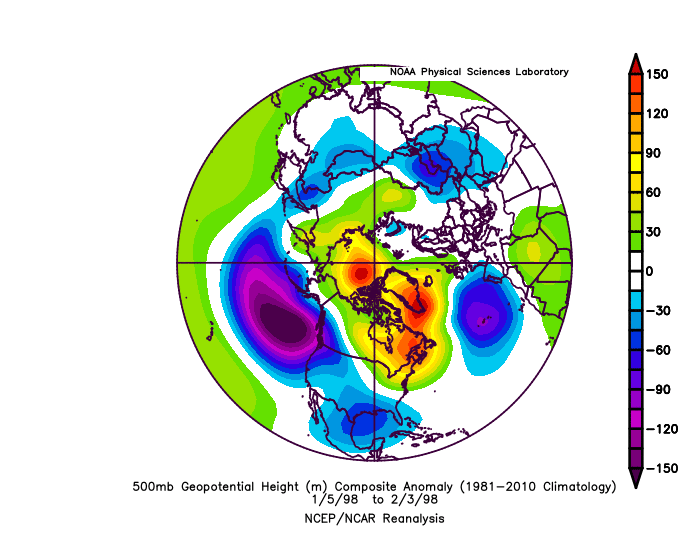
-
December 2021 Medium/Long Range Discussion Thread
StormchaserChuck! replied to North Balti Zen's topic in Mid Atlantic
3 strong cold waves around -NAO on 15day models for 5 straight runs now. I like it, 4 waves around -NAO, we'll get a snowstorm if it happens like this. Last 3 models runs have been cold in the NE.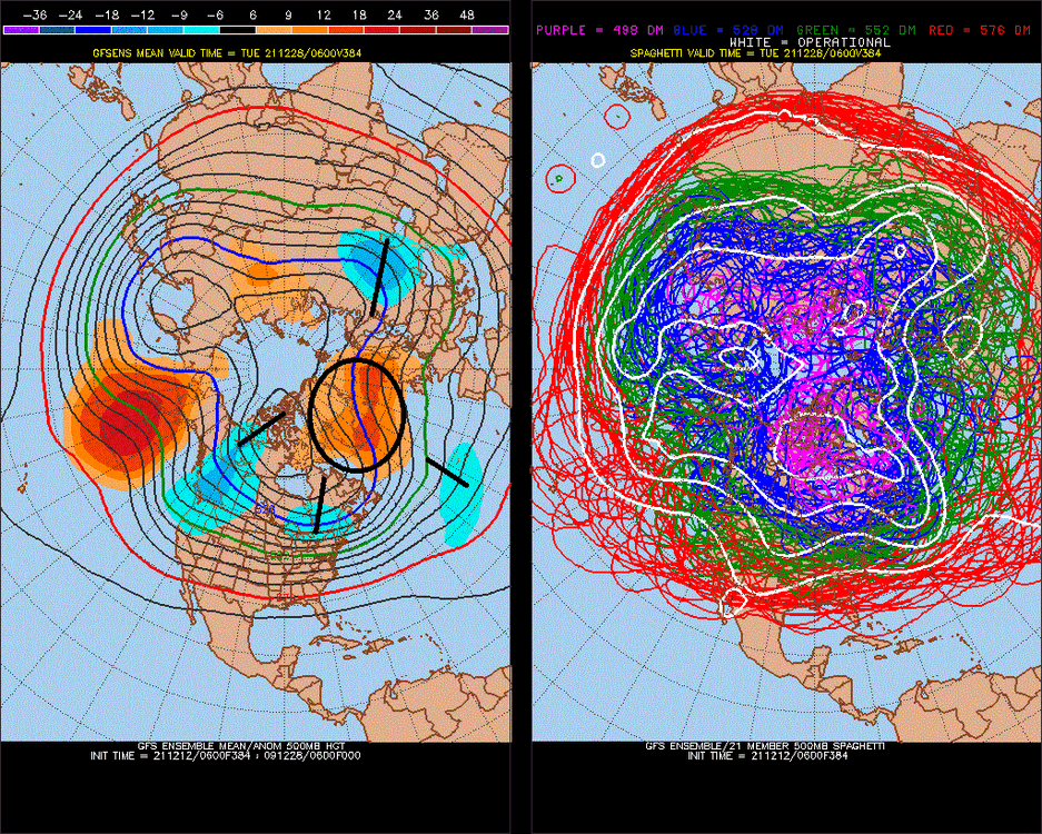
-
December 2021 Medium/Long Range Discussion Thread
StormchaserChuck! replied to North Balti Zen's topic in Mid Atlantic
It may be temporary.. we have been -NAO 70%of the time August-now so.. -
2021-2022 ENSO
StormchaserChuck! replied to StormchaserChuck!'s topic in Weather Forecasting and Discussion
Wondering what will happen around jan 15th, as we are doing opposite of last year.
-
Had like the 3rd thunderstorm of the year here tonight (well it was windy)
-
Big Pacific -PNA pattern happened last year Jan 15th on, maybe we will veer more +PNA Jan 15th on?
-
We've been running perfectly opposite at 500mb anomalies Aug-Dec25th vs last year, Maybe the big -PNA will flip January 15th on?
-
December 2021 Medium/Long Range Discussion Thread
StormchaserChuck! replied to North Balti Zen's topic in Mid Atlantic
Remember, the last 4 Christmas' in the midst of big +NAO Winter's This coming -NAO may have less staying power?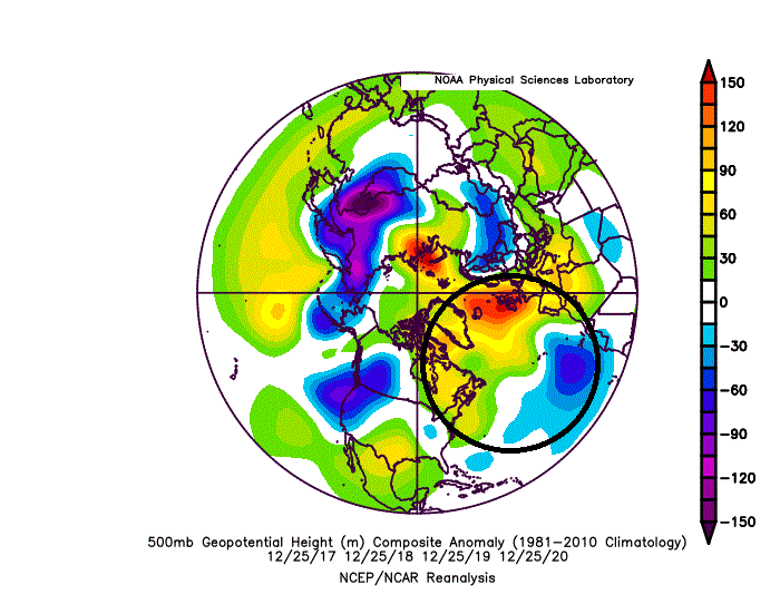
-
2021-2022 ENSO
StormchaserChuck! replied to StormchaserChuck!'s topic in Weather Forecasting and Discussion
I think we're trending for a snowier Winter next year, right now. I want to see if the +ENSO develops after ~+0.3 in ~April. The trend for the last few years has been a reversal of the warmth after some warm pockets surface. I think all the analog stuff showing an El Nino has little weight.. -
2021-2022 ENSO
StormchaserChuck! replied to StormchaserChuck!'s topic in Weather Forecasting and Discussion
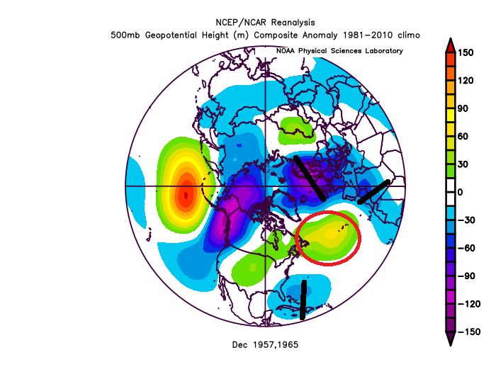
^40/70 it's a pretty awesome signal, December -PNA = El Nino soon after (usually you are always on one side of consistency for the sake of randomness). Also Dec 1957 and 1965 had big -PNA December's and were followed by -NAO fwiw I'm kind of worried about the displaced -NAO though (could be some +NAO-default tendency this year) (I like because they were El Nino years and it kind of matches the encroaching subsurface warm pool.)
-
Yeah, the world is changing man. Chase your snow. I enjoy it, the deep gray clouds, falling snow from the sky. I wanted to live in Canada and just move around.
-
`100" yeah!
-
I watch those satellite maps like a lot, and they drive me crazy! One time I found 11-1-11 in LA etc, 500mb anomalies that could even be "time travel lol. There were like 13 of them. Anomalies on round number days.
-
December 2021 Medium/Long Range Discussion Thread
StormchaserChuck! replied to North Balti Zen's topic in Mid Atlantic
Yeah, our best pattern for big snowstorms is GOA Low, which is actually not far from -PNA(-PDO pattern). Problem can be the STJ. -
December 2021 Medium/Long Range Discussion Thread
StormchaserChuck! replied to North Balti Zen's topic in Mid Atlantic
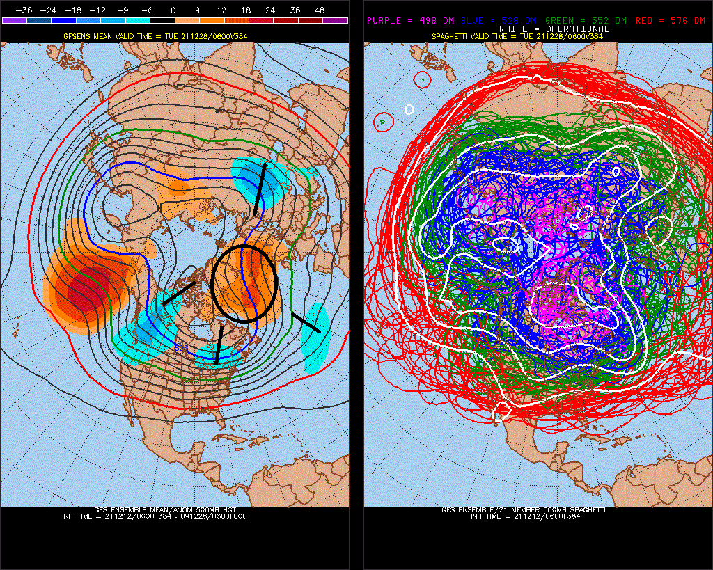
Real nice -NAO here at 384hr on Christmas. 3 strong cold waves around. -PNA with it too though. I think we had a progressing -NAO in Aug, Sept, Oct, Nov so we can do this. -
It also might be hard to flip that NAO(from now)
-
2021-2022 ENSO
StormchaserChuck! replied to StormchaserChuck!'s topic in Weather Forecasting and Discussion
Not really sure who gets this.. it took 30 seconds to load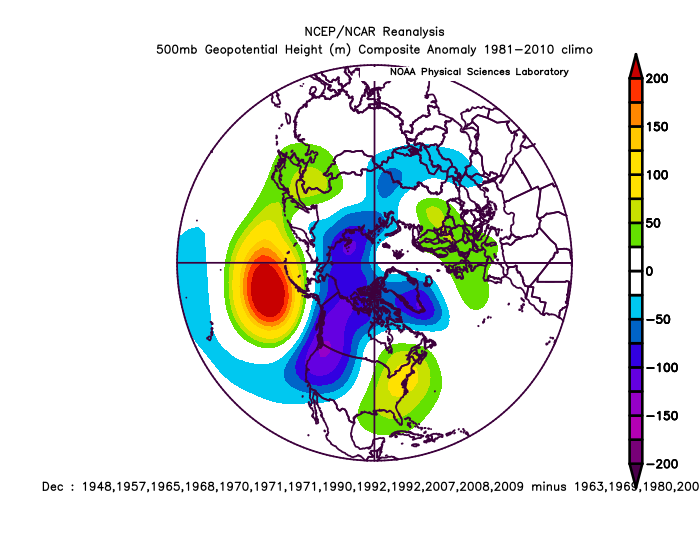
-
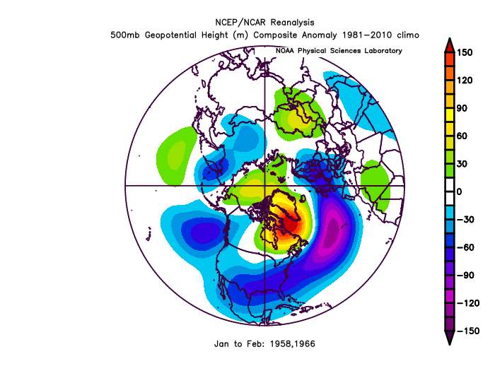
December is interesting in the satelite data, first non -PNA year was 1959. , 11 year later. 1995 Dec 1995 was the biggest +PNA. Not a lot of matches with consistency or what we know as ENSO. My Winter-thread post is lingering, I wonder if Im connected the same as everyone? Probably not.
-
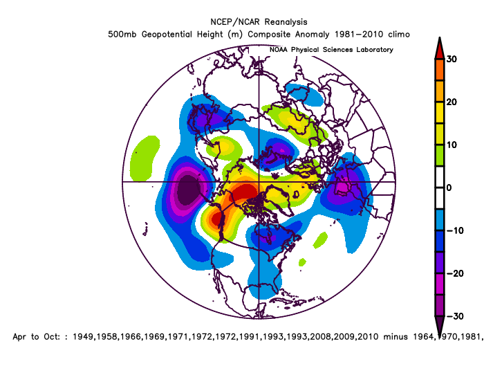
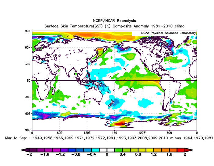
I actually like these analogs going forward
-
2021-2022 ENSO
StormchaserChuck! replied to StormchaserChuck!'s topic in Weather Forecasting and Discussion
Warm pool strengthening in the west.. -
2021 Atlantic Hurricane season
StormchaserChuck! replied to StormchaserChuck!'s topic in Tropical Headquarters
A few GFS ensembles are showing a tropical storm in the GOM long range..

.gif.0a15be490ac6bcef259d07daac979b9b.gif)