StormchaserChuck!
-
Posts
2,274 -
Joined
-
Last visited
Content Type
Profiles
Blogs
Forums
American Weather
Media Demo
Store
Gallery
Everything posted by StormchaserChuck!
-

December 2021 Medium/Long Range Discussion Thread
StormchaserChuck! replied to North Balti Zen's topic in Mid Atlantic
It's a really big -PNA reloading again on Jan 3rd, very strong. How did we do these years. There's actually nothing like Dec 2010 for January Before 1-25-2000 (one of my favorite storms all time), we had a really strong -NAO, +450average for 10 days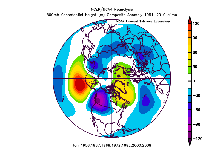
-
December 2021 Medium/Long Range Discussion Thread
StormchaserChuck! replied to North Balti Zen's topic in Mid Atlantic
Actually, the 6z GFS ensembles have a much stronger -NAO though.. strongest 10-15D run so far. We have +300dm as an ensemble mean over the Baffin Island at 384hr. -
The last 21 -NAO's since March 2018 have had no power at all.. I think we are even average to slightly above average temps for that 300 day composite. Every single one has been with -PNA or +EPO, This one's going to do a +4SD -PNA, and probably end near average or above average as well.
-
December 2021 Medium/Long Range Discussion Thread
StormchaserChuck! replied to North Balti Zen's topic in Mid Atlantic
GFS ensembles is reloading/strengthening -NAO at hr384 and it's reloading -PNA too. I think the reloading -PNA at 384hr is good because otherwise we may default quickly to +EPO. -PNA also keeps a lot of cold air in N.America (,but although that it sometimes than true, more times than not ~60% of the time SE ridge amplifies when that is the case). I do think we will see the Pacific shift in January, maybe Jan 5-10, and I mean as much of a flip as is possible with predominant -PNA cycle present. We seem to be in this law of averages-evening out thing, so there may be a +PNA period in Jan. Don't broadbrush the whole thing because it's Nina, just maybe expect less precip, as that has been the trend since the Summer anyway. -
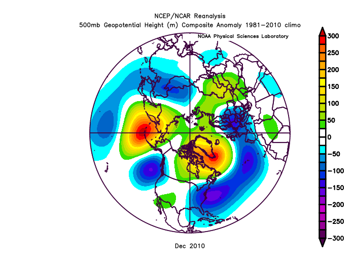
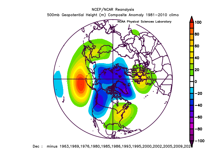
Only -PNA of the magnitude as this December is 2010 Pacific kind of flipped around in January (+300dm Dec 2010 #1.. #2 is 1955 +230dm)


-
December 2021 Medium/Long Range Discussion Thread
StormchaserChuck! replied to North Balti Zen's topic in Mid Atlantic
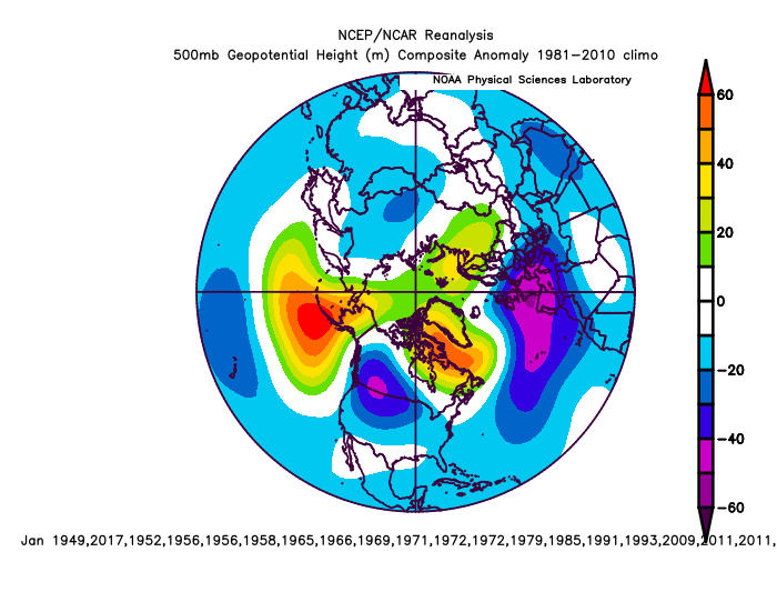
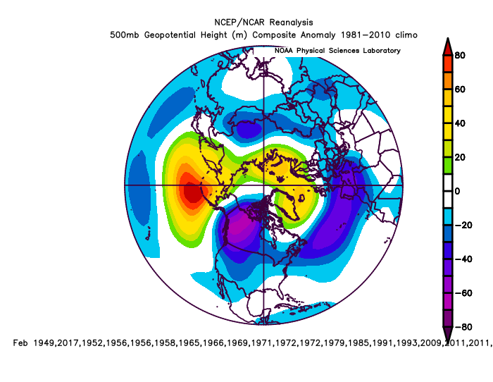
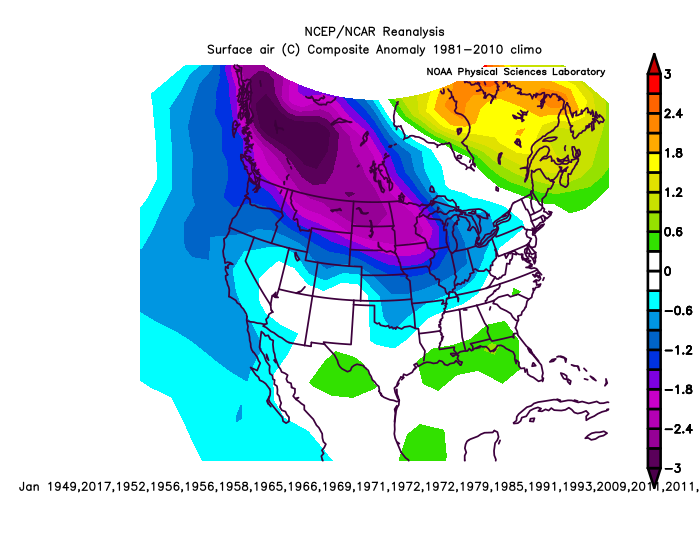
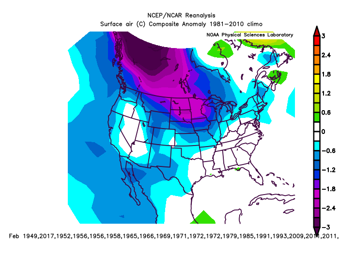
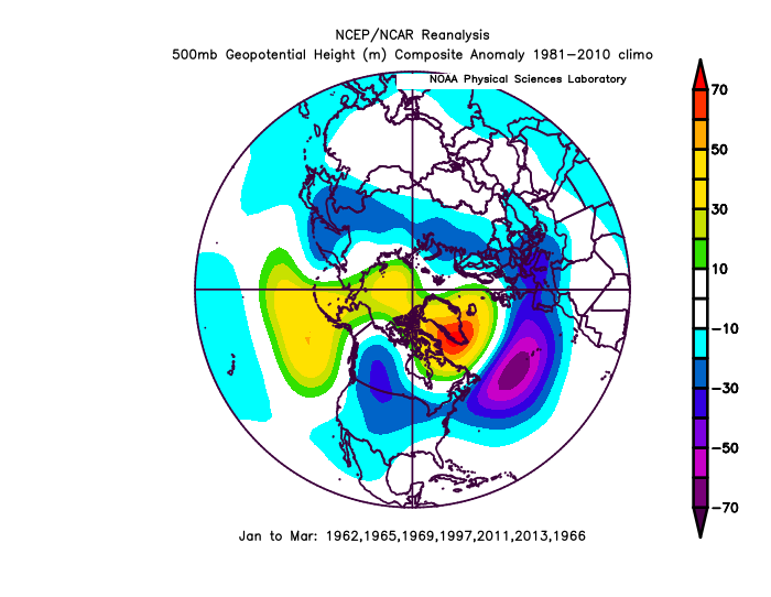
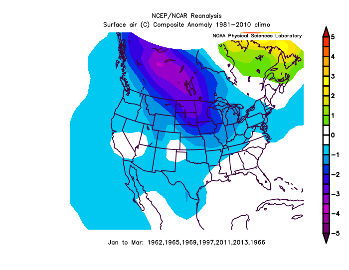
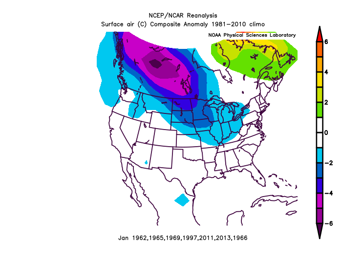
Hey, December 2010 was the most -PNA by a lot, only really comparable to this year since the early 1900s. This was Jan 2011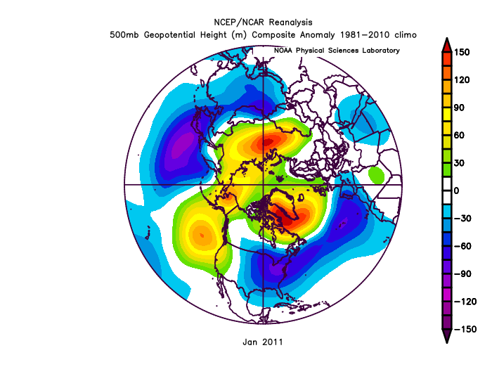
-
2021-2022 ENSO
StormchaserChuck! replied to StormchaserChuck!'s topic in Weather Forecasting and Discussion
Opposite correlation to last year, 15D model
-
2021-2022 ENSO
StormchaserChuck! replied to StormchaserChuck!'s topic in Weather Forecasting and Discussion
In Dec 1995, we had a strong Kelvin Wave "head fake", and also 79-80,, 96-97 was a Strong El Nino 1 year later, but 96-97 was Neutral. 82-83 was also the 2nd strongest El Nino, 2-3 years later fwiw.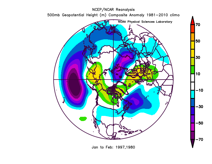
-
2021-2022 ENSO
StormchaserChuck! replied to StormchaserChuck!'s topic in Weather Forecasting and Discussion
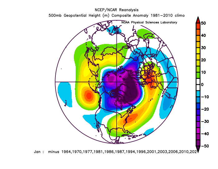
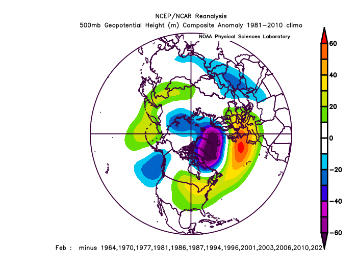
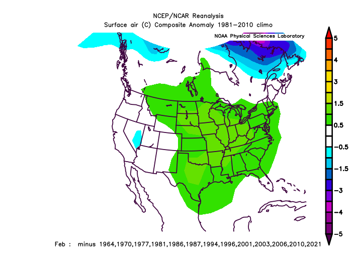
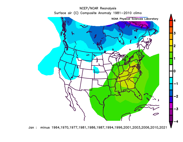
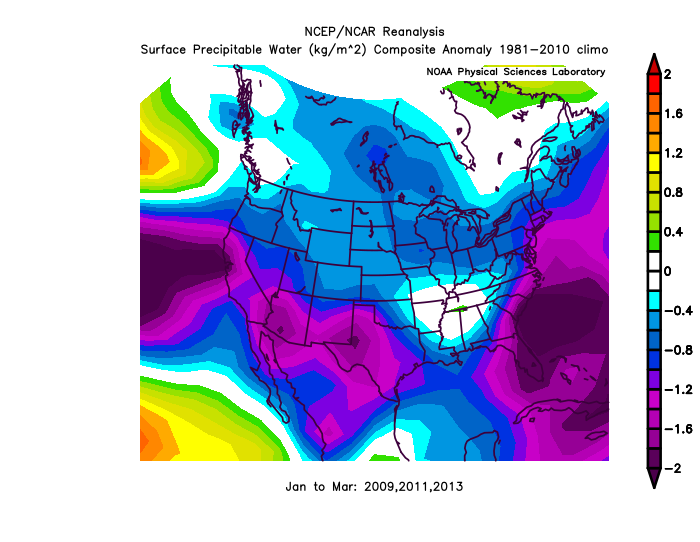
+3 popping up the western subsurface.. ENSO subsurface vs 4-5SD -PNA in December is a -PNA signal for Jan-Feb 2023, and that tends to coincide more with La Nina than El Nino (April-May on). 2010 is the only other year that had such a strong December -PNA (300dm) vs 230dm[2nd], and this is how it evolved. -1.6 2011 -1.4 -1.2 -0.9 -0.7 -0.6 -0.4 -0.5 -0.6 -0.8 -1.0 -1.1 -1.0 2012 -0.9 We will beat 2010 for number 1 this December. -
December 2021 Medium/Long Range Discussion Thread
StormchaserChuck! replied to North Balti Zen's topic in Mid Atlantic
A while back I plotted most extreme -PNA and +PNA times (330+days , and 330+days, since 1948), PNA leads to samePNA out to like 45 days. Less of a signal at 45-60 days. We are so opposite of last year all the time, I'm expecting a Jan-Feb (reverse of 22-23 too) less -PNA (if that makes any sense). -
2021-2022 ENSO
StormchaserChuck! replied to StormchaserChuck!'s topic in Weather Forecasting and Discussion
That's a -PNA signal for Winter 22-23 because ENSO central subsurface is warmer than cold right now vs -PNA (57-59, 65-67, 72-74, 97-99). I'd be impressed if we have an El Nino next year. -
December 2021 Medium/Long Range Discussion Thread
StormchaserChuck! replied to North Balti Zen's topic in Mid Atlantic
Furthermore, El Nino's that missed it, and had a -3SD> December -PNA vs ENSO state include 1957, 65, 72, 97, and the following February (Feb 2023 analog)fwiw -PNA next year maybe. I also mention this because the other 2 times 6th year after Strong El Nino, 7th year broke it(this shows not). ^(for ENSO analogs) subsurface ENSO is Kelvin Wave/warm-neutral now(El Nino slight analog, -PNA is 3-4SDsvsENSO right now: -PNA signal next Jan-Feb)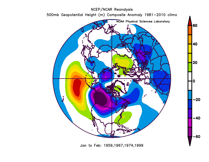
-
December 2021 Medium/Long Range Discussion Thread
StormchaserChuck! replied to North Balti Zen's topic in Mid Atlantic
Top 20 -PNA December's since 1948, 2010 was +300dm, which beat 1955 +230dm for 2nd. 2nd dataset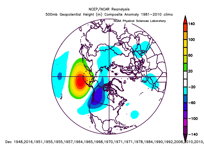
-
December 2021 Medium/Long Range Discussion Thread
StormchaserChuck! replied to North Balti Zen's topic in Mid Atlantic
We are on a streak since the 15-16 Strong El Nino that looks like this compared to the rest (Winter PNA): 6years -170 -120 -115 -112 etc -
December 2021 Medium/Long Range Discussion Thread
StormchaserChuck! replied to North Balti Zen's topic in Mid Atlantic
Might be the strongest -PNA on record for December, 12z GFS ensembles have 2 separate reloads of +640dm and +600dm! Enjoy the pure extremes over weather for the next two weeks.. observe what a High pressure in the Central North Pacific Ocean is like here. -
Whoa! It might be hard for the NAO to go negative late month. The last few runs of GFS ensembles have kind of backed off a little.
-
I was looking at records for 500mb
-
December 2021 Medium/Long Range Discussion Thread
StormchaserChuck! replied to North Balti Zen's topic in Mid Atlantic
Since 1948, PNA <-1 in Dec, with -NAO, 7 years, seems to shift energy to the NAO later, we'll see. (Of course, you know much of this December was +NAO)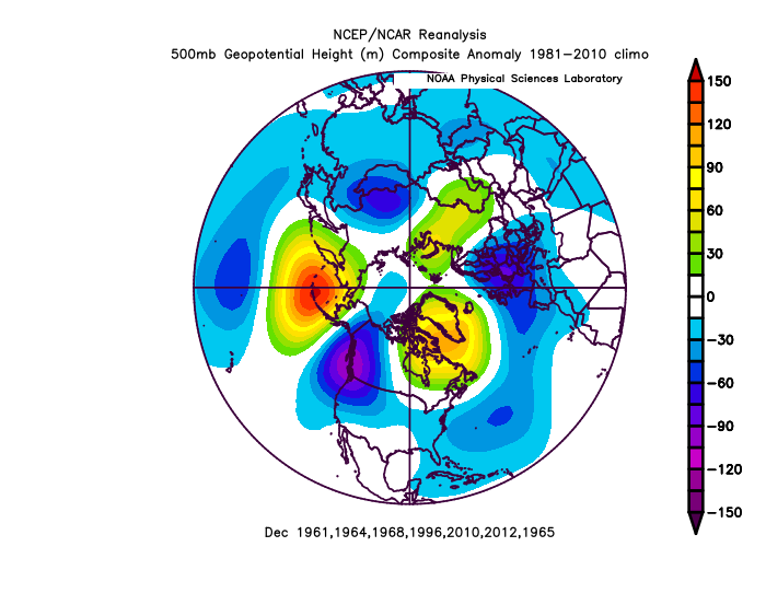
-
December 2021 Medium/Long Range Discussion Thread
StormchaserChuck! replied to North Balti Zen's topic in Mid Atlantic
3 pink 500mb anomaly peaks, 18z GFS ensemble mean: That's 582dm ridge in northern England, to start. 2nd image hits almost+600dm as an ensemble mean average, that's top 10-15 all time (I think I found +720dm over the Arctic as the record).
-
December 2021 Medium/Long Range Discussion Thread
StormchaserChuck! replied to North Balti Zen's topic in Mid Atlantic
La Nina is weakening, and there should be a PNA shift around Jan 15th. It will be hard to do -PNA with that subsurface structure in the 2nd half of Winter. -
December 2021 Medium/Long Range Discussion Thread
StormchaserChuck! replied to North Balti Zen's topic in Mid Atlantic
It's a really good signal for Arctic cold. NAO block could last into January, too, alot of the roll forward stuff from the Spring, Summer and Fall had this. -
December 2021 Medium/Long Range Discussion Thread
StormchaserChuck! replied to North Balti Zen's topic in Mid Atlantic
At 12z, 8/25 GFS ensemble members had the 498dm Polar Vortex over SE Canada, or the NE at 384hr (12-29). -
December 2021 Medium/Long Range Discussion Thread
StormchaserChuck! replied to North Balti Zen's topic in Mid Atlantic
The last 3 times the PNA was <-1.00 in December, the rest of the Winter was -NAO, -PNA, I've seen that these types of things play out in real time vs later. Before then you have to go to the 1990s to have a -PNA December.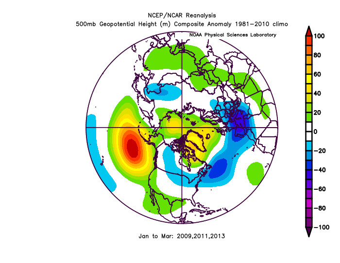
-
December 2021 Medium/Long Range Discussion Thread
StormchaserChuck! replied to North Balti Zen's topic in Mid Atlantic
Honestly, -PNA with strong -NAO is not that bad. We do best snowstorms with GOA Low which is -PDO pattern. Problem is probably the STJ. -360dm on a 372hr average of 25 ensemble member is strong. -
This really isn't bad.. the -PNA it seems reaches up to pour into -WPO and -EPO regions, with a big -NAO, and I think the cycle become wetter this could be a fun time unless it trends back. http://www.meteo.psu.edu/fxg1/ENSHGTAVGNH_12z/ensloopmref.html By 384hr, that's a really solid-NAO, and -WPO seems to be pinching off