

Itstrainingtime
-
Posts
19,625 -
Joined
-
Last visited
Content Type
Profiles
Blogs
Forums
American Weather
Media Demo
Store
Gallery
Posts posted by Itstrainingtime
-
-

We can hope that this 10 day image changes for the better...soon.
-
Just now, paweather said:
Do you see a Pattern in this forecast?
Mostly cloudy, with a high near 40. North wind around 6 mph.TonightPartly cloudy, with a low around 23. North wind around 8 mph.SaturdaySunny, with a high near 40. North wind 8 to 10 mph, with gusts as high as 20 mph.Saturday NightPartly cloudy, with a low around 26. Northwest wind 7 to 9 mph, with gusts as high as 20 mph.SundayMostly sunny, with a high near 41. Northwest wind 6 to 9 mph.Sunday NightPartly cloudy, with a low around 25.MondayMostly sunny, with a high near 42.Monday NightPartly cloudy, with a low around 27.TuesdayMostly sunny, with a high near 42.Tuesday NightPartly cloudy, with a low around 27.WednesdayMostly sunny, with a high near 41.Wednesday NightPartly cloudy, with a low around 27.ThursdayPartly sunny, with a high near 44.You need to move south! Mine has rain/snow for Tuesday.
")
-
 1
1
-
-
4 minutes ago, paweather said:
I guess it is time to move to Texas or the Carolinas for snow.

Western part of North Carolina is a great place for snow - get out west of Wilkesboro and that area averages more snow in the winter than we do. They get upslope, far enough south to get into southern stream action, and far enough west to avoid changeover. My wife wants to retire to Boone - we'll see...
-
MDT finished 2020 with an average temperature of 56.6, which ties 1998 as the warmest year on record in Harrisburg.
-
5 minutes ago, paweather said:
From WGAL:

I've always found it fascinating that Lancaster-based WGAL uses info from Harrisburg and not Lancaster. At least in most of Lanco, 1996 dropped more snow here than 2016 did. The 1983 storm dropped remarkably similar amounts in both locals - I measured 24.8" in the '83 storm. I don't remember 1945.
-
At the very least, it's been a beautiful winter day. So nice to see nothing but blue skies - good for the soul today.
-
As Big Ben of the Steelers would say, the Euro looks like poo.
-
12 minutes ago, MAG5035 said:
It stopped snowing around this time in the afternoon Sunday. It has remained cloudy and literally within a degree or two of 35ºF in the 72 hours since then. I dunno about any of you guys, but I'd actually like to see some sun and clear weather for a couple days.
That's what I was saying earlier. This cloudy weather is somewhat depressing.
-
28 minutes ago, anotherman said:
I think the snow will come. So many years where it looked cold and dry and everyone complained but eventually the snow came. Let’s get the cold air first.
Having established cold is one less thing to be worried about for sure. At the same time, we don't really need "cold" right now - we can swing this with average temps for the next several weeks. In January and the first half of February, I want moisture first and cold second. As long as we don't see cutters the next month or so, I like our chances. Get something under us and we'll likely be happy. If it's too cold, it's likely going to be too dry.
-
8 minutes ago, paweather said:
1996!
Woke up on Saturday morning to a forecast of 2-4". Went to bed that night with a call for 12"+. Woke up Sunday morning and it was 20-30". By afternoon, it was up to 24-36".
Final total = 30.5".
-
 1
1
-
-
1 minute ago, paweather said:
In my mind, January has become the most boring month here. I would love to just track a rain storm in this month if nothing else.
25 years ago today, our weather was anything but boring.
-
I've gone on record here previously stating that I enjoy a nice dark, dreary day - but at some point can we at least have SOME sunshine? We're on a roll lately with cloudy days...
-
44 minutes ago, CarlislePaWx said:
A couple of days ago I woke up to about 0.2" of snow that unexpectedly fell over night. Funny thing is I don't remember which day that was precisely. It was close to the end of the year, but before the 31st. Any idea what day that might have been? Adding in that 0.2" plus the 0.1" from today, that brings my seasonal total to 11.0". (You can see it down at the bottom of my signature.) I was intending to update that prior tiny coating but forgot to, and now I don't remember the day.
I posted my question on my phone and couldn't see your signature. Thank you for responding. I'm sitting at 10.8" so those 2 small events you've had recently has put you on top.
-
1 minute ago, CarlislePaWx said:
Well, so much for the 2 to 3 inches of snow. Those wet snow bombs (which did look amazing) only lasted for maybe 15 minutes tops. It was enough to accumulate about 0.1" with a tiny white coating. Then, it stopped. Then, the rain came back and deposited about another 0.07" of pure liquid. On to the next one.
What is your seasonal total for snowfall to date?
-
18z GFS illustrates my fear from this morning perfectly. Northern stream energy pushes our system out to sea way south of us. Not saying that will happen, but the idea is gaining momentum...
-
All rain here other than a few sleet pellets earlier.
-
Rain. 35 and dark, dank, dreary, drippy, and damp.
-
@showmethesnow great post this morning. Well thought and laid out in a way that is easy to understand. I guess we differ on thought regarding the northern stream impulse- you are correct in saying that it could kill this for us, which is why I said it would need to dig under and phase in. Otherwise, it's game over.
-
 1
1
-
-
46 minutes ago, Blizzard of 93 said:
What are your thoughts on the upcoming storm chances later this week & next week?
I'm casually interested. Right now I'm concerned about both temps and the track. If we can get some northern stream energy to phase in south of our latitude, it's game on. I'm just not convinced that happens, and without it we'll be dealing with either a suppressed system, a warm one, or both.
-
1 hour ago, Mshaffer526 said:
Precip has changed from a sleet/ZR/snow mix to what seems to be all snow as it wraps up. Ground has whitened up nicely, especially on mulch. Unexpected little surprise.
Appreciate the little things!
Had a nice period of sleet here, but no snow. Good for you!
-
1
-
-
8 minutes ago, MAG5035 said:
I upgraded to an iPhone 12 Pro a few weeks ago, it has one heck of a camera system. Really excels at the low light stuff, and also showing we’re still in the thick of the icing phase of this system here.
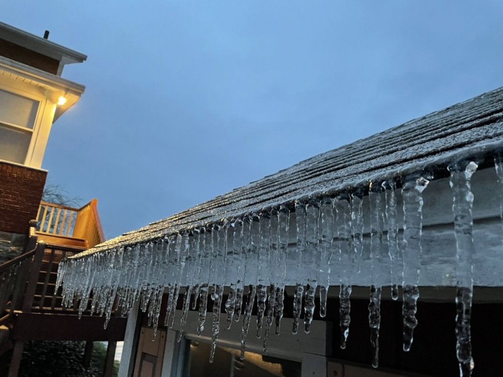
Just bought my wife the same thing for Christmas - I buy her iPhone's specifically for the camera as she loves to take pictures while we're walking. You took some great pics with a great phone.
-
32 and rain here but it isn't freezing on any surface.
-
14 minutes ago, SavageJack said:
Currently sleeting in Hanover.
I've had off and on sleet/rain mix here.
-
@anotherman I agree with you 100% on the post you made in the other thread about the build up and anticipation of a snowstorm. The analogy of Christmas is spot on as well. I enjoy the hunt every bit as much if not more than the storm itself.
-
1
-


Central PA - Winter 2020/2021
in Upstate New York/Pennsylvania
Posted
Thank you for posting that. I always appreciate looking at those maps.