dWave
-
Posts
1,967 -
Joined
-
Last visited
Content Type
Profiles
Blogs
Forums
American Weather
Media Demo
Store
Gallery
Everything posted by dWave
-
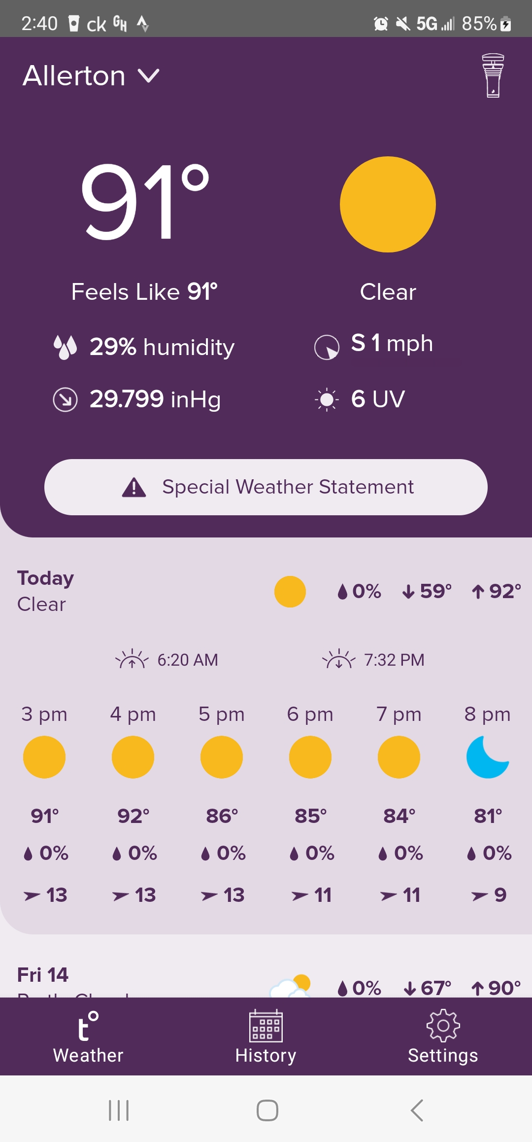
Yeah I got an alert of a flood warning for the Bronx River. There's new buildings right along the river just south of the Zoo, I suspect that's what the E Tremont reference is for. The usual suspects already have closures, Bx River, Saw Mill Pkwy.. https://water.weather.gov/ahps2/hydrograph.php?wfo=okx&gage=bbgn6
-
What's up with this flood advisory? Looks like flash flood warning levels to me. Plenty of flooded streets, stalled out cars and some flooded basements. NWS is slipping
-
2" of rain since yday, light rain still falling.
-
Big range though with the easterly flow. 74 in the Park, 63 at LGA.
-
Yeah I fell 5 degrees the last hr to 88
-
Still rising, 93. How far has the sea breeze reached?
-
Time to wake up the 90 degree day thread..
-
Off to the races, after low of 63, now 79. NWS now forecasting 90
-
Ha...Frost Advisory tonight for Bronx, Staten Island, Nassau and a little of NE NJ 339 PM EDT Sun Apr 2 2023 ... FROST ADVISORY IN EFFECT FROM MIDNIGHT TONIGHT TO 8 AM EDT MONDAY... * WHAT, Temperatures as low as 34 will result in frost formation. * WHERE, In New Jersey, Hudson, Eastern Essex and Eastern Union Counties. In New York, Bronx, Richmond (Staten Island), Northern Nassau and Southern Nassau Counties. * WHEN, From midnight tonight to 8 AM EDT Monday. * IMPACTS, Frost could kill sensitive outdoor vegetation if left uncovered. PRECAUTIONARY/PREPAREDNESS ACTIONS... Take steps now to protect tender plants from the cold.
-
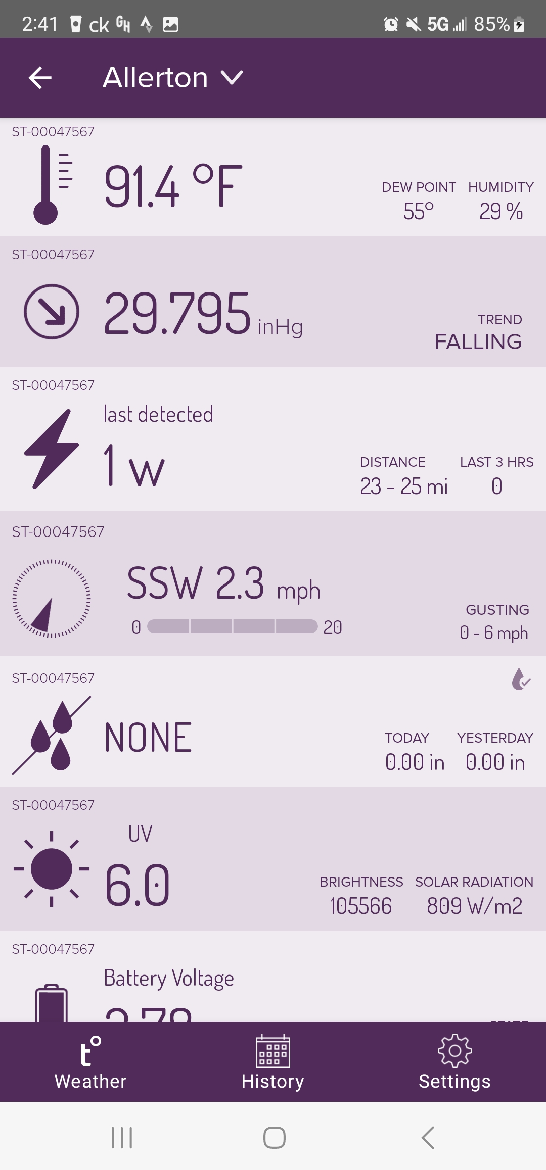
Yeah I'm not a fan of the super low humidity. Its not as bad as yday though. Might be an asthma thing but when humidity gets down to 15% or 10% it feels like breathing knives. There's some brush fires in NJ suspending train service between Penn Station and Trenton
-
Sunny and 64. The bone dry dew point still leaves a little chill to it in the shade or breeze. 12* dp, 15% humidity
-
Nah it was a legit 5"+ snowfall, on pavement and everything even in the 5 boros. It fells mostly overnight. It just didn't very long. The sun came out in the morning and destroyed that snow through out the day. Any piles remaining were gone with record heat in the 80s to end the month.
-
Got a rain snow mix now, on TV I see the more steady wet snow in Manhattan as well as traffic cams approaching GWB. .76" rain here, T snow
-
I havent seen a single flake, not that it would amount to anything anyway. Central Park, EWR, Teterboro reporting snow. LGA, JFK reporting rain.
-
They miss snow sometimes, but there really was basically nothing this time. 0.1" might be generous tbh. Maybe a slushy coating on a few car tops, but snow sticks to cars even easier than grassy surfaces, I don't think of cars as a valid measurement. Even if you did it would just be a tenth or so.
-
There was some around Foley Sq and City Hall. Lots of slush and I could see shoveled snow. In such marginal events the small things make a difference. Like a steam pipe runs under one street and not another. Also high profile locations get super vigilant about snow removal. You need to leave that initial base layer alone to acclumate on top when its above freezing. Plus this was a grassy surfaces type storm. So it'll be winter wonderland in the large parks and look like a rainy day in some actual neighborhoods. At least the other boros have small backyards where it sticks and it can build out from there. Midtown can be even worse than lower Manhattan.
-
7am LGA 2.7" JFK 1.5" EWR ?
-
Looks like a east west gradient. I measured about 2.5", 3" in a few spots. This is near Pelham Pkwy. Drove to New Rochelle and its a little less snow, at least right on the Sound. 1.5" estimate. Heavy and wet to move though might as well be 6"
-
What part of the Bx is that?
-
Yes he did..looks like it too. Maybe an inch. Don't know where they were exactly.
-
I have that too, down side it doesn't detect snow at all. Mine was showing heavy rain too but it really was raining. In the Bx Going back and forth between heavy sleet and rain. Some sleet coatings on cars but melting faster than it can pile up. 36*
-
Driving btwn Co op city bx and New Rochelle, light snow to light snow/sleet mix to a steady rain and sleet now
-
Yup, and you'd need that amount on pavement not grassy surfaces. Just about 0% chance unless it suddenly gets 5 degrees colder. Since it's remote learning they may lower the bar?
-
Yeah, White Plains isn't very good for the Bx or even for some of urban southern Westchester either. HPN isn't actually in the city of White Plains but a wooded area straddling the CT border. The low temps can be a bit colder than downtown White Plains. An offical site at the Zoo would be nice, or NYBG. Bx Zoo does have a PWS (maybe 2). They use it for the zip line/treetop adventure area they have now, and weather conditions are important for operations. From what I've seen it seems pretty accurate. It's very similar to LGA, which is 4 -5 miles due south anyway. Slightly cooler at night sometimes but not significantly so, which makes sense.