dWave
-
Posts
1,967 -
Joined
-
Last visited
Content Type
Profiles
Blogs
Forums
American Weather
Media Demo
Store
Gallery
Everything posted by dWave
-
35 with a freeze warning in effect, but will fall short of a freeze. Still coldest of the season so far.
-
Made it to 78 yday. Riding my bike it was legit hot, had to go back to shorts, but beautiful day with peak fall foliage into NYC now. 64 now, a warm/humid marathon morn. I remember working at Brooklyn half marathon and it was mostly cloudy humid low 70s, many people were handling it terrible.
-
I'm here in the Long Beach desert, the 2nd or 3rd round of t storms going on now. Had the pleasure of nearly getting blown off a bike on the boardwalk in blinding rain, fun times still though.
-
92 here. Central Park got to 90..before LGA at that.
-
8/9 NYC high/lows. Most widespread 100s yet. To there credit NY1 actually used these readings in there weather reporting to show daily real life conditions beyond Central Park. Also noted despite Central Park official records, in reality this was an 8 day heat wave for most in NYC
-
How high can we go

-
This the hottest morning in string of hot morning. 87/75 after low of 82. 3rd straight 80+ low temp. Going for 8th straight 90 today.
-
Not the Sound but I was at Long Beach yday and I have a fitness watch, it measure water temp etc..not of great scientific quality I assume but it was constantly showing low 80s. I've had it touch 80 time to time to time in the water but never just hold steady like that for 45 mins in the water, maintaining and avg 80+. It definetly felt the part. Meanwhile it's 93/77/107
-
Mostly cloudy 82 dew 73, after a low of 80.
-
Hottest day of current stretch once the sun broke through. 95/72/ 103
-
The southern half of NYC is gonna get rain?! Amazing light show in the southern sky
-
Was it forecast today? Anyway..in the Bx, at the track in Pelham Bay Pk it's partly sunny with moderate rain..a few heavier bursts. Home thermometer says rain and 90. Very FL like. High was 93.
-
I didn't realize July had no high temps below 80 at Central Park, and how rare that is. It hasnt happend since the 1940s..forgot the exact year. I did once due to training t storms holding temps down that day. Split 99/66, avg 80 for the month with 12 90 degree days
-
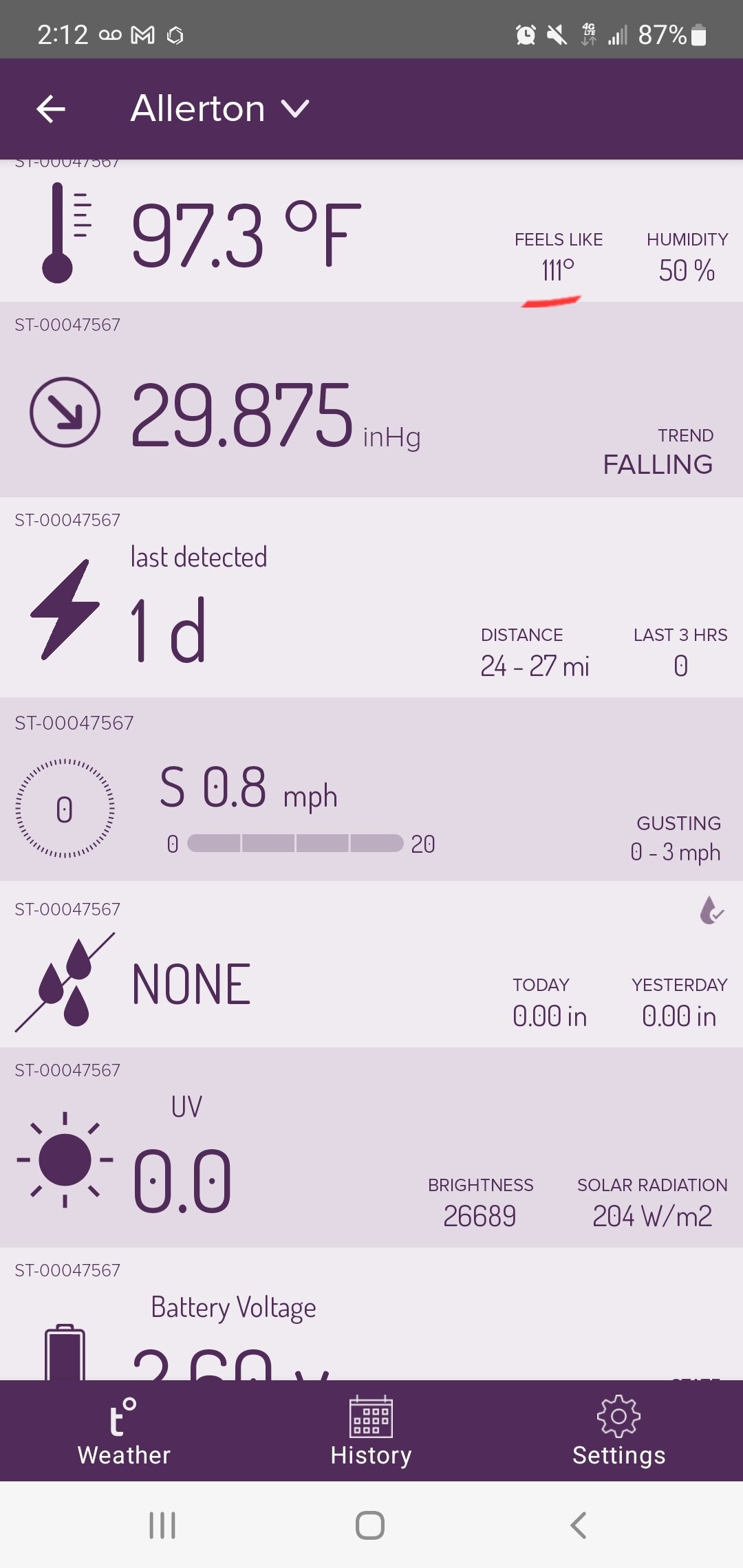
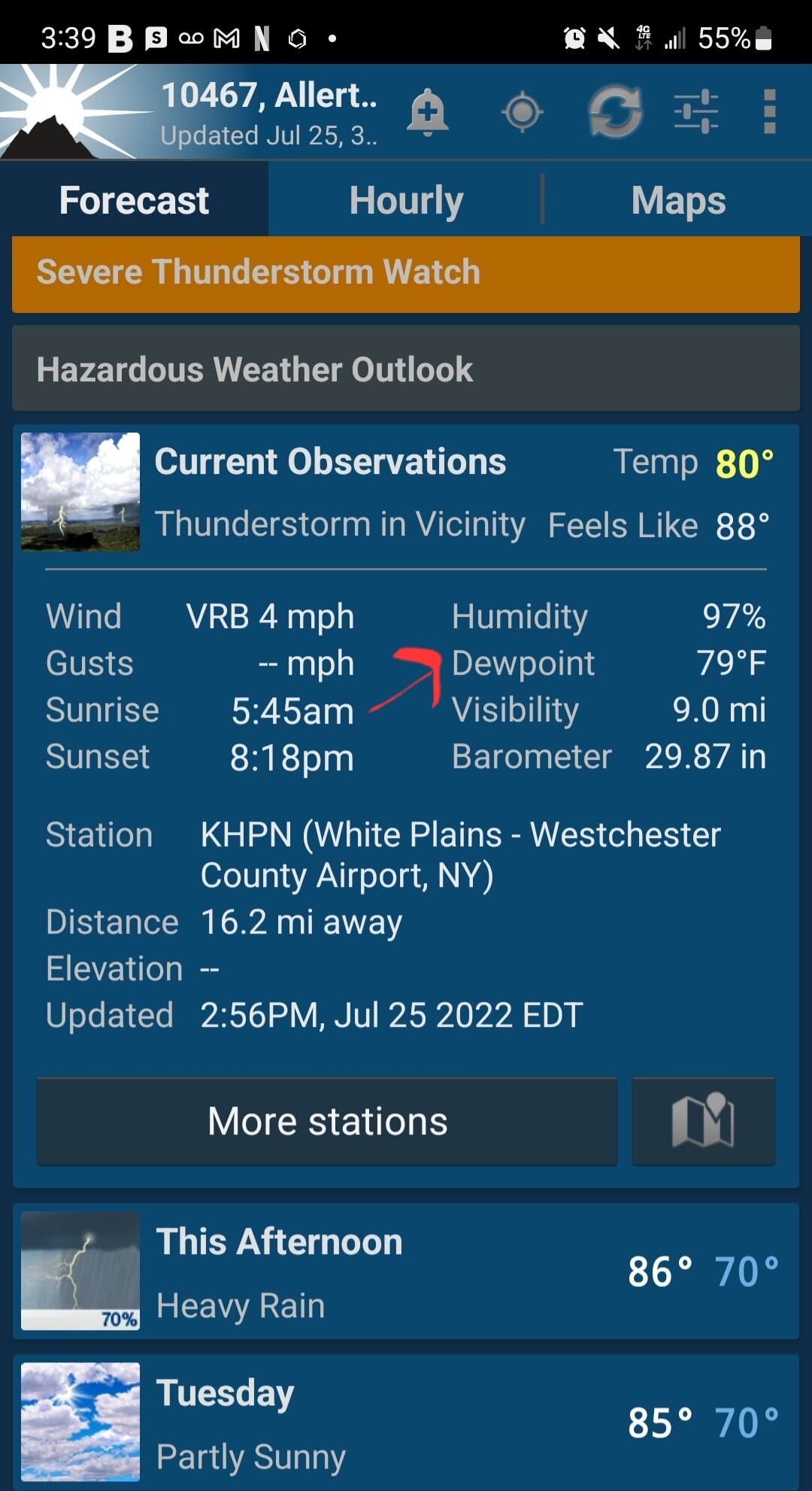
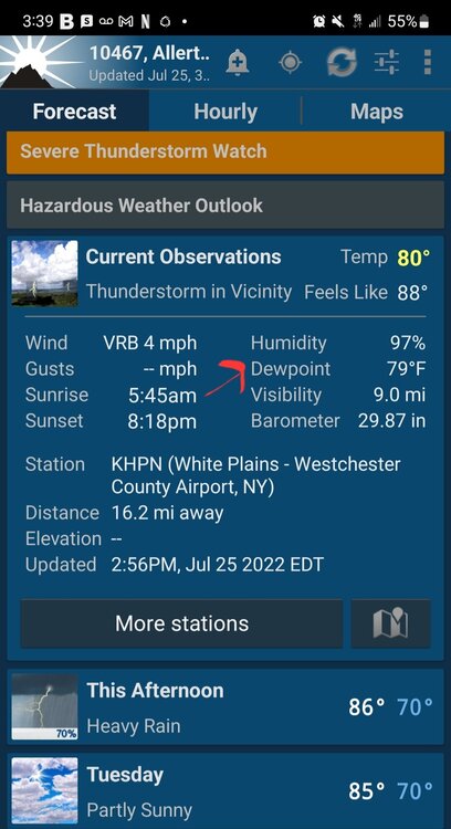
Quite the humidity at HPN. At 3pm White Plains is 80, dewpoint 79
-
Severe t storm warning for NE NJ, Manhattan, Bronx, Queens
-
84/ 75 heat index 92
-
You could of taken the 2 train from drought in Flatbush to times of flash flooding in Wakefield
-
Thought I was making a run at 100, but temps stopped at 98, a few clouds then a gusty S to SW breeze and temps dropped to 94 but dew steadly rising to 70
-
Genuine question..right or wrong, what information excatly from NJClimate is he citing? Or is that just what he heard and everyone should simply accept it?
-
I remember back then going to a city pool in LES. It might as well of been hot soup. Warmest water I ever swam in. I been in upper 80s Gulf water and it was much much warmer than that. Parks dept hosing down the line to get in was the only cool water that day. Hottest experience I could remember until a very humid Aug some years ago. I think that's when JFK had a 84 dewpt.
-
97 and still rising..maybe will top the 98 high for the season from May and 3 days ago.
-
88 after high of 95. Now darkening skies with t storms in the area again
-
Yup despite a falling dew point. The Park just fell below 90 at 10pm. The micronets are all around 90 give or take a couple degrees.
-
Got to 92 then t storms cooled down to 74. 1.5" rain and some flash flooding, then back up to 89, now 87. Dew fell 77 to 68 in the past hr.