

HillsdaleMIWeather
-
Posts
3,560 -
Joined
-
Last visited
Content Type
Profiles
Blogs
Forums
American Weather
Media Demo
Store
Gallery
Posts posted by HillsdaleMIWeather
-
-
Lock in that 3K NAM
-
17 minutes ago, Stebo said:
Also I disagree with what DTX is selling GRR has a much better handle with their AFD. I'm actually surprised DTX is hohum especially since this is going to be coming at night here and everything looks high end.
IWX is even more bullish then DTX for our couple counties
-
Wow, I might actually be in play for this if the trend continues
-
15 hours ago, cyclone77 said:
Not surprised to see the lack of a marginal for parts of Iowa/southern WI/north IL for tomorrow, as forecasters like to stay consistent day to day. Broyles went with a general thunder for those areas for day2, as he had done on day3, which will be a mistake. In subsequent forecasts a marginal will likely be added by a different forecaster. It's possible a slight might eventually be needed as well, as there is sufficient shear and instability for organized severe. Question is just how much of it. Simulated radar from 3km NAM shows some scattered activity. Nice little vort is well timed, and should provide some additional lift. Surface flow looks to remain fairly backed ahead of the front, with fairly decent shear in the lower 3km.
You were right
-
 1
1
-
-
Seeing as yesterday was the first day of Spring officially, and that temps are doing their usual roller coaster, now is good as any time to start the thread.
-
Sun trying it's hardest to come out here right now
-
Majority of the rain is moving off, might actually get some sun after all
-
22 minutes ago, jojo762 said:
00Z 12NAM = pretty good.
Early convection isn’t an issue in this run, resulting in ~1000J/KG CAPE, along with sustantial bulk and low-level shear... I’ll let you imagination do the rest of the thinking there...
00Z 3km NAM = meh.
Tons of morning and early afternoon crapvection across Indiana, Ohio, and Kentucky. As andyhb mentioned, still could be some potential further south, but instability looks pretty mediocre on this run until you get into AL/MS. Any storms in between Indiana and Mississippi would be absolutely torn apart by this level of shear (60-70+ kt 0-6km) with <1000J/KG CAPE. Fwiw, definitely a VBV signature being shown between the 800-600mb layer in the aforementioned southern target, providing questions over storm modes there despite a relatively better environment compared to the northern target.
Still waiting for more guidance but not feeling particularly sure in any one solution at this point. Either going to be a crapfest or an impressive day imo. Leaning more toward crapfest given that HRRR has been sticking toward more of a 00Z 3NAM solution for quite a while (even though the HRRR regularly over does convection).
02 HRRR took a step back in the right direction
-
0Z NAM looks mediocre at first, then supercell city
-
1
-
-
12 minutes ago, BrandonC_TX said:
18z HRRR shows no lack of warmth ahead of the front. There's a lot of SRH shown over the warm sector and mid-60s to lower-70s temperatures with dewpoints modeled in the upper 50s to lower 60s across western and central Ohio. If storm mode can remain discrete (and sufficient cloud breaks occur as previously mentioned) it seems that the potential for tornadoes is there. Looks promising provided that everything comes together just right. That said, the NAM3K is a bit less aggressive with destabilization.
I know the HRRR can be a bit overdone at times, though. It is also showing pockets of high temperatures in the lower 80s over western WV, SW PA, and SE OH, though this area is not under the moist axis (temperatures under the moist axis are generally being modeled in the 60s to near 70 at best). The HRW models and the NAM 3k (the other CAM models available on pivotalweather.com) are at least somewhat consistent on a temperature spike into at least the mid-70s occurring over this region, though.Considering the high res models have the dew points lower than they actually are right now, the higher numbers might happen.
-
Considering a sizable chunk of the subforum is now under a Slight Risk with Enhanced being considered, good time for a thread.
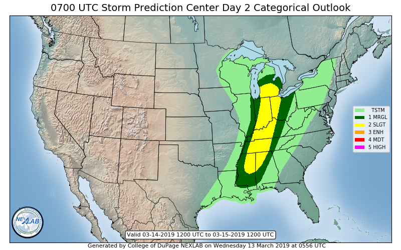
..LOWER OHIO VALLEY VICINITY
A STRONG SOUTH/SOUTHWESTERLY LOW LEVEL JET WILL TRANSPORT GULF MOISTURE FAIRLY FAR NORTHWARD FOR THIS TIME OF YEAR, WITH AT LEAST A NARROW CORRIDOR OF LOW 60S F DEWPOINTS AS FAR NORTH AS THE LOWER OHIO RIVER, AND LOW-TO-MID 50S F DEWPOINTS INTO SOUTHERN MICHIGAN. WHILE THE BETTER QUALITY MOISTURE WILL REMAIN CONFINED TO THE DEEP SOUTH, FORCING FOR ASCENT AND DEEP LAYER SHEAR ARE MUCH MORE IMPRESSIVE FROM THE OHIO VALLEY INTO SOUTHERN MI. ADDITIONALLY, MIDLEVEL LAPSE RATES ARE EXPECTED TO STEEPEN FROM KY/IN INTO MI AS STRONGER HEIGHT FALLS AND COLDER TEMPERATURES ALOFT OVERSPREAD THE REGION AHEAD OF A MIDLEVEL DRYSLOT BY MIDDAY. ALL OF THIS COMBINED LEADS TO A NARROW WARM SECTOR CHARACTERIZED BY 500-1000 J/KG MLCAPE, 6.5-7.5 C/KM MIDLEVEL LAPSE RATES, IMPRESSIVE/LARGE CURVED LOW LEVEL HODOGRAPHS AND 45+ KT EFFECTIVE SHEAR. WHILE THIS PARAMETER SPACE IS MORE THAN CAPABLE OF SUPPORTING WIDESPREAD SEVERE, INCLUDING DAMAGING WINDS AND POSSIBLE STRONG TORNADOES, QUITE A BIT OF UNCERTAINTY STILL EXISTS. THIS IS DUE IN PART TO SEVERAL ROUNDS OF SHOWERS AND THUNDERSTORMS EXPECTED IN THE DAY 1/WED PERIOD, WITH ONGOING CONVECTION POSSIBLE IN WARM ADVECTION REGIME AT THE START OF THE DAY 2/THU PERIOD. IMPACTS OF THIS CONVECTION/RESIDUAL CLOUD COVER ON DESTABILIZATION, AND HOW FAR/QUICKLY THE SURFACE COLD FRONT PROGRESSES BY THURSDAY MORNING MAKES FOR A QUITE CONDITIONAL SCENARIO. AS A RESULT, HAVE OPTED TO EXPAND THE SLIGHT RISK NORTHWARD ACROSS THE MID-SOUTH INTO SOUTHERN MI. UNCERTAINTY AND CONDITIONAL NATURE OF THE THREAT WILL PRECLUDE HIGHER PROBS AT THIS TIME ACROSS PARTS OF KY/IN/MI/OH, BUT POTENTIAL CERTAINLY EXISTS FOR A HIGHER-END THREAT TO MATERIALIZE ACROSS THIS REGION, AS IMPLIED BY VARIOUS CAMS IN THE 18-00Z TIME FRAME. OBSERVATIONAL AND NUMERICAL GUIDANCE TRENDS WILL BE MONITORED CLOSELY.
-
39 minutes ago, Jackstraw said:
NE IN, NW OH, far SEMI may be getting the worse of the ice overnight, possible 1 inch amounts. Nice moisture plume should over run the area in the next 4-6 hours with sub freezing surface temps. I'd be real concerned for some severe icing in those areas.
Agreed, ice and winds are picking up here
-
IWX upgraded a few more as well
-
Went from nothing straight to freezing rain here
-
 1
1
-
-
IWX upgraded my county only. I promise I didn't take over the computer lol
-
 1
1
-
-
Toledo has been upgraded to an Ice Storm Warning
-
IWX, GRR, DTX, and CLE considering Ice Storm Warning upgrades
-
GEM nails Southern MI, GFS is rain
-
18Z GFS is a touch north
-
1 hour ago, Frog Town said:
Is the nam to be taken seriously in NW OH/SE MI? I know a lot of that is freezing rain/sleet but something else is going on now, 3 runs in a row.
The other models give us a good amount, the NAM wants to knock out our power
-
44 minutes ago, Stebo said:
Already down to 30/25. So DTX thinking we hover around 30 is looking to be wrong as we have gone from 37/29 to 30/25 in just 3 1/2 hours.
Same here, down to 33, wondering if this event might give us lots with no advisory
-
IWX waiting and seeing for any headlines for Hillsdale, Branch and Williams
-
 1
1
-
-
Super tough forecast for my county lol
-
3 hours ago, Chinook said:
Hmm. The NAM-3km and the GFS both have over 0.25" of ice accumulation for Toledo, but, as of yet, there has been no W.W.A. or W.S.W. issued for the southern tier of counties in Michigan or I-80 tier of counties in Indiana and Ohio. Maybe they are holding off due to uncertainty in impact, possible temperatures above freezing.
IWX says they're not planning to issue ANY headlines
April 27-28 Potentially Historic Super Late Season Winter Storm
in Lakes/Ohio Valley
Posted
GFS wants to bury me lol