

HillsdaleMIWeather
-
Posts
3,722 -
Joined
-
Last visited
Content Type
Profiles
Blogs
Forums
American Weather
Media Demo
Store
Gallery
Posts posted by HillsdaleMIWeather
-
-
Absolutely ripping right now, think those higher totals might verify
-
17 minutes ago, Stebo said:
RGEM drops almost 10 for most of Metro Detroit

At this rate of model uptick still, we'll all hit a foot by 12Z while it's falling
-
 1
1
-
-
lol at the GFS continuing to up the totals every run
-
4 minutes ago, Stebo said:
They put one out.
Yeah spoke too soon based on the AFD lol
-
 1
1
-
-
IWX is opting for no advisory at all right now
-
1
-
-
12Z GFS continues to tick up the QPF and accums
-
1
-
-
12Z NAM DUMPS on Southern MI
-
1 hour ago, Stebo said:
Their AFD is a bit light though same with GRR. Only talking 2-4" synoptic snow, I hope they don't get too caught up in climo and ignore the atmosphere itself.
IWX's is a little bit more open to higher total then both of there's, saying they'll have to make more changes if trends hold
-
1
-
-
DTX issued a watch for the Thumb
-
-
0Z GEM holds steady though and clobbers SE Michigan
-
GEM gets it decently inland
-
0Z GFS is clipper city
-
Coming down decently now
-
Changed over about 20 mins ago
-
18Z GFS back west and a couple mb stronger
-
BULLETIN
Hurricane Pablo Advisory Number   9
NWS National Hurricane Center Miami FL       AL182019
500 PM AST Sun Oct 27 2019

...PABLO STRENGTHENS A LITTLE MORE BUT IS EXPECTED TO WEAKEN SOON...


SUMMARY OF 500 PM AST...2100 UTC...INFORMATION
----------------------------------------------
LOCATION...44.7N 17.2W
ABOUT 650 MI...1050 KM NE OF LAJES AIR BASE IN THE AZORES
MAXIMUM SUSTAINED WINDS...80 MPH...130 KM/H
PRESENT MOVEMENT...NNE OR 20 DEGREES AT 25 MPH...41 KM/H
MINIMUM CENTRAL PRESSURE...977 MB...28.85 INCHES
-
1 hour ago, Malacka11 said:
It is unexpectedly silent in here considering the casually optimistic eastern trends in some of the models this last run...
Yeah lol, that CMC run gives me like 5 inches
-
2
-
-
Runs have been seemingly trending more and more that the back end might thump Lower Michigan decently
-
54 minutes ago, Chicago Storm said:
Long track of high winds and wind damage along the track of the COC of Olga.
Still not sure why things are being treated as severe t’storms though.

.
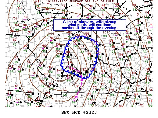
It also just earned a MD too lol
-
 1
1
-
-
0Z GFS slightly weaker and west
-
18Z GFS now has a weak system instead of no system at all
-
10 hours ago, Hoosier said:
After slowing down on earlier runs, the models have sped up the front a bit in the past couple days.
Instability continues to look like it will be on the lower end. The modeled temps/dews (dews in the low to mid 60s) would be good enough for a decent amount of severe wx in a lot of setups at this time of year, but overall CAPE is limited by those meager lapse rates. The better mid level flow also lags behind by more than I'd like to see, especially given the aforementioned problem with instability. I was surprised to not even see a token 5% area on the day 3 outlook though.
Still nothing on Day 2, IWX is mentioning bowing segments though
-
Could be multiple chances for severe weather later this week

Nov. 10-11th snow event thing
in Lakes/Ohio Valley
Posted
Considering IWX raised the point forecast here to 3 to 7 at noon, surprised they didn't as well