

HillsdaleMIWeather
-
Posts
3,560 -
Joined
-
Last visited
Content Type
Profiles
Blogs
Forums
American Weather
Media Demo
Store
Gallery
Posts posted by HillsdaleMIWeather
-
-
12Z NAM looking more like the 0/6Z GFS so far
-
1 hour ago, Hoosier said:
The 6z NAM actually looks like it increased ice amounts in N IL. Very concerning because a lot could be lost to runoff but it would still end up being a big deal in tandem with the wind.
IWX pointing out that the NAM is bad for ice throughout their northern CWA, the just above ground temps are below freezing
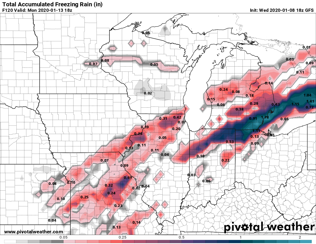
Have favored the cooler models for the shallow cold air Saturday
that originally included just the GFS, but now the NAM is showing
a very shallow layer of cold air just above the surface that will
likely be below freezing for several hours. Believe the greatest
winter weather impact if the surface temperatures are cold enough
will be from freezing rain. NAM BUFKIT 00Z and 06Z runs showed
several hours of freezing rain Saturday into Saturday night. After
coordination with Chicago and Grand Rapids NWS offices have
greatly increased ice amounts. Given the strong upper level system
just reaching the Calif coast, concern that upper level sampling
of this system may still be lacking, so confidence was not high
enough to post a winter storm watch for ice. Otherwise, Sunday
will be dry with highs in the 30s. Travel late Saturday and Saturday
night may become hazardous depending on weather types and pavement
temperatures.
-
1 minute ago, Moosey2323 said:
In terms of headlines, would any watches go out tomorrow? Or Friday?
I'd guess Friday, way too much uncertainty
-
16 minutes ago, Snowstorms said:
The 00z CMC is mostly rain in Chicago and Detroit. The ice line is bit further north than the GFS/NAM, but YYZ gets a significant ice storm.
Eastern Iowa is the winner.
Ice line is further south then 12Z. Literally going to be a thread the needle event with the changing models
-
 2
2
-
-
This is one of those "unlikely but holy shit if it happened" runs
Nearly 2 inches of ice in Southern Lower and Northern IN, with ice still falling
.thumb.png.59182799bf6c0cf43152aedb461d540b.png)
-
 1
1
-
-
17 minutes ago, Stebo said:
Oof that is a shitload of ice/sleet on the GFS for DTX's CWA.
GRR, DTX and IWX's MI counties get blown up with ice on this run
-
-
GFS wrecks southern MI, heavy ice followed by heavy snow + wind would be mass power outages
-
53 minutes ago, Hoosier said:
It's been pretty bad. Haven't even had a 3" snowfall yet. At least my total to date finally broke 6"
That one 9in in November storm is feeling like it'll be the only big one. Knowing our luck, winter will only show up in like late Feburary and March again if at all
-
1
-
-
Honestly close to punting on this winter
-
Snow has been off and on all evening, real fun stuff starts overnight
-
2
-
-
Looks to be a much warmer than normal start to this year/decade, with rain. Rest of the month is less certain after that, will it be a complete torch or will we get some actual snow?
-
GFS finally has fantasy range storms back
-
1
-
-
 RR
RR
Hope y'all like rain!
-
1
-
 1
1
-
1
-
-
0Z GFS hinting at a system towards the end of the month
-
9 inches reported in Moscow in Northern Hillsdale County
So yeah, a WSW would've verified lol
-
 1
1
-
-
7.5 inches here
-
1
-
-
11 minutes ago, nwohweather said:
Oh absolutely. The tilt to this thing with that jet streak is providing plenty of forcing, anyone solidly in the band is going to see some serious totals. I really was shocked most didn't go WSW, especially with it being early season and mid weekday storm. Very dynamic system that can also pull from some warm water on the lakes, should be a solid hit
Considering IWX raised the point forecast here to 3 to 7 at noon, surprised they didn't as well
-
1
-
-
Absolutely ripping right now, think those higher totals might verify
-
17 minutes ago, Stebo said:
RGEM drops almost 10 for most of Metro Detroit

At this rate of model uptick still, we'll all hit a foot by 12Z while it's falling
-
1
-
-
lol at the GFS continuing to up the totals every run
-
4 minutes ago, Stebo said:
They put one out.
Yeah spoke too soon based on the AFD lol
-
1
-
-
IWX is opting for no advisory at all right now
-
1
-
-
12Z GFS continues to tick up the QPF and accums
-
1
-
.png.cabade40248e6ec6f028960750973322.png)
January 10th-12th Winter Storm Potential
in Lakes/Ohio Valley
Posted
GFS pouring freezing rain at 54