

gymengineer
-
Posts
3,242 -
Joined
-
Last visited
Content Type
Profiles
Blogs
Forums
American Weather
Media Demo
Store
Gallery
Posts posted by gymengineer
-
-
I’m following a curated meteorologist twitter list for Dorian. I’ve never seen meteorologists rage tweeting like right now.
-
 3
3
-
-
Of course, adjust your grading if any late March/April events come about. I figured this is a good week to get this thread started. Thanks for starting this thread in the past seasons, @WxWatcher007
2018-2019: I can’t grade it lower than a B. (I tried given how unhappy the mood was generally in here.) The January event was wrapped in positive outcomes during the lead-up and actual event, making it better for me than, say, 2/12-13/14. Saturday morning (1/12/19), just hours before the onset, was great as the model consensus finally resembled the NAM-esque QPF’s, and we got the upgrade to a Winter Storm Warning for 5-10”. I was already very pleased that the warning verified when I woke up Sunday morning. Not banking on the second half, I went outside to enjoy what had fallen. And then came the best conditions since 2016 for the rest of the afternoon into the evening. Another big plus for me was how the November event maxed out and way exceeded expectations for road accumulations. Add in the late February event that had no problems coating main roads in daytime, and I know I’ll always look back fondly on this season.
Below are my winter ratings for the past 25 seasons. Priority is always given to impact. Snow days refers to the number of days Montgomery County Public Schools closed.
09/10= A+ 78.5"; 1) 26.5" (2/5-6/10) 2) 21" (12/18-19/09) 3) 13.5" (2/9-10/10); 9 snow days; this winter clearly stands out as the top I've ever experienced, and since it's a level superior to 95/96 and 02/03, I put those as A's.
95/96= A 65"; 1) 25" (1/6-8/96) 2) 8" (2/16/96) 3) 7-1/4" (2/2-3/96); 9 snow days
02/03= A 53"; 1) 21" (2/16-18/03) 2) 6.5" (2/6-7/03) 3) 6-1/4" (12/5/02); 10 snow days
13/14= A- 52.5"; 1) 15.5" (2/12-13/14) 2) 9" (3/16-17/14) 3) 6.5" (1/21/14); 10 snow days; only thing that knocked this down a notch to an A- for me vs. an A is that it didn't have that one 20"+ storm that closed schools for a week
14/15= B+ 32-1/4"; 1) 7-1/4" (2/21/15) 2) 7" (3/5/15) 3) 3-3/4" (1/6/15); 7 snow days; historic February cold
15/16= B+ 34-3/4"; 1) 29" (1/22-23/16) 2) 2-3/4" (2/14-15/16) 3) 2" (3/3-4"); 7 snow days; I had this season as a B originally but I knew it was likely the more the years go by, the more favorably I’ll look back at the 1/20-1/27 window.
92/93= B 25"; 1) 13.5" (3/13/93) 2) 3" (2/21/93) 3) 3" (2/26/93); 4 snow days
93/94= B 20.5"; 1) 5" (3/1-2/94) 2) 3" (1/20/94) 3) 3" (12/28/93); 11 snow (mostly ice) days (!)
18/19= B 25.7”; 1) 11.5” (1/12-13/19) 2) 4.8” (2/20/19) 3) 2” (11/15/18); 4 snow days; January event was spectacular and I had my best November event since 1995; 6th snowiest winter in 25 seasons
99/00= C+ 22"; 1) 9" (1/25/00) 2) 5.5" (1/21/00) 3) 4.5" (1/29/00); 4 snow days
98/99= C 21.5"; 1) 8.5" (3/9/99) 2) 4.5" (3/14-15/99) 3) 3-3/4" (1/8/99); 5 snow days
04/05= C 20"; tied 1) 4.5" (2/24/05 and 2/28/05) 3) 3-3/4" (1/22/05); 3 snow days
05/06= C 23"; 1) 14" (2/11-12/06) 2) 3-3/4" (12/5-6/05) 3) 2.5" (12/9/05); 2 snow days
06/07= C 14.5"; 1) 5" (2/25/07) 2) 3.5" sleet (2/13-14/07) 3) 1.5" LOL (1/21/07); 4 snow days; the 3-in-a-row snow days for the sleet storm as well as the very cold and active February lifted this winter up to a "C" despite the well-below average snow total
03/04= C- 19"; 1) 7.5" (12/5-6/03) 2) 6" (1/25-26/04) 3) 4" (12/14/03); 4 snow days (2 for ZR in February) + 3 for Hurricane Isabel
10/11= C- 15"; 1) 8.5" (1/26/11); 3 snow days in a row
94/95= D+ 12.5"; 1) 6.5" (2/3-4/95) 2) 4" (1/28/95); 1 snow day in March
17/18= D+ 11.3”; 1) 3.8” (3/21/18) 2) 3” (12/9/17); 5 closing days! This winter got a bump up to a D+ vs. a D because of the impact although the two closings in January were the wimpiest closings I can remember for ~1” across the county; first ever closing for blue-sky-winds with the March windstorm.
96/97= D 14.5"; 1) 6.5" (2/8/97)
00/01= D- 12-1/4"; 1) 3.5" (12/19/00)
07/08= D- 8-3/4"; 1) 4.5" (1/17/08); only thing saving this winter from an F is I did have two 4"+ snows
08/09= D- 8.5"; 1) 6.5" (3/1-2/09); only thing saving this winter from an F is I did have a 6"+ storm
12/13= D- 10"; 1) 4" (3/25/13 LOL)
16/17= D- 6.5”; 1) 4” (3/13-14/17); 1 snow day for the March snow/sleet event, which held a solid snow cover for four 12Z measurements
97/98= F 3"
01/02= F 2.5"
11/12= F 2"
-
3
-
 1
1
-
-
3 minutes ago, WinterWxLuvr said:
Lol, people posting pictures at night. Yes, snow can and will stick to roads in March, but to act like there’s no difference due to sun angle is just plain silly. Anything remotely dark is sitting there absorbing radiation during the daylight hours at amuch higher rate than in Dec/Jan. Because of that you have to have good rates and/or cold temps to get/keep roads snow covered. You get light snow and 30 degrees in Jan and you will get/keep snow cover on hard surfaces, easy, even during daylight hours. March, not likely. So anybody saying that sun angle doesn’t matter isn’t being truthful. We all know it matters. It’s not prohibitive, but it matters.
Did anyone say any of that in this thread? Of course sun angle matters. Of course it takes more positive factors for snow to stick on roads in March. The point is that it’s not unusual or particularly difficult for snow to stick to roads during the daytime in March. It doesn’t even have to snow all that hard if it’s cold like on 3/2/14.
-
2
-
-
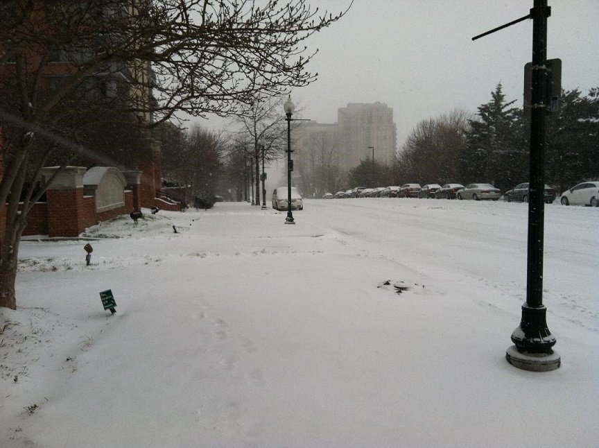
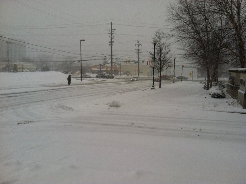
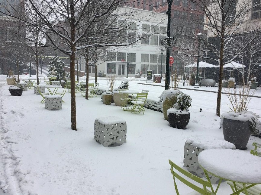
This is a simple thread. Please just post pictures of March snows in our subforum that had no trouble sticking to the road during daylight hours.
My three contributions below are all cellphone pics, so they're pretty crappy in quality. But the point is that I had zero difficulty finding pics in my phone of March daytime snows sticking to roads.
March 3, 2014
March 5, 2015
March 21, 2018
-
3
-
-
2 hours ago, WxWatcher007 said:
@EastCoast NPZ thanks for letting me have a little fun with you. I just found out a few hours ago that the mom of one of my best friends has a few days to live. Cancer. I’m taking it pretty hard.
My best friend’s mom passed away yesterday morning from cancer. The end was very rapid. I just had dinner with her (my best friend) and we cried and laughed and sat in silence....on repeat. I miss her mom. Cancer really sucks.
-
 7
7
-
-
8 minutes ago, nw baltimore wx said:
I'm too lazy to look but I wonder how bwi stacks up.
13th out of 30 seasons, based on a quick count. I may be off by one.
-
1
-
-
3 hours ago, nj2va said:
11/15 1.9”
1/12-1/13 9.8”
1/17-1/18 1.2”
1/29: 0.3”
2/1: 1” (based on nearby reports)
2/20: 3.4"
total 17.6”
Hit climo! Winter automatically gets at least a B.
Someone pointed out this is already for DCA- if there’s not even a flurry for the rest of the season, it’s already DCA’s 7th highest seasonal snow total for the past 30 seasons. 7th out of 30!
For IAD, it’s already the 9th highest seasonal total out of the last 30.
-
2
-
-
29 minutes ago, leesburg 04 said:
If we don't get anymore events I'd give this winter a solid D+ ...decent totals but the snow melted and that stinks
How come people still can't tell what you're communicating by this kind of post? In the observation thread too....
")
-
 2
2
-
-
5 minutes ago, BaltimoreWxGuy said:
Honestly I do not think dry air is that big of an issue on this one. I think it is more about the trajectory of the heavy precipitation. That mostly goes well to our north west into the Ohio Valley And West PA. So basically I think the precipitation coming our way kind of Is getting sheared out and getting weaker as it comes Northeast. At least that’s how the models see it to a degree
0Z models do not show that so far. Don’t look at the snow maps— just look at precip total maps through 18Z tomorrow. The aim of the heaviest precip is not where you described.
-
1
-
-
Just now, LeesburgWx said:
Everyone is just assuming the euro is right all of a sudden? I feel like everyone has given up hope in the last 30 minutes
Certainly not everyone. Just the people whose only contribution in the past few pages is to react to one single snow map...
-
A significant part of this subforum is well above season-to-date snow climo (IAD is 8" above, DCA is 5" above) while a significant part is below. That's not that common for our subforum and it's all because the DC metro area got that small-footprint 10" snowstorm in January. I don't care as much what the pattern shows moving forward as I just have this vague optimistic feeling we will see more snow, much like how I was pleasantly amused with how this past week turned out. I know for someone waiting for the big event, the perspective would be understandably different and the pattern hunt is more important.
-
1 hour ago, WxUSAF said:
Who knows what Feb and Smarch bring, but there’s definitely a chance that this winter is remembered as a ratter for most on the EC. It’s also quite possible I’m over 18” by Friday with 5-6 weeks left of reasonable snow climo. Not going to be a ratter for me even if ends up being less than our November weenie dreams.
Remember the percent of seasonal snowfall average map from the end of last season when the DC area was literally the biggest screw zone for the entire east coast?
DCA is 5” ahead of season-to-date climo and has a shot to surpass its total seasonal snow average on Friday, the first day of February. We’re in the inverse of last season.
-
3
-
-
The 13/14 winter was just insane for the amount of events. Here's my event log from that winter:
12/8-9/13: 1.5” snow to accumulating sleet to freezing rain (>.1” glaze)
12/10/13: 2” slop that had trouble accumulating during the day
1/2-3/14: 4” overachiever, lasting past midnight. Street accumulation on Old Georgetown after dark
1/10/14: Ice on sidewalks from rain in above freezing air temps
1/21/14: 6.5” Biggest storm in 3 seasons—road accumulations even onto Rockville Pike. 5-8” MoCo range
1/29/14: 0.5” overnight
2/4-5/14: ~0.2” glaze of ice. Severe ice storm in Frederick through Carroll and northern Baltimore counties-- >40% power outages.
2/9/14: 0.5” Sunday snow
2/12-13/14: ~15.5” total—13” by 8 am, Rockville Pike completely snow covered at 6 am—drizzle/light rain lull until 3 pm. ULL dropped 2.5” very wet snow that stuck to streets again. 12-20” MoCo range
2/18/14: a bit less than 1” overnight
2/25/14: a bit more than 1” between 9 am and noon—grass and car and Harris Teeter sidewalk only
2/26/14: 2 ¼” between 5:15 am and around 10:30 am.
3/3/14: 5 ¼” after a changeover from rain and sleet by 5 am. Temps dropping through to the lower 20’s by dawn to the teens by noon. Road coverage complete all around my building and in parking lot across the street (plow couldn’t keep up with the snow). Heaviest/lowest visibility band was the last one that swept through between 12:10 pm and 1:00 pm. As temps plunged down into the single digits, any road not completely plowed turned into a sheet of solid ice. 4-7” MoCo range
3/16-17/14: 9”, less on roads. All roads covered overnight in heavy snow with plunging temps, down to low 20’s by dawn. 7-10” MoCo range
3/25/14: 2 ¾”, no road accumulations, but covered bbq patio paved area. Started around 8 am, ended around 7:30 pm.
3/30/14: ¾” surprise heavy snow dumping as fast as it melted to keep on some concrete surfaces.
4/15/14: T-0.1” end squall of sleet to snow after heavy rain
Monthly totals:
December- 3.5”
January- 11”
February- 20.25”
March- 17.75”
Total: 52.5”
-
1
-
2
-
-
It can’t be a bad sign heading into an even better pattern that the two serviceable windows this season have so efficiently given our subforum two 10”+ snowstorms. Richmond wasn’t locked in for their 11” heading into the event either. These are some juiced up storms.
-
3
-
-
There's something kind of fascinating about a Potomac River basin-wide flooding event in mid-December. Now moderate main-stem river flooding is forecast, which is a fitting way of breaking the all-time precip record. If next weekend's rainstorm verifies, then it's an even more fitting way of ending 2018.
-
18 minutes ago, WxWatcher007 said:
Great to hear from you. How have you been?
Thanks for asking. It goes without saying that I was occupied all summer and into early fall when I had resigned from my previous 15-year-long position without another job lined up. But, doing it that way still was the best for my former coworkers and school so they didn't have to replace me during the second month of the new school year. I am now the Head of Education of a company that creates distance learning and online courses for child care providers. It's a great fit for my skill set, and my 9-5 is much less stressful than before. Plus I got a salary boost and I'm applying my management skills as I run a department.
How're you doing?
-
1
-
-
This current burst of historic events--16"+ at DCA, 20"+ for the N and W suburbs--from 1996 onward has actually been spaced out across the months that cover meteorological winter. In my back yard, for example, here are all the 20"+ snowstorms from 1996 onward, slotted into a half-month window:
Dec 16-31: 12/18-19/09
Jan 1-15: 1/6-8/96
Jan 16-31: 1/22-23/16
Feb 1-14: 2/5-6/10
Feb 15-28: 2/15-18/03
There's only *one* remaining half-month period of meteorological winter where DCA hasn't seen a 16"+ storm and I haven't seen a 20"+ storm- December 1-15. I'm definitely not saying it's going to happen this year. But of course I'd love to see that last window get filled in soon by a big one.
-
7
-
-
2 hours ago, Bob Chill said:
And to your last point... yep, we've been on a helluva big storm heater since 02-03. It either means that climate warming supports bigger storms or we regress to the mean over the coming decade or 2.
Have you seen Ian’s recent article about the decreasing averages but increase in huge events?
-
1
-
-
I think this event- the Friday night tornadoes- is going to hold up years from now as one of the most important weather stories of the decade for our region, especially with the lack of tornado warnings. It's been a big deal for a long time now to have fatalities fall outside a tornado warning anywhere in the country. (I get that this news has just been drowned out by everything else that's going on.)
-
1
-
-
Was the La Plata tornado in 2002 really the last fatal MD tornado?
-
Just came across this from Typhoon Jebi. The Hong Kong videos earlier this season got a lot of attention, but this stuff out of the Osaka area is pretty dramatic too. Kansai International Airport gusted to 130 mph and even the downtown business district of Osaka had a 106 mph gust.
-
1
-
-
Something about this photo.....just wow.
-
1
-
-
Check out *this* video. Incredible to see from anywhere in this subforum.
-
7
-
-
September Discobs 2019
in Mid Atlantic
Posted
So what exactly is causing the moderate coastal flooding tonight across the Bay on nearly calm winds?
*Never mind, found the explanation in the AFD. The elevated water from Dorian has shifted north up the Bay.
The Annapolis forecast is no joke.