

gymengineer
-
Posts
3,242 -
Joined
-
Last visited
Content Type
Profiles
Blogs
Forums
American Weather
Media Demo
Store
Gallery
Posts posted by gymengineer
-
-
2 minutes ago, Kmlwx said:
The earlier HRRR runs (I didn't look recently) had new development giving us some precip tonight rather than the existing activity well to our west. Maybe that'll happen.
Did you peak at the 18Z GFS? It still is showing 0.4”+ (!!) liquid for the DC area until tomorrow afternoon. And in the very short term, 0.1-0.2” liquid between 7 pm and 1 am. It’s all alone at this point.
After the totality of everything this season, this is just another example of how degraded model performance has been.
-
2 minutes ago, stormtracker said:
Goddamn we need another January 2016 up in this camp.
Even in that people sure were miserable during the dry slot

-
1 minute ago, Bob Chill said:
Def could have been 2015. Makes sense coming in a week after the VDay supersquall. We tracked fails all season up until that arctic front. The storm was so unconventional we didnt take it as serious as we usually do iirc
Yup, the high at IAD was 15F and 19F on the 2 days leading up to the event (2/19/15 and 2/20/15). Superb airmass that the models just didn’t have a good handle for and hence our great positive bust here in the suburbs.
-
 1
1
-
-
I think he’s referring to the 2/21/2015 event? The 2/2014 2-parter was a coastal storm.
-
2
-
-
Is part of the issue for soundings vs. sleet or snow output on TT the color scheme? That first purple color for puking snow is awfully close to, if not the exact same shade, as one of the sleet shades of purple.
-
 2
2
-
-
8 minutes ago, Always in Zugzwang said:
What's the total QPF look like...is it just as pock-marked looking as this?
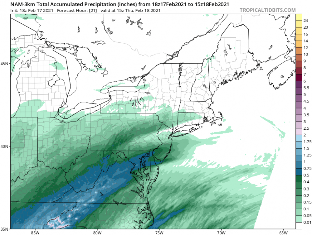
As Matt said, something’s off about the WB Kuchera map. This is the hour DC and southwest flip to sleet. The 0.5+” band is narrower than in the 12K, but its nowhere as funky as the Kuchera map suggests.-
2
-
-
5 minutes ago, clskinsfan said:
Heading out in a few minutes to get my second Covid vaccine shot. Apparently the side effects are worse for the second one. But I cannot wait to have my life back.
Most of my colleagues have gotten the second Moderna shot. Every single one had one or more of the following symptoms: fatigue, chills, body ache, muscle soreness, fever, severe headache. I am planning on taking Tylenol after the shot before going to bed.
-
1
-
-
1 minute ago, Bob Chill said:
Your dives into history are awesome. I love it as I cant drill down to the level of detail you do with memory. That said, if thurs isnt a carbon copy of the Feb 2014 all snow west track, it's an abject failure. Dont lose sight of ingrained irrationality and foolishness here.
Your quote let me see the typo I had in the original post- 2/21/15, not 2005. That’s the event you are referring to as well, I believe. One of the best day-of overperformers of all time. We were staring at the sleet line just not advance on the CC loop while it was hours of heavier than modeled snow accumulating during peak sun angle hours.
-
The way I am thinking about Thursday is these snow to sleet to freezing rain (to rain or dryslot) events happen with some regularity in our area. We often do fine on the front end thump for 2-4” for DC metro. Sometimes we get a pleasant overperformer like 12/14/03 or 2/25/07 where it’s more like 4-5”. Maybe the best all-time would be 2/21/15 where I received 7+” in North Bethesda and upper MoCo hit a foot. What the GFS is putting out for the first 12-hrs of QPF is very anomalous... in that all-time category type of way. I hope it verifies for sure, but I would be satisfied with a more typical event.
-
5
-
-
6 minutes ago, EHoffman said:
We always fail in borderline scenarios in mid-to-late February like this, yes. It's very rare we actually cash on a frozen-to-rain scenario like this.
2.6” at DCA before the changeover to ZR on 2/20/19 and 2.8” at DCA before the changeover on 2/15/16. Those performed more or less as expected and are just within the past 5 years.
-
7
-
-
Solid ice, not sleet, covering the sides of the paved alley here in N. Bethesda beside my building. Untreated sidewalks are glazed over as well. More ice on an actual street surface than on the trees is a new experience for me.
-
Good free radar alternative:
https://weather.cod.edu/satrad/nexrad/?parms=LWX-N0Q-0-24-100-usa-rad
On my phone, I have to tilt it sideways to be able to press the “play” button. But other than that, it works fine.
-
Anyone else wondering what’s going on with losetoa6? Really off punctuation and syntax for someone who usually posts coherently? Weird grudge?
ETA: I’m referring to the exchange with psuhoffman in the long range thread. Although the patterns in this thread are starting to make sense...-
1
-
-
Kind of interesting how this one 18Z 12K NAM run set off people in the way it did. Sure it was following the 12Z Euro, but it doesn’t even come close to agreeing with the 3K version of itself for the second wave. However we may end up failing, this one model run isn’t worth the anguish.
-
10 minutes ago, WxUSAF said:
I wouldn't discount the euro, but it's the driest/weakest with these waves relative to the other guidance. And it hasn't exactly nailed our previous storms, whereas a blended forecast from the guidance has done pretty well.
You’re the only one talking about blending the model guidance. I agree with you. Considering the precip max in the first wave is certainly not resolved yet, with the GFS, CMC, RGEM, 12Z NAM, even paltry 3K NAM all showing it near or north of DC, I don’t get the “foregone conclusion” feel in here right now.
-
12 minutes ago, H2O said:
oh who am I kidding. Enjoy!!!
We subscribe to KevOnStage so have seen his commentary videos on so many off-putting food demos over the years. There was another one recently where a guy makes mashed potatoes from potato chips. He chugs the greasy chip water at some point.
-
4 minutes ago, DDweatherman said:
Do we have any snow maps from 94 in PA? They got blitzed pretty good
-
This outcome is like a somewhat warmer version of 12/5/09. The MoCo banding even matches pretty well to that event.
-
2 minutes ago, HighStakes said:
Yes, exactly. I always give him a hard time but its tongue and cheek. He does seem like a nice guy and I do understand his location is really bad for snow but his message is a consistent negativity and it is with every event bar none.
Well, and today he happened to be posting a lot during a dead time in the thread, so it was like he was talking to himself.
-
1
-
 1
1
-
-
29 minutes ago, psuhoffman said:
I was only 7 and living in NJ. All I know is according to the local coop here there was only 11.5" of snow the entire winter and no single event more then 3". In 132 years of records I compiled using coop data it was the 4th least snowy winter and the 2nd worse in terms of the most pathetic "greatest snowfall" at 3". Only 1950 was worse. It's one of only 3 years in 132 that didn't feature a warning level event here. I don't care how amazing that cold front was that would have been a horrible winter that I would never want to go through again and would probably try to block from my memory. Looking at records it was also much colder then average which is another reason I do not chase arctic outbreaks. The often do us no good wrt snow.
I totally understand for your area, but for IAD and DCA, the 84/85 snow total was higher than *six* of the last ten seasons. A 10” month is often a climb for DCA, but 1/85 managed to hit that mark. A repeat down here would be subpar but on the upper band of that kind of winter and the extreme cold wave would mark it as memorable.
-
3 minutes ago, WxUSAF said:
They had 2.5" as of midnight. They only added 0.7" today?? When several nearby spotters reported 2-3" new??
That’s better than IAD, which only added 0.2”.

-
4 minutes ago, Bob Chill said:
God I hate bringing up this storm but there was a time not long ago where the euro amd everything else lined up a great hit but in real time the upper low wobbled SE and slp ended up tucked and more than a little south of prog'd. This storm's result was a heartbreaker but we're talking a real time shift at hour 0 that the euro missed. It's a perpetual cycle of worry parsing it. A trend of getting the waa totals slashed AND losing the ccb piece to the north is worth worrying about tho. I'm not seeing it yet anywhere
12/5-6/03 is an example discussed in these threads the past couple of days of a good WAA surge, then drizzle/mix all day while waiting and waiting for the CCB. The radar progression actually strikingly matches what a couple of models have been showing:
http://www.raymondcmartinjr.com/weather/2004/05-Dec-03-RegionalRadarImagery.html
I was driving home from DC to Potomac after a night out clubbing and ran into snow covered roads near home around 2 am. That band through predawn dropped another 3.5” after the 4” from the WAA. It wasn’t as much as forecast but still ended up being a decent storm around here. At least DC proper will be colder than that event for the WAA phase.
-
1
-
-
2 minutes ago, Ji said:
they had cantore at Dulles airport waiting the arrival of part 2 of the storm. It came but wasnt nearly as much as they thought.
It was a WWA for part 1 and WSW for part 2. Part 1 overperformed with some of the densest snow I’ve ever shoveled. Part 2 underperformed as you noted but still nicely freshened up the snow cover.
-
8 minutes ago, yoda said:
Can you post a link to that please? I can't find the link to that in my weather library of links lol
http://www.eas.slu.edu/CIPS/ANALOG/DFHR.php?reg=EC&fhr=F132&rundt=2021012712&map=thbCOOP72
Also displayed in a tweet on the first page of this thread.
-
1
-

February Banter 2021
in Mid Atlantic
Posted
There’s another prominent member too, like years and years active on the boards. But I’ll let him find his way to this thread.")